Margarette Falls: Difference between revisions
m (add needs) |
|||
| (16 intermediate revisions by 2 users not shown) | |||
| Line 1: | Line 1: | ||
{{Trail | |||
|Banner Image=File:Margarette falls 01.jpg | |||
|Trail Number=FS #189 | |||
|City=Greeneville | |||
|Land Owner=Cherokee National Forest | |||
|Trail Marking=Blue | |||
|Trail Use=Hiking, Geocaching | |||
|Trail Features=Waterfalls | |||
|Difficulty Rating=Medium | |||
|Hike Time=2 hrs | |||
|Trail Distance=1.3 mi | |||
|Round Trip Distance=2.6 | |||
|Trail Type=In-and-Out | |||
|High Point=2,521 ft | |||
|Low Point=1,854 ft | |||
|Elevation Gain=668 ft | |||
|Elevation Loss=0 ft | |||
|Elevation Change Direction=North-to-South | |||
|Parking location=36.06901, -82.71847 | |||
|Trailhead location=36.06901, -82.71847 | |||
}} | |||
<display_map center="36.065,-82.718468" type="terrain" zoom="15" height="600" width="auto" gkml="https://tehcc.org/clubwiki/kml/Margarette_Falls_trail.kml"> | |||
36.07063000,-82.71838000~Parking~ ~MarkerA.png | |||
36.07114387,-82.71832573~Trailhead~ ~MarkerG.png | |||
36.06510194,-82.71310364~Split with Bullen Hollow Trail~ ~MarkerG.png | |||
36.06135146,-82.71363639~Metal bridge~ ~MarkerL.png | |||
36.05845124,-82.71521001~Creek Crossing~ ~MarkerJ.png | |||
36.05773710,-82.71637912~Cathedral Rock~ ~MarkerD.png | |||
36.05643070,-82.71737321~Margarette Falls~ ~MarkerC.png | |||
</display_map> | |||
__TOC__ | |||
== Trail Overview == | == Trail Overview == | ||
<!-- Enter a overview of the trail. What attracts you to this trail, points of interest, types of flowers, lakes, and peaks that you see along the way. --> | <!-- Enter a overview of the trail. What attracts you to this trail, points of interest, types of flowers, lakes, and peaks that you see along the way. --> | ||
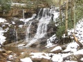
Short hike up a rocky path to a nice cascading falls, that in the winter can ice over very well. | |||
== How to get there == | == How to get there == | ||
| Line 60: | Line 54: | ||
== Route Description== | == Route Description== | ||
<!-- Detailed description of the route. Is there any side trails that are worth traveling? --> | <!-- Detailed description of the route. Is there any side trails that are worth traveling? --> | ||
Hike 0.6 miles up the Bullen Hollow Trail (blue blaze). The Margarette Falls Trail (FS #189) is apparently the second blazed trail off of Bullen Hollow Trail (do not ford main creek). It takes the right fork of the creek and the falls are about 0.75 miles from Bullen Trail intersection with | Hike 0.6 miles up the Bullen Hollow Trail (blue blaze). The Margarette Falls Trail (FS #189) is apparently the second blazed trail off of Bullen Hollow Trail (do not ford main creek). It takes the right fork of the creek and the falls are about 0.75 miles from Bullen Trail intersection with now just one ford on this trail. | ||
Do not follow the yellow blazes as those are for a very steep off-road vehicle trail to the top of Camp Creek Bald. | Do not follow the yellow blazes as those are for a very steep off-road vehicle trail to the top of Camp Creek Bald. | ||
[[File:Margarette Falls-profile.png|thumb|Elevation profile]] | |||
{| class="wikitable" border="1" | {| class="wikitable" border="1" | ||
|- | |- | ||
| Line 71: | Line 66: | ||
|- | |- | ||
|0.0 | |0.0 | ||
| | |1,854 | ||
|Trailhead | |Trailhead | ||
|- | |- | ||
|0.6 | |0.6 | ||
| | |2,100 | ||
|Fork for Bullen Hollow Trail | |Fork for Bullen Hollow Trail | ||
|- | |- | ||
|0.85 | |0.85 | ||
| | |2,521 | ||
|Bridge | |Metal Bridge | ||
|- | |- | ||
|1. | |1.3 | ||
|2600 | |2600 | ||
|Margarette Falls | |Margarette Falls | ||
|} | |} | ||
The trail is a consistent hike up hill with little descent on the outbound trip. Only a few short sections includes grades greater than 20%. | |||
== Typical Conditions == | == Typical Conditions == | ||
<!-- Typical conditions throughout the year of what to expect on the trail. Rocky, muddy, sandy, flowers, lots of downed trees? --> | <!-- Typical conditions throughout the year of what to expect on the trail. Rocky, muddy, sandy, flowers, lots of downed trees? --> | ||
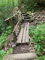
Trail improvements have installed three bridges, thus leaving just one creek crossing. The path is rough with lots of large boulders. | Trail improvements have installed three bridges, thus leaving just one creek crossing. The upper path section is very rough with lots of large boulders and roots; however, does appear a crew is trying to make upgrades. | ||
Stepping stones across the creek crossing are good if the water flow is not very high. Recommend trekking poles for stability. | |||
==Fees, Permits, etc. == | ==Fees, Permits, etc. == | ||
<!-- Please list any Fees, Permits, Regulations, etc. that may be required on this trail.--> | <!-- Please list any Fees, Permits, Regulations, etc. that may be required on this trail.--> | ||
None needed. | None needed. | ||
== Misc. Information == | == Misc. Information == | ||
<!-- Enter any additional information that doesn't fit an any other fields. Does this trail require any permits for overnight? parking? --> | <!-- Enter any additional information that doesn't fit an any other fields. Does this trail require any permits for overnight? parking? --> | ||
Greeneville Hiking Club has an excellent | Greeneville Hiking Club has an excellent [https://www.greenevilletnhikingcycling.com/uploads/1/2/7/6/127697960/margarettefalls.pdf Description of the trail]. They also have an extension on this [https://www.greenevilletnhikingcycling.com/uploads/1/2/7/6/127697960/baileyfalls.pdf hike up to Bailey Falls], which is another 1/3rd of a mile, but involves a difficult wall climb to the right of Margarette Falls. | ||
Per the [https://www.fs.usda.gov/recarea/cherokee/recarea/?recid=34888 Forest Service website], a thriving logging camp used to be located at the trailhead. At this location was a boarding house, dining hall, and several other support buildings. A railroad, locally known as the Pea Vine, carried logs from this forest on its twelve mile trip to Greeneville. | |||
== Photos == | == Photos == | ||
{{Park trail gallery|Trail={{PAGENAME}}}} | |||
Latest revision as of 20:56, 21 May 2023
| Margarette Falls (log in to submit report) | |
|---|---|

| |
| Trail Number | FS #189 |
| Land Owner | Cherokee National Forest |
| Located | Greeneville, Tennessee |
| Trail Marking | Blue |
| Trail UseThings allowed to do on or near the trail |
|
| FeaturesThings to see on or near the trail |
|
| Difficulty Rating | Medium |
| Hiking TimeTime from car and back. Includes any time hiking to access this trail. | 2 hrs0.125 Days <br />120 Min <br /> round trip |
| Distance: | 1.3 mi2.092 km <br /> trailStrict non-repeating trail length / 2.62.6 mi <br />4.184 km <br /> round tripTypical or shortest length from the car, hike the trail, and return to car |
| Trail Type | In-and-Out |
| Low / High Point | 1,854 ft618 Yards <br />565.099 Meters <br /> / 2,521 ft840.333 Yards <br />768.401 Meters <br /> |
| Elev. Gain/LossSee link for details of calculation. Gain/Loss is direction dependent. | 668 ft203.606 Meters <br /> / (0 ft0 Meters <br />) – North-to-South |
| Trip ReportsFrom user "hiked it" submissions<br />Recent is within last 90 days | 2 logged hikes (0 recent) |
| NearbyWithin 5 mi<br />Click link to view list | 1 trails / 2.5 mi of trail |
| Parking | 36° 4' 8.44" N, 82° 43' 6.49" W Map |
| Trailhead | 36° 4' 8.44" N, 82° 43' 6.49" W Map |
|
| |
| Show In Google Maps | |
Trail Overview[edit]
Short hike up a rocky path to a nice cascading falls, that in the winter can ice over very well.
How to get there[edit]
From Johnson City, TN
- Turn onto Cherokee Road, TN 67.
- In about 10 miles, turn left onto TN 81 (toward Erwin).
- On Tenn. 81, drive 0.8 miles (cross Nolichucky River).
- Turn right on TN 107 west (toward Tusculum).
- Drive 13.8 miles from TN 81/107 junction.
- Turn left toward USFS Horse Creek Recreation Area (sign).
- Proceed 0.8 miles.
- Turn right (sign -Horse Creek, Old Forge).
- Almost immediately (0.1 miles) turn right onto Union Chapel Road.
- Then after 0.2 miles, turn left onto Greene Ridge Road.
- After 0.6 miles turn left onto Greystone Road. Stay on most used route on narrow, winding road.
- At about 3.2 miles, turn left onto Shelton Mission Church Road (sign to church).
- Proceed 2.2 miles on Shelton Mission Chuch Road (pass church, cross bridge), and reach gravel road (USFS sign to Bullen Hollow and Margarette Falls Trails).
- Turn left and drive on rough road for 0.5 miles to turnaround and parking area.
Route Description[edit]
Hike 0.6 miles up the Bullen Hollow Trail (blue blaze). The Margarette Falls Trail (FS #189) is apparently the second blazed trail off of Bullen Hollow Trail (do not ford main creek). It takes the right fork of the creek and the falls are about 0.75 miles from Bullen Trail intersection with now just one ford on this trail.
Do not follow the yellow blazes as those are for a very steep off-road vehicle trail to the top of Camp Creek Bald.

| Miles | Elevation | Margarette Falls Trail |
|---|---|---|
| 0.0 | 1,854 | Trailhead |
| 0.6 | 2,100 | Fork for Bullen Hollow Trail |
| 0.85 | 2,521 | Metal Bridge |
| 1.3 | 2600 | Margarette Falls |
The trail is a consistent hike up hill with little descent on the outbound trip. Only a few short sections includes grades greater than 20%.
Typical Conditions[edit]
Trail improvements have installed three bridges, thus leaving just one creek crossing. The upper path section is very rough with lots of large boulders and roots; however, does appear a crew is trying to make upgrades.
Stepping stones across the creek crossing are good if the water flow is not very high. Recommend trekking poles for stability.
Fees, Permits, etc.[edit]
None needed.
Misc. Information[edit]
Greeneville Hiking Club has an excellent Description of the trail. They also have an extension on this hike up to Bailey Falls, which is another 1/3rd of a mile, but involves a difficult wall climb to the right of Margarette Falls.
Per the Forest Service website, a thriving logging camp used to be located at the trailhead. At this location was a boarding house, dining hall, and several other support buildings. A railroad, locally known as the Pea Vine, carried logs from this forest on its twelve mile trip to Greeneville.
Photos[edit]
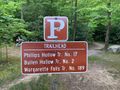
Trailhead sign
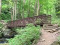
Metal bridge

Stepping stones for Dry Creek crossing
Wood bridge
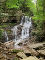
Margarette Falls in May

Profile: Trailhead to falls
Winter view of the falls - not well iced over


