Longarm Branch: Difference between revisions
(More info) |
(add hunting) |
||
| (7 intermediate revisions by 2 users not shown) | |||
| Line 1: | Line 1: | ||
{{Trail | {{Trail | ||
|Trail Highlight=Small cascading falls just past fourth | |Trail Highlight=Small cascading falls just past fourth crossing of Longarm Branch | ||
|Trail Number=FS #1901 | |Trail Number=FS #1901 | ||
|Park=Clarks Creek | |Park=Clarks Creek | ||
|Land Owner=Cherokee National Forest | |Land Owner=Cherokee National Forest | ||
|Trail Marking=Yellow | |Trail Marking=Yellow | ||
|Trail Use=Hiking, Biking, Horses | |Trail Use=Hiking, Biking, Camping, Horses, Hunting | ||
|Trail Features=Waterfalls | |Trail Features=Waterfalls | ||
|Difficulty Rating=Medium | |Difficulty Rating=Medium | ||
|Hike Time=4 hrs | |||
|Trail Distance=3.6 | |Trail Distance=3.6 | ||
|Round Trip Distance=7.2 | |Round Trip Distance=7.2 | ||
|Trail Type=In-and-Out | |Trail Type=In-and-Out | ||
|High Point=1 ft | |||
|Low Point=0 ft | |||
|Elevation Gain=1 ft | |||
|Elevation Loss=-1 ft | |||
|Elevation Change Direction=North-to-South | |Elevation Change Direction=North-to-South | ||
|Parking location=36.12519, -82.53782 | |Parking location=36.12519, -82.53782 | ||
|Trailhead location=36.12519, -82.53782 | |||
}} | }} | ||
{{Trail Map}} | {{Trail Map}} | ||
| Line 19: | Line 25: | ||
== Trail Overview == | == Trail Overview == | ||
Located in [[Clarks Creek | Located in [[Clarks Creek]]. Forest Service Trail #1901 per trailhead marker. Moderately challenging trail leading to Bearwallow Gap on Rich Mountain. | ||
== How to get there == | == How to get there == | ||
<!-- Please enter detailed instruction on how to find the trail head. --> | <!-- Please enter detailed instruction on how to find the trail head. --> | ||
From the end of the paved portion of Clarks Creek Road, continue 1.9 miles (total of 3.3 since leaving TN107) trail head parking. | From the end of the paved portion of Clarks Creek Road, continue 1.9 miles (total of 3.3 since leaving TN107) trail head parking. There is a small pulloff loop for four vehicles off main road. | ||
== Route Description== | == Route Description== | ||
<!-- Detailed description of the route. Is there any side trails that are worth traveling? --> | <!-- Detailed description of the route. Is there any side trails that are worth traveling? --> | ||
Details to come later. | Details to come later. | ||
Path forks with Longarm Branch Trail continuing right, while | |||
Path forks with Longarm Branch Trail continuing right, while a short spur trail heads to the left uphill to a small plunge waterfall on the Devil Fork stream. | |||
== Typical Conditions == | == Typical Conditions == | ||
<!-- Typical conditions throughout the year of what to expect on the trail. Rocky, muddy, sandy, flowers, lots of downed trees? --> | <!-- Typical conditions throughout the year of what to expect on the trail. Rocky, muddy, sandy, flowers, lots of downed trees? --> | ||
Rocky and muddy (after heavy rain) forest road with several stream crossings. While trailhead sign stated that mountain bikes and horses are allowed, there was no indication of their presence in recent months as of August 2020. Yellow blazes could be refreshed. | |||
==Fees, Permits, etc. == | ==Fees, Permits, etc. == | ||
| Line 40: | Line 47: | ||
== Photos == | == Photos == | ||
{{Park trail gallery|Trail={{PAGENAME}}}} | {{Park trail gallery|Trail={{PAGENAME}}}} | ||
{{Map Marker | |||
|Icon Type=Water crossing | |||
|Marker Title=First crossing | |||
|Marker Location=36.1209633333333333,-82.538975 | |||
}} | |||
{{Map Marker | |||
|Icon Type=Waterfall | |||
|Marker Title=Small plunge waterfall | |||
|Marker Description=On Devil Fork stream | |||
|Marker Location=36.1202333333333333,-82.53745 | |||
}} | |||
{{Map Marker | |||
|Icon Type=Point of interest | |||
|Marker Title=Trail split | |||
|Marker Description=Spur to waterfall on Devil Fork | |||
|Marker Location=36.1208266666666667,-82.5390383333333333 | |||
}} | |||
{{Map Marker | {{Map Marker | ||
|Icon Type=Parking | |Icon Type=Parking | ||
|Marker Title=Trailhead parking area | |||
|Marker Location=36.125185, -82.537817 | |Marker Location=36.125185, -82.537817 | ||
}} | }} | ||
Latest revision as of 22:21, 18 September 2021
| Longarm Branch (log in to submit report) | |
|---|---|
| Highlight | Small cascading falls just past fourth crossing of Longarm Branch |
| Trail Number | FS #1901 |
| Park | Clarks Creek |
| Land Owner | Cherokee National Forest |
| Located | Erwin, TennesseeLocation inherited from associated park |
| Trail Marking | Yellow |
| Trail UseThings allowed to do on or near the trail |
|
| FeaturesThings to see on or near the trail |
|
| Difficulty Rating | Medium |
| Hiking TimeTime from car and back. Includes any time hiking to access this trail. | 4 hrs0.25 Days <br />240 Min <br /> round trip |
| Distance: | 3.63.6 Mi <br />5.794 km <br /> trailStrict non-repeating trail length / 7.27.2 mi <br />11.587 km <br /> round tripTypical or shortest length from the car, hike the trail, and return to car |
| Trail Type | In-and-Out |
| Low / High Point | 0 ft0 Yards <br />0 Meters <br /> / 1 ft0.333 Yards <br />0.305 Meters <br /> |
| Elev. Gain/LossSee link for details of calculation. Gain/Loss is direction dependent. | 1 ft0.305 Meters <br /> / (-1 ft-0.305 Meters <br />) – North-to-South |
| Trip ReportsFrom user "hiked it" submissions<br />Recent is within last 90 days | 1 logged hikes (0 recent) |
| NearbyWithin 5 mi<br />Click link to view list | 3 trails / 10.3 mi of trail |
| Parking | 36° 7' 30.68" N, 82° 32' 16.15" W Map |
| Trailhead | 36° 7' 30.68" N, 82° 32' 16.15" W Map |
|
| |
| Show In Google Maps | |
Trail Overview[edit]
Located in Clarks Creek. Forest Service Trail #1901 per trailhead marker. Moderately challenging trail leading to Bearwallow Gap on Rich Mountain.
How to get there[edit]
From the end of the paved portion of Clarks Creek Road, continue 1.9 miles (total of 3.3 since leaving TN107) trail head parking. There is a small pulloff loop for four vehicles off main road.
Route Description[edit]
Details to come later.
Path forks with Longarm Branch Trail continuing right, while a short spur trail heads to the left uphill to a small plunge waterfall on the Devil Fork stream.
Typical Conditions[edit]
Rocky and muddy (after heavy rain) forest road with several stream crossings. While trailhead sign stated that mountain bikes and horses are allowed, there was no indication of their presence in recent months as of August 2020. Yellow blazes could be refreshed.
Fees, Permits, etc.[edit]
No fee required.
Photos[edit]
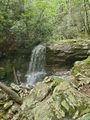
Small waterfall on Devil Fork
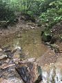
first stream crossing
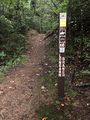
Trailhead signpost


