|
|
|
|
|
| Trail Name
|
Laurel Run Trail
|
| Nearest City
|
Church Hill
|
| State
|
Tennessee
|
| Trail Marking
|
{{{Marking}}}
|
| Trail Use/Features
|
  
|
| Difficulty Rating
|
Moderate
|
| Hiking Time
|
*"*" is not a number.
|
| Distance, round-trip
|
2.52.5 mi <br />4.023 km <br />
|
| Climb/Descent Elevation
|
*"*" is not a number. / {{{Elevation Loss}}}"{{{Elevation Loss}}}" is not a number.
|
| High Point
|
*"*" is not a number.
|
| Nearest Medical
|
Church Hill
|
| Trip Reports
|
Click Here
|
|
|
Loading map... {"type":"ROADMAP","minzoom":false,"maxzoom":false,"types":["ROADMAP","SATELLITE","HYBRID","TERRAIN"],"mappingservice":"googlemaps3","width":"270px","height":"180px","centre":false,"title":"","label":"","icon":"","lines":[],"polygons":[],"circles":[],"rectangles":[],"copycoords":false,"static":false,"visitedicon":"","wmsoverlay":false,"zoom":8,"layers":[],"controls":["zoom"],"zoomstyle":"DEFAULT","typestyle":"DEFAULT","autoinfowindows":false,"resizable":false,"kmlrezoom":false,"poi":true,"cluster":false,"clustergridsize":60,"clustermaxzoom":20,"clusterzoomonclick":true,"clusteraveragecenter":true,"clusterminsize":2,"imageoverlays":[],"kml":[],"gkml":[],"searchmarkers":"","fullscreen":false,"scrollwheelzoom":false,"locations":[{"text":"","title":"","link":"","lat":36.494180000000000063664629124104976654052734375,"lon":-82.679720000000003210516297258436679840087890625,"icon":""}]} |
|
| Show Large Map
|
|
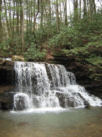
Trail Overview
When folks say they are going hiking at Laurel Run Park, they generally mean taking Kiner Hollow Trail up to the waterfalls. Kiner Hollow Trail is actually part of the Bays Mountain Park system, but the description and details will be maintained here.
How to get there
- Take Highway 11W through Church Hill.
- Turn left (south) at Goshen Valley Road.
- Cross the bridge over the Holston River.
- At just under a mile, turn left (east) at River Road.
- After just under two miles, veer left onto Laurel Run Park Road.
- Continue into the park (warning - several speed bumps after entering gate)
- Once the park road tees, turn right toward the amphitheater parking lot.
- Trailhead is past the shelters starting with the gravel road.
Route Description
Hike 0.5 miles up the Bullen Hollow Trail. The Margarette Falls Trail is apparently the second blazed trail off of Bullen Hollow Trail (do not ford main creek). It takes the right fork of the creek and the falls are about 0.75 miles from Bullen Trail intersection with several fords on this trail.
Typical Conditions
Fees, Permits, etc.
None needed.
After the Hike
Misc. Information
Maps
Photos

