Laurel Run Trail: Difference between revisions
(Update IB to new format) |
(Add trail features) |
||
| (25 intermediate revisions by 4 users not shown) | |||
| Line 1: | Line 1: | ||
{{Trail | |||
{{ | |Banner Image=File:Lower Kiner Hollow Falls.jpg | ||
|Park=Bays Mountain Park | |||
|City=Kingsport | |||
|Land Owner=City of Kingsport | |||
|Trail Marking=White | |||
|Trail Use=Hiking, Biking, Geocaching | |||
|Trail Features=Waterfalls, Rivers | |||
|Difficulty Rating=Medium | |||
|Hike Time=3.0 hrs | |||
|Trail Distance=1.89 mi | |||
|Round Trip Distance=3.78 mi | |||
|Trail Type=In-and-Out | |||
|High Point=1,750 Ft | |||
|Low Point=1,168 ft | |||
|Elevation Gain=618 Ft | |||
|Elevation Loss=37 Ft | |||
|Elevation Change Direction=West-to-East | |||
|Parking location=36.49679, -82.68063 | |||
|Trailhead location=36.49493, -82.67962 | |||
}} | }} | ||
{{Trail Map|Other Trails=Kiner Hollow Trail}} | |||
Laurel Run Trail in Red, optional Overlook in Orange, [[Kiner Hollow Trail]] in Yellow. | |||
__TOC__ | |||
== Trail Overview == | == Trail Overview == | ||
<!-- Enter a overview of the trail. What attracts you to this trail, points of interest, types of flowers, lakes, and peaks that you see along the way. --> | <!-- Enter a overview of the trail. What attracts you to this trail, points of interest, types of flowers, lakes, and peaks that you see along the way. --> | ||
'''Note!''' Parking location for this trail is set to Laurel Run Park, not the typical parking spot for Bays Mountain Park, the park the trail mostly resides within. | |||
When folks say they are going hiking at Laurel Run Park, they generally mean taking Laurel Run Trail up Kiner Hollow to the waterfalls. Laurel Run Trail is actually mostly in the [[Bays Mountain Park]] system, but the description and details will be maintained here. | When folks say they are going hiking at Laurel Run Park, they generally mean taking Laurel Run Trail up Kiner Hollow to the waterfalls. Laurel Run Trail is actually mostly in the [[Bays Mountain Park]] system, but the description and details will be maintained here. | ||
== How to get there == | == How to get there == | ||
<!-- Please enter detailed instruction on how to find the trail head. --> | <!-- Please enter detailed instruction on how to find the trail head. --> | ||
Street address: 364 Laurel Run Park Rd, Church Hill, TN 37642 | |||
#Take Highway 11W through Church Hill. | #Take Highway 11W through Church Hill. | ||
#Turn left (south) at Goshen Valley Road. | #Turn left (south) at Goshen Valley Road. | ||
| Line 36: | Line 45: | ||
== Route Description== | == Route Description== | ||
<!-- Detailed description of the route. Is there any side trails that are worth traveling? --> | <!-- Detailed description of the route. Is there any side trails that are worth traveling? --> | ||
Starting at the green "Walking Trail" sign, follow the gravel road around the bend and across the new footbridge (which greatly improves this stream crossing). Continue following the roadway up the hill. The tread will become very muddy in places - especially after rain even days before. The trail climbs on the old logging road rising above the creek, and then coming back down | Starting at the green "Walking Trail" sign, follow the gravel road around the bend and across the new footbridge (which greatly improves this stream crossing). Continue following the roadway up the hill. The tread will become very muddy in places - especially after rain even days before. The trail climbs on the old logging road rising above the creek, and then coming back down. | ||
Just past the lower falls, there is a basin that is commonly used as a swimming hole. The white-blazed trail soon makes a sharp switchback up the hill. The climbing path passes above the small upper falls. The route wanders past a few abandoned homesteads until it finally intersects with the [[Kiner Hollow Trail]]. | Overlook Trail: An option exists for a strenuous extension on your right upon hike departure to take a steep climb to an overlook spot above the Holston River looking towards the Clinch Mountains. Its kml has been posted on the above map, but a separate trail wiki page has not been created. The path follows a forest road loop to rejoin with the Laurel Run Trail. However, the 0.9-mile Overlook Trail is not formally maintained, but generally passable. | ||
The second creek crossing does not have a bridge, thus is either rock hopping or wading. The trail then rises another ridge up to the lower falls (see photo in banner). For most folks, this waterfall is their destination. | |||
Just past the lower falls, there is a basin that is commonly used as a swimming hole. The white-blazed trail soon makes a sharp switchback up the hill. The climbing path passes above the small upper falls. The route wanders past a few abandoned homesteads until it finally intersects with the [[Trail connects to::Kiner Hollow Trail]]. | |||
{| class="wikitable" border="1" | {| class="wikitable" border="1" | ||
| Line 61: | Line 74: | ||
|1.9 | |1.9 | ||
| | | | ||
|- | |||
|- | |- | ||
|0.3 | |0.3 | ||
|Junction with Overlook Trail - signed lower end heads steeply uphill to view above Holston River | |||
|1.7 | |||
|1231 | |||
|- | |||
|- | |||
|0.5 | |||
|Junction with Overlook Trail - unmarked upper end heads uphill | |||
|1.5 | |||
|1327 | |||
|- | |||
|0.7 | |||
|Bridgeless creek crossing - enter Bays Mountain Park (no sign) | |Bridgeless creek crossing - enter Bays Mountain Park (no sign) | ||
|1. | |1.3 | ||
| | | | ||
|- | |- | ||
| Line 105: | Line 130: | ||
== Typical Conditions == | == Typical Conditions == | ||
<!-- Typical conditions throughout the year of what to expect on the trail. Rocky, muddy, sandy, flowers, lots of downed trees? --> | <!-- Typical conditions throughout the year of what to expect on the trail. Rocky, muddy, sandy, flowers, lots of downed trees? --> | ||
One significant creek crossing. Sections of the trail can be very muddy. Mostly up and up and up. | One significant creek crossing. Sections of the trail can be very muddy thus not recommended after rain even several days before. Mostly up and up and up. | ||
Significant erosion of the main path as seen in a picture in [https://www.timesnews.net/opinion/editorials/editorial-laurel-run-park-is-well-worth-preserving/article_d3fd4ed6-c2ea-11eb-997e-ff462e0b14a3.html this local newspaper editorial]. The funding requested, however, is for shoreline erosion along the Holston River. | |||
==Fees, Permits, etc. == | ==Fees, Permits, etc. == | ||
<!-- Please list any Fees, Permits, Regulations, etc. that may be required on this trail.--> | <!-- Please list any Fees, Permits, Regulations, etc. that may be required on this trail.--> | ||
None needed. | None needed. | ||
[https://rogersvilletnchamber.com/laurel-run-park/) Laurel Run Park Hours] | |||
{| class="wikitable" | |||
|- | |||
! Months !! Opens !! Closes | |||
|- | |||
| January through March || 8:00 a.m. || 4:00 p.m. | |||
|- | |||
| April || 8:00 a.m. || 7:00 p.m | |||
|- | |||
| May through August || 8:00 a.m. || 8:00 p.m | |||
|- | |||
| September || 8:00 a.m. || 7:00 p.m. | |||
|- | |||
| October || 8:00 a.m. || 6:00 p.m. | |||
|- | |||
| November to December || 8:00 a.m. || 4:00 p.m. | |||
|} | |||
== After the Hike == | == After the Hike == | ||
<!-- Anywhere interesting to stop by since you're in the area!! --> | <!-- Anywhere interesting to stop by since you're in the area!! --> | ||
Laurel Run Park has multiple areas for picnicking, a paved walking path, a playground, a frisbee golf course, tennis courts, basketball court, and softball field. | |||
== Misc. Information == | == Misc. Information == | ||
<!-- Enter any additional information that doesn't fit an any other fields. Does this trail require any permits for overnight? parking? --> | <!-- Enter any additional information that doesn't fit an any other fields. Does this trail require any permits for overnight? parking? --> | ||
Mountain biking is allowed on the upper section of the trail, but too difficult so never seen anyone on a bike. | Mountain biking is allowed on the upper section of the trail, but too difficult so never seen anyone on a bike. | ||
== Photos == | == Photos == | ||
{{Park trail gallery|Trail={{PAGENAME}}}} | |||
{{Map Marker | |||
|Icon Type=Overlook | |||
|Marker Title=Overlook to north | |||
|Marker Location=36.493882, -82.683741 | |||
}} | |||
{{Map Marker | |||
|Icon Type=Point of interest | |||
|Marker Title=Overlook trail | |||
|Marker Description=Upper intersection | |||
|Marker Location=36.488230, -82.678085 | |||
}} | |||
{{Map Marker | |||
|Icon Type=Trail sign | |||
|Marker Title=Overlook trail | |||
|Marker Description=Lower intersection | |||
|Marker Location=36.492642, -82.679415 | |||
}} | |||
{{Map Marker | |||
|Icon Type=Trail bridge | |||
|Marker Title=Footbridge | |||
|Marker Description=2020 Eagle project | |||
|Marker Location=36.494166, -82.679904 | |||
}} | |||
Latest revision as of 13:20, 11 July 2021
| Laurel Run Trail (log in to submit report) | |
|---|---|

| |
| Park | Bays Mountain Park |
| Land Owner | City of Kingsport |
| Located | Kingsport, Tennessee |
| Trail Marking | White |
| Trail UseThings allowed to do on or near the trail |
|
| FeaturesThings to see on or near the trail |
|
| Difficulty Rating | Medium |
| Hiking TimeTime from car and back. Includes any time hiking to access this trail. | 3.0 hrs0.188 Days <br />180 Min <br /> round trip |
| Distance: | 1.89 mi3.042 km <br /> trailStrict non-repeating trail length / 3.78 mi6.083 km <br /> round tripTypical or shortest length from the car, hike the trail, and return to car |
| Trail Type | In-and-Out |
| Low / High Point | 1,168 ft389.333 Yards <br />356.006 Meters <br /> / 1,750 Ft583.333 Yards <br />533.4 Meters <br /> |
| Elev. Gain/LossSee link for details of calculation. Gain/Loss is direction dependent. | 618 Ft188.366 Meters <br /> / (37 Ft11.278 Meters <br />) – West-to-East |
| Trip ReportsFrom user "hiked it" submissions<br />Recent is within last 90 days | 6 logged hikes (0 recent) |
| NearbyWithin 5 mi<br />Click link to view list | 30 trails / 36.6 mi of trail |
| Parking | 36° 29' 48.44" N, 82° 40' 50.27" W Map |
| Trailhead | 36° 29' 41.75" N, 82° 40' 46.63" W Map |
|
| |
| Show In Google Maps | |
Download KML / Upload new version / KML File Page / Create Profile Chart / gpsvisualizer Map
Laurel Run Trail in Red, optional Overlook in Orange, Kiner Hollow Trail in Yellow.
Trail Overview[edit]
Note! Parking location for this trail is set to Laurel Run Park, not the typical parking spot for Bays Mountain Park, the park the trail mostly resides within.
When folks say they are going hiking at Laurel Run Park, they generally mean taking Laurel Run Trail up Kiner Hollow to the waterfalls. Laurel Run Trail is actually mostly in the Bays Mountain Park system, but the description and details will be maintained here.
How to get there[edit]
Street address: 364 Laurel Run Park Rd, Church Hill, TN 37642
- Take Highway 11W through Church Hill.
- Turn left (south) at Goshen Valley Road.
- Cross the bridge over the Holston River.
- At just under a mile, turn left (east) at River Road.
- After just under two miles, veer left onto Laurel Run Park Road.
- Continue into the park (warning - several speed bumps after entering gate)
- Once the park road tees, turn right toward the amphitheater parking lot.
- Trailhead is past the shelters starting with the gravel road.
Route Description[edit]
Starting at the green "Walking Trail" sign, follow the gravel road around the bend and across the new footbridge (which greatly improves this stream crossing). Continue following the roadway up the hill. The tread will become very muddy in places - especially after rain even days before. The trail climbs on the old logging road rising above the creek, and then coming back down.
Overlook Trail: An option exists for a strenuous extension on your right upon hike departure to take a steep climb to an overlook spot above the Holston River looking towards the Clinch Mountains. Its kml has been posted on the above map, but a separate trail wiki page has not been created. The path follows a forest road loop to rejoin with the Laurel Run Trail. However, the 0.9-mile Overlook Trail is not formally maintained, but generally passable.
The second creek crossing does not have a bridge, thus is either rock hopping or wading. The trail then rises another ridge up to the lower falls (see photo in banner). For most folks, this waterfall is their destination.
Just past the lower falls, there is a basin that is commonly used as a swimming hole. The white-blazed trail soon makes a sharp switchback up the hill. The climbing path passes above the small upper falls. The route wanders past a few abandoned homesteads until it finally intersects with the Kiner Hollow Trail.
| Miles | Laurel Run Trail | Miles | Elevation (ft) |
|---|---|---|---|
| 0.0 | Start at gravel road past shelters at Laurel Run Park | 2.0 | 1147 |
| 0.1 | New footbridge across creek | 1.9 | |
| 0.1 | Old house | 1.9 | |
| 0.3 | Junction with Overlook Trail - signed lower end heads steeply uphill to view above Holston River | 1.7 | 1231 |
| 0.5 | Junction with Overlook Trail - unmarked upper end heads uphill | 1.5 | 1327 |
| 0.7 | Bridgeless creek crossing - enter Bays Mountain Park (no sign) | 1.3 | |
| 0.9 | Waterfall | 1.1 | |
| 1.0 | Switchbacks | 1.0 | 1436 |
| 1.1 | Kiner Falls off and below trail | 0.9 | |
| 1.3 | Abandoned Morrison family house - stay out! | 0.7 | |
| 1.6 | Abandoned Asa Simpson house - stay out! | 0.4 | |
| 1.7 | Abandoned Alex Wallen house - mostly torn down - stay out! | 0.3 | |
| 2.0 | Junction with Kiner Hollow Trail at creek | 0.0 | 1760 |
Typical Conditions[edit]
One significant creek crossing. Sections of the trail can be very muddy thus not recommended after rain even several days before. Mostly up and up and up.
Significant erosion of the main path as seen in a picture in this local newspaper editorial. The funding requested, however, is for shoreline erosion along the Holston River.
Fees, Permits, etc.[edit]
None needed.
| Months | Opens | Closes |
|---|---|---|
| January through March | 8:00 a.m. | 4:00 p.m. |
| April | 8:00 a.m. | 7:00 p.m |
| May through August | 8:00 a.m. | 8:00 p.m |
| September | 8:00 a.m. | 7:00 p.m. |
| October | 8:00 a.m. | 6:00 p.m. |
| November to December | 8:00 a.m. | 4:00 p.m. |
After the Hike[edit]
Laurel Run Park has multiple areas for picnicking, a paved walking path, a playground, a frisbee golf course, tennis courts, basketball court, and softball field.
Misc. Information[edit]
Mountain biking is allowed on the upper section of the trail, but too difficult so never seen anyone on a bike.
Photos[edit]
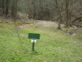
Trailhead for Laurel Run Trail - photo by Vic Hasler
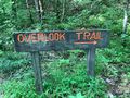
Overlook Trail sign
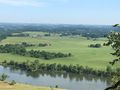
Overlook Trail - Holston River with Clinch Mtns
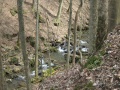
Cascading creek below the Laurel Run Trail - photo by Vic Hasler
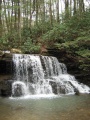
Lower Kiner Hollow Falls - photo by Vic Hasler


