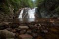
Swimming is not allowed at the falls because of dangerous undertow in the pool. SEVERAL PEOPLE HAVE DIED HERE INCLUDING THOSE COMING TO HELP. They were not being seemingly careless, not drinking, not jumping from the top, simply swimming near the falls. There is an underwater rock shelf in the deep pool below the falls. The strong current will take swimmers underwater and keep them trapped below the shelf. Therefore, wading downstream of the falls is suggested for enjoyment.
Follow blue blazed trail to AT.
The listed mileage and elevation change are for complete end-to-end and return hike. More typically the day hikes are an out-and-back from either access point. From Hampton, it's a 5.5 mile round trip. From Dennis Cove, it's about 2.6 miles round trip.
Well maintained Appalachian Trail, including blue blazed side trail from Hampton. Sometimes during spring, the upper trail may be required due to flooding.
Group size is limited to 10 people in the Pond Mountain Wilderness Area. Also dogs must be on leashes.
Overnight parking is not recommended at Hampton trailhead due to occasional vandalism to break into vehicles to steal items.
Loading map...
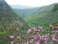
{"type":"TERRAIN","minzoom":false,"maxzoom":false,"types":["ROADMAP","SATELLITE","HYBRID","TERRAIN"],"mappingservice":"googlemaps3","width":"auto","height":"750px","centre":false,"title":"","label":"","icon":"","lines":[],"polygons":[],"circles":[],"rectangles":[],"copycoords":false,"static":false,"visitedicon":"","wmsoverlay":false,"zoom":14,"layers":[],"controls":["pan","zoom","type","scale","streetview","rotate"],"zoomstyle":"DEFAULT","typestyle":"DEFAULT","autoinfowindows":false,"resizable":false,"kmlrezoom":false,"poi":true,"cluster":false,"clustergridsize":60,"clustermaxzoom":20,"clusterzoomonclick":true,"clusteraveragecenter":true,"clusterminsize":2,"imageoverlays":[],"kml":[],"gkml":["http://tehcc.org/clubwiki/kml/Hampton_Blueline_Trail_501.kml","http://tehcc.org/clubwiki/kml/High_Water_Trail.kml"],"searchmarkers":"","fullscreen":false,"scrollwheelzoom":false,"locations":[{"text":"\u003Cb\u003E\u003Cdiv class=\"mw-parser-output\"\u003E\u003Cp\u003ELaurel Fork Falls\n\u003C/p\u003E\u003C/div\u003E\u003C/b\u003E\u003Cdiv class=\"mw-parser-output\"\u003E\u003Cp\u003E\u003Ca href=\"/wiki/File:Laurel_Fork_Gorge_Falls.JPG\" class=\"image\"\u003E\u003Cimg alt=\"Laurel Fork Gorge Falls.JPG\" src=\"/clubwiki/images/thumb/Laurel_Fork_Gorge_Falls.JPG/150px-Laurel_Fork_Gorge_Falls.JPG\" decoding=\"async\" width=\"150\" height=\"182\" srcset=\"/clubwiki/images/thumb/Laurel_Fork_Gorge_Falls.JPG/225px-Laurel_Fork_Gorge_Falls.JPG 1.5x, /clubwiki/images/thumb/Laurel_Fork_Gorge_Falls.JPG/300px-Laurel_Fork_Gorge_Falls.JPG 2x\" data-file-width=\"768\" data-file-height=\"932\" /\u003E\u003C/a\u003E\n\u003C/p\u003E\u003C/div\u003E","title":"Laurel Fork Falls\n","link":"","lat":36.27277000000000128920873976312577724456787109375,"lon":-82.1350000000000051159076974727213382720947265625,"icon":"/clubwiki/images/MarkerC.png"},{"text":"\u003Cdiv class=\"mw-parser-output\"\u003E\u003Cp\u003ETrailhead - Dennis Cove\n\u003C/p\u003E\u003C/div\u003E","title":"Trailhead - Dennis Cove\n","link":"","lat":36.2640669999999971651050145737826824188232421875,"lon":-82.123099999999993769961292855441570281982421875,"icon":"/clubwiki/images/MarkerA.png"},{"text":"\u003Cb\u003E\u003Cdiv class=\"mw-parser-output\"\u003E\u003Cp\u003ETrailhead - Hampton\n\u003C/p\u003E\u003C/div\u003E\u003C/b\u003E\u003Cdiv class=\"mw-parser-output\"\u003E\u003Cp\u003E\u003Ca href=\"/wiki/File:Laurel_Fork_Trailhead_sign.JPG\" class=\"image\"\u003E\u003Cimg alt=\"Laurel Fork Trailhead sign.JPG\" src=\"/clubwiki/images/thumb/Laurel_Fork_Trailhead_sign.JPG/150px-Laurel_Fork_Trailhead_sign.JPG\" decoding=\"async\" width=\"150\" height=\"160\" srcset=\"/clubwiki/images/thumb/Laurel_Fork_Trailhead_sign.JPG/225px-Laurel_Fork_Trailhead_sign.JPG 1.5x, /clubwiki/images/thumb/Laurel_Fork_Trailhead_sign.JPG/300px-Laurel_Fork_Trailhead_sign.JPG 2x\" data-file-width=\"768\" data-file-height=\"820\" /\u003E\u003C/a\u003E\n\u003C/p\u003E\u003C/div\u003E","title":"Trailhead - Hampton\n","link":"","lat":36.2853199999999986857801559381186962127685546875,"lon":-82.152119999999996480255504138767719268798828125,"icon":"/clubwiki/images/MarkerA.png"},{"text":"\u003Cb\u003E\u003Cdiv class=\"mw-parser-output\"\u003E\u003Cp\u003EEntering Pond Mtn Wilderness\n\u003C/p\u003E\u003C/div\u003E\u003C/b\u003E\u003Cdiv class=\"mw-parser-output\"\u003E\u003Cp\u003E\u003Ca href=\"/wiki/File:Laurel_Fork_Gorge_Pond_Mtn_Wilderness.JPG\" class=\"image\"\u003E\u003Cimg alt=\"Laurel Fork Gorge Pond Mtn Wilderness.JPG\" src=\"/clubwiki/images/thumb/Laurel_Fork_Gorge_Pond_Mtn_Wilderness.JPG/150px-Laurel_Fork_Gorge_Pond_Mtn_Wilderness.JPG\" decoding=\"async\" width=\"150\" height=\"275\" srcset=\"/clubwiki/images/thumb/Laurel_Fork_Gorge_Pond_Mtn_Wilderness.JPG/225px-Laurel_Fork_Gorge_Pond_Mtn_Wilderness.JPG 1.5x, /clubwiki/images/Laurel_Fork_Gorge_Pond_Mtn_Wilderness.JPG 2x\" data-file-width=\"244\" data-file-height=\"448\" /\u003E\u003C/a\u003E\n\u003C/p\u003E\u003C/div\u003E","title":"Entering Pond Mtn Wilderness\n","link":"","lat":36.2821100000000029695002012886106967926025390625,"lon":-82.1485200000000048703441279940307140350341796875,"icon":"/clubwiki/images/MarkerG.png"},{"text":"\u003Cb\u003E\u003Cdiv class=\"mw-parser-output\"\u003E\u003Cp\u003EIntersection with AT\n\u003C/p\u003E\u003C/div\u003E\u003C/b\u003E\u003Cdiv class=\"mw-parser-output\"\u003E\u003Cp\u003E\u003Ca href=\"/wiki/File:AT_Laurel_Fork_Gorge_sign.JPG\" class=\"image\"\u003E\u003Cimg alt=\"AT Laurel Fork Gorge sign.JPG\" src=\"/clubwiki/images/thumb/AT_Laurel_Fork_Gorge_sign.JPG/150px-AT_Laurel_Fork_Gorge_sign.JPG\" decoding=\"async\" width=\"150\" height=\"116\" srcset=\"/clubwiki/images/thumb/AT_Laurel_Fork_Gorge_sign.JPG/225px-AT_Laurel_Fork_Gorge_sign.JPG 1.5x, /clubwiki/images/thumb/AT_Laurel_Fork_Gorge_sign.JPG/300px-AT_Laurel_Fork_Gorge_sign.JPG 2x\" data-file-width=\"993\" data-file-height=\"768\" /\u003E\u003C/a\u003E\n\u003C/p\u003E\u003C/div\u003E","title":"Intersection with AT\n","link":"","lat":36.281509999999997262420947663486003875732421875,"lon":-82.1432300000000026329871616326272487640380859375,"icon":"/clubwiki/images/MarkerG.png"},{"text":"\u003Cb\u003E\u003Cdiv class=\"mw-parser-output\"\u003E\u003Cp\u003ETrail Bridge #1\n\u003C/p\u003E\u003C/div\u003E\u003C/b\u003E\u003Cdiv class=\"mw-parser-output\"\u003E\u003Cp\u003E\u003Ca href=\"/wiki/File:Laurel_Fork_Gorge_bridge1.JPG\" class=\"image\"\u003E\u003Cimg alt=\"Laurel Fork Gorge bridge1.JPG\" src=\"/clubwiki/images/thumb/Laurel_Fork_Gorge_bridge1.JPG/150px-Laurel_Fork_Gorge_bridge1.JPG\" decoding=\"async\" width=\"150\" height=\"176\" srcset=\"/clubwiki/images/thumb/Laurel_Fork_Gorge_bridge1.JPG/225px-Laurel_Fork_Gorge_bridge1.JPG 1.5x, /clubwiki/images/thumb/Laurel_Fork_Gorge_bridge1.JPG/300px-Laurel_Fork_Gorge_bridge1.JPG 2x\" data-file-width=\"768\" data-file-height=\"901\" /\u003E\u003C/a\u003E\n\u003C/p\u003E\u003C/div\u003E","title":"Trail Bridge #1\n","link":"","lat":36.28298000000000200770955416373908519744873046875,"lon":-82.14082999999999401552486233413219451904296875,"icon":"/clubwiki/images/MarkerL.png"},{"text":"\u003Cb\u003E\u003Cdiv class=\"mw-parser-output\"\u003E\u003Cp\u003ETrail Bridge #2\n\u003C/p\u003E\u003C/div\u003E\u003C/b\u003E\u003Cdiv class=\"mw-parser-output\"\u003E\u003Cp\u003E\u003Ca href=\"/wiki/File:Laurel_Fork_Gorge_bridge2.JPG\" class=\"image\"\u003E\u003Cimg alt=\"Laurel Fork Gorge bridge2.JPG\" src=\"/clubwiki/images/thumb/Laurel_Fork_Gorge_bridge2.JPG/150px-Laurel_Fork_Gorge_bridge2.JPG\" decoding=\"async\" width=\"150\" height=\"113\" srcset=\"/clubwiki/images/thumb/Laurel_Fork_Gorge_bridge2.JPG/225px-Laurel_Fork_Gorge_bridge2.JPG 1.5x, /clubwiki/images/thumb/Laurel_Fork_Gorge_bridge2.JPG/300px-Laurel_Fork_Gorge_bridge2.JPG 2x\" data-file-width=\"1024\" data-file-height=\"768\" /\u003E\u003C/a\u003E\n\u003C/p\u003E\u003C/div\u003E","title":"Trail Bridge #2\n","link":"","lat":36.28108300000000241425368585623800754547119140625,"lon":-82.13753900000000385261955671012401580810546875,"icon":"/clubwiki/images/MarkerL.png"},{"text":"\u003Cdiv class=\"mw-parser-output\"\u003E\u003Cp\u003EKoonford Bridge\n\u003C/p\u003E\u003C/div\u003E","title":"Koonford Bridge\n","link":"","lat":36.2706859999999977617335389368236064910888671875,"lon":-82.130280999999996538463165052235126495361328125,"icon":"/clubwiki/images/MarkerL.png"},{"text":"\u003Cb\u003E\u003Cdiv class=\"mw-parser-output\"\u003E\u003Cp\u003E\u003Ca href=\"/wiki/Shelter:Laurel_Fork\" title=\"Shelter:Laurel Fork\"\u003ELaurel Fork Shelter\u003C/a\u003E\n\u003C/p\u003E\u003C/div\u003E\u003C/b\u003E\u003Cdiv class=\"mw-parser-output\"\u003E\u003Cp\u003E\u003Ca href=\"/wiki/File:Laurel_Fork_Shelter.JPG\" class=\"image\"\u003E\u003Cimg alt=\"Laurel Fork Shelter.JPG\" src=\"/clubwiki/images/thumb/Laurel_Fork_Shelter.JPG/150px-Laurel_Fork_Shelter.JPG\" decoding=\"async\" width=\"150\" height=\"106\" srcset=\"/clubwiki/images/thumb/Laurel_Fork_Shelter.JPG/225px-Laurel_Fork_Shelter.JPG 1.5x, /clubwiki/images/thumb/Laurel_Fork_Shelter.JPG/300px-Laurel_Fork_Shelter.JPG 2x\" data-file-width=\"1024\" data-file-height=\"725\" /\u003E\u003C/a\u003E\n\u003C/p\u003E\u003C/div\u003E","title":"Laurel Fork Shelter\n","link":"","lat":36.27864199999999783585735713131725788116455078125,"lon":-82.1362290000000001555235940031707286834716796875,"icon":"/clubwiki/images/MarkerF.png"},{"text":"\u003Cb\u003E\u003Cdiv class=\"mw-parser-output\"\u003E\u003Cp\u003EIntersection AT/High Water Trail\n\u003C/p\u003E\u003C/div\u003E\u003C/b\u003E\u003Cdiv class=\"mw-parser-output\"\u003E\u003Cp\u003E\u003Ca href=\"/wiki/File:AT_-_High_Water_Trail_intersection.JPG\" class=\"image\"\u003E\u003Cimg alt=\"AT - High Water Trail intersection.JPG\" src=\"/clubwiki/images/thumb/AT_-_High_Water_Trail_intersection.JPG/150px-AT_-_High_Water_Trail_intersection.JPG\" decoding=\"async\" width=\"150\" height=\"117\" srcset=\"/clubwiki/images/thumb/AT_-_High_Water_Trail_intersection.JPG/225px-AT_-_High_Water_Trail_intersection.JPG 1.5x, /clubwiki/images/thumb/AT_-_High_Water_Trail_intersection.JPG/300px-AT_-_High_Water_Trail_intersection.JPG 2x\" data-file-width=\"430\" data-file-height=\"336\" /\u003E\u003C/a\u003E\n\u003C/p\u003E\u003C/div\u003E","title":"Intersection AT/High Water Trail\n","link":"","lat":36.2730140000000034206095733679831027984619140625,"lon":-82.1320989999999966357790981419384479522705078125,"icon":"/clubwiki/images/MarkerG.png"},{"text":"\u003Cb\u003E\u003Cdiv class=\"mw-parser-output\"\u003E\u003Cp\u003EIntersection AT/High Water Trail\n\u003C/p\u003E\u003C/div\u003E\u003C/b\u003E\u003Cdiv class=\"mw-parser-output\"\u003E\u003Cp\u003E\u003Ca href=\"/wiki/File:AT_-_High_Water_Trail_intersection2.JPG\" class=\"image\"\u003E\u003Cimg alt=\"AT - High Water Trail intersection2.JPG\" src=\"/clubwiki/images/thumb/AT_-_High_Water_Trail_intersection2.JPG/150px-AT_-_High_Water_Trail_intersection2.JPG\" decoding=\"async\" width=\"150\" height=\"65\" srcset=\"/clubwiki/images/thumb/AT_-_High_Water_Trail_intersection2.JPG/225px-AT_-_High_Water_Trail_intersection2.JPG 1.5x, /clubwiki/images/thumb/AT_-_High_Water_Trail_intersection2.JPG/300px-AT_-_High_Water_Trail_intersection2.JPG 2x\" data-file-width=\"448\" data-file-height=\"194\" /\u003E\u003C/a\u003E\n\u003C/p\u003E\u003C/div\u003E","title":"Intersection AT/High Water Trail\n","link":"","lat":36.2787560000000013360477169044315814971923828125,"lon":-82.1372530000000011796146281994879245758056640625,"icon":"/clubwiki/images/MarkerG.png"}]}