Loading map...
{"format":"googlemaps3","type":"TERRAIN","minzoom":false,"maxzoom":false,"types":["SATELLITE","HYBRID","TERRAIN"],"limit":50,"offset":0,"link":"none","sort":[""],"order":[],"headers":"show","mainlabel":"","intro":"","outro":"","searchlabel":"... further results","default":"","import-annotation":false,"width":"auto","height":"600px","centre":false,"title":"","label":"","icon":"","lines":[],"polygons":[],"circles":[],"rectangles":[],"copycoords":false,"static":false,"visitedicon":"","wmsoverlay":false,"zoom":false,"layers":[],"controls":["pan","zoom","type","scale","streetview","rotate"],"zoomstyle":"DEFAULT","typestyle":"DEFAULT","autoinfowindows":false,"resizable":false,"kmlrezoom":true,"poi":true,"cluster":false,"clustergridsize":60,"clustermaxzoom":20,"clusterzoomonclick":true,"clusteraveragecenter":true,"clusterminsize":2,"imageoverlays":[],"kml":[],"gkml":["https://tehcc.org/clubwiki/images/Fire_Tower_Trail.kml","https://tehcc.org/clubwiki/images/Lakeside_Trail.kml"],"searchmarkers":"","fullscreen":false,"scrollwheelzoom":false,"showtitle":false,"hidenamespace":true,"template":"Map Balloon Template","userparam":"","activeicon":"","pagelabel":false,"ajaxcoordproperty":"","ajaxquery":"","locations":[{"text":"\u003Cp\u003E\u003Cb\u003E\u003Ca href=\"/wiki/Fire_Tower_Trail\" title=\"Fire Tower Trail\"\u003EFire Tower Trail\u003C/a\u003E\u003C/b\u003E\u003Cbr /\u003E\u003C/p\u003E\u003Chr /\u003E\u003Cp\u003E0.70\u0026#160;Mi (1.13\u0026#160;km)\u003Cbr /\u003EDifficulty: Medium\u003Cbr /\u003EMarking: Signs\u003C/p\u003E","title":"Fire Tower Trail","link":"","lat":36.51201999999999969759301166050136089324951171875,"lon":-82.61669000000000551153789274394512176513671875,"icon":"/clubwiki/images/MarkerT.png"},{"text":"\u003Cp\u003E\u003Cb\u003EGarden Mountain/Kingsport Lookout Tower\u003C/b\u003E\u003Cbr /\u003E\u003C/p\u003E\u003Chr /\u003E\u003Cp\u003E\u003Ca href=\"/wiki/File:BMP_Firetower_Trail_tower.jpg\" class=\"image\" title=\"Fire tower\"\u003E\u003Cimg alt=\"Fire tower\" src=\"/clubwiki/images/thumb/BMP_Firetower_Trail_tower.jpg/150px-BMP_Firetower_Trail_tower.jpg\" decoding=\"async\" width=\"150\" height=\"201\" srcset=\"/clubwiki/images/thumb/BMP_Firetower_Trail_tower.jpg/225px-BMP_Firetower_Trail_tower.jpg 1.5x, /clubwiki/images/BMP_Firetower_Trail_tower.jpg 2x\" data-file-width=\"300\" data-file-height=\"401\" /\u003E\u003C/a\u003E\u003C/p\u003E","title":"Fire Tower Trail","link":"","lat":36.5154500000000012960299500264227390289306640625,"lon":-82.6238000000000027966962079517543315887451171875,"icon":"/clubwiki/images/MarkerE.png"},{"text":"\u003Cp\u003E\u003Cb\u003EJunction with \u003Ca href=\"/wiki/Lake_Road_(Bays_Mountain_Park)\" title=\"Lake Road (Bays Mountain Park)\"\u003ELake Road\u003C/a\u003E\u003C/b\u003E\u003Cbr /\u003E\u003C/p\u003E\u003Chr /\u003E\u003Cp\u003EJunction with \u003Ca href=\"/wiki/Lake_Road_(Bays_Mountain_Park)\" title=\"Lake Road (Bays Mountain Park)\"\u003ELake Road\u003C/a\u003E\u003C/p\u003E","title":"Fire Tower Trail","link":"","lat":36.51201999999999969759301166050136089324951171875,"lon":-82.61669000000000551153789274394512176513671875,"icon":"/clubwiki/images/MarkerG.png"},{"text":"\u003Cp\u003E\u003Cb\u003E\u003Ca class=\"mw-selflink selflink\"\u003ELakeside Trail\u003C/a\u003E\u003C/b\u003E\u003Cbr /\u003E\u003C/p\u003E\u003Chr /\u003E\u003Cp\u003E2.32\u0026#160;Mi (3.73\u0026#160;km)\u003Cbr /\u003EDifficulty: Medium\u003Cbr /\u003EMarking: Signs\u003C/p\u003E","title":"Lakeside Trail","link":"","lat":36.50889000000000095269570010714232921600341796875,"lon":-82.611400000000003274180926382541656494140625,"icon":"/clubwiki/images/MarkerT.png"},{"text":"\u003Cp\u003E\u003Cb\u003EFixed bridge\u003C/b\u003E\u003Cbr /\u003E\u003C/p\u003E\u003Chr /\u003E\u003Cp\u003EFixed bridge\u003C/p\u003E","title":"Lakeside Trail","link":"","lat":36.51131000000000170757630257867276668548583984375,"lon":-82.614429999999998699422576464712619781494140625,"icon":"/clubwiki/images/MarkerL.png"},{"text":"\u003Cp\u003E\u003Cb\u003ENo bridge at spring - pass around on uphill side\u003C/b\u003E\u003Cbr /\u003E\u003C/p\u003E\u003Chr /\u003E\u003Cp\u003ENo bridge at spring - pass around on uphill side\u003C/p\u003E","title":"Lakeside Trail","link":"","lat":36.5126699999999999590727384202182292938232421875,"lon":-82.6096299999999956753526930697262287139892578125,"icon":"/clubwiki/images/MarkerJ.png"},{"text":"\u003Cp\u003E\u003Cb\u003EFixed bridge\u003C/b\u003E\u003Cbr /\u003E\u003C/p\u003E\u003Chr /\u003E\u003Cp\u003EFixed bridge\u003C/p\u003E","title":"Lakeside Trail","link":"","lat":36.510390000000001009539118967950344085693359375,"lon":-82.616389999999995552570908330380916595458984375,"icon":"/clubwiki/images/MarkerL.png"},{"text":"\u003Cp\u003E\u003Cb\u003EFloating bridge\u003C/b\u003E\u003Cbr /\u003E\u003C/p\u003E\u003Chr /\u003E\u003Cp\u003E\u003Ca href=\"/wiki/File:BMP_Lakeside_Trail_floating_bridge.JPG\" class=\"image\"\u003E\u003Cimg alt=\"BMP Lakeside Trail floating bridge.JPG\" src=\"/clubwiki/images/thumb/BMP_Lakeside_Trail_floating_bridge.JPG/150px-BMP_Lakeside_Trail_floating_bridge.JPG\" decoding=\"async\" width=\"150\" height=\"200\" srcset=\"/clubwiki/images/thumb/BMP_Lakeside_Trail_floating_bridge.JPG/225px-BMP_Lakeside_Trail_floating_bridge.JPG 1.5x, /clubwiki/images/thumb/BMP_Lakeside_Trail_floating_bridge.JPG/300px-BMP_Lakeside_Trail_floating_bridge.JPG 2x\" data-file-width=\"768\" data-file-height=\"1024\" /\u003E\u003C/a\u003E\u003C/p\u003E","title":"Lakeside Trail","link":"","lat":36.50507999999999952933649183250963687896728515625,"lon":-82.61732000000000653017195872962474822998046875,"icon":"/clubwiki/images/MarkerL.png"},{"text":"\u003Cp\u003E\u003Cb\u003EJunction with \u003Ca href=\"/wiki/Cherry_Knobs\" title=\"Cherry Knobs\"\u003ECherry Knobs\u003C/a\u003E\u003C/b\u003E\u003Cbr /\u003E\u003C/p\u003E\u003Chr /\u003E\u003Cp\u003EJunction with \u003Ca href=\"/wiki/Cherry_Knobs\" title=\"Cherry Knobs\"\u003ECherry Knobs\u003C/a\u003E\u003C/p\u003E","title":"Lakeside Trail","link":"","lat":36.5057800000000014506440493278205394744873046875,"lon":-82.6183199999999970941644278354942798614501953125,"icon":"/clubwiki/images/MarkerT.png"},{"text":"\u003Cp\u003E\u003Cb\u003EBeginning of dam bridge\u003C/b\u003E\u003Cbr /\u003E\u003C/p\u003E\u003Chr /\u003E\u003Cp\u003EBeginning of dam bridge\u003C/p\u003E","title":"Lakeside Trail","link":"","lat":36.50889399999999795909388922154903411865234375,"lon":-82.611435999999997648046701215207576751708984375,"icon":"/clubwiki/images/MarkerG.png"},{"text":"\u003Cp\u003E\u003Cb\u003EFixed bridge\u003C/b\u003E\u003Cbr /\u003E\u003C/p\u003E\u003Chr /\u003E\u003Cp\u003EFixed bridge\u003C/p\u003E","title":"Lakeside Trail","link":"","lat":36.5087400000000030786395655013620853424072265625,"lon":-82.6215300000000070212990976870059967041015625,"icon":"/clubwiki/images/MarkerL.png"},{"text":"\u003Cp\u003E\u003Cb\u003EFixed bridge\u003C/b\u003E\u003Cbr /\u003E\u003C/p\u003E\u003Chr /\u003E\u003Cp\u003EFixed bridge\u003C/p\u003E","title":"Lakeside Trail","link":"","lat":36.5059600000000017416823538951575756072998046875,"lon":-82.6209999999999951114659779705107212066650390625,"icon":"/clubwiki/images/MarkerL.png"},{"text":"\u003Cp\u003E\u003Cb\u003ENew trail bridge\u003C/b\u003E\u003Cbr /\u003E\u003C/p\u003E\u003Chr /\u003E\u003Cp\u003ENew trail bridge\u003C/p\u003E","title":"Lakeside Trail","link":"","lat":36.51214999999999832880348549224436283111572265625,"lon":-82.607789999999994279278325848281383514404296875,"icon":"/clubwiki/images/MarkerL.png"}]}
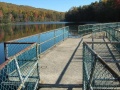
From parking lot, either cross the dam to hike in a clockwise direction or start at back of animal habitat by the aviary area.
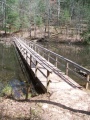
The park does an excellent job keeping this most popular trail open. The path is heavily used, but sometime covered with mulch.
The animal habitats are a hit with kids of all ages.
To get to the park a $5 gate fee is required. Yearly memberships can also be purchased.


