|
|
| (7 intermediate revisions by 2 users not shown) |
| Line 1: |
Line 1: |
| <!-- The following few lines create the "Infobox" table template. Please scroll down to edit the main content of the article.
| | {{Trail |
| | |Banner Image=File:Lakeside Trail - Bays Mountain Dam.jpg |
| | |Park=Bays Mountain Park |
| | |City=Kingsport |
| | |Land Owner=City of Kingsport |
| | |Trail Marking=Signs |
| | |Trail Use=Hiking, Geocaching |
| | |Trail Features=Lakes, Mountains |
| | |Difficulty Rating=Medium |
| | |Hike Time=1.5 hr |
| | |Trail Distance=2.316 mi |
| | |Round Trip Distance=2.316 mi |
| | |Trail Type=Loop |
| | |High Point=1,922 ft |
| | |Low Point=1,826 ft |
| | |Elevation Gain=143 ft |
| | |Elevation Loss=145 ft |
| | |Elevation Change Direction=Counter Clockwise |
| | |Parking location=36.50882, -82.60955 |
| | |Trailhead location=36.50889, -82.6114 |
| | }} |
| | {{Trail Map|Other Trails=Fire Tower Trail}} |
|
| |
|
| -->{{Infobox Trail
| | __TOC__ |
| | Image Name = Lakeside_Trail_-_Bays_Mountain_Dam.jpg
| |
| | Trail Number =
| |
| | Park = Bays Mountain Park
| |
| | City = Kingsport
| |
| | State = Tennessee
| |
| | Marking = Signs
| |
| | Trail Use = {{Hike}} {{Dogs}}
| |
| | Difficulty Rating = Easy
| |
| | Hike Time = 1.5 Hours
| |
| | Round Trip Distance = 2.35 Mi
| |
| | Trail Distance = 2.35 Mi
| |
| | Trail Type = Loop
| |
| | Elevation Gain = 775 Ft
| |
| | Elevation Loss = -775 Ft
| |
| | High Point = 1,974 Ft
| |
| | Parking coords = 36.508821,-82.609545
| |
| | Trailhead coords = 36.508894,-82.611401
| |
| | Medical = Kingsport, TN
| |
| }}<!--
| |
| | |
| End Infobox template table
| |
| | |
| -->{{Trail page needs
| |
| | Hide needs = Yes
| |
| | KML =
| |
| | Updated KML = Yes
| |
| | Detail route description =
| |
| | Photos =
| |
| | Winter photos =
| |
| | Remove prefix =
| |
| | Update infobox =
| |
| | Infobox data update =
| |
| | Trail pins =
| |
| | Other =
| |
| | Comment = Tweak KML to better match Map trail
| |
| | Date reviewed = 10/30/2015
| |
| }}<!--
| |
| | |
| Start of Main Page -->
| |
| == Trail Overview == | | == Trail Overview == |
| <!-- Enter a overview of the trail. What attracts you to this trail, points of interest, types of flowers, lakes, and peaks that you see along the way. --> | | <!-- Enter a overview of the trail. What attracts you to this trail, points of interest, types of flowers, lakes, and peaks that you see along the way. --> |
| Located at [[Bays Mountain Park]]. Very popular hiking loop trail around the reservoir. It connects with many other park trails, thus a common starting point. Officially takes 90 minutes on maintained path with moderate climbs and drops. A few benches are scattered along the trail. Points of interest include floating bridge, beaver activity (dams, lodges, and down/gnawed trees), lillypad pond, and the wolves and other animal habitats. Note red dirt from maroon shale in places. | | Located at [[Bays Mountain Park]]. Very popular hiking loop trail around the reservoir. It connects with many other park trails, thus a common starting point. Officially takes 90 minutes on maintained path with moderate climbs and drops. A few benches are scattered along the trail. Points of interest include floating bridge, beaver activity (dams, lodges, and down/gnawed trees), lilypad pond, and the wolves and other animal habitats. Note red dirt from maroon shale in places. |
|
| |
|
| == How to get there == | | == How to get there == |
| Line 51: |
Line 33: |
| == Route Description== | | == Route Description== |
| <!-- Detailed description of the route. Is there any side trails that are worth traveling? --> | | <!-- Detailed description of the route. Is there any side trails that are worth traveling? --> |
| This trail has connections to [[Trail connects to::Bays Ridge Road]], [[Trail connects to::Lake Road (Bays Mountain Park)|Lake Road]], [[Trail connects to::Cherry Knobs Trail]], [[Trail connects to::Sweet Gum Trail]], [[Trail connects to::Food Plot Road]], [[Trail connects to::Hemlock Trail]], [[Trail connects to::Holly Trail]], [[Trail connects to::Towhee Trail]], [[Trail connects to::Fern Trail]], and [[Trail connects to::Dolan Branch Trail]]. | | This trail has connections to [[Trail connects to::Bays Ridge Road]], [[Trail connects to::Lake Road (Bays Mountain Park)|Lake Road]], [[Trail connects to::Cherry Knobs]], [[Trail connects to::Sweet Gum Trail]], [[Trail connects to::Food Plot Road]], [[Trail connects to::Hemlock Trail]], [[Trail connects to::Holly Trail]], [[Trail connects to::Towhee Trail]], [[Trail connects to::Fern Trail]], and [[Trail connects to::Dolan Branch Trail]]. |
|
| |
|
| {| class="wikitable" border="1" | | {| class="wikitable" border="1" |
| Line 76: |
Line 58: |
| |- | | |- |
| |0.5 | | |0.5 |
| |Cherry Knobs Trail junction | | |Cherry Knobs junction |
| |1.9 | | |1.9 |
| |- | | |- |
| Line 123: |
Line 105: |
| <!-- Enter any additional information that doesn't fit an any other fields. Does this trail require any permits for overnight? parking? --> | | <!-- Enter any additional information that doesn't fit an any other fields. Does this trail require any permits for overnight? parking? --> |
|
| |
|
| == Maps ==
| | To get to the park a $5 gate fee is required. Yearly memberships can also be purchased. |
| <!-- You can place pictures, PDF's, links, or even create a Google map with your waypoints and place it here. -->
| |
| <display_map center="36.50903,-82.61255" type="terrain" zoom="15" width="auto" height="350" gkml="http://tehcc.org/clubwiki/kml/BMP_lakeside_trail.kml">
| |
| | |
| 36.508894,-82.611436~Beginning of dam bridge~ ~MarkerG.png
| |
| 36.50508,-82.61732~Floating bridge~[[Image:BMP Lakeside Trail floating bridge.JPG|150px]]~MarkerL.png
| |
| 36.50578,-82.61832~Junction with [[Cherry Knobs|Cherry Knobs]]~ ~MarkerT.png
| |
| 36.50596,-82.62100~Fixed bridge~ ~MarkerL.png
| |
| 36.50874,-82.62153~Fixed bridge~ ~MarkerL.png
| |
| 36.51039,-82.61639~Fixed bridge~ ~MarkerL.png
| |
| 36.51131,-82.61443~Fixed bridge~ ~MarkerL.png
| |
| 36.51267,-82.60963~No bridge at spring - pass around on uphill side~ ~MarkerJ.png
| |
| 36.51215,-82.60779~New trail bridge~ ~MarkerL.png
| |
| </display_map>
| |
|
| |
|
| == Photos == | | == Photos == |
| <gallery>
| | {{Park trail gallery|Trail={{PAGENAME}}}} |
| <!-- Place any pictures from this trail below. Ideally we would have a picture of the trailhead to help people know when they found it -->
| | {{Map Marker |
| <!-- Add a picture by typing Image:imagename.extension -->
| | |Icon Type=Point of interest |
| Image:Lakeside_Trailhead_from_Dam.jpg|Trailhead at reservoir dam | | |Marker Title=Beginning of dam bridge |
| Image:Lakeside_trail_-_evergreen_grove.jpg|Trail thru hemlock grove
| | |Marker Location=36.508894,-82.611436 |
| Image:Lakeside_Trail_-_former_avery_area.jpg|View across reservoir
| | }} |
| Image:Lakeside_Trail_-_Bays_Mountain_Dam.jpg|Crossing the dam
| | {{Map Marker |
| Image:BMP Lakeside Trail floating bridge.JPG|Floating bridge
| | |Icon Type=Trail bridge |
| <!-- Do not remove the end gallery code.-->
| | |Marker Title=Floating bridge |
| </gallery>
| | |Marker Description=[[Image:BMP Lakeside Trail floating bridge.JPG|150px]] |
| | | |Marker Location=36.50508,-82.61732 |
| <!-- Finally add the trail to any Categories it should belong to. Please keep the State category. To make a new category just type [[Category:mycategory]]. Keep in mind categories are case sensitive. -->
| | }} |
| [[Category:Tennessee]] [[Category:Kingsport]] [[Category:Bays Mountain Park]] [[Category:Easy]] [[Category:Dog Friendly]]
| | {{Map Marker |
| | |Icon Type=Trail sign |
| | |Marker Title=Junction with [[Cherry Knobs|Cherry Knobs]] |
| | |Marker Location=36.50578,-82.61832 |
| | }} |
| | {{Map Marker |
| | |Icon Type=Trail bridge |
| | |Marker Title=Fixed bridge |
| | |Marker Location=36.50596,-82.62100 |
| | }} |
| | {{Map Marker |
| | |Icon Type=Trail bridge |
| | |Marker Title=Fixed bridge |
| | |Marker Location=36.50874,-82.62153 |
| | }} |
| | {{Map Marker |
| | |Icon Type=Trail bridge |
| | |Marker Title=Fixed bridge |
| | |Marker Location=36.51039,-82.61639 |
| | }} |
| | {{Map Marker |
| | |Icon Type=Trail bridge |
| | |Marker Title=Fixed bridge |
| | |Marker Location=36.51131,-82.61443 |
| | }} |
| | {{Map Marker |
| | |Icon Type=Water crossing |
| | |Marker Title=No bridge at spring - pass around on uphill side |
| | |Marker Location=36.51267,-82.60963 |
| | }} |
| | {{Map Marker |
| | |Icon Type=Trail bridge |
| | |Marker Title=New trail bridge |
| | |Marker Location=36.51215,-82.60779 |
| | }} |
| Lakeside Trail
(log in to submit report)
|

|
|
|
| Park
|
Bays Mountain Park
|
| Land Owner
|
City of Kingsport
|
| Located
|
Kingsport, Tennessee
|
| Trail Marking
|
Signs
|
| Trail UseThings allowed to do on or near the trail
|
 
|
| FeaturesThings to see on or near the trail
|
 
|
| Difficulty Rating
|
Medium
|
| Hiking TimeTime from car and back. Includes any time hiking to access this trail.
|
1.5 hr0.0938 Days <br />90 Min <br /> round trip
|
| Distance:
|
2.316 mi3.727 km <br /> trailStrict non-repeating trail length / 2.316 mi3.727 km <br /> round tripTypical or shortest length from the car, hike the trail, and return to car
|
| Trail Type
|
Loop
|
| Low / High Point
|
1,826 ft608.667 Yards <br />556.565 Meters <br /> / 1,922 ft640.667 Yards <br />585.826 Meters <br />
|
| Elev. Gain/LossSee link for details of calculation. Gain/Loss is direction dependent.
|
143 ft43.586 Meters <br /> / (145 ft44.196 Meters <br />) – Counter Clockwise
|
| Trip ReportsFrom user "hiked it" submissions<br />Recent is within last 90 days
|
3 logged hikes (0 recent)
|
| NearbyWithin 5 mi<br />Click link to view list
|
32 trails / 36.2 mi of trail
|
| Parking
|
36° 30' 31.75" N, 82° 36' 34.38" W Map
|
| Trailhead
|
36° 30' 32.00" N, 82° 36' 41.04" W Map
|
Loading map... {"type":"ROADMAP","minzoom":false,"maxzoom":false,"types":["ROADMAP","SATELLITE","HYBRID","TERRAIN"],"mappingservice":"googlemaps3","width":"100%","height":"180px","centre":false,"title":"","label":"","icon":"","lines":[],"polygons":[],"circles":[],"rectangles":[],"copycoords":false,"static":false,"visitedicon":"","wmsoverlay":false,"zoom":8,"layers":[],"controls":[""],"zoomstyle":"DEFAULT","typestyle":"DEFAULT","autoinfowindows":false,"resizable":false,"kmlrezoom":false,"poi":true,"cluster":false,"clustergridsize":60,"clustermaxzoom":20,"clusterzoomonclick":true,"clusteraveragecenter":true,"clusterminsize":2,"imageoverlays":[],"kml":[],"gkml":[],"searchmarkers":"","fullscreen":false,"scrollwheelzoom":false,"locations":[{"text":"\u003Cb\u003E\u003Cdiv class=\"mw-parser-output\"\u003E\u003Cp\u003ELakeside Trail\n\u003C/p\u003E\u003C/div\u003E\u003C/b\u003E\u003Cdiv class=\"mw-parser-output\"\u003E\u003Cp\u003EMain Parking Location\n\u003C/p\u003E\u003C/div\u003E","title":"Lakeside Trail\n","link":"","lat":36.5088200000000000500222085975110530853271484375,"lon":-82.6095499999999987039700499735772609710693359375,"icon":""}]} |
| Show In Google Maps
|
Loading map...
{"format":"googlemaps3","type":"TERRAIN","minzoom":false,"maxzoom":false,"types":["SATELLITE","HYBRID","TERRAIN"],"limit":50,"offset":0,"link":"none","sort":[""],"order":[],"headers":"show","mainlabel":"","intro":"","outro":"","searchlabel":"... further results","default":"","import-annotation":false,"width":"auto","height":"600px","centre":false,"title":"","label":"","icon":"","lines":[],"polygons":[],"circles":[],"rectangles":[],"copycoords":false,"static":false,"visitedicon":"","wmsoverlay":false,"zoom":false,"layers":[],"controls":["pan","zoom","type","scale","streetview","rotate"],"zoomstyle":"DEFAULT","typestyle":"DEFAULT","autoinfowindows":false,"resizable":false,"kmlrezoom":true,"poi":true,"cluster":false,"clustergridsize":60,"clustermaxzoom":20,"clusterzoomonclick":true,"clusteraveragecenter":true,"clusterminsize":2,"imageoverlays":[],"kml":[],"gkml":["https://tehcc.org/clubwiki/images/Fire_Tower_Trail.kml","https://tehcc.org/clubwiki/images/Lakeside_Trail.kml"],"searchmarkers":"","fullscreen":false,"scrollwheelzoom":false,"showtitle":false,"hidenamespace":true,"template":"Map Balloon Template","userparam":"","activeicon":"","pagelabel":false,"ajaxcoordproperty":"","ajaxquery":"","locations":[{"text":"\u003Cp\u003E\u003Cb\u003E\u003Ca href=\"/wiki/Fire_Tower_Trail\" title=\"Fire Tower Trail\"\u003EFire Tower Trail\u003C/a\u003E\u003C/b\u003E\u003Cbr /\u003E\u003C/p\u003E\u003Chr /\u003E\u003Cp\u003E0.70\u0026#160;Mi (1.13\u0026#160;km)\u003Cbr /\u003EDifficulty: Medium\u003Cbr /\u003EMarking: Signs\u003C/p\u003E","title":"Fire Tower Trail","link":"","lat":36.51201999999999969759301166050136089324951171875,"lon":-82.61669000000000551153789274394512176513671875,"icon":"/clubwiki/images/MarkerT.png"},{"text":"\u003Cp\u003E\u003Cb\u003EGarden Mountain/Kingsport Lookout Tower\u003C/b\u003E\u003Cbr /\u003E\u003C/p\u003E\u003Chr /\u003E\u003Cp\u003E\u003Ca href=\"/wiki/File:BMP_Firetower_Trail_tower.jpg\" class=\"image\" title=\"Fire tower\"\u003E\u003Cimg alt=\"Fire tower\" src=\"/clubwiki/images/thumb/BMP_Firetower_Trail_tower.jpg/150px-BMP_Firetower_Trail_tower.jpg\" decoding=\"async\" width=\"150\" height=\"201\" srcset=\"/clubwiki/images/thumb/BMP_Firetower_Trail_tower.jpg/225px-BMP_Firetower_Trail_tower.jpg 1.5x, /clubwiki/images/BMP_Firetower_Trail_tower.jpg 2x\" data-file-width=\"300\" data-file-height=\"401\" /\u003E\u003C/a\u003E\u003C/p\u003E","title":"Fire Tower Trail","link":"","lat":36.5154500000000012960299500264227390289306640625,"lon":-82.6238000000000027966962079517543315887451171875,"icon":"/clubwiki/images/MarkerE.png"},{"text":"\u003Cp\u003E\u003Cb\u003EJunction with \u003Ca href=\"/wiki/Lake_Road_(Bays_Mountain_Park)\" title=\"Lake Road (Bays Mountain Park)\"\u003ELake Road\u003C/a\u003E\u003C/b\u003E\u003Cbr /\u003E\u003C/p\u003E\u003Chr /\u003E\u003Cp\u003EJunction with \u003Ca href=\"/wiki/Lake_Road_(Bays_Mountain_Park)\" title=\"Lake Road (Bays Mountain Park)\"\u003ELake Road\u003C/a\u003E\u003C/p\u003E","title":"Fire Tower Trail","link":"","lat":36.51201999999999969759301166050136089324951171875,"lon":-82.61669000000000551153789274394512176513671875,"icon":"/clubwiki/images/MarkerG.png"},{"text":"\u003Cp\u003E\u003Cb\u003E\u003Ca class=\"mw-selflink selflink\"\u003ELakeside Trail\u003C/a\u003E\u003C/b\u003E\u003Cbr /\u003E\u003C/p\u003E\u003Chr /\u003E\u003Cp\u003E2.32\u0026#160;Mi (3.73\u0026#160;km)\u003Cbr /\u003EDifficulty: Medium\u003Cbr /\u003EMarking: Signs\u003C/p\u003E","title":"Lakeside Trail","link":"","lat":36.50889000000000095269570010714232921600341796875,"lon":-82.611400000000003274180926382541656494140625,"icon":"/clubwiki/images/MarkerT.png"},{"text":"\u003Cp\u003E\u003Cb\u003EFixed bridge\u003C/b\u003E\u003Cbr /\u003E\u003C/p\u003E\u003Chr /\u003E\u003Cp\u003EFixed bridge\u003C/p\u003E","title":"Lakeside Trail","link":"","lat":36.51131000000000170757630257867276668548583984375,"lon":-82.614429999999998699422576464712619781494140625,"icon":"/clubwiki/images/MarkerL.png"},{"text":"\u003Cp\u003E\u003Cb\u003ENo bridge at spring - pass around on uphill side\u003C/b\u003E\u003Cbr /\u003E\u003C/p\u003E\u003Chr /\u003E\u003Cp\u003ENo bridge at spring - pass around on uphill side\u003C/p\u003E","title":"Lakeside Trail","link":"","lat":36.5126699999999999590727384202182292938232421875,"lon":-82.6096299999999956753526930697262287139892578125,"icon":"/clubwiki/images/MarkerJ.png"},{"text":"\u003Cp\u003E\u003Cb\u003EFixed bridge\u003C/b\u003E\u003Cbr /\u003E\u003C/p\u003E\u003Chr /\u003E\u003Cp\u003EFixed bridge\u003C/p\u003E","title":"Lakeside Trail","link":"","lat":36.510390000000001009539118967950344085693359375,"lon":-82.616389999999995552570908330380916595458984375,"icon":"/clubwiki/images/MarkerL.png"},{"text":"\u003Cp\u003E\u003Cb\u003EFloating bridge\u003C/b\u003E\u003Cbr /\u003E\u003C/p\u003E\u003Chr /\u003E\u003Cp\u003E\u003Ca href=\"/wiki/File:BMP_Lakeside_Trail_floating_bridge.JPG\" class=\"image\"\u003E\u003Cimg alt=\"BMP Lakeside Trail floating bridge.JPG\" src=\"/clubwiki/images/thumb/BMP_Lakeside_Trail_floating_bridge.JPG/150px-BMP_Lakeside_Trail_floating_bridge.JPG\" decoding=\"async\" width=\"150\" height=\"200\" srcset=\"/clubwiki/images/thumb/BMP_Lakeside_Trail_floating_bridge.JPG/225px-BMP_Lakeside_Trail_floating_bridge.JPG 1.5x, /clubwiki/images/thumb/BMP_Lakeside_Trail_floating_bridge.JPG/300px-BMP_Lakeside_Trail_floating_bridge.JPG 2x\" data-file-width=\"768\" data-file-height=\"1024\" /\u003E\u003C/a\u003E\u003C/p\u003E","title":"Lakeside Trail","link":"","lat":36.50507999999999952933649183250963687896728515625,"lon":-82.61732000000000653017195872962474822998046875,"icon":"/clubwiki/images/MarkerL.png"},{"text":"\u003Cp\u003E\u003Cb\u003EJunction with \u003Ca href=\"/wiki/Cherry_Knobs\" title=\"Cherry Knobs\"\u003ECherry Knobs\u003C/a\u003E\u003C/b\u003E\u003Cbr /\u003E\u003C/p\u003E\u003Chr /\u003E\u003Cp\u003EJunction with \u003Ca href=\"/wiki/Cherry_Knobs\" title=\"Cherry Knobs\"\u003ECherry Knobs\u003C/a\u003E\u003C/p\u003E","title":"Lakeside Trail","link":"","lat":36.5057800000000014506440493278205394744873046875,"lon":-82.6183199999999970941644278354942798614501953125,"icon":"/clubwiki/images/MarkerT.png"},{"text":"\u003Cp\u003E\u003Cb\u003EBeginning of dam bridge\u003C/b\u003E\u003Cbr /\u003E\u003C/p\u003E\u003Chr /\u003E\u003Cp\u003EBeginning of dam bridge\u003C/p\u003E","title":"Lakeside Trail","link":"","lat":36.50889399999999795909388922154903411865234375,"lon":-82.611435999999997648046701215207576751708984375,"icon":"/clubwiki/images/MarkerG.png"},{"text":"\u003Cp\u003E\u003Cb\u003EFixed bridge\u003C/b\u003E\u003Cbr /\u003E\u003C/p\u003E\u003Chr /\u003E\u003Cp\u003EFixed bridge\u003C/p\u003E","title":"Lakeside Trail","link":"","lat":36.5087400000000030786395655013620853424072265625,"lon":-82.6215300000000070212990976870059967041015625,"icon":"/clubwiki/images/MarkerL.png"},{"text":"\u003Cp\u003E\u003Cb\u003EFixed bridge\u003C/b\u003E\u003Cbr /\u003E\u003C/p\u003E\u003Chr /\u003E\u003Cp\u003EFixed bridge\u003C/p\u003E","title":"Lakeside Trail","link":"","lat":36.5059600000000017416823538951575756072998046875,"lon":-82.6209999999999951114659779705107212066650390625,"icon":"/clubwiki/images/MarkerL.png"},{"text":"\u003Cp\u003E\u003Cb\u003ENew trail bridge\u003C/b\u003E\u003Cbr /\u003E\u003C/p\u003E\u003Chr /\u003E\u003Cp\u003ENew trail bridge\u003C/p\u003E","title":"Lakeside Trail","link":"","lat":36.51214999999999832880348549224436283111572265625,"lon":-82.607789999999994279278325848281383514404296875,"icon":"/clubwiki/images/MarkerL.png"}]}
Download KML / Upload new version / KML File Page / Create Profile Chart / gpsvisualizer Map
Trail Overview[edit]
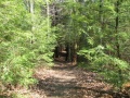
Located at Bays Mountain Park. Very popular hiking loop trail around the reservoir. It connects with many other park trails, thus a common starting point. Officially takes 90 minutes on maintained path with moderate climbs and drops. A few benches are scattered along the trail. Points of interest include floating bridge, beaver activity (dams, lodges, and down/gnawed trees), lilypad pond, and the wolves and other animal habitats. Note red dirt from maroon shale in places.
How to get there[edit]
From parking lot, either cross the dam to hike in a clockwise direction or start at back of animal habitat by the aviary area.
Route Description[edit]
This trail has connections to Bays Ridge Road, Lake Road, Cherry Knobs, Sweet Gum Trail, Food Plot Road, Hemlock Trail, Holly Trail, Towhee Trail, Fern Trail, and Dolan Branch Trail.
| Miles
|
Lakeside Trail
|
Miles
|
| 0.0
|
Dam, end nearest Nature Center
|
2.4
|
| 0.1
|
Dam, far end
|
2.3
|
| 0.2
|
Pine Trail junction
|
2.2
|
| 0.4
|
Floating Bridge
|
2.0
|
| 0.5
|
Cherry Knobs junction
|
1.9
|
| 1.1
|
Beaver Pond Bridge/ Sweet Gum Trail junction
|
1.3
|
| 1.6
|
Hemlock Tr./ (Fire Tower Trail) junction
|
0.8
|
| 1.7
|
Holly Trail/ Towhee Trail junction
|
0.7
|
| 1.8
|
Holly Trail junction
|
0.6
|
| 2.1
|
Fern Trail junction
|
0.3
|
| 2.3
|
Water Fowl Aviary/ Laurel Trail junction
|
0.1
|
| 2.4
|
Nature Center
|
0.0
|
Typical Conditions[edit]
The park does an excellent job keeping this most popular trail open. The path is heavily used, but sometime covered with mulch.
Regulations[edit]
NO BIKES!
Dogs are not allowed around the animal habitats, thus may have to skirt using Lake Road.
After the Hike[edit]
The animal habitats are a hit with kids of all ages.
Misc. Information[edit]
To get to the park a $5 gate fee is required. Yearly memberships can also be purchased.
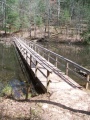
Floating bridge to cross lake on west end of loop
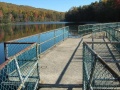
Dam crossing at Bays Mountain Park - Photo by Vic Hasler
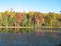
Look at reservoir from former avery area along Lakeside Trail - photo by Vic Hasler
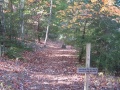
Lakeside trailhead from dam - Photo by Vic Hasler
Walking through evergreen grove on Lakeside Trail - photo by Vic Hasler