Lakeside Trail: Difference between revisions
m (Filled infobox variables) |
(Populated some fields before printing page for day hike) |
||
| Line 27: | Line 27: | ||
== Trail Overview == | == Trail Overview == | ||
<!-- Enter a overview of the trail. What attracts you to this trail, points of interest, types of flowers, lakes, and peaks that you see along the way. --> | <!-- Enter a overview of the trail. What attracts you to this trail, points of interest, types of flowers, lakes, and peaks that you see along the way. --> | ||
Very popular hiking loop trail around the reservoir. It connects with many other park trails, thus a common starting point. Officially takes 90 minutes on maintained path with moderate climbs and drops. A few benches are scattered along the trail. Points of interest include floating bridge, beaver activity (dams, lodges, and down/gnawed trees), lillypad pond, and the wolves and other animal habitats. Note red dirt from maroon shale in places. | Located at [[Bays Mountain Park]]. Very popular hiking loop trail around the reservoir. It connects with many other park trails, thus a common starting point. Officially takes 90 minutes on maintained path with moderate climbs and drops. A few benches are scattered along the trail. Points of interest include floating bridge, beaver activity (dams, lodges, and down/gnawed trees), lillypad pond, and the wolves and other animal habitats. Note red dirt from maroon shale in places. | ||
== How to get there == | == How to get there == | ||
<!-- Please enter detailed instruction on how to find the trail head. --> | <!-- Please enter detailed instruction on how to find the trail head. --> | ||
From parking lot, either cross the dam to hike in a clockwise direction or start at back of animal habitat by the aviary area. | |||
== Route Description== | == Route Description== | ||
| Line 92: | Line 92: | ||
== Typical Conditions == | == Typical Conditions == | ||
<!-- Typical conditions throughout the year of what to expect on the trail. Rocky, muddy, sandy, flowers, lots of downed trees? --> | <!-- Typical conditions throughout the year of what to expect on the trail. Rocky, muddy, sandy, flowers, lots of downed trees? --> | ||
The park does an excellent job keeping this most popular trail open. The path is heavily used, but sometime covered with mulch. | |||
==Fees, Permits, etc. == | ==Fees, Permits, etc. == | ||
<!-- Please list any Fees, Permits, Regulations, etc. that may be required on this trail.--> | <!-- Please list any Fees, Permits, Regulations, etc. that may be required on this trail.--> | ||
$3 fee to enter the park. | |||
<br>Dogs are not allowed around the animal habitats, thus may have to skirt using Lake Road. | |||
== After the Hike == | == After the Hike == | ||
<!-- Other things to check out while you're in the area. Restaurants, attractions, monuments, etc... --> | <!-- Other things to check out while you're in the area. Restaurants, attractions, monuments, etc... --> | ||
The animal habitats are a hit with kids of all ages. | |||
== Misc. Information == | == Misc. Information == | ||
| Line 120: | Line 122: | ||
Image:Lakeside_Trail_-_former_avery_area.jpg | Image:Lakeside_Trail_-_former_avery_area.jpg | ||
Image:Lakeside_Trail_-_Bays_Mountain_Dam.jpg | Image:Lakeside_Trail_-_Bays_Mountain_Dam.jpg | ||
<!-- Do not remove the end gallery code.--> | <!-- Do not remove the end gallery code.--> | ||
</gallery> | </gallery> | ||
<!-- Finally add the trail to any Categories it should belong to. Please keep the State category. To make a new category just type [[Category:mycategory]]. Keep in mind categories are case sensitive. --> | <!-- Finally add the trail to any Categories it should belong to. Please keep the State category. To make a new category just type [[Category:mycategory]]. Keep in mind categories are case sensitive. --> | ||
[[Category:Bays Mountain Park]] | [[Category:Tennessee]] [[Category:Kingsport]] [[Category:Bays Mountain Park]] [[Category:Easy]] [[Category:Dog Friendly]] | ||
Revision as of 07:35, 7 April 2011
| |||||||||||||||||||||||||||||||||||||

Trail Overview
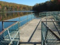
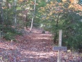
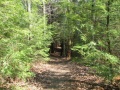
Located at Bays Mountain Park. Very popular hiking loop trail around the reservoir. It connects with many other park trails, thus a common starting point. Officially takes 90 minutes on maintained path with moderate climbs and drops. A few benches are scattered along the trail. Points of interest include floating bridge, beaver activity (dams, lodges, and down/gnawed trees), lillypad pond, and the wolves and other animal habitats. Note red dirt from maroon shale in places.
How to get there
From parking lot, either cross the dam to hike in a clockwise direction or start at back of animal habitat by the aviary area.
Route Description
| Miles | Lakeside Trail | Miles |
|---|---|---|
| 0.0 | Dam, end nearest Nature Center | 2.4 |
| 0.1 | Dam, far end | 2.3 |
| 0.2 | Pine Trail junction | 2.2 |
| 0.4 | Floating Bridge | 2.0 |
| 0.5 | Cherry Knobs Trail junction | 1.9 |
| 1.1 | Beaver Pond Bridge/ Sweet Gum Trail junction | 1.3 |
| 1.6 | Hemlock Tr./ (Firetower Trail) junction | 0.8 |
| 1.7 | Holly Trail/ Towhee Trail junction | 0.7 |
| 1.8 | Holly Trail junction | 0.6 |
| 2.1 | Fern Trail junction | 0.3 |
| 2.3 | Water Fowl Aviary/ Laurel Trail junction | 0.1 |
| 2.4 | Nature Center | 0.0 |
Typical Conditions
The park does an excellent job keeping this most popular trail open. The path is heavily used, but sometime covered with mulch.
Fees, Permits, etc.
$3 fee to enter the park.
Dogs are not allowed around the animal habitats, thus may have to skirt using Lake Road.
After the Hike
The animal habitats are a hit with kids of all ages.
Misc. Information
Maps
<googlemap lat="36.50803" lon="-82.61255" zoom="12" width="270" type="terrain" height="180" selector="no" controls="small"> 36.50803,-82.61255,Lakeside Trailhead at Dam </googlemap>
Photos
- Lakeside Trail - former avery area.jpg