Lakeshore: Difference between revisions
(Convert to new form format) |
(Update after hike) |
||
| (4 intermediate revisions by the same user not shown) | |||
| Line 1: | Line 1: | ||
{{Trail | {{Trail | ||
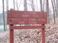
|Banner Image=File:WPSP Lakeshore Trail sign.JPG | |||
|Park=Warriors' Path State Park | |Park=Warriors' Path State Park | ||
|Trail Marking= | |Trail Marking=Black | ||
|Trail Use=Hiking,Fishing | |Trail Use=Hiking, Fishing | ||
|Trail Features=Rivers, Lakes | |||
|Difficulty Rating=Easy | |Difficulty Rating=Easy | ||
|Hike Time=15 min | |Hike Time=15 min | ||
| Line 13: | Line 15: | ||
|Elevation Loss=39 ft | |Elevation Loss=39 ft | ||
|Elevation Change Direction=East-to-West | |Elevation Change Direction=East-to-West | ||
|Parking location=36.49705,-82.47838 | |Parking location=36.49705, -82.47838 | ||
|Trailhead location=36.49705,-82.47838 | |Trailhead location=36.49705, -82.47838 | ||
}} | }} | ||
{{Trail Map|Other Trails=Riverbank}} | |||
__TOC__ | __TOC__ | ||
| Line 40: | Line 33: | ||
Path follows the north shoreline below the main park campground. There are no trail blazes, but the route is mostly clear. | Path follows the north shoreline below the main park campground. There are no trail blazes, but the route is mostly clear. | ||
<tab class=wikitable border=1 head=top> | |||
Mileage Lakeshore Trail | |||
0 Trailhead at campground sites B-34/35. Proceed downhill. | |||
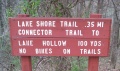
0.05 Down at lake shore where trail splits. Left continues Lakeshore Trail. Right begins [[Trail connects to::Connector|Connector Trail]]. | |||
0.15 Reach rocky point jutting into lake. Popular fishing spot. | |||
0.2 Cross wood trail bridge. | |||
0.35 Trailhead at boat launch. | |||
</tab> | |||
== Typical Conditions == | == Typical Conditions == | ||
| Line 79: | Line 60: | ||
== Photos == | == Photos == | ||
{{Park trail gallery|Trail={{PAGENAME}}}} | {{Park trail gallery|Trail={{PAGENAME}}}} | ||
{{Map Marker | |||
|Icon Type=Parking | |||
|Marker Title=Trailhead in park campground by sites B-34/35 | |||
|Marker Location=36.49705,-82.47838 | |||
}} | |||
{{Map Marker | |||
|Icon Type=Parking | |||
|Marker Title=Trailhead by boat launch | |||
|Marker Location=36.49870,-82.48225 | |||
}} | |||
{{Map Marker | |||
|Icon Type=Point of interest | |||
|Marker Title=Intersection Lakeshore and Connector Trails | |||
|Marker Description=[[Image:WPSP - Sign at Lakeshore and Connector Trail intersection.JPG|150px]] | |||
|Marker Location=36.49741,-82.47764 | |||
}} | |||
{{Map Marker | |||
|Icon Type=Point of interest | |||
|Marker Title=Fishing point | |||
|Marker Location=36.49787,-82.47906 | |||
}} | |||
{{Map Marker | |||
|Icon Type=Point of interest | |||
|Marker Title=Old dock | |||
|Marker Location=36.49850,-82.48113 | |||
}} | |||
{{Map Marker | |||
|Icon Type=Trail bridge | |||
|Marker Title=Trail bridge | |||
|Marker Location=36.49788,-82.47926 | |||
}} | |||
Latest revision as of 12:14, 29 December 2018
| Lakeshore (log in to submit report) | |
|---|---|

| |
| Park | Warriors' Path State Park |
| Located | Kingsport, TennesseeLocation inherited from associated park |
| Trail Marking | Black |
| Trail UseThings allowed to do on or near the trail |
|
| FeaturesThings to see on or near the trail |
|
| Difficulty Rating | Easy |
| Hiking TimeTime from car and back. Includes any time hiking to access this trail. | 15 min0.25 Hours <br />0.0156 Days <br /> round trip |
| Distance: | 0.31 mi0.499 km <br /> trailStrict non-repeating trail length / 2.232.23 mi <br />3.589 km <br /> round tripTypical or shortest length from the car, hike the trail, and return to car |
| Trail Type | In-and-Out |
| Low / High Point | 1,266 ft422 Yards <br />385.877 Meters <br /> / 1,307 ft435.667 Yards <br />398.374 Meters <br /> |
| Elev. Gain/LossSee link for details of calculation. Gain/Loss is direction dependent. | 0 ft0 Meters <br /> / (39 ft11.887 Meters <br />) – East-to-West |
| Trip ReportsFrom user "hiked it" submissions<br />Recent is within last 90 days | 2 logged hikes (0 recent) |
| NearbyWithin 5 mi<br />Click link to view list | 25 trails / 20.4 mi of trail |
| Parking | 36° 29' 49.38" N, 82° 28' 42.17" W Map |
| Trailhead | 36° 29' 49.38" N, 82° 28' 42.17" W Map |
|
| |
| Show In Google Maps | |
Download KML / Upload new version / KML File Page / Create Profile Chart / gpsvisualizer Map
Trail Overview[edit]
Located in Warriors Path State Park. A walk along the shore of Ft. Patrick Henry Lake/Holston River below the park campground.
How to get there[edit]
Directions to main entrance found on Warriors Path State Park webpage. There are two trailheads accessed through the park campground. One is on the east side of the boat launch; while the other is between campsites B-34 and B-35.
Route Description[edit]
Path follows the north shoreline below the main park campground. There are no trail blazes, but the route is mostly clear.
| Mileage Lakeshore Trail |
|---|
| 0 Trailhead at campground sites B-34/35. Proceed downhill. |
| 0.05 Down at lake shore where trail splits. Left continues Lakeshore Trail. Right begins Connector Trail. |
| 0.15 Reach rocky point jutting into lake. Popular fishing spot. |
| 0.2 Cross wood trail bridge. |
| 0.35 Trailhead at boat launch. |
Typical Conditions[edit]
Well worn path with detours as the trees fall and shoreline crumbles into the lake. The park has installed RR ties steps at several places.

Fees, Permits, etc.[edit]
No fee required. State license required for fishing.
Misc. Information[edit]
The park map brochure incorrectly states 0.5 mile trail length.
If you find a pair of handclippers along the trail, they're mine.
Photos[edit]
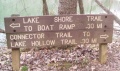
Trailhead sign
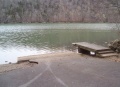
Boat Launch
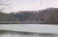
View of Fall Creek Road bridge
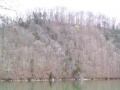
View of Lone Cedar Overlook on Devil's Backbone Trail
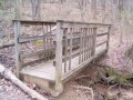
Trail bridge
Trailhead sign
Trailhead sign by boat launch


