|
|
| (11 intermediate revisions by 2 users not shown) |
| Line 1: |
Line 1: |
| <!-- The following few lines create the "Infobox" table template. Please scroll down to edit the main content of the article. -->
| | {{Trail |
| {{Infobox Trail | | |Banner Image=File:WPSP Lakeshore Trail sign.JPG |
| | Image Name = WPSP Lakeshore Trail sign.JPG
| | |Park=Warriors' Path State Park |
| | City = Kingsport
| | |Trail Marking=Black |
| | State = Tennessee
| | |Trail Use=Hiking, Fishing |
| | Marking = None
| | |Trail Features=Rivers, Lakes |
| | Trail Use = {{Hike}} {{Dogs}} {{Fishing}}
| | |Difficulty Rating=Easy |
| | Difficulty Rating = Easy
| | |Hike Time=15 min |
| | Hike Time = 0.25
| | |Trail Distance=0.31 mi |
| | Distance = 0.35
| | |Round Trip Distance=2.23 |
| | Elevation Gain = 22
| | |Trail Type=In-and-Out |
| | High Point = 1396
| | |High Point=1,307 ft |
| | Latitude = 36.49705
| | |Low Point=1,266 ft |
| | Longitude = -82.47838
| | |Elevation Gain=0 ft |
| | Medical = Indian Path Hospital
| | |Elevation Loss=39 ft |
| | |Elevation Change Direction=East-to-West |
| | |Parking location=36.49705, -82.47838 |
| | |Trailhead location=36.49705, -82.47838 |
| }} | | }} |
| <!-- End Infobox template table-->
| | {{Trail Map|Other Trails=Riverbank}} |
| | |
| <!-- Start of Main Page -->
| |
|
| |
|
| | __TOC__ |
| == Trail Overview == | | == Trail Overview == |
| <!-- Enter a overview of the trail. What attracts you to this trail, points of interest, types of flowers, lakes, and peaks that you see along the way. --> | | <!-- Enter a overview of the trail. What attracts you to this trail, points of interest, types of flowers, lakes, and peaks that you see along the way. --> |
| Line 31: |
Line 33: |
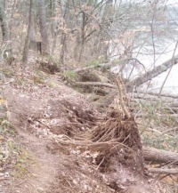
| Path follows the north shoreline below the main park campground. There are no trail blazes, but the route is mostly clear. | | Path follows the north shoreline below the main park campground. There are no trail blazes, but the route is mostly clear. |
|
| |
|
| {| class="wikitable" border="1"
| | <tab class=wikitable border=1 head=top> |
| |-
| | Mileage Lakeshore Trail |
| !Mileage
| | 0 Trailhead at campground sites B-34/35. Proceed downhill. |
| !Lakeshore Trail
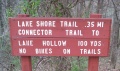
| | 0.05 Down at lake shore where trail splits. Left continues Lakeshore Trail. Right begins [[Trail connects to::Connector|Connector Trail]]. |
| |-
| | 0.15 Reach rocky point jutting into lake. Popular fishing spot. |
| |0.00
| | 0.2 Cross wood trail bridge. |
| |Trailhead at campground sites B-34/35. Proceed downhill.
| | 0.35 Trailhead at boat launch. |
| |-
| | </tab> |
| |0.05
| |
| |Down at lake shore where trail splits. Left continues Lakeshore Trail. Right begins [[WPSP Connector Trail]].
| |
| |-
| |
| |0.15
| |
| |Reach rocky point jutting into lake. Popular fishing spot.
| |
| |-
| |
| |0.20
| |
| |Cross wood trail bridge.
| |
| |-
| |
| |0.35
| |
| |Trailhead at boat launch.
| |
| |}
| |
|
| |
|
| == Typical Conditions == | | == Typical Conditions == |
| Line 61: |
Line 51: |
| <!-- Please list any Fees, Permits, Regulations, etc. that may be required on this trail.--> | | <!-- Please list any Fees, Permits, Regulations, etc. that may be required on this trail.--> |
| No fee required. State license required for fishing. | | No fee required. State license required for fishing. |
|
| |
| == After the Hike ==
| |
| <!-- Other things to check out while you're in the area. Restaurants, attractions, monuments, etc... -->
| |
|
| |
|
| |
|
| == Misc. Information == | | == Misc. Information == |
| <!-- Enter any additional information that doesn't fit an any other fields. Does this trail require any permits for overnight? parking? --> | | <!-- Enter any additional information that doesn't fit an any other fields. Does this trail require any permits for overnight? parking? --> |
| The park map brochure (link below) incorrectly states 0.5 mile trail length. | | The park map brochure incorrectly states 0.5 mile trail length. |
|
| |
|
| If you find a pair of handclippers along the trail, they're mine. | | If you find a pair of handclippers along the trail, they're mine. |
|
| |
| == Maps ==
| |
| <!-- You can place pictures, PDF's, links, or even create a Google map with your waypoints and place it here. -->
| |
| The path shown below in orange is this Lakeshore Trail. The section in dark blue is the [[WPSP Connector Trail]].
| |
|
| |
| <googlemap version="0.9" lat="36.498" lon="-82.481" type="terrain" zoom="15" width="400" height="350" scale="yes" controls="large" icons="http://tehcc.org/clubwiki/kml/marker{label}.png">
| |
| http://tehcc.org/clubwiki/kml/WPSP_Lakeshore_Trail.kml
| |
| http://tehcc.org/clubwiki/kml/WPSP_Connector_Trail.kml
| |
| (A) 36.49705,-82.47838
| |
| Trailhead in park campground by sites B-34/35
| |
| (A) 36.49870,-82.48225
| |
| Trailhead by boat launch
| |
| (G) 36.49741,-82.47764
| |
| Intersection Lakeshore and Connector Trails
| |
| [[Image:WPSP - Sign at Lakeshore and Connector Trail intersection.JPG|150px]]
| |
| 36.49787,-82.47906
| |
| Fishing point
| |
| 36.49850,-82.48113
| |
| Old dock
| |
| (L) 36.49788,-82.47926
| |
| Trail bridge
| |
| </googlemap>
| |
|
| |
| [http://www.state.tn.us/environment/parks/WarriorsPath/pdf/WPTRL.pdf State Park Map and Trail Brochure]
| |
|
| |
|
| == Photos == | | == Photos == |
| <gallery>
| | {{Park trail gallery|Trail={{PAGENAME}}}} |
| <!-- Place any pictures from this trail below. Ideally we would have a picture of the trailhead to help people know when they found it -->
| | {{Map Marker |
| <!-- Add a picture by typing Image:imagename.extension -->
| | |Icon Type=Parking |
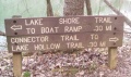
| Image:WPSP Lakeshore Trail sign2.JPG|Trailhead sign by boat launch
| | |Marker Title=Trailhead in park campground by sites B-34/35 |
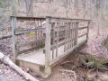
| Image:WPSP Lakeshore Trail bridge.JPG|Trail bridge on Lakeshore
| | |Marker Location=36.49705,-82.47838 |
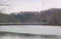
| Image:WPSP Lakeshore Trail - View of Fall Creek Road bridge.JPG|View of Fall Creek Road bridge
| | }} |
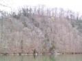
| Image:WPSP Lakeshore Trail - View of Lone Cedar Overlook.JPG|View of Lone Cedar Overlook on [[WPSP Devil's Backbone]] Trail
| | {{Map Marker |
| Image:WPSP - Sign at Lakeshore and Connector Trail intersection.JPG|Lakeshore and Connector Trail intersection | | |Icon Type=Parking |
| <!-- Do not remove the end gallery code.-->
| | |Marker Title=Trailhead by boat launch |
| </gallery>
| | |Marker Location=36.49870,-82.48225 |
| | | }} |
| <!-- Finally add the trail to any Categories it should belong to. Please keep the State category. To make a new category just type [[Category:mycategory]]. Keep in mind categories are case sensitive. Check here ClubWIKI:Categorization_Plan for our list of categories that we are using -->
| | {{Map Marker |
| [[Category:Tennessee]] [[Category:Warriors Path State Park]] [[Category:Kingsport]] [[Category:Dog Friendly]] [[Category:Easy]]
| | |Icon Type=Point of interest |
| | |Marker Title=Intersection Lakeshore and Connector Trails |
| | |Marker Description=[[Image:WPSP - Sign at Lakeshore and Connector Trail intersection.JPG|150px]] |
| | |Marker Location=36.49741,-82.47764 |
| | }} |
| | {{Map Marker |
| | |Icon Type=Point of interest |
| | |Marker Title=Fishing point |
| | |Marker Location=36.49787,-82.47906 |
| | }} |
| | {{Map Marker |
| | |Icon Type=Point of interest |
| | |Marker Title=Old dock |
| | |Marker Location=36.49850,-82.48113 |
| | }} |
| | {{Map Marker |
| | |Icon Type=Trail bridge |
| | |Marker Title=Trail bridge |
| | |Marker Location=36.49788,-82.47926 |
| | }} |
| Lakeshore
(log in to submit report)
|

|
|
|
| Park
|
Warriors' Path State Park
|
| Located
|
Kingsport, TennesseeLocation inherited from associated park
|
| Trail Marking
|
Black
|
| Trail UseThings allowed to do on or near the trail
|
 
|
| FeaturesThings to see on or near the trail
|
 
|
| Difficulty Rating
|
Easy
|
| Hiking TimeTime from car and back. Includes any time hiking to access this trail.
|
15 min0.25 Hours <br />0.0156 Days <br /> round trip
|
| Distance:
|
0.31 mi0.499 km <br /> trailStrict non-repeating trail length / 2.232.23 mi <br />3.589 km <br /> round tripTypical or shortest length from the car, hike the trail, and return to car
|
| Trail Type
|
In-and-Out
|
| Low / High Point
|
1,266 ft422 Yards <br />385.877 Meters <br /> / 1,307 ft435.667 Yards <br />398.374 Meters <br />
|
| Elev. Gain/LossSee link for details of calculation. Gain/Loss is direction dependent.
|
0 ft0 Meters <br /> / (39 ft11.887 Meters <br />) – East-to-West
|
| Trip ReportsFrom user "hiked it" submissions<br />Recent is within last 90 days
|
2 logged hikes (0 recent)
|
| NearbyWithin 5 mi<br />Click link to view list
|
25 trails / 20.4 mi of trail
|
| Parking
|
36° 29' 49.38" N, 82° 28' 42.17" W Map
|
| Trailhead
|
36° 29' 49.38" N, 82° 28' 42.17" W Map
|
Loading map... {"type":"ROADMAP","minzoom":false,"maxzoom":false,"types":["ROADMAP","SATELLITE","HYBRID","TERRAIN"],"mappingservice":"googlemaps3","width":"100%","height":"180px","centre":false,"title":"","label":"","icon":"","lines":[],"polygons":[],"circles":[],"rectangles":[],"copycoords":false,"static":false,"visitedicon":"","wmsoverlay":false,"zoom":8,"layers":[],"controls":[""],"zoomstyle":"DEFAULT","typestyle":"DEFAULT","autoinfowindows":false,"resizable":false,"kmlrezoom":false,"poi":true,"cluster":false,"clustergridsize":60,"clustermaxzoom":20,"clusterzoomonclick":true,"clusteraveragecenter":true,"clusterminsize":2,"imageoverlays":[],"kml":[],"gkml":[],"searchmarkers":"","fullscreen":false,"scrollwheelzoom":false,"locations":[{"text":"\u003Cb\u003E\u003Cdiv class=\"mw-parser-output\"\u003E\u003Cp\u003ELakeshore\n\u003C/p\u003E\u003C/div\u003E\u003C/b\u003E\u003Cdiv class=\"mw-parser-output\"\u003E\u003Cp\u003EMain Parking Location\n\u003C/p\u003E\u003C/div\u003E","title":"Lakeshore\n","link":"","lat":36.49705000000000154614099301397800445556640625,"lon":-82.4783800000000013596945791505277156829833984375,"icon":""}]} |
| Show In Google Maps
|
Loading map...
{"format":"googlemaps3","type":"TERRAIN","minzoom":false,"maxzoom":false,"types":["SATELLITE","HYBRID","TERRAIN"],"limit":50,"offset":0,"link":"none","sort":[""],"order":[],"headers":"show","mainlabel":"","intro":"","outro":"","searchlabel":"... further results","default":"","import-annotation":false,"width":"auto","height":"600px","centre":false,"title":"","label":"","icon":"","lines":[],"polygons":[],"circles":[],"rectangles":[],"copycoords":false,"static":false,"visitedicon":"","wmsoverlay":false,"zoom":false,"layers":[],"controls":["pan","zoom","type","scale","streetview","rotate"],"zoomstyle":"DEFAULT","typestyle":"DEFAULT","autoinfowindows":false,"resizable":false,"kmlrezoom":true,"poi":true,"cluster":false,"clustergridsize":60,"clustermaxzoom":20,"clusterzoomonclick":true,"clusteraveragecenter":true,"clusterminsize":2,"imageoverlays":[],"kml":[],"gkml":["https://tehcc.org/clubwiki/images/Lakeshore.kml","https://tehcc.org/clubwiki/images/Riverbank.kml"],"searchmarkers":"","fullscreen":false,"scrollwheelzoom":false,"showtitle":false,"hidenamespace":true,"template":"Map Balloon Template","userparam":"","activeicon":"","pagelabel":false,"ajaxcoordproperty":"","ajaxquery":"","locations":[{"text":"\u003Cp\u003E\u003Cb\u003E\u003Ca class=\"mw-selflink selflink\"\u003ELakeshore\u003C/a\u003E\u003C/b\u003E\u003Cbr /\u003E\u003C/p\u003E\u003Chr /\u003E\u003Cp\u003E0.31\u0026#160;Mi (0.50\u0026#160;km)\u003Cbr /\u003EDifficulty: Easy\u003Cbr /\u003EMarking: Black\u003C/p\u003E","title":"Lakeshore","link":"","lat":36.49705000000000154614099301397800445556640625,"lon":-82.4783800000000013596945791505277156829833984375,"icon":"/clubwiki/images/MarkerT.png"},{"text":"\u003Cp\u003E\u003Cb\u003ETrailhead by boat launch\u003C/b\u003E\u003Cbr /\u003E\u003C/p\u003E\u003Chr /\u003E\u003Cp\u003ETrailhead by boat launch\u003C/p\u003E","title":"Lakeshore","link":"","lat":36.4986999999999994770405464805662631988525390625,"lon":-82.482249999999993406163412146270275115966796875,"icon":"/clubwiki/images/MarkerA.png"},{"text":"\u003Cp\u003E\u003Cb\u003ETrailhead in park campground by sites B-34/35\u003C/b\u003E\u003Cbr /\u003E\u003C/p\u003E\u003Chr /\u003E\u003Cp\u003ETrailhead in park campground by sites B-34/35\u003C/p\u003E","title":"Lakeshore","link":"","lat":36.49705000000000154614099301397800445556640625,"lon":-82.4783800000000013596945791505277156829833984375,"icon":"/clubwiki/images/MarkerA.png"},{"text":"\u003Cp\u003E\u003Cb\u003EIntersection Lakeshore and Connector Trails\u003C/b\u003E\u003Cbr /\u003E\u003C/p\u003E\u003Chr /\u003E\u003Cp\u003E\u003Ca href=\"/wiki/File:WPSP_-_Sign_at_Lakeshore_and_Connector_Trail_intersection.JPG\" class=\"image\"\u003E\u003Cimg alt=\"WPSP - Sign at Lakeshore and Connector Trail intersection.JPG\" src=\"/clubwiki/images/thumb/WPSP_-_Sign_at_Lakeshore_and_Connector_Trail_intersection.JPG/150px-WPSP_-_Sign_at_Lakeshore_and_Connector_Trail_intersection.JPG\" decoding=\"async\" width=\"150\" height=\"88\" srcset=\"/clubwiki/images/thumb/WPSP_-_Sign_at_Lakeshore_and_Connector_Trail_intersection.JPG/225px-WPSP_-_Sign_at_Lakeshore_and_Connector_Trail_intersection.JPG 1.5x, /clubwiki/images/thumb/WPSP_-_Sign_at_Lakeshore_and_Connector_Trail_intersection.JPG/300px-WPSP_-_Sign_at_Lakeshore_and_Connector_Trail_intersection.JPG 2x\" data-file-width=\"448\" data-file-height=\"264\" /\u003E\u003C/a\u003E\u003C/p\u003E","title":"Lakeshore","link":"","lat":36.49741000000000212821760214865207672119140625,"lon":-82.4776399999999938472683425061404705047607421875,"icon":"/clubwiki/images/MarkerG.png"},{"text":"\u003Cp\u003E\u003Cb\u003ETrail bridge\u003C/b\u003E\u003Cbr /\u003E\u003C/p\u003E\u003Chr /\u003E\u003Cp\u003ETrail bridge\u003C/p\u003E","title":"Lakeshore","link":"","lat":36.49788000000000209865902434103190898895263671875,"lon":-82.4792599999999964666130836121737957000732421875,"icon":"/clubwiki/images/MarkerL.png"},{"text":"\u003Cp\u003E\u003Cb\u003EFishing point\u003C/b\u003E\u003Cbr /\u003E\u003C/p\u003E\u003Chr /\u003E\u003Cp\u003EFishing point\u003C/p\u003E","title":"Lakeshore","link":"","lat":36.49786999999999892452251515351235866546630859375,"lon":-82.4790600000000040381564758718013763427734375,"icon":"/clubwiki/images/MarkerG.png"},{"text":"\u003Cp\u003E\u003Cb\u003EOld dock\u003C/b\u003E\u003Cbr /\u003E\u003C/p\u003E\u003Chr /\u003E\u003Cp\u003EOld dock\u003C/p\u003E","title":"Lakeshore","link":"","lat":36.49849999999999994315658113919198513031005859375,"lon":-82.4811299999999931742422631941735744476318359375,"icon":"/clubwiki/images/MarkerG.png"},{"text":"\u003Cp\u003E\u003Cb\u003E\u003Ca href=\"/wiki/Riverbank\" title=\"Riverbank\"\u003ERiverbank\u003C/a\u003E\u003C/b\u003E\u003Cbr /\u003E\u003C/p\u003E\u003Chr /\u003E\u003Cp\u003E0.24\u0026#160;Mi (0.39\u0026#160;km)\u003Cbr /\u003EDifficulty: Easy\u003Cbr /\u003EMarking: Blue\u003C/p\u003E","title":"Riverbank","link":"","lat":36.4986999999999994770405464805662631988525390625,"lon":-82.482249999999993406163412146270275115966796875,"icon":"/clubwiki/images/MarkerT.png"},{"text":"\u003Cp\u003E\u003Cb\u003ETrailhead at Fall Creek Road\u003C/b\u003E\u003Cbr /\u003E\u003C/p\u003E\u003Chr /\u003E\u003Cp\u003ETrailhead at Fall Creek Road\u003C/p\u003E","title":"Riverbank","link":"","lat":36.50057000000000329009708366356790065765380859375,"lon":-82.4857999999999975671016727574169635772705078125,"icon":"/clubwiki/images/MarkerG.png"},{"text":"\u003Cp\u003E\u003Cb\u003ETrailhead by boat launch\u003C/b\u003E\u003Cbr /\u003E\u003C/p\u003E\u003Chr /\u003E\u003Cp\u003ETrailhead by boat launch\u003C/p\u003E","title":"Riverbank","link":"","lat":36.4986999999999994770405464805662631988525390625,"lon":-82.482249999999993406163412146270275115966796875,"icon":"/clubwiki/images/MarkerT.png"}]}
Download KML / Upload new version / KML File Page / Create Profile Chart / gpsvisualizer Map
Trail Overview[edit]
Located in Warriors Path State Park. A walk along the shore of Ft. Patrick Henry Lake/Holston River below the park campground.
How to get there[edit]
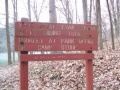
Directions to main entrance found on Warriors Path State Park webpage. There are two trailheads accessed through the park campground. One is on the east side of the boat launch; while the other is between campsites B-34 and B-35.
Route Description[edit]
Path follows the north shoreline below the main park campground. There are no trail blazes, but the route is mostly clear.
| Mileage Lakeshore Trail
|
| 0 Trailhead at campground sites B-34/35. Proceed downhill.
|
| 0.05 Down at lake shore where trail splits. Left continues Lakeshore Trail. Right begins Connector Trail.
|
| 0.15 Reach rocky point jutting into lake. Popular fishing spot.
|
| 0.2 Cross wood trail bridge.
|
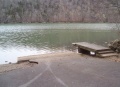
| 0.35 Trailhead at boat launch.
|
Typical Conditions[edit]
Well worn path with detours as the trees fall and shoreline crumbles into the lake. The park has installed RR ties steps at several places.
Fees, Permits, etc.[edit]
No fee required. State license required for fishing.
Misc. Information[edit]
The park map brochure incorrectly states 0.5 mile trail length.
If you find a pair of handclippers along the trail, they're mine.
View of Fall Creek Road bridge
View of Lone Cedar Overlook on Devil's Backbone Trail
Trailhead sign by boat launch