Lake Keokee Loop Trail: Difference between revisions
(→Photos) |
m (Text replacement - "http://tehcc.org/clubwiki/" to "https://tehcc.org/clubwiki/") |
||
| (16 intermediate revisions by 4 users not shown) | |||
| Line 1: | Line 1: | ||
<!-- The following few lines create the "Infobox" table template. Please scroll down to edit the main content of the article. --> | <!-- The following few lines create the "Infobox" table template. Please scroll down to edit the main content of the article. | ||
{{Infobox Trail | |||
| Image Name = | -->{{Infobox Trail | ||
| Image Name = Lake_Keokee.JPG | |||
| City = Appalachia | | City = Appalachia | ||
| State = Virginia | | State = Virginia | ||
| Marking = Yellow Blaze | |||
| Trail Use = {{Hike}} {{Dogs}} {{Fishing}} | | Trail Use = {{Hike}} {{Dogs}} {{Fishing}} | ||
| Difficulty Rating = Easy | | Difficulty Rating = Easy | ||
| Hike Time = 3 | | Hike Time = 3 | ||
| Distance = 3.7 | | Distance = 3.7 | ||
| Elevation Gain = | | Elevation Gain = 70 | ||
| High Point = 2, | | High Point = 2,315 | ||
| Latitude = | | Latitude = 36.849957 | ||
| Longitude = | | Longitude = -82.861717 | ||
| Medical = Big Stone Gap, VA | | Medical = Big Stone Gap, VA | ||
}}<!-- | |||
}} | |||
<!-- | |||
<!-- | End Infobox template table-->{{Trail page needs | ||
| Hide needs = | |||
| KML = | |||
| Updated KML = | |||
| Detail route description = Yes | |||
| Photos = | |||
| Winter photos = | |||
| Remove prefix = | |||
| Update infobox = Yes | |||
| Infobox data update = Yes | |||
| Trail pins = | |||
| Other = | |||
| Comment = Possibly turn into a park page and create referenced trail pages | |||
| Date reviewed = 10/29/2105 | |||
}}<!-- | |||
Start of Main Page --> | |||
== Trail Overview == | == Trail Overview == | ||
<!-- Enter overview of the trail. What attracts you to this trail, points of interest, types of flowers, lakes, and peaks that you see along the way. --> | <!-- Enter overview of the trail. What attracts you to this trail, points of interest, types of flowers, lakes, and peaks that you see along the way. --> | ||
Easy hike through | Easy hike through woodlands around the manmade lake. Good for bird watching or wildflowers in season. | ||
== How to get there == | == How to get there == | ||
| Line 37: | Line 47: | ||
#Turn left/east onto SR-623 for half mile. | #Turn left/east onto SR-623 for half mile. | ||
#Turn left/east onto SR-876 and proceed one mile to Lake Keokee Recreation Area. | #Turn left/east onto SR-876 and proceed one mile to Lake Keokee Recreation Area. | ||
Trailheads at parking lot are NOT marked. Heading west immediately crosses a bridge, while the east side loop begin with the walkway to the observation pier. | |||
== Route Description== | == Route Description== | ||
<!-- Detailed description of the route. Is there any side trails that are worth traveling? --> | <!-- Detailed description of the route. Is there any side trails that are worth traveling? --> | ||
Lightly used, hardpacked trail around the lake – crossing the dam. In June, flame azaleas can be seen in bloom. | Lightly used, hardpacked trail winding around the lake – crossing the dam. In June, flame azaleas can be seen in bloom. | ||
Olinger Gap Trail (1 mile) connects the Keokee Lake Loop Trail to the Stone Mountain Trail. | Olinger Gap Trail (1 mile) connects the Keokee Lake Loop Trail to the Stone Mountain Trail. | ||
== Typical Conditions == | == Typical Conditions == | ||
<!-- Typical conditions throughout the year of what to expect on the trail. | <!-- Typical conditions throughout the year of what to expect on the trail. --> | ||
The district has cleared the trail from severe damaged caused by a December 2009 ice storm. The trail sometimes follows old fire roads or wanders just above the lake. There are some dense rhododendron growths. | |||
==Fees, Permits, etc. == | ==Fees, Permits, etc. == | ||
<!-- Please list any Fees, Permits, Regulations, etc. that may be required on this trail.--> | <!-- Please list any Fees, Permits, Regulations, etc. that may be required on this trail.--> | ||
Open year-round. No fees or permits are required for day hiking. Managed by the Clinch Ranger District (Wise, VA) Tel: 276- | Open year-round - 6AM to 10PM. No fees or permits are required for day hiking. Managed by the Clinch Ranger District (Wise, VA) Tel: 276-679-8370 (M-F 8AM-4:30PM) | ||
== After the Hike == | == After the Hike == | ||
<!-- Anywhere interesting to stop by since you're in the area!! --> | <!-- Anywhere interesting to stop by since you're in the area!! --> | ||
== Misc. Information == | |||
<!-- Enter any additional information that doesn't fit an any other fields. Does this trail require any permits for overnight? parking? --> | |||
Forest Service [http://www.fs.usda.gov/recarea/gwj/recreation/hiking/recarea/?recid=73793&actid=50 usda.gov trail page] and [http://www.fs.fed.us/outernet/r8/gwj/clinch/recreation/hiking/lake_keokee_trail.shtml fed.us trail webpage] | |||
Lake Keokee was created by damming the Powell River in 1975 to provide recreation opportunities. No gasoline motors are allowed on the lake, so it is quiet as fishing is done from canoes or flatboats. | |||
== Maps == | == Maps == | ||
<!-- You can place pictures, PDF's, links, or even create a Google map with your waypoints and place it here. --> | <!-- You can place pictures, PDF's, links, or even create a Google map with your waypoints and place it here. --> | ||
< | <display_map center="36.849957,-82.861717" type="terrain" zoom="15" height="500" width="auto" gkml="https://tehcc.org/clubwiki/kml/Lake%20Keokee%20Trail.kml, | ||
https://tehcc.org/clubwiki/kml/Olinger_Gap_Trail_partial.kml"> | |||
36.85460,-82.86300~Parking at recreation area~ ~MarkerA.png | |||
36.84545,-82.86679~Lake Keokee Dam~[[Image:Lake Keokee dam.JPG|150px]]~MarkerG.png | |||
</display_map> | |||
== Photos == | |||
<gallery> | |||
</ | <!-- Place any pictures from this trail below. Add a picture by typing Image:imagename.extension --> | ||
Image:Lake Keokee from dam.JPG|View of Lake Keokee from dam | |||
Image:Double yellow blaze.JPG|Watch carefully for this sharp turn | |||
<!-- Do not remove the end gallery code.--> | |||
</gallery> | |||
<!-- Finally add the trail to any Categories it should belong to. Please keep the State category. To make a new category just type [[Category:mycategory]]. Keep in mind categories are case sensitive. --> | |||
[[Category:Virginia]] [[Category:Easy]] [[Category:Fishing]] [[Category:Dog Friendly]] | |||
Latest revision as of 12:12, 7 January 2023
| |||||||||||||||||||||||||||||||||||||

Trail Overview[edit]
Easy hike through woodlands around the manmade lake. Good for bird watching or wildflowers in season.
How to get there[edit]
From Kingsport, TN
- North on US-23 to Big Stone Gap.
- Wander thru town on US-23 and continue to Appalachia.
- Left/north onto VA-68 (Inman Street) for six miles.
- Continue straight onto SR-606 a couple of miles.
- Turn left/east onto SR-623 for half mile.
- Turn left/east onto SR-876 and proceed one mile to Lake Keokee Recreation Area.
Trailheads at parking lot are NOT marked. Heading west immediately crosses a bridge, while the east side loop begin with the walkway to the observation pier.
Route Description[edit]
Lightly used, hardpacked trail winding around the lake – crossing the dam. In June, flame azaleas can be seen in bloom.
Olinger Gap Trail (1 mile) connects the Keokee Lake Loop Trail to the Stone Mountain Trail.
Typical Conditions[edit]
The district has cleared the trail from severe damaged caused by a December 2009 ice storm. The trail sometimes follows old fire roads or wanders just above the lake. There are some dense rhododendron growths.
Fees, Permits, etc.[edit]
Open year-round - 6AM to 10PM. No fees or permits are required for day hiking. Managed by the Clinch Ranger District (Wise, VA) Tel: 276-679-8370 (M-F 8AM-4:30PM)
After the Hike[edit]
Misc. Information[edit]
Forest Service usda.gov trail page and fed.us trail webpage
Lake Keokee was created by damming the Powell River in 1975 to provide recreation opportunities. No gasoline motors are allowed on the lake, so it is quiet as fishing is done from canoes or flatboats.
Maps[edit]
Photos[edit]
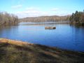
View of Lake Keokee from dam
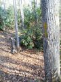
Watch carefully for this sharp turn

