Lake Hollow: Difference between revisions
(Copying template from Holston Bluffs trail) |
m (Text replacement - "http://tehcc.org/clubwiki/" to "https://tehcc.org/clubwiki/") |
||
| (24 intermediate revisions by 3 users not shown) | |||
| Line 1: | Line 1: | ||
{{Trail | |||
{{ | |Banner Image=File:WPSP Lake Hollow Trail sign1.JPG | ||
|Park=Warriors' Path State Park | |||
|Trail Marking=None | |||
|Trail Use=Hiking, Fishing | |||
|Trail Features=Rivers, Lakes | |||
|Difficulty Rating=Easy | |||
|Hike Time=30 min | |||
|Trail Distance=0.56 Mi | |||
|Round Trip Distance=1.0 Mi | |||
|Trail Type=In-and-Out | |||
|High Point=1,335 ft | |||
|Low Point=1,265 ft | |||
|Elevation Gain=63 ft | |||
|Elevation Loss=46 ft | |||
|Elevation Change Direction=West-to-East | |||
|Parking location=36.49686, -82.48409 | |||
36. | |Trailhead location=36.49686, -82.48409 | ||
}} | }} | ||
< | <display_map center="36.497,-82.483" type="terrain" zoom="15" width="auto" height="550" kml="https://tehcc.org/clubwiki/kml/WPSP_Lake_Hollow_Trail.kml,https://tehcc.org/clubwiki/kml/WPSP_Connector_Trail.kml"> | ||
36.49686,-82.48409~Trailhead by park campground entrance~ ~MarkerA.png | |||
< | 36.49587,-82.47730~Trailhead by grey water disposal area~ ~MarkerA.png | ||
36.49529,-82.47646~Intersection Lake Hollow and Connector Trails~ ~MarkerG.png | |||
</display_map> | |||
The path shown below in red is this Lake Hollow Trail. The section in dark blue is the [[Connector|Connector Trail]]. | |||
__TOC__ | |||
== Trail Overview == | == Trail Overview == | ||
<!-- Enter a overview of the trail. What attracts you to this trail, points of interest, types of flowers, lakes, and peaks that you see along the way. --> | <!-- Enter a overview of the trail. What attracts you to this trail, points of interest, types of flowers, lakes, and peaks that you see along the way. --> | ||
Located in [[Warriors Path State Park]]. Short | Located in [[Warriors Path State Park]]. Short walk along the shore of Ft. Patrick Henry Lake looking towards Duck Island. | ||
== How to get there == | == How to get there == | ||
<!-- Please enter detailed instruction on how to find the trail head. --> | <!-- Please enter detailed instruction on how to find the trail head. --> | ||
Directions to main entrance found on [[Warriors Path State Park]] webpage. | Directions to main entrance found on [[Warriors Path State Park]] webpage. There are two trailheads. One is by the entrance to the park campground; while the other is by the grey water disposal station back in the campground. | ||
== Route Description== | == Route Description== | ||
<!-- Detailed description of the route. Is there any side trails that are worth traveling? --> | <!-- Detailed description of the route. Is there any side trails that are worth traveling? --> | ||
Path follows the south shoreline below the main park campground. There are no trail blazes, but the route is clear. | |||
<tab class=wikitable border=1 head=top> | |||
Mileage Lake Hollow Trail | |||
0 Trailhead at campground entrance. Ulster Project Peace Bench also here. Proceed down trail and RR tie steps. | |||
0.1 Path veers left as shoreline reached at bottom of steps. | |||
0.4 Reach point jutting into lake and covered with kudzu. | |||
0.5 Split. No sign. Left Lake Hollow Trail proceed uphill to trailhead. Right begins [[Connector|Connector Trail]]. | |||
0.6 Trailhead at grey water disposal station. | |||
</tab> | |||
| | |||
== Typical Conditions == | == Typical Conditions == | ||
<!-- Typical conditions throughout the year of what to expect on the trail. Rocky, muddy, sandy, flowers, lots of downed trees? --> | <!-- Typical conditions throughout the year of what to expect on the trail. Rocky, muddy, sandy, flowers, lots of downed trees? --> | ||
Well worn path with detours as the trees fall and shoreline crumbles into the lake. The park has installed RR ties steps at several places. | |||
==Fees, Permits, etc. == | ==Fees, Permits, etc. == | ||
<!-- Please list any Fees, Permits, Regulations, etc. that may be required on this trail.--> | <!-- Please list any Fees, Permits, Regulations, etc. that may be required on this trail.--> | ||
No fee required. | No fee required. | ||
== Misc. Information == | == Misc. Information == | ||
<!-- Enter any additional information that doesn't fit an any other fields. Does this trail require any permits for overnight? parking? --> | <!-- Enter any additional information that doesn't fit an any other fields. Does this trail require any permits for overnight? parking? --> | ||
The park map brochure (link below) | The park map brochure (link below) incorrectly displays where the "Connector Trail" splits off. | ||
At the trailhead by the campground entrance, there is a set of benches placed by the Ulster Project, which works with Northern Ireland teenagers to enable leadership and reconciliation between Protestants and Catholics. The program hosts the youth in US cities during July to work on a series of projects and tour the area. These benches were placed in the 90s. For more information see [https://en.wikipedia.org/wiki/Ulster_Project Ulster Project] | |||
Another set of peace benches over along [[Fall Creek Loop|Fall Creek Loop Trail]]. | |||
== Photos == | == Photos == | ||
{{Park trail gallery|Trail={{PAGENAME}}}} | |||
Latest revision as of 12:12, 7 January 2023
| Lake Hollow (log in to submit report) | |
|---|---|

| |
| Park | Warriors' Path State Park |
| Located | Kingsport, TennesseeLocation inherited from associated park |
| Trail Marking | None |
| Trail UseThings allowed to do on or near the trail |
|
| FeaturesThings to see on or near the trail |
|
| Difficulty Rating | Easy |
| Hiking TimeTime from car and back. Includes any time hiking to access this trail. | 30 min0.5 Hours <br />0.0313 Days <br /> round trip |
| Distance: | 0.56 Mi0.901 km <br /> trailStrict non-repeating trail length / 1.0 Mi1.609 km <br /> round tripTypical or shortest length from the car, hike the trail, and return to car |
| Trail Type | In-and-Out |
| Low / High Point | 1,265 ft421.667 Yards <br />385.572 Meters <br /> / 1,335 ft445 Yards <br />406.908 Meters <br /> |
| Elev. Gain/LossSee link for details of calculation. Gain/Loss is direction dependent. | 63 ft19.202 Meters <br /> / (46 ft14.021 Meters <br />) – West-to-East |
| Trip ReportsFrom user "hiked it" submissions<br />Recent is within last 90 days | 2 logged hikes (0 recent) |
| NearbyWithin 5 mi<br />Click link to view list | 24 trails / 19.0 mi of trail |
| Parking | 36° 29' 48.70" N, 82° 29' 2.72" W Map |
| Trailhead | 36° 29' 48.70" N, 82° 29' 2.72" W Map |
|
| |
| Show In Google Maps | |
The path shown below in red is this Lake Hollow Trail. The section in dark blue is the Connector Trail.
Trail Overview[edit]
Located in Warriors Path State Park. Short walk along the shore of Ft. Patrick Henry Lake looking towards Duck Island.
How to get there[edit]
Directions to main entrance found on Warriors Path State Park webpage. There are two trailheads. One is by the entrance to the park campground; while the other is by the grey water disposal station back in the campground.
Route Description[edit]
Path follows the south shoreline below the main park campground. There are no trail blazes, but the route is clear.
| Mileage Lake Hollow Trail |
|---|
| 0 Trailhead at campground entrance. Ulster Project Peace Bench also here. Proceed down trail and RR tie steps. |
| 0.1 Path veers left as shoreline reached at bottom of steps. |
| 0.4 Reach point jutting into lake and covered with kudzu. |
| 0.5 Split. No sign. Left Lake Hollow Trail proceed uphill to trailhead. Right begins Connector Trail. |
| 0.6 Trailhead at grey water disposal station. |
Typical Conditions[edit]
Well worn path with detours as the trees fall and shoreline crumbles into the lake. The park has installed RR ties steps at several places.
Fees, Permits, etc.[edit]
No fee required.
Misc. Information[edit]
The park map brochure (link below) incorrectly displays where the "Connector Trail" splits off.
At the trailhead by the campground entrance, there is a set of benches placed by the Ulster Project, which works with Northern Ireland teenagers to enable leadership and reconciliation between Protestants and Catholics. The program hosts the youth in US cities during July to work on a series of projects and tour the area. These benches were placed in the 90s. For more information see Ulster Project
Another set of peace benches over along Fall Creek Loop Trail.
Photos[edit]
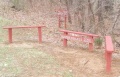
Ulster Project Peach Bench
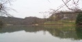
View towards Duck Island
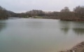
View towards main boat ramp
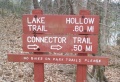
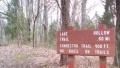
Trail Sign
Sign at grey water disposal station


