Loading map...
{"format":"googlemaps3","type":"TERRAIN","minzoom":false,"maxzoom":false,"types":["SATELLITE","HYBRID","TERRAIN"],"limit":50,"offset":0,"link":"none","sort":[""],"order":[],"headers":"show","mainlabel":"","intro":"","outro":"","searchlabel":"... further results","default":"","import-annotation":false,"width":"auto","height":"600px","centre":false,"title":"","label":"","icon":"","lines":[],"polygons":[],"circles":[],"rectangles":[],"copycoords":false,"static":false,"visitedicon":"","wmsoverlay":false,"zoom":false,"layers":[],"controls":["pan","zoom","type","scale","streetview","rotate"],"zoomstyle":"DEFAULT","typestyle":"DEFAULT","autoinfowindows":false,"resizable":false,"kmlrezoom":true,"poi":true,"cluster":false,"clustergridsize":60,"clustermaxzoom":20,"clusterzoomonclick":true,"clusteraveragecenter":true,"clusterminsize":2,"imageoverlays":[],"kml":[],"gkml":["https://tehcc.org/clubwiki/images/Fire_Tower_Trail.kml","https://tehcc.org/clubwiki/images/Jones_Road.kml"],"searchmarkers":"","fullscreen":false,"scrollwheelzoom":false,"showtitle":false,"hidenamespace":true,"template":"Map Balloon Template","userparam":"","activeicon":"","pagelabel":false,"ajaxcoordproperty":"","ajaxquery":"","locations":[{"text":"\u003Cp\u003E\u003Cb\u003E\u003Ca href=\"/wiki/Fire_Tower_Trail\" title=\"Fire Tower Trail\"\u003EFire Tower Trail\u003C/a\u003E\u003C/b\u003E\u003Cbr /\u003E\u003C/p\u003E\u003Chr /\u003E\u003Cp\u003E0.70\u0026#160;Mi (1.13\u0026#160;km)\u003Cbr /\u003EDifficulty: Medium\u003Cbr /\u003EMarking: Signs\u003C/p\u003E","title":"Fire Tower Trail","link":"","lat":36.51201999999999969759301166050136089324951171875,"lon":-82.61669000000000551153789274394512176513671875,"icon":"/clubwiki/images/MarkerT.png"},{"text":"\u003Cp\u003E\u003Cb\u003EGarden Mountain/Kingsport Lookout Tower\u003C/b\u003E\u003Cbr /\u003E\u003C/p\u003E\u003Chr /\u003E\u003Cp\u003E\u003Ca href=\"/wiki/File:BMP_Firetower_Trail_tower.jpg\" class=\"image\" title=\"Fire tower\"\u003E\u003Cimg alt=\"Fire tower\" src=\"/clubwiki/images/thumb/BMP_Firetower_Trail_tower.jpg/150px-BMP_Firetower_Trail_tower.jpg\" decoding=\"async\" width=\"150\" height=\"201\" srcset=\"/clubwiki/images/thumb/BMP_Firetower_Trail_tower.jpg/225px-BMP_Firetower_Trail_tower.jpg 1.5x, /clubwiki/images/BMP_Firetower_Trail_tower.jpg 2x\" data-file-width=\"300\" data-file-height=\"401\" /\u003E\u003C/a\u003E\u003C/p\u003E","title":"Fire Tower Trail","link":"","lat":36.5154500000000012960299500264227390289306640625,"lon":-82.6238000000000027966962079517543315887451171875,"icon":"/clubwiki/images/MarkerE.png"},{"text":"\u003Cp\u003E\u003Cb\u003EJunction with \u003Ca href=\"/wiki/Lake_Road_(Bays_Mountain_Park)\" title=\"Lake Road (Bays Mountain Park)\"\u003ELake Road\u003C/a\u003E\u003C/b\u003E\u003Cbr /\u003E\u003C/p\u003E\u003Chr /\u003E\u003Cp\u003EJunction with \u003Ca href=\"/wiki/Lake_Road_(Bays_Mountain_Park)\" title=\"Lake Road (Bays Mountain Park)\"\u003ELake Road\u003C/a\u003E\u003C/p\u003E","title":"Fire Tower Trail","link":"","lat":36.51201999999999969759301166050136089324951171875,"lon":-82.61669000000000551153789274394512176513671875,"icon":"/clubwiki/images/MarkerG.png"},{"text":"\u003Cp\u003E\u003Cb\u003E\u003Ca class=\"mw-selflink selflink\"\u003EJones Road\u003C/a\u003E\u003C/b\u003E\u003Cbr /\u003E\u003C/p\u003E\u003Chr /\u003E\u003Cp\u003E0.93\u0026#160;Mi (1.49\u0026#160;km)\u003Cbr /\u003EDifficulty: Medium\u003Cbr /\u003EMarking: Signs\u003C/p\u003E","title":"Jones Road","link":"","lat":36.49602999999999752844814793206751346588134765625,"lon":-82.6315900000000027603164198808372020721435546875,"icon":"/clubwiki/images/MarkerT.png"},{"text":"\u003Cp\u003E\u003Cb\u003EJunction with \u003Ca href=\"/wiki/Front_Hollow_Road\" title=\"Front Hollow Road\"\u003EFront Hollow Road\u003C/a\u003E by \"Big Oak\"\u003C/b\u003E\u003Cbr /\u003E\u003C/p\u003E\u003Chr /\u003E\u003Cp\u003E\u003Ca href=\"/wiki/File:BMP_Big_Oak.JPG\" class=\"image\"\u003E\u003Cimg alt=\"BMP Big Oak.JPG\" src=\"/clubwiki/images/thumb/BMP_Big_Oak.JPG/150px-BMP_Big_Oak.JPG\" decoding=\"async\" width=\"150\" height=\"200\" srcset=\"/clubwiki/images/thumb/BMP_Big_Oak.JPG/225px-BMP_Big_Oak.JPG 1.5x, /clubwiki/images/thumb/BMP_Big_Oak.JPG/300px-BMP_Big_Oak.JPG 2x\" data-file-width=\"768\" data-file-height=\"1024\" /\u003E\u003C/a\u003E\u003C/p\u003E","title":"Jones Road","link":"","lat":36.49602999999999752844814793206751346588134765625,"lon":-82.6315799999999995861799106933176517486572265625,"icon":"/clubwiki/images/MarkerT.png"},{"text":"\u003Cp\u003E\u003Cb\u003EParking at Bays Mountain Trail Road\u003C/b\u003E\u003Cbr /\u003E\u003C/p\u003E\u003Chr /\u003E\u003Cp\u003E\u003Ca href=\"/wiki/File:Jones_Road_Trailhead.jpg\" class=\"image\"\u003E\u003Cimg alt=\"Jones Road Trailhead.jpg\" src=\"/clubwiki/images/thumb/Jones_Road_Trailhead.jpg/150px-Jones_Road_Trailhead.jpg\" decoding=\"async\" width=\"150\" height=\"113\" srcset=\"/clubwiki/images/thumb/Jones_Road_Trailhead.jpg/225px-Jones_Road_Trailhead.jpg 1.5x, /clubwiki/images/thumb/Jones_Road_Trailhead.jpg/300px-Jones_Road_Trailhead.jpg 2x\" data-file-width=\"1200\" data-file-height=\"900\" /\u003E\u003C/a\u003E\u003C/p\u003E","title":"Jones Road","link":"","lat":36.49392374010000139605836011469364166259765625,"lon":-82.6241475613999938332199235446751117706298828125,"icon":"/clubwiki/images/MarkerA.png"},{"text":"\u003Cp\u003E\u003Cb\u003EJunction with \u003Ca href=\"/wiki/Bays_Ridge_Trail\" title=\"Bays Ridge Trail\"\u003EBays Ridge Trail\u003C/a\u003E\u003C/b\u003E\u003Cbr /\u003E\u003C/p\u003E\u003Chr /\u003E\u003Cp\u003E\u003Ca href=\"/wiki/File:Jones_Road_Junction_02.jpg\" class=\"image\"\u003E\u003Cimg alt=\"Jones Road Junction 02.jpg\" src=\"/clubwiki/images/thumb/Jones_Road_Junction_02.jpg/150px-Jones_Road_Junction_02.jpg\" decoding=\"async\" width=\"150\" height=\"113\" srcset=\"/clubwiki/images/thumb/Jones_Road_Junction_02.jpg/225px-Jones_Road_Junction_02.jpg 1.5x, /clubwiki/images/thumb/Jones_Road_Junction_02.jpg/300px-Jones_Road_Junction_02.jpg 2x\" data-file-width=\"1200\" data-file-height=\"900\" /\u003E\u003C/a\u003E\u003C/p\u003E","title":"Jones Road","link":"","lat":36.49210000000000064801497501321136951446533203125,"lon":-82.6337199999999967303665471263229846954345703125,"icon":"/clubwiki/images/MarkerT.png"},{"text":"\u003Cp\u003E\u003Cb\u003EArrives at ridgeline with \u003Ca href=\"/wiki/Bays_Ridge_Trail\" title=\"Bays Ridge Trail\"\u003EBays Ridge Trail\u003C/a\u003E\u003C/b\u003E\u003Cbr /\u003E\u003C/p\u003E\u003Chr /\u003E\u003Cp\u003E\u003Ca href=\"/wiki/File:Jones_Road_Junction_01.jpg\" class=\"image\"\u003E\u003Cimg alt=\"Jones Road Junction 01.jpg\" src=\"/clubwiki/images/thumb/Jones_Road_Junction_01.jpg/150px-Jones_Road_Junction_01.jpg\" decoding=\"async\" width=\"150\" height=\"113\" srcset=\"/clubwiki/images/thumb/Jones_Road_Junction_01.jpg/225px-Jones_Road_Junction_01.jpg 1.5x, /clubwiki/images/thumb/Jones_Road_Junction_01.jpg/300px-Jones_Road_Junction_01.jpg 2x\" data-file-width=\"1200\" data-file-height=\"900\" /\u003E\u003C/a\u003E\u003C/p\u003E","title":"Jones Road","link":"","lat":36.49276388909999724319277447648346424102783203125,"lon":-82.6321186832000051936120144091546535491943359375,"icon":"/clubwiki/images/MarkerT.png"},{"text":"\u003Cp\u003E\u003Cb\u003EView towards Black Mountains in NC\u003C/b\u003E\u003Cbr /\u003E\u003C/p\u003E\u003Chr /\u003E\u003Cp\u003E\u003Ca href=\"/wiki/File:Jones_Road_View_Towards_Black_Mountains.jpg\" class=\"image\"\u003E\u003Cimg alt=\"Jones Road View Towards Black Mountains.jpg\" src=\"/clubwiki/images/thumb/Jones_Road_View_Towards_Black_Mountains.jpg/150px-Jones_Road_View_Towards_Black_Mountains.jpg\" decoding=\"async\" width=\"150\" height=\"113\" srcset=\"/clubwiki/images/thumb/Jones_Road_View_Towards_Black_Mountains.jpg/225px-Jones_Road_View_Towards_Black_Mountains.jpg 1.5x, /clubwiki/images/thumb/Jones_Road_View_Towards_Black_Mountains.jpg/300px-Jones_Road_View_Towards_Black_Mountains.jpg 2x\" data-file-width=\"1200\" data-file-height=\"900\" /\u003E\u003C/a\u003E\u003C/p\u003E","title":"Jones Road","link":"","lat":36.4926119583000030388575396500527858734130859375,"lon":-82.6326353051999973331476212479174137115478515625,"icon":"/clubwiki/images/MarkerB.png"}]}
Parallels Bays Ridge Trail briefly before dropping off the ridgline out of the park on Bays Mountain Trail Road. It is possible to park your car at the end of Bays Mountain Trail Road and hike .5 miles into the park as a shortcut to the Hawkins County portion of the park.
Terrific views to the south on clear days when the leaves are down.
Sadly this entrance is also used for illegal dumping and for illegal ATVs to enter the park.
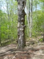
The road is not directly accessible from the main parking lot. Cross the dam and take either Lake Road through Ledbetter Gap onto Front Hollow Road or Bays Ridge Trail. Not marked at any trailhead or junction. You are able to hike up this road from the end of Bays Mountain Trail Road.
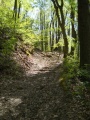
Eroded old rocky road. During the climb up from Front Hollow Road, there is a split in the middle which rejoins. The trail connects to Front Hollow Road and Bays Ridge Trail. Trail is better condition from it's trail head on Bays Mountain Trail Road and not really steep.
Severely washed out road on steep slopes, and natural gravel on top. Water will be flowing down thru the rut.
Not shown on the park map, but Jones Road may continue down Bays Ridge towards Reservoir Road.


