Jones Road: Difference between revisions
(Update IB to new format) |
(add map markers) |
||
| (12 intermediate revisions by 3 users not shown) | |||
| Line 1: | Line 1: | ||
{{Trail | |||
{{ | |Banner Image=File:BMP Jones Road.JPG | ||
|Park=Bays Mountain Park | |||
|Land Owner=City of Kingsport | |||
|Trail Marking=Signs | |||
|Trail Use=Hiking, Biking, Geocaching | |||
|Trail Features=Mountains | |||
|Difficulty Rating=Medium | |||
|Hike Time=2 hrs | |||
|Trail Distance=0.926 mi | |||
|Round Trip Distance=3.4 mi | |||
|Trail Type=Segment | |||
|High Point=2,101 ft | |||
|Low Point=1,767 ft | |||
|Elevation Gain=203 ft | |||
|Elevation Loss=335 ft | |||
|Elevation Change Direction=South-to-North | |||
|Parking location=36.50882, -82.60955 | |||
|Trailhead location=36.49603, -82.63159 | |||
}} | }} | ||
{{Trail Map|Other Trails=Front Hollow Road,Bays Ridge Road,Bays Ridge Trail}} | |||
__TOC__ | |||
== Trail Overview == | |||
'''*NOTE* - THE JUNCTION WHERE JONES ROAD SPLITS AWAY FROM BAYS RIDGE TRAIL AND LEAVES THE PARK IS NOT MARKED. THIS JUNCTION IS NOTORIOUS FOR HIKERS TO ACCIDENTALLY LEAVE THE PARK AND NOT REALIZE IT UNTIL THEY ARRIVE AT RESERVOIR ROAD''' | |||
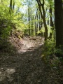
Located in [[Bays Mountain Park]]. Steep! eroded road between [[Front Hollow Road|Front Hollow Road]] at the "Big Oak" and [[Bays Ridge Trail]]. | |||
Located in [[Bays Mountain Park]]. Steep! eroded road between [[ | Parallels Bays Ridge Trail briefly before dropping off the ridgline out of the park on Bays Mountain Trail Road. It is possible to park your car at the end of Bays Mountain Trail Road and hike .5 miles into the park as a shortcut to the Hawkins County portion of the park. | ||
Terrific views to the south on clear days when the leaves are down. | |||
Sadly this entrance is also used for illegal dumping and for illegal ATVs to enter the park. | |||
== How to get there == | == How to get there == | ||
<!-- Please enter detailed instruction on how to find the trail head. --> | <!-- Please enter detailed instruction on how to find the trail head. --> | ||
The road is not directly accessible from the main parking lot. Cross the dam and take either [[ | The road is not directly accessible from the main parking lot. Cross the dam and take either [[Lake Road (Bays Mountain Park)|Lake Road]] through Ledbetter Gap onto [[Front Hollow Road|Front Hollow Road]] or [[Bays Ridge Trail]]. Not marked at any trailhead or junction. You are able to hike up this road from the end of Bays Mountain Trail Road. | ||
== Route Description== | == Route Description== | ||
[[File:Jones road profile.png|thumb|right]] | |||
Eroded old rocky road. During the climb up from Front Hollow Road, there is a split in the middle which rejoins. The trail connects to [[Trail connects to::Front Hollow Road]] and [[Trail connects to::Bays Ridge Trail]]. Trail is better condition from it's trail head on Bays Mountain Trail Road and not really steep. | |||
{| class="wikitable" border="1" | {| class="wikitable" border="1" | ||
| Line 36: | Line 46: | ||
!Jones Road | !Jones Road | ||
!Miles | !Miles | ||
|- | |- | ||
|0.0 | |0.0 | ||
|Trailhead at [[ | |Trailhead at [[Front Hollow Road|Front Hollow Road]] by the "Big Oak". No trail sign, but steepest path up from here. | ||
|1.0 | |||
|- | |||
|0.3 | |0.3 | ||
| | |Junction at [[Bays Ridge Trail]] | ||
|0.7 | |||
|- | |||
|0.5 | |||
|Split off from [[Bays Ridge Trail]] | |||
|0.5 | |||
|- | |- | ||
|0 | |||
|Trailhead at | |1.0 | ||
|Trailhead at Bays Mountain Trail Road | |||
|0.0 | |0.0 | ||
|} | |} | ||
| Line 56: | Line 76: | ||
<!-- Enter any additional information that doesn't fit an any other fields. Any seasonal features, factoids, etc...? --> | <!-- Enter any additional information that doesn't fit an any other fields. Any seasonal features, factoids, etc...? --> | ||
Not shown on the park map, but Jones Road may continue down Bays Ridge towards Reservoir Road. | Not shown on the park map, but Jones Road may continue down Bays Ridge towards Reservoir Road. | ||
== Photos == | == Photos == | ||
{{Park trail gallery|Trail={{PAGENAME}}}} | |||
{{Map Marker|Icon Type=Trail sign|Marker Title=Junction with [[Front Hollow Road|Front Hollow Road]] by "Big Oak"|Marker Description=[[Image:BMP Big Oak.JPG|150px]]|Marker Location=36.49603,-82.63158}} | |||
{{Map Marker|Icon Type=Trail sign|Marker Title=Junction with [[Bays Ridge Trail|Bays Ridge Trail]]|Marker Description=[[Image:Jones_Road_Junction_02.jpg|150px]]|Marker Location=36.49210,-82.63372}} | |||
Image:BMP Big Oak.JPG| | {{Map Marker|Icon Type=Trail sign|Marker Title=Arrives at ridgeline with [[Bays Ridge Trail|Bays Ridge Trail]]|Marker Description=[[Image:Jones_Road_Junction_01.jpg|150px]]|Marker Location=36.4927638891,-82.6321186832}} | ||
{{Map Marker|Icon Type=Parking|Marker Title=Parking at Bays Mountain Trail Road|Marker Description=[[Image:Jones_Road_Trailhead.jpg|150px]]|Marker Location=36.4939237401,-82.6241475614}} | |||
{{Map Marker|Icon Type=Photo spot|Marker Title=View towards Black Mountains in NC|Marker Description=[[Image:Jones_Road_View_Towards_Black_Mountains.jpg|150px]]|Marker Location=36.4926119583,-82.6326353052}} | |||
[[ | |||
Latest revision as of 17:19, 15 December 2019
| Jones Road (log in to submit report) | |
|---|---|

| |
| Park | Bays Mountain Park |
| Land Owner | City of Kingsport |
| Located | Kingsport, TennesseeLocation inherited from associated park |
| Trail Marking | Signs |
| Trail UseThings allowed to do on or near the trail |
|
| FeaturesThings to see on or near the trail |
|
| Difficulty Rating | Medium |
| Hiking TimeTime from car and back. Includes any time hiking to access this trail. | 2 hrs0.125 Days <br />120 Min <br /> round trip |
| Distance: | 0.926 mi1.49 km <br /> trailStrict non-repeating trail length / 3.4 mi5.472 km <br /> round tripTypical or shortest length from the car, hike the trail, and return to car |
| Trail Type | Segment |
| Low / High Point | 1,767 ft589 Yards <br />538.582 Meters <br /> / 2,101 ft700.333 Yards <br />640.385 Meters <br /> |
| Elev. Gain/LossSee link for details of calculation. Gain/Loss is direction dependent. | 203 ft61.874 Meters <br /> / (335 ft102.108 Meters <br />) – South-to-North |
| Trip ReportsFrom user "hiked it" submissions<br />Recent is within last 90 days | No hikes logged yet |
| NearbyWithin 5 mi<br />Click link to view list | 32 trails / 37.6 mi of trail |
| Parking | 36° 30' 31.75" N, 82° 36' 34.38" W Map |
| Trailhead | 36° 29' 45.71" N, 82° 37' 53.72" W Map |
|
| |
| Show In Google Maps | |
Download KML / Upload new version / KML File Page / Create Profile Chart / gpsvisualizer Map
Trail Overview[edit]
*NOTE* - THE JUNCTION WHERE JONES ROAD SPLITS AWAY FROM BAYS RIDGE TRAIL AND LEAVES THE PARK IS NOT MARKED. THIS JUNCTION IS NOTORIOUS FOR HIKERS TO ACCIDENTALLY LEAVE THE PARK AND NOT REALIZE IT UNTIL THEY ARRIVE AT RESERVOIR ROAD
Located in Bays Mountain Park. Steep! eroded road between Front Hollow Road at the "Big Oak" and Bays Ridge Trail.
Parallels Bays Ridge Trail briefly before dropping off the ridgline out of the park on Bays Mountain Trail Road. It is possible to park your car at the end of Bays Mountain Trail Road and hike .5 miles into the park as a shortcut to the Hawkins County portion of the park.
Terrific views to the south on clear days when the leaves are down.
Sadly this entrance is also used for illegal dumping and for illegal ATVs to enter the park.
How to get there[edit]
The road is not directly accessible from the main parking lot. Cross the dam and take either Lake Road through Ledbetter Gap onto Front Hollow Road or Bays Ridge Trail. Not marked at any trailhead or junction. You are able to hike up this road from the end of Bays Mountain Trail Road.
Route Description[edit]

Eroded old rocky road. During the climb up from Front Hollow Road, there is a split in the middle which rejoins. The trail connects to Front Hollow Road and Bays Ridge Trail. Trail is better condition from it's trail head on Bays Mountain Trail Road and not really steep.
| Miles | Jones Road | Miles |
|---|---|---|
| 0.0 | Trailhead at Front Hollow Road by the "Big Oak". No trail sign, but steepest path up from here. | 1.0 |
| 0.3 | Junction at Bays Ridge Trail | 0.7 |
| 0.5 | Split off from Bays Ridge Trail | 0.5 |
| 1.0 | Trailhead at Bays Mountain Trail Road | 0.0 |
Typical Conditions[edit]
Severely washed out road on steep slopes, and natural gravel on top. Water will be flowing down thru the rut.
Misc. Information[edit]
Not shown on the park map, but Jones Road may continue down Bays Ridge towards Reservoir Road.
Photos[edit]
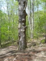
Big Oak at bottom of Jones Road

Trail Profile
