John Tomko Trail: Difference between revisions
(→Maps: parking pin) |
m (Text replacement - "http://tehcc.org/clubwiki/" to "https://tehcc.org/clubwiki/") |
||
| (14 intermediate revisions by 4 users not shown) | |||
| Line 1: | Line 1: | ||
<!-- The following few lines create the "Infobox" table template. Please scroll down to edit the main content of the article. | <!-- The following few lines create the "Infobox" table template. Please scroll down to edit the main content of the article. | ||
<!-- | -->{{Infobox Trail | ||
| Image Name = PRP_John_Tomko_trail_sign.JPG | |||
| Park = Persimmon Ridge Park | |||
| City = Jonesborough | |||
| State = Tennessee | |||
| Marking = Unknown | |||
| Trail Use = {{Hike}}{{Dogs}} | |||
| Difficulty Rating = Easy | |||
| Hike Time = 0.5 | |||
| Distance = 0.65 | |||
| Elevation Gain = 198 | |||
| High Point = 1977 | |||
| Latitude = 36.28825 | |||
| Longitude = -82.49837 | |||
| Medical = Johnson City, TN | |||
}}<!-- | |||
End Infobox template table | |||
-->{{Trail page needs | |||
| Hide needs = | |||
| KML = | |||
| Updated KML = | |||
| Detail route description = Yes | |||
| Photos = | |||
| Winter photos = | |||
| Remove prefix = Yes | |||
| Update infobox = Yes | |||
| Infobox data update = Yes | |||
| Trail pins = | |||
| Other = | |||
| Comment = | |||
| Date reviewed = 10/31/2015 | |||
}}<!-- | |||
Start of Main Page --> | |||
== Trail Overview == | == Trail Overview == | ||
<!-- Enter a overview of the trail. What attracts you to this trail, points of interest, types of flowers, lakes, and peaks that you see along the way. --> | <!-- Enter a overview of the trail. What attracts you to this trail, points of interest, types of flowers, lakes, and peaks that you see along the way. --> | ||
| Line 52: | Line 66: | ||
|0.65 | |0.65 | ||
|Western trailhead up at water tank | |Western trailhead up at water tank | ||
|0. | |0.00 | ||
|1971 | |1971 | ||
|} | |} | ||
| Line 58: | Line 72: | ||
== Typical Conditions == | == Typical Conditions == | ||
<!-- Typical conditions throughout the year of what to expect on the trail. Rocky, muddy, sandy, flowers, lots of downed trees? --> | <!-- Typical conditions throughout the year of what to expect on the trail. Rocky, muddy, sandy, flowers, lots of downed trees? --> | ||
Hard dirt trail | Hard dirt trail. Missing signage at actual trail - would be great at gravel road. Someone has removed several blowdowns, but trail had to be slightly rerouted a four trunk pile. Also a weed trimmer might have been used to clear ground weeds. Lots of trimming needed today at shoulder level to have a readily passable path. | ||
== Regulations == | == Regulations == | ||
No Bicycles | |||
-Hiking and Bushcraft welcome | |||
== Misc. Information == | == Misc. Information == | ||
<!-- Enter any additional information that doesn't fit an any other fields. Any seasonal features, factoids, etc...? --> | <!-- Enter any additional information that doesn't fit an any other fields. Any seasonal features, factoids, etc...? --> | ||
The trail is named after | The trail is named after John Tomko, who led its construction for his Eagle Scout project. Might have been part of Boy Scout Troop 39 (to be confirmed). | ||
== Maps == | == Maps == | ||
<!-- You can place pictures, PDF's, links, or even create a Google map with your waypoints and place it here. --> | <!-- You can place pictures, PDF's, links, or even create a Google map with your waypoints and place it here. --> | ||
John Tomko Trail is shown as yellow line below. Water Hopkins Trail is green. Luke Carter Trail is red. Gravel access roads in blue. | |||
< | <display_map center="36.2875,-82.505" type="terrain" zoom="15" width="700" height="550" gkml="https://tehcc.org/clubwiki/kml/PRP_Luke_Carter_Trail.kml, | ||
https://tehcc.org/clubwiki/kml/PRP_Walter_Hopkins_Trail.kml, | |||
https://tehcc.org/clubwiki/kml/PRP_John_Tomko_Trail.kml, | |||
https://tehcc.org/clubwiki/kml/PRP_Gravel_Road.kml"> | |||
36.289343,-82.503302~Eastern trailhead~ ~MarkerG.png | |||
Eastern trailhead | 36.282225,-82.508721~Western trailhead~ ~MarkerG.png | ||
36.290010,-82.501231~Parking at ballfields~ ~MarkerA.png | |||
Western trailhead | </display_map> | ||
Parking at ballfields | |||
</ | |||
== Photos == | == Photos == | ||
| Line 88: | Line 100: | ||
<!-- Place any pictures from this trail below. Ideally we would have a picture of the trailhead to help people know when they found it --> | <!-- Place any pictures from this trail below. Ideally we would have a picture of the trailhead to help people know when they found it --> | ||
<!-- Add a picture by typing Image:imagename.extension --> | <!-- Add a picture by typing Image:imagename.extension --> | ||
Image: | Image:PRP_John_Tomko_water_tank.jpg|City water tank at top of trail | ||
Image:PRP_John_Tomko_blowdown_pile.jpg|Trail diverted around blowdowns | |||
<!-- Do not remove the end gallery code.--> | <!-- Do not remove the end gallery code.--> | ||
Revision as of 12:06, 7 January 2023
| |||||||||||||||||||||||||||||||||||||||

Trail Overview
Located in Persimmon Ridge Park. A ridgeline hike through second generation hardwoods with gap view at powerline down at Wetlands water park.
How to get there
Driving direction on main park page. Parking for the main trailhead is located at the ballfields. Follow the gravel roadway along Field #1 until it takes a sharp left turn. This is the access road to the water tower. John's trail is on right at a post which used to have a sign.
Route Description
| Miles | John Tomko Trail | Miles | Elevation |
|---|---|---|---|
| 0.0 | Eastern trailhead | 0.65 | 1781 |
| 0.45 | Intersect gravel road which heads to water tank | 0.20 | 1910 |
| 0.65 | Western trailhead up at water tank | 0.00 | 1971 |
Typical Conditions
Hard dirt trail. Missing signage at actual trail - would be great at gravel road. Someone has removed several blowdowns, but trail had to be slightly rerouted a four trunk pile. Also a weed trimmer might have been used to clear ground weeds. Lots of trimming needed today at shoulder level to have a readily passable path.
Regulations
No Bicycles -Hiking and Bushcraft welcome
Misc. Information
The trail is named after John Tomko, who led its construction for his Eagle Scout project. Might have been part of Boy Scout Troop 39 (to be confirmed).
Maps
John Tomko Trail is shown as yellow line below. Water Hopkins Trail is green. Luke Carter Trail is red. Gravel access roads in blue.
Photos
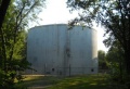
City water tank at top of trail
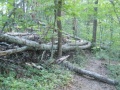
Trail diverted around blowdowns

