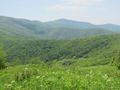
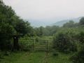
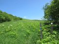
Working farm with hiking trails leading into nice forests. Important bird-watching area for rare golden-winged warblers.
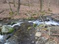
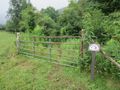
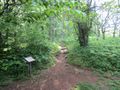
There are currently three trails in the nature area. All begin from the parking lot by following the Overmountain Trail to common junction. Shell Hollow proceeds up a dirt road past a former homestead to become a loop up on Big Ridge. Birchfield Trail follows the western side of Left Prong creek until it rejoins the Overmountain Trail, which proceeds on the eastern side of the creek but continues up Yellow Mountain to intersection with the Appalachian Trail at the gap.
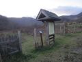
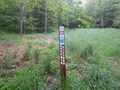
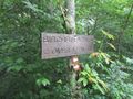
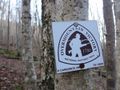
Signage for the OVNHT is adequate while those for the other two trails needs to be updated as not clear where are their lower access points. The information kiosks at several points also have badly crazed, thus should be considered for replacement.
No permit or fee. The nature area closes at dusk.
NOTE Hunting is permitted. Use precaution when hiking during hunting season
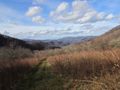
Hampton Creek Cove is a 693-acre natural area.
Loading map...
{"type":"TERRAIN","minzoom":false,"maxzoom":false,"types":["ROADMAP","SATELLITE","HYBRID","TERRAIN"],"mappingservice":"googlemaps3","width":"auto","height":"600px","centre":false,"title":"","label":"","icon":"","lines":[],"polygons":[],"circles":[],"rectangles":[],"copycoords":false,"static":false,"visitedicon":"","wmsoverlay":false,"zoom":false,"layers":[],"controls":["pan","zoom","type","scale","streetview","rotate"],"zoomstyle":"DEFAULT","typestyle":"DEFAULT","autoinfowindows":false,"resizable":false,"kmlrezoom":false,"poi":true,"cluster":false,"clustergridsize":60,"clustermaxzoom":20,"clusterzoomonclick":true,"clusteraveragecenter":true,"clusterminsize":2,"imageoverlays":[],"kml":[],"gkml":["http://tehcc.org/clubwiki/kml/HCCSNA_Birchfield_Trail.kml","http://tehcc.org/clubwiki/kml/HCCSNA_Overmountain_Shelter_Trail.kml","http://tehcc.org/clubwiki/kml/HCCSNA_Overmountain_Victory_Trail.kml","http://tehcc.org/clubwiki/kml/HCCSNA_Shell_Hollow_Trail.kml"],"searchmarkers":"","fullscreen":false,"scrollwheelzoom":false,"locations":[{"text":"\u003Cb\u003E\u003Cdiv class=\"mw-parser-output\"\u003E\u003Cp\u003EView into Hampton Cove\n\u003C/p\u003E\u003C/div\u003E\u003C/b\u003E\u003Cdiv class=\"mw-parser-output\"\u003E\u003Cp\u003E\u003Ca href=\"/wiki/File:HCCSNA_View_Into_Hampton_Cove.jpg\" class=\"image\"\u003E\u003Cimg alt=\"HCCSNA View Into Hampton Cove.jpg\" src=\"/clubwiki/images/thumb/HCCSNA_View_Into_Hampton_Cove.jpg/150px-HCCSNA_View_Into_Hampton_Cove.jpg\" decoding=\"async\" width=\"150\" height=\"113\" srcset=\"/clubwiki/images/thumb/HCCSNA_View_Into_Hampton_Cove.jpg/225px-HCCSNA_View_Into_Hampton_Cove.jpg 1.5x, /clubwiki/images/thumb/HCCSNA_View_Into_Hampton_Cove.jpg/300px-HCCSNA_View_Into_Hampton_Cove.jpg 2x\" data-file-width=\"1200\" data-file-height=\"900\" /\u003E\u003C/a\u003E\n\u003C/p\u003E\u003C/div\u003E","title":"View into Hampton Cove\n","link":"","lat":36.13413757869999898275636951439082622528076171875,"lon":-82.0405528417999931889426079578697681427001953125,"icon":"/clubwiki/images/MarkerB.png"},{"text":"\u003Cdiv class=\"mw-parser-output\"\u003E\u003Cp\u003EHampton Cove Parking\n\u003C/p\u003E\u003C/div\u003E","title":"Hampton Cove Parking\n","link":"","lat":36.15231279230000183133597602136433124542236328125,"lon":-82.0556224481999976205770508386194705963134765625,"icon":"/clubwiki/images/MarkerA.png"},{"text":"\u003Cdiv class=\"mw-parser-output\"\u003E\u003Cp\u003ERoaring Creek Parking\n\u003C/p\u003E\u003C/div\u003E","title":"Roaring Creek Parking\n","link":"","lat":36.1170074500000026773705030791461467742919921875,"lon":-82.0489487139000033266711398027837276458740234375,"icon":"/clubwiki/images/MarkerA.png"},{"text":"\u003Cb\u003E\u003Cdiv class=\"mw-parser-output\"\u003E\u003Cp\u003EOvermountain Barn\n\u003C/p\u003E\u003C/div\u003E\u003C/b\u003E\u003Cdiv class=\"mw-parser-output\"\u003E\u003Cp\u003E\u003Ca href=\"/wiki/File:HCCSNA_Overmountain_Barn_From_AT.jpg\" class=\"image\"\u003E\u003Cimg alt=\"HCCSNA Overmountain Barn From AT.jpg\" src=\"/clubwiki/images/thumb/HCCSNA_Overmountain_Barn_From_AT.jpg/150px-HCCSNA_Overmountain_Barn_From_AT.jpg\" decoding=\"async\" width=\"150\" height=\"113\" srcset=\"/clubwiki/images/thumb/HCCSNA_Overmountain_Barn_From_AT.jpg/225px-HCCSNA_Overmountain_Barn_From_AT.jpg 1.5x, /clubwiki/images/thumb/HCCSNA_Overmountain_Barn_From_AT.jpg/300px-HCCSNA_Overmountain_Barn_From_AT.jpg 2x\" data-file-width=\"1200\" data-file-height=\"900\" /\u003E\u003C/a\u003E\n\u003C/p\u003E\u003C/div\u003E","title":"Overmountain Barn\n","link":"","lat":36.123615000000000918589648790657520294189453125,"lon":-82.054214000000001760781742632389068603515625,"icon":"/clubwiki/images/MarkerF.png"},{"text":"\u003Cdiv class=\"mw-parser-output\"\u003E\u003Cp\u003EShell Cemetery\n\u003C/p\u003E\u003C/div\u003E","title":"Shell Cemetery\n","link":"","lat":36.14895009939999681591871194541454315185546875,"lon":-82.0430267086999975845174049027264118194580078125,"icon":"/clubwiki/images/MarkerN.png"},{"text":"\u003Cb\u003E\u003Cdiv class=\"mw-parser-output\"\u003E\u003Cp\u003ECreek Crossing\n\u003C/p\u003E\u003C/div\u003E\u003C/b\u003E\u003Cdiv class=\"mw-parser-output\"\u003E\u003Cp\u003E\u003Ca href=\"/wiki/File:HCCSNA_Birchfield_Creek_Crossing.jpg\" class=\"image\"\u003E\u003Cimg alt=\"HCCSNA Birchfield Creek Crossing.jpg\" src=\"/clubwiki/images/thumb/HCCSNA_Birchfield_Creek_Crossing.jpg/150px-HCCSNA_Birchfield_Creek_Crossing.jpg\" decoding=\"async\" width=\"150\" height=\"113\" srcset=\"/clubwiki/images/thumb/HCCSNA_Birchfield_Creek_Crossing.jpg/225px-HCCSNA_Birchfield_Creek_Crossing.jpg 1.5x, /clubwiki/images/thumb/HCCSNA_Birchfield_Creek_Crossing.jpg/300px-HCCSNA_Birchfield_Creek_Crossing.jpg 2x\" data-file-width=\"1200\" data-file-height=\"900\" /\u003E\u003C/a\u003E\n\u003C/p\u003E\u003C/div\u003E","title":"Creek Crossing\n","link":"","lat":36.14044095599999906198718235827982425689697265625,"lon":-82.0468414829000067811648477800190448760986328125,"icon":"/clubwiki/images/MarkerJ.png"},{"text":"\u003Cb\u003E\u003Cdiv class=\"mw-parser-output\"\u003E\u003Cp\u003EFarm Gate\n\u003C/p\u003E\u003C/div\u003E\u003C/b\u003E\u003Cdiv class=\"mw-parser-output\"\u003E\u003Cp\u003E\u003Ca href=\"/wiki/File:HCCSNA_Farm_Gate_01.jpg\" class=\"image\"\u003E\u003Cimg alt=\"HCCSNA Farm Gate 01.jpg\" src=\"/clubwiki/images/thumb/HCCSNA_Farm_Gate_01.jpg/150px-HCCSNA_Farm_Gate_01.jpg\" decoding=\"async\" width=\"150\" height=\"113\" srcset=\"/clubwiki/images/thumb/HCCSNA_Farm_Gate_01.jpg/225px-HCCSNA_Farm_Gate_01.jpg 1.5x, /clubwiki/images/thumb/HCCSNA_Farm_Gate_01.jpg/300px-HCCSNA_Farm_Gate_01.jpg 2x\" data-file-width=\"1200\" data-file-height=\"900\" /\u003E\u003C/a\u003E\n\u003C/p\u003E\u003C/div\u003E","title":"Farm Gate\n","link":"","lat":36.14105681000000203084709937684237957000732421875,"lon":-82.04615334999999731735442765057086944580078125,"icon":"/clubwiki/images/MarkerG.png"},{"text":"\u003Cb\u003E\u003Cdiv class=\"mw-parser-output\"\u003E\u003Cp\u003EFarm Gate\n\u003C/p\u003E\u003C/div\u003E\u003C/b\u003E\u003Cdiv class=\"mw-parser-output\"\u003E\u003Cp\u003E\u003Ca href=\"/wiki/File:HCCSNA_Farm_Gate_02.jpg\" class=\"image\"\u003E\u003Cimg alt=\"HCCSNA Farm Gate 02.jpg\" src=\"/clubwiki/images/thumb/HCCSNA_Farm_Gate_02.jpg/150px-HCCSNA_Farm_Gate_02.jpg\" decoding=\"async\" width=\"150\" height=\"113\" srcset=\"/clubwiki/images/thumb/HCCSNA_Farm_Gate_02.jpg/225px-HCCSNA_Farm_Gate_02.jpg 1.5x, /clubwiki/images/thumb/HCCSNA_Farm_Gate_02.jpg/300px-HCCSNA_Farm_Gate_02.jpg 2x\" data-file-width=\"1200\" data-file-height=\"900\" /\u003E\u003C/a\u003E\n\u003C/p\u003E\u003C/div\u003E","title":"Farm Gate\n","link":"","lat":36.1379704200000020364313968457281589508056640625,"lon":-82.0443995199999989154093782417476177215576171875,"icon":"/clubwiki/images/MarkerG.png"},{"text":"\u003Cb\u003E\u003Cdiv class=\"mw-parser-output\"\u003E\u003Cp\u003ETrailhead Hampton Creek\n\u003C/p\u003E\u003C/div\u003E\u003C/b\u003E\u003Cdiv class=\"mw-parser-output\"\u003E\u003Cp\u003E\u003Ca href=\"/wiki/File:HCCSNA_Trailhead_Hampton_Creek.jpg\" class=\"image\"\u003E\u003Cimg alt=\"HCCSNA Trailhead Hampton Creek.jpg\" src=\"/clubwiki/images/thumb/HCCSNA_Trailhead_Hampton_Creek.jpg/150px-HCCSNA_Trailhead_Hampton_Creek.jpg\" decoding=\"async\" width=\"150\" height=\"113\" srcset=\"/clubwiki/images/thumb/HCCSNA_Trailhead_Hampton_Creek.jpg/225px-HCCSNA_Trailhead_Hampton_Creek.jpg 1.5x, /clubwiki/images/thumb/HCCSNA_Trailhead_Hampton_Creek.jpg/300px-HCCSNA_Trailhead_Hampton_Creek.jpg 2x\" data-file-width=\"1200\" data-file-height=\"900\" /\u003E\u003C/a\u003E\n\u003C/p\u003E\u003C/div\u003E","title":"Trailhead Hampton Creek\n","link":"","lat":36.15230572819999821376768522895872592926025390625,"lon":-82.0554279669999999669016688130795955657958984375,"icon":"/clubwiki/images/MarkerT.png"},{"text":"\u003Cb\u003E\u003Cdiv class=\"mw-parser-output\"\u003E\u003Cp\u003ETrailhead Roaring Creek\n\u003C/p\u003E\u003C/div\u003E\u003C/b\u003E\u003Cdiv class=\"mw-parser-output\"\u003E\u003Cp\u003E\u003Ca href=\"/wiki/File:HCCSNA_Trailhead_Roaring_Creek.jpg\" class=\"image\"\u003E\u003Cimg alt=\"HCCSNA Trailhead Roaring Creek.jpg\" src=\"/clubwiki/images/thumb/HCCSNA_Trailhead_Roaring_Creek.jpg/150px-HCCSNA_Trailhead_Roaring_Creek.jpg\" decoding=\"async\" width=\"150\" height=\"113\" srcset=\"/clubwiki/images/thumb/HCCSNA_Trailhead_Roaring_Creek.jpg/225px-HCCSNA_Trailhead_Roaring_Creek.jpg 1.5x, /clubwiki/images/thumb/HCCSNA_Trailhead_Roaring_Creek.jpg/300px-HCCSNA_Trailhead_Roaring_Creek.jpg 2x\" data-file-width=\"1200\" data-file-height=\"900\" /\u003E\u003C/a\u003E\n\u003C/p\u003E\u003C/div\u003E","title":"Trailhead Roaring Creek\n","link":"","lat":36.11689075230000156579990289174020290374755859375,"lon":-82.0486987935999962928690365515649318695068359375,"icon":"/clubwiki/images/MarkerT.png"},{"text":"\u003Cb\u003E\u003Cdiv class=\"mw-parser-output\"\u003E\u003Cp\u003ETrail Junction Shelter Trail\n\u003C/p\u003E\u003C/div\u003E\u003C/b\u003E\u003Cdiv class=\"mw-parser-output\"\u003E\u003Cp\u003E\u003Ca href=\"/wiki/File:HCCSNA_Junctions_Shelter_Trail.jpg\" class=\"image\"\u003E\u003Cimg alt=\"HCCSNA Junctions Shelter Trail.jpg\" src=\"/clubwiki/images/thumb/HCCSNA_Junctions_Shelter_Trail.jpg/150px-HCCSNA_Junctions_Shelter_Trail.jpg\" decoding=\"async\" width=\"150\" height=\"113\" srcset=\"/clubwiki/images/thumb/HCCSNA_Junctions_Shelter_Trail.jpg/225px-HCCSNA_Junctions_Shelter_Trail.jpg 1.5x, /clubwiki/images/thumb/HCCSNA_Junctions_Shelter_Trail.jpg/300px-HCCSNA_Junctions_Shelter_Trail.jpg 2x\" data-file-width=\"1200\" data-file-height=\"900\" /\u003E\u003C/a\u003E\n\u003C/p\u003E\u003C/div\u003E","title":"Trail Junction Shelter Trail\n","link":"","lat":36.1255151268999981084562023170292377471923828125,"lon":-82.05124094789999844579142518341541290283203125,"icon":"/clubwiki/images/MarkerT.png"},{"text":"\u003Cb\u003E\u003Cdiv class=\"mw-parser-output\"\u003E\u003Cp\u003EYellow Mountain Gap Junction\n\u003C/p\u003E\u003C/div\u003E\u003C/b\u003E\u003Cdiv class=\"mw-parser-output\"\u003E\u003Cp\u003E\u003Ca href=\"/wiki/File:HCCSNA_Junctions_Yellow_Mountain_Gap.jpg\" class=\"image\"\u003E\u003Cimg alt=\"HCCSNA Junctions Yellow Mountain Gap.jpg\" src=\"/clubwiki/images/thumb/HCCSNA_Junctions_Yellow_Mountain_Gap.jpg/150px-HCCSNA_Junctions_Yellow_Mountain_Gap.jpg\" decoding=\"async\" width=\"150\" height=\"113\" srcset=\"/clubwiki/images/thumb/HCCSNA_Junctions_Yellow_Mountain_Gap.jpg/225px-HCCSNA_Junctions_Yellow_Mountain_Gap.jpg 1.5x, /clubwiki/images/thumb/HCCSNA_Junctions_Yellow_Mountain_Gap.jpg/300px-HCCSNA_Junctions_Yellow_Mountain_Gap.jpg 2x\" data-file-width=\"1200\" data-file-height=\"900\" /\u003E\u003C/a\u003E\n\u003C/p\u003E\u003C/div\u003E","title":"Yellow Mountain Gap Junction\n","link":"","lat":36.12575879229999742392465122975409030914306640625,"lon":-82.05145379169999841906246729195117950439453125,"icon":"/clubwiki/images/MarkerT.png"},{"text":"\u003Cb\u003E\u003Cdiv class=\"mw-parser-output\"\u003E\u003Cp\u003EJunction Birchfield Trail North\n\u003C/p\u003E\u003C/div\u003E\u003C/b\u003E\u003Cdiv class=\"mw-parser-output\"\u003E\u003Cp\u003E\u003Ca href=\"/wiki/File:HCCSNA_Junctions_North.jpg\" class=\"image\"\u003E\u003Cimg alt=\"HCCSNA Junctions North.jpg\" src=\"/clubwiki/images/thumb/HCCSNA_Junctions_North.jpg/150px-HCCSNA_Junctions_North.jpg\" decoding=\"async\" width=\"150\" height=\"113\" srcset=\"/clubwiki/images/thumb/HCCSNA_Junctions_North.jpg/225px-HCCSNA_Junctions_North.jpg 1.5x, /clubwiki/images/thumb/HCCSNA_Junctions_North.jpg/300px-HCCSNA_Junctions_North.jpg 2x\" data-file-width=\"1200\" data-file-height=\"900\" /\u003E\u003C/a\u003E\n\u003C/p\u003E\u003C/div\u003E","title":"Junction Birchfield Trail North\n","link":"","lat":36.1353754626999972288103890605270862579345703125,"lon":-82.04251037410000435556867159903049468994140625,"icon":"/clubwiki/images/MarkerT.png"},{"text":"\u003Cb\u003E\u003Cdiv class=\"mw-parser-output\"\u003E\u003Cp\u003EJunction Birchfield Trail South\n\u003C/p\u003E\u003C/div\u003E\u003C/b\u003E\u003Cdiv class=\"mw-parser-output\"\u003E\u003Cp\u003E\u003Ca href=\"/wiki/File:HCCSNA_Junctions_South.jpg\" class=\"image\"\u003E\u003Cimg alt=\"HCCSNA Junctions South.jpg\" src=\"/clubwiki/images/thumb/HCCSNA_Junctions_South.jpg/150px-HCCSNA_Junctions_South.jpg\" decoding=\"async\" width=\"150\" height=\"113\" srcset=\"/clubwiki/images/thumb/HCCSNA_Junctions_South.jpg/225px-HCCSNA_Junctions_South.jpg 1.5x, /clubwiki/images/thumb/HCCSNA_Junctions_South.jpg/300px-HCCSNA_Junctions_South.jpg 2x\" data-file-width=\"1200\" data-file-height=\"900\" /\u003E\u003C/a\u003E\n\u003C/p\u003E\u003C/div\u003E","title":"Junction Birchfield Trail South\n","link":"","lat":36.14698840129999979353669914416968822479248046875,"lon":-82.0495906876000020702122128568589687347412109375,"icon":"/clubwiki/images/MarkerT.png"}]}