Grassy Ridge: Difference between revisions
(→Photos) |
(Added gmap, link to SB6000, and updated infobox map to standard) |
||
| Line 2: | Line 2: | ||
{{Infobox Trail | {{Infobox Trail | ||
| Image Name = GrassyRidge_View.jpg | | Image Name = GrassyRidge_View.jpg | ||
| City = Roan Mountain | | City = Roan Mountain | ||
| State = Tennessee | | State = Tennessee | ||
| Trail Use = {{Hike}}{{Camping}} | | Trail Use = {{Hike}}{{Camping}} | ||
| Difficulty Rating = Easy | | Difficulty Rating = Easy | ||
| Hike Time = 4 | | Hike Time = 4 | ||
| Line 17: | Line 15: | ||
<!-- DON'T EDIT THE GOOGLEMAP TAG --> | <!-- DON'T EDIT THE GOOGLEMAP TAG --> | ||
| googlemap = | | googlemap = | ||
<googlemap lat="36.10625" lon="-82.110183" zoom=" | <googlemap lat="36.10625" lon="-82.110183" zoom="9" width="270" type="map" height="180" selector="no" controls="small"> | ||
36.10625,-82.110183 | 36.10625,-82.110183,Grassy Ridge | ||
</googlemap> | </googlemap> | ||
}} | }} | ||
| Line 60: | Line 57: | ||
<!-- Enter any additional information that doesn't fit an any other fields. Does this trail require any permits for overnight? parking? --> | <!-- Enter any additional information that doesn't fit an any other fields. Does this trail require any permits for overnight? parking? --> | ||
Baa-tany Goat Project [http://friendsofroanmtn.org/goat%20project/goat%20project.html FoRM link] | Baa-tany Goat Project [http://friendsofroanmtn.org/goat%20project/goat%20project.html FoRM link] | ||
Grassy Ridge is one of the [http://www.carolinamountainclub.org/index.cfm/do/pages.view/id/190/page/SB6K-RoanMts South Beyond 6000] peaks. | |||
== Maps == | == Maps == | ||
<!-- You can place pictures, PDF's, links, or even create a Google map with your waypoints and place it here. --> | <!-- You can place pictures, PDF's, links, or even create a Google map with your waypoints and place it here. --> | ||
<googlemap version="0.9" lat="36.10625" lon="-82.110183" type="terrain" zoom="14" width="700" scale="yes" icons="http://tehcc.org/clubwiki/kml/marker{label}.png"> | |||
http://tehcc.org/clubwiki/kml/placeholder.kml | |||
(A) 36.10625,-82.110183 | |||
Parking at Carver's Gap | |||
(G) 36.1001,-82.080883 | |||
Grassy Ridge | |||
</googlemap> | |||
== Photos == | == Photos == | ||
Revision as of 21:55, 5 January 2012
| |||||||||||||||||||||||||||||||||||||

Trail Overview
Spur trail off AT above Carver's Gap. Hike across balds by Catawba rhododendron (late June to September), pick huckleberries (August to mid-September), see the goats (July thru September), and reach the natural 360˚ view on the summit.
How to get there
From Kingsport, TN
- Take I-26 south to Exit 24 for US-321/TN-67 toward Elizabethton.
- Continue through Elizabethton and right at traffic light to stay on US-321 South.
- At Hampton, stay on US19E as it veers right.
- At Roan Mountain, turn right (south) onto TN143.
- Travel 13 miles to the TN/NC border and park at Carver's Gap.
(Alternatively at Steps 2-3, once just inside Elizabethton city limits, turn right on TN-362, then right again and follow Gap Creek Rd for 8 miles to US19E, thus bypassing around Elizabethton and Hampton.)
Route Description
From Carver's Gap, take AT northbound up and over the balds. (Stay on the trail path!) At roughly two miles along the AT, a junction sign will show the spur trail up to Grassy Ridge, which climbs up an established rut (which can become a creek in the rain). Reach the rock outcropping at the summit. Read the dedication plaque to Cornelious Rex Peake. Have lunch. And then return by reverse route.
Typical Conditions
From path from the trailhead over a couple of the balds has been specifically routed and hardened using gravel on geotextile. Stay on this path to avoid damage to the fragile landscape. Accessible year-around, thus can be snow covered trail in winter to summer rainshowers. High enough elevation to sometimes be "up in the clouds" as mist passed up and over the gap.
Fees, Permits, etc.
No permits or fees.
After the Hike
Ice cream at Bob's Dairyland back down in Roan Mountain, TN - yum.
Misc. Information
Baa-tany Goat Project FoRM link
Grassy Ridge is one of the South Beyond 6000 peaks.
Maps
<googlemap version="0.9" lat="36.10625" lon="-82.110183" type="terrain" zoom="14" width="700" scale="yes" icons="http://tehcc.org/clubwiki/kml/marker{label}.png"> http://tehcc.org/clubwiki/kml/placeholder.kml
(A) 36.10625,-82.110183 Parking at Carver's Gap (G) 36.1001,-82.080883 Grassy Ridge </googlemap>
Photos
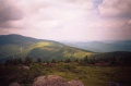
View back the way you came
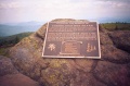
Plaque dedicated to Cornelious Rex Peake
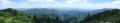
Panorama of the southern end of Grassy Ridge

