GSMNP Ramsey Cascades: Difference between revisions
Jump to navigation
Jump to search
(→Maps: Coords for falls) |
m (Text replacement - "http://tehcc.org/clubwiki/" to "https://tehcc.org/clubwiki/") |
||
| (23 intermediate revisions by 2 users not shown) | |||
| Line 1: | Line 1: | ||
<!-- The following few lines create the "Infobox" table template. Please scroll down to edit the main content of the article. | <!-- The following few lines create the "Infobox" table template. Please scroll down to edit the main content of the article. | ||
<!-- | -->{{Infobox Trail | ||
| Image Name = GSMNP_Ramsey_Cascades.JPG | |||
| Park = Great Smoky Mountains National Park | |||
| City = Gatlinburg | |||
| State = Tennessee | |||
| Marking = None | |||
| Trail Use = {{Hike}} {{Waterfall}} | |||
| Difficulty Rating = Hard | |||
| Hike Time = 2 Hours | |||
| Round Trip Distance = 8.04 Mi | |||
| Trail Distance = 4.02 Mi | |||
| Trail Type = In-and-Out | |||
| Elevation Gain = 2,644 Ft | |||
| Elevation Loss = -435 Ft | |||
| High Point = 4,269 Ft | |||
| Parking coords = 35.70277,-83.35727 | |||
| Trailhead coords = 35.70277,-83.35727 | |||
| Medical = Sevierville | |||
}}<!-- | |||
End Infobox template table | |||
-->{{Trail page needs | |||
| Hide needs = | |||
| KML = | |||
| Updated KML = | |||
| Detail route description = | |||
| Photos = | |||
| Winter photos = Yes | |||
| Remove prefix = Yes | |||
| Update infobox = | |||
| Infobox data update = | |||
| Trail pins = | |||
| Other = | |||
| Comment = winter waterfall pictures? | |||
| Date reviewed = 10/25/2015 | |||
}}<!-- | |||
Start of Main Page --> | |||
== Trail Overview == | == Trail Overview == | ||
<!-- Enter a overview of the trail. What attracts you to this trail, points of interest, types of flowers, lakes, and peaks that you see along the way. --> | <!-- Enter a overview of the trail. What attracts you to this trail, points of interest, types of flowers, lakes, and peaks that you see along the way. --> | ||
Located in the [[Great Smoky Mountains National Park]], a challenging hike up through classic forest to a ~100' cascading waterfall. Some massive old growth trees can also be seen. | |||
== How to get there == | == How to get there == | ||
| Line 29: | Line 50: | ||
#Turn right into Great Smoky Mountains National Park at Greenbrier entrance. | #Turn right into Great Smoky Mountains National Park at Greenbrier entrance. | ||
#Travel just over four miles on road which changes from paved to gravel. | #Travel just over four miles on road which changes from paved to gravel. | ||
#Turn left to cross road | #Turn left to cross road bridge. NOTE: There is now a small directional sign here. Continuing straight arrives at [[GSMNP Porter Creek]] trailhead. | ||
#Travel less than mile to parking area | #Travel less than mile to parking area | ||
Trailhead is past large boulders and locked gate. | Trailhead is past large boulders and locked gate. | ||
| Line 35: | Line 56: | ||
== Route Description== | == Route Description== | ||
<!-- Detailed description of the route. Is there any side trails that are worth traveling? --> | <!-- Detailed description of the route. Is there any side trails that are worth traveling? --> | ||
The | The trail follows a gravel logging road at first, then turns uphill to follow the stream to the waterfall. | ||
{| class="wikitable" border="1" | {| class="wikitable" border="1" | ||
|- | |- | ||
! | !Distance (mi) | ||
!Elevation (ft) | |||
!Description | !Description | ||
|- | |- | ||
|0.0 | |0.0 | ||
|2060 | |||
|Trailhead | |Trailhead | ||
|- | |- | ||
|1.5 | |1.5 | ||
|2660 | |||
|End of gravel section. Begin dirt tread. | |End of gravel section. Begin dirt tread. | ||
|- | |- | ||
|2.5 | |2.5 | ||
|3235 | |||
|Three towering old growth tulip poplars. | |Three towering old growth tulip poplars. | ||
|- | |- | ||
|4.0 | |4.0 | ||
|4310 | |||
|Ramsey Cascades | |Ramsey Cascades | ||
|} | |} | ||
| Line 61: | Line 87: | ||
== Fees, Permits, etc. == | == Fees, Permits, etc. == | ||
<!-- Please list any Fees, Permits, Regulations, etc. that may be required on this trail.--> | <!-- Please list any Fees, Permits, Regulations, etc. that may be required on this trail.--> | ||
No fee | No fee. Per NPS policy, no mountain bikes or dogs (if their owners cannot read the clearly posted signs). | ||
== After the Hike == | == After the Hike == | ||
| Line 70: | Line 94: | ||
== Misc. Information == | == Misc. Information == | ||
<!-- Enter any additional information that doesn't fit an any other fields. Any seasonal features, factoids, etc...? --> | <!-- Enter any additional information that doesn't fit an any other fields. Any seasonal features, factoids, etc...? --> | ||
Be aware that black bears are in the area. | |||
== Maps == | == Maps == | ||
<!-- You can place pictures, PDF's, links, or even create a Google map with your waypoints and place it here. --> | <!-- You can place pictures, PDF's, links, or even create a Google map with your waypoints and place it here. --> | ||
<!-- Ready for the KML to be uploaded --> | <!-- Ready for the KML to be uploaded --> | ||
< | <display_map center="35.707,-83.33" type="terrain" zoom="14" width="auto" height="550" gkml="https://tehcc.org/clubwiki/kml/GSMNP_Ramsey_Cascades.kml"> | ||
35.70768,-83.38288~Turn left to cross this bridge~ ~MarkerL.png | |||
Turn left to cross this bridge | 35.70277,-83.35727~Parking at trailhead gate~ ~MarkerA.png | ||
35.70294,-83.35674~First trail bridge~[[Image:GSMNP Ramsey Cascades Bridge1.JPG|150px]]~MarkerL.png | |||
Parking at trailhead gate | 35.70295,-83.33408~2.5 miles left sign~[[Image:GSMNP Ramsey Cascades two and half miles.JPG|150px|2.5 miles to go]]~MarkerT.png | ||
35.70668,-83.32514~Second trail bridge~[[Image:GSMNP Ramsey Cascades Bridge2.JPG|150px]]~MarkerL.png | |||
First trail bridge | 35.70918,-83.31467~Third trail bridge~[[Image:GSMNP Ramsey Cascades Bridge3.JPG|150px]]~MarkerL.png | ||
35.70904,-83.32018~Three old growth poplars~[[Image:GSMNP Ramsey Cascades old growth.JPG|150px]]~MarkerD.png | |||
2.5 miles left sign | 35.70855,-83.30013~Ramsey Cascades~[[Image:GSMNP Ramsey Cascades.JPG|150px|Ramsey Cascades]]~MarkerC.png | ||
</display_map> | |||
Ramsey Cascades | |||
[[Image:GSMNP Ramsey Cascades.JPG|150px|Ramsey Cascades]] | |||
</ | |||
== Photos == | == Photos == | ||
| Line 98: | Line 115: | ||
<!-- Place any pictures from this trail below. Ideally we would have a picture of the trailhead to help people know when they found it --> | <!-- Place any pictures from this trail below. Ideally we would have a picture of the trailhead to help people know when they found it --> | ||
<!-- Add a picture by typing Image:imagename.extension --> | <!-- Add a picture by typing Image:imagename.extension --> | ||
Image: | Image:GSMNP Ramsey Cascades trailhead.JPG|Trailhead | ||
Image:GSMNP Ramsey Cascades Bridge1.JPG|First bridge | |||
Image:GSMNP Ramsey Cascades old growth.JPG|Old growth poplars | |||
Image:Purple Fringed Orchid.JPG|Purple Fringed Orchid | |||
<!-- Do not remove the end gallery code.--> | <!-- Do not remove the end gallery code.--> | ||
</gallery> | </gallery> | ||
<!-- Finally add the trail to any Categories | <!-- Finally add the trail to any Categories --> | ||
[[Category:Tennessee]] [[Category:Hard]] [[Category:Waterfalls]] | [[Category:Tennessee]] [[Category:Hard]] [[Category:Waterfalls]] | ||
Latest revision as of 12:12, 7 January 2023
| |||||||||||||||||||||||||||||||||||||||||||||

Trail Overview[edit]
Located in the Great Smoky Mountains National Park, a challenging hike up through classic forest to a ~100' cascading waterfall. Some massive old growth trees can also be seen.
How to get there[edit]
From Gatlinburg, TN:
- Take US321 North (actually heading east) out of town.
- Turn right into Great Smoky Mountains National Park at Greenbrier entrance.
- Travel just over four miles on road which changes from paved to gravel.
- Turn left to cross road bridge. NOTE: There is now a small directional sign here. Continuing straight arrives at GSMNP Porter Creek trailhead.
- Travel less than mile to parking area
Trailhead is past large boulders and locked gate.
Route Description[edit]
The trail follows a gravel logging road at first, then turns uphill to follow the stream to the waterfall.
| Distance (mi) | Elevation (ft) | Description |
|---|---|---|
| 0.0 | 2060 | Trailhead |
| 1.5 | 2660 | End of gravel section. Begin dirt tread. |
| 2.5 | 3235 | Three towering old growth tulip poplars. |
| 4.0 | 4310 | Ramsey Cascades |
Typical Conditions[edit]
National Park Service does trail maintenance primarily between May thru Nov, thus some blowdowns possible during the off-season. Can be very muddy after a significant rain.
Fees, Permits, etc.[edit]
No fee. Per NPS policy, no mountain bikes or dogs (if their owners cannot read the clearly posted signs).
After the Hike[edit]
Misc. Information[edit]
Be aware that black bears are in the area.
Maps[edit]
Photos[edit]
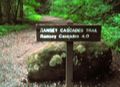
Trailhead
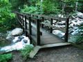
First bridge
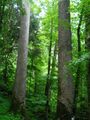
Old growth poplars
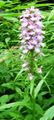
Purple Fringed Orchid


