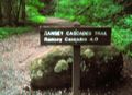
Trailhead is past large boulders and locked gate.
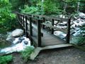
The trail follows a gravel logging road at first, then turns uphill to follow the stream to the waterfall.
National Park Service does trail maintenance primarily between May thru Nov, thus some blowdowns possible during the off-season. Can be very muddy after a significant rain.
No fee. Per NPS policy, no mountain bikes or dogs (if their owners cannot read the clearly posted signs).
Be aware that black bears are in the area.
Loading map...
{"type":"TERRAIN","minzoom":false,"maxzoom":false,"types":["ROADMAP","SATELLITE","HYBRID","TERRAIN"],"mappingservice":"googlemaps3","width":"auto","height":"550px","centre":{"text":"","title":"","link":"","lat":35.70700000000000073896444519050419330596923828125,"lon":-83.3299999999999982946974341757595539093017578125,"icon":""},"title":"","label":"","icon":"","lines":[],"polygons":[],"circles":[],"rectangles":[],"copycoords":false,"static":false,"visitedicon":"","wmsoverlay":false,"zoom":14,"layers":[],"controls":["pan","zoom","type","scale","streetview","rotate"],"zoomstyle":"DEFAULT","typestyle":"DEFAULT","autoinfowindows":false,"resizable":false,"kmlrezoom":false,"poi":true,"cluster":false,"clustergridsize":60,"clustermaxzoom":20,"clusterzoomonclick":true,"clusteraveragecenter":true,"clusterminsize":2,"imageoverlays":[],"kml":[],"gkml":["https://tehcc.org/clubwiki/kml/GSMNP_Ramsey_Cascades.kml"],"searchmarkers":"","fullscreen":false,"scrollwheelzoom":false,"locations":[{"text":"\u003Cdiv class=\"mw-parser-output\"\u003E\u003Cp\u003ETurn left to cross this bridge\n\u003C/p\u003E\u003C/div\u003E","title":"Turn left to cross this bridge\n","link":"","lat":35.70768000000000341742634191177785396575927734375,"lon":-83.3828800000000001091393642127513885498046875,"icon":"/clubwiki/images/MarkerL.png"},{"text":"\u003Cdiv class=\"mw-parser-output\"\u003E\u003Cp\u003EParking at trailhead gate\n\u003C/p\u003E\u003C/div\u003E","title":"Parking at trailhead gate\n","link":"","lat":35.7027700000000010049916454590857028961181640625,"lon":-83.357269999999999754436430521309375762939453125,"icon":"/clubwiki/images/MarkerA.png"},{"text":"\u003Cb\u003E\u003Cdiv class=\"mw-parser-output\"\u003E\u003Cp\u003EFirst trail bridge\n\u003C/p\u003E\u003C/div\u003E\u003C/b\u003E\u003Cdiv class=\"mw-parser-output\"\u003E\u003Cp\u003E\u003Ca href=\"/wiki/File:GSMNP_Ramsey_Cascades_Bridge1.JPG\" class=\"image\"\u003E\u003Cimg alt=\"GSMNP Ramsey Cascades Bridge1.JPG\" src=\"/clubwiki/images/thumb/GSMNP_Ramsey_Cascades_Bridge1.JPG/150px-GSMNP_Ramsey_Cascades_Bridge1.JPG\" decoding=\"async\" width=\"150\" height=\"113\" srcset=\"/clubwiki/images/thumb/GSMNP_Ramsey_Cascades_Bridge1.JPG/225px-GSMNP_Ramsey_Cascades_Bridge1.JPG 1.5x, /clubwiki/images/thumb/GSMNP_Ramsey_Cascades_Bridge1.JPG/300px-GSMNP_Ramsey_Cascades_Bridge1.JPG 2x\" data-file-width=\"448\" data-file-height=\"336\" /\u003E\u003C/a\u003E\n\u003C/p\u003E\u003C/div\u003E","title":"First trail bridge\n","link":"","lat":35.7029399999999981218934408389031887054443359375,"lon":-83.35674000000000205545802600681781768798828125,"icon":"/clubwiki/images/MarkerL.png"},{"text":"\u003Cb\u003E\u003Cdiv class=\"mw-parser-output\"\u003E\u003Cp\u003E2.5 miles left sign\n\u003C/p\u003E\u003C/div\u003E\u003C/b\u003E\u003Cdiv class=\"mw-parser-output\"\u003E\u003Cp\u003E\u003Ca href=\"/wiki/File:GSMNP_Ramsey_Cascades_two_and_half_miles.JPG\" class=\"image\" title=\"2.5 miles to go\"\u003E\u003Cimg alt=\"2.5 miles to go\" src=\"/clubwiki/images/thumb/GSMNP_Ramsey_Cascades_two_and_half_miles.JPG/150px-GSMNP_Ramsey_Cascades_two_and_half_miles.JPG\" decoding=\"async\" width=\"150\" height=\"113\" srcset=\"/clubwiki/images/thumb/GSMNP_Ramsey_Cascades_two_and_half_miles.JPG/225px-GSMNP_Ramsey_Cascades_two_and_half_miles.JPG 1.5x, /clubwiki/images/thumb/GSMNP_Ramsey_Cascades_two_and_half_miles.JPG/300px-GSMNP_Ramsey_Cascades_two_and_half_miles.JPG 2x\" data-file-width=\"448\" data-file-height=\"336\" /\u003E\u003C/a\u003E\n\u003C/p\u003E\u003C/div\u003E","title":"2.5 miles left sign\n","link":"","lat":35.7029500000000012960299500264227390289306640625,"lon":-83.334080000000000154614099301397800445556640625,"icon":"/clubwiki/images/MarkerT.png"},{"text":"\u003Cb\u003E\u003Cdiv class=\"mw-parser-output\"\u003E\u003Cp\u003ESecond trail bridge\n\u003C/p\u003E\u003C/div\u003E\u003C/b\u003E\u003Cdiv class=\"mw-parser-output\"\u003E\u003Cp\u003E\u003Ca href=\"/wiki/File:GSMNP_Ramsey_Cascades_Bridge2.JPG\" class=\"image\"\u003E\u003Cimg alt=\"GSMNP Ramsey Cascades Bridge2.JPG\" src=\"/clubwiki/images/thumb/GSMNP_Ramsey_Cascades_Bridge2.JPG/150px-GSMNP_Ramsey_Cascades_Bridge2.JPG\" decoding=\"async\" width=\"150\" height=\"147\" srcset=\"/clubwiki/images/thumb/GSMNP_Ramsey_Cascades_Bridge2.JPG/225px-GSMNP_Ramsey_Cascades_Bridge2.JPG 1.5x, /clubwiki/images/thumb/GSMNP_Ramsey_Cascades_Bridge2.JPG/300px-GSMNP_Ramsey_Cascades_Bridge2.JPG 2x\" data-file-width=\"342\" data-file-height=\"336\" /\u003E\u003C/a\u003E\n\u003C/p\u003E\u003C/div\u003E","title":"Second trail bridge\n","link":"","lat":35.70667999999999864257915760390460491180419921875,"lon":-83.325140000000004647517926059663295745849609375,"icon":"/clubwiki/images/MarkerL.png"},{"text":"\u003Cb\u003E\u003Cdiv class=\"mw-parser-output\"\u003E\u003Cp\u003EThird trail bridge\n\u003C/p\u003E\u003C/div\u003E\u003C/b\u003E\u003Cdiv class=\"mw-parser-output\"\u003E\u003Cp\u003E\u003Ca href=\"/wiki/File:GSMNP_Ramsey_Cascades_Bridge3.JPG\" class=\"image\"\u003E\u003Cimg alt=\"GSMNP Ramsey Cascades Bridge3.JPG\" src=\"/clubwiki/images/thumb/GSMNP_Ramsey_Cascades_Bridge3.JPG/150px-GSMNP_Ramsey_Cascades_Bridge3.JPG\" decoding=\"async\" width=\"150\" height=\"200\" srcset=\"/clubwiki/images/thumb/GSMNP_Ramsey_Cascades_Bridge3.JPG/225px-GSMNP_Ramsey_Cascades_Bridge3.JPG 1.5x, /clubwiki/images/thumb/GSMNP_Ramsey_Cascades_Bridge3.JPG/300px-GSMNP_Ramsey_Cascades_Bridge3.JPG 2x\" data-file-width=\"336\" data-file-height=\"448\" /\u003E\u003C/a\u003E\n\u003C/p\u003E\u003C/div\u003E","title":"Third trail bridge\n","link":"","lat":35.70918000000000347426976077258586883544921875,"lon":-83.314670000000006666596163995563983917236328125,"icon":"/clubwiki/images/MarkerL.png"},{"text":"\u003Cb\u003E\u003Cdiv class=\"mw-parser-output\"\u003E\u003Cp\u003EThree old growth poplars\n\u003C/p\u003E\u003C/div\u003E\u003C/b\u003E\u003Cdiv class=\"mw-parser-output\"\u003E\u003Cp\u003E\u003Ca href=\"/wiki/File:GSMNP_Ramsey_Cascades_old_growth.JPG\" class=\"image\"\u003E\u003Cimg alt=\"GSMNP Ramsey Cascades old growth.JPG\" src=\"/clubwiki/images/thumb/GSMNP_Ramsey_Cascades_old_growth.JPG/150px-GSMNP_Ramsey_Cascades_old_growth.JPG\" decoding=\"async\" width=\"150\" height=\"200\" srcset=\"/clubwiki/images/thumb/GSMNP_Ramsey_Cascades_old_growth.JPG/225px-GSMNP_Ramsey_Cascades_old_growth.JPG 1.5x, /clubwiki/images/thumb/GSMNP_Ramsey_Cascades_old_growth.JPG/300px-GSMNP_Ramsey_Cascades_old_growth.JPG 2x\" data-file-width=\"336\" data-file-height=\"448\" /\u003E\u003C/a\u003E\n\u003C/p\u003E\u003C/div\u003E","title":"Three old growth poplars\n","link":"","lat":35.7090400000000016689227777533233165740966796875,"lon":-83.32017999999999346982804127037525177001953125,"icon":"/clubwiki/images/MarkerD.png"},{"text":"\u003Cb\u003E\u003Cdiv class=\"mw-parser-output\"\u003E\u003Cp\u003ERamsey Cascades\n\u003C/p\u003E\u003C/div\u003E\u003C/b\u003E\u003Cdiv class=\"mw-parser-output\"\u003E\u003Cp\u003E\u003Ca href=\"/wiki/File:GSMNP_Ramsey_Cascades.JPG\" class=\"image\" title=\"Ramsey Cascades\"\u003E\u003Cimg alt=\"Ramsey Cascades\" src=\"/clubwiki/images/thumb/GSMNP_Ramsey_Cascades.JPG/150px-GSMNP_Ramsey_Cascades.JPG\" decoding=\"async\" width=\"150\" height=\"200\" srcset=\"/clubwiki/images/thumb/GSMNP_Ramsey_Cascades.JPG/225px-GSMNP_Ramsey_Cascades.JPG 1.5x, /clubwiki/images/thumb/GSMNP_Ramsey_Cascades.JPG/300px-GSMNP_Ramsey_Cascades.JPG 2x\" data-file-width=\"336\" data-file-height=\"448\" /\u003E\u003C/a\u003E\n\u003C/p\u003E\u003C/div\u003E","title":"Ramsey Cascades\n","link":"","lat":35.70855000000000245563569478690624237060546875,"lon":-83.300129999999995789039530791342258453369140625,"icon":"/clubwiki/images/MarkerC.png"}]}