|
|
| (2 intermediate revisions by the same user not shown) |
| Line 1: |
Line 1: |
| <!-- The following few lines create the "Infobox" table template. Please scroll down to edit the main content of the article. --> | | <!-- The following few lines create the "Infobox" table template. Please scroll down to edit the main content of the article. |
| {{Infobox Trail
| |
| | Image Name = GSMNP_Curry_Mountain_Trailhead.JPG
| |
| | City = Gatlinburg
| |
| | State = Tennessee
| |
| | Marking = None
| |
| | Trail Use = {{Hike}}
| |
| | Difficulty Rating = Medium
| |
| | Hike Time = 3-4
| |
| | Distance = 6.6
| |
| | Elevation Gain = 945
| |
| | High Point = 2775
| |
| | Latitude = 35.675483
| |
| | Longitude = -83.646433
| |
| | Medical = Sevierville
| |
| }}
| |
| <!-- End Infobox template table-->
| |
|
| |
|
| <!-- Start of Main Page --> | | -->{{Infobox Trail |
| | | Image Name = GSMNP_Curry_Mountain_Trailhead.JPG |
| | | Park = Great Smoky Mountains National Park |
| | | City = Gatlinburg |
| | | State = Tennessee |
| | | Marking = None |
| | | Trail Use = {{Hike}} |
| | | Difficulty Rating = Medium |
| | | Hike Time = 3.5 Hours |
| | | Round Trip Distance = 6.64 Mi |
| | | Trail Distance = 3.32 Mi |
| | | Trail Type = In-and-Out |
| | | Elevation Gain = 2,162 Ft |
| | | Elevation Loss = -1,029 Ft |
| | | High Point = 2,906 Ft |
| | | Parking coords = 35.677075,-83.647175 |
| | | Trailhead coords = 35.675483,-83.646433 |
| | | Medical = Sevierville |
| | }}<!-- |
|
| |
|
| | End Infobox template table |
| | |
| | -->{{Trail page needs |
| | | Hide needs = Yes |
| | | KML = |
| | | Updated KML = |
| | | Detail route description = |
| | | Photos = |
| | | Winter photos = |
| | | Remove prefix = Yes |
| | | Update infobox = |
| | | Infobox data update = |
| | | Trail pins = |
| | | Other = |
| | | Comment = Looks good |
| | | Date reviewed = 10/25/2015 |
| | }}<!-- |
| | |
| | Start of Main Page --> |
| == Trail Overview == | | == Trail Overview == |
| <!-- Enter a overview of the trail. What attracts you to this trail, points of interest, types of flowers, lakes, and peaks that you see along the way. --> | | <!-- Enter a overview of the trail. What attracts you to this trail, points of interest, types of flowers, lakes, and peaks that you see along the way. --> |
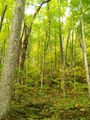
| Located in the [[Great Smoky Mountains National Park]], a lesser used trail up a former logging road affording solitude. Continue a bit further to find a small cemetery. | | Located in the [[Great Smoky Mountains National Park]], a lesser used trail up a former logging road affording solitude. Continue a bit farther to find a small cemetery. |
|
| |
|
| == How to get there == | | == How to get there == |
| Line 79: |
Line 100: |
| <!-- You can place pictures, PDF's, links, or even create a Google map with your waypoints and place it here. --> | | <!-- You can place pictures, PDF's, links, or even create a Google map with your waypoints and place it here. --> |
| <!-- Ready for the KML to be uploaded --> | | <!-- Ready for the KML to be uploaded --> |
| <googlemap version="0.9" lat="35.66" lon="-83.646433" type="terrain" zoom="14" width="750" height="600" scale="yes" controls="medium" icons="http://tehcc.org/clubwiki/kml/marker{label}.png"> | | <display_map center="35.66,-83.646433" type="terrain" zoom="14" width="auto" height="600" gkml="https://tehcc.org/clubwiki/kml/GSMNP_Curry_Mountain_Trail.kml"> |
| http://tehcc.org/clubwiki/kml/GSMNP_Curry_Mountain_Trail.kml
| | |
| (A) 35.674517,-83.645917
| | 35.674517,-83.645917~Parking along Little River Gorge Road~ ~MarkerA.png |
| Parking along Little River Gorge Road | | 35.677075,-83.647175~Parking at Metcalf Bottoms picnic area~ ~MarkerA.png |
| (A) 35.677075,-83.647175
| | 35.675483,-83.646433~Trailhead on Little River Gorge Road~ ~MarkerT.png |
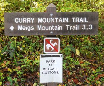
| Parking at Metcalf Bottoms picnic area | | 35.645305,-83.635093~Upper trailhead intersection with Meigs Mtn Trail~[[Image:GSMNP Curry Mtn_Meigs Mtn.JPG|150px|]]~MarkerT.png |
| (G) 35.675483,-83.646433
| | 35.643083,-83.636950~Meigs Mountain Cemetery~ ~MarkerN.png |
| Trailhead on Little River Gorge Road | | </display_map> |
| (G) 35.645305,-83.635093
| |
| Upper trailhead intersection with Meigs Mtn Trail | |
| [[Image:GSMNP Curry Mtn_Meigs Mtn.JPG|150px|]] | |
| (N) 35.643083,-83.636950
| |
| Meigs Mountain Cemetery | |
| </googlemap> | |
|
| |
|
| == Photos == | | == Photos == |
|
|
|
|
|
| Trail Name
|
GSMNP Curry Mountain Trail
|
| Park
|
Great Smoky Mountains National Park
|
| Nearest City
|
Gatlinburg
|
| State
|
Tennessee
|
| Trail Marking
|
None
|
| Trail Use/Features
|

|
| Difficulty Rating
|
Medium
|
| Hiking Time
|
3.5 Hours0.219 Days <br />210 Min <br />
|
Distance:
round-trip/trail only
|
6.64 Mi10.686 km <br /> / 3.32 Mi5.343 km <br />
|
| Trail Type
|
In-and-Out
|
| Climb/Descent Elevation
|
2,162 Ft658.978 Meters <br /> / -1,029 Ft-313.639 Meters <br />
|
| High Point
|
2,906 Ft968.667 Yards <br />885.749 Meters <br />
|
| Parking
|
35° 40' 37.47" N, 83° 38' 49.83" W
|
| Trailhead
|
35° 40' 31.74" N, 83° 38' 47.16" W
|
| Nearest Medical
|
Sevierville
|
| Trip Reports
|
Click Here
|
|
|
Loading map... {"type":"ROADMAP","minzoom":false,"maxzoom":false,"types":["ROADMAP","SATELLITE","HYBRID","TERRAIN"],"mappingservice":"googlemaps3","width":"270px","height":"180px","centre":false,"title":"","label":"","icon":"","lines":[],"polygons":[],"circles":[],"rectangles":[],"copycoords":false,"static":false,"visitedicon":"","wmsoverlay":false,"zoom":8,"layers":[],"controls":["zoom"],"zoomstyle":"DEFAULT","typestyle":"DEFAULT","autoinfowindows":false,"resizable":false,"kmlrezoom":false,"poi":true,"cluster":false,"clustergridsize":60,"clustermaxzoom":20,"clusterzoomonclick":true,"clusteraveragecenter":true,"clusterminsize":2,"imageoverlays":[],"kml":[],"gkml":[],"searchmarkers":"","fullscreen":false,"scrollwheelzoom":false,"locations":[{"text":"","title":"","link":"","lat":35.67707500000000209183781407773494720458984375,"lon":-83.64717500000000427462509833276271820068359375,"icon":""}]} |
|
| Show Large Map
|
|
Trail Overview[edit]
Located in the Great Smoky Mountains National Park, a lesser used trail up a former logging road affording solitude. Continue a bit farther to find a small cemetery.
How to get there[edit]
From Pigeon Forge, TN:
- Take US321 South/Wears Valley Rd out of town from Light #3.
- Drive nine winding miles, and then take left/south onto Lyon Springs Rd.
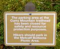
- Enter the Great Smoky Mountains National Park at Metcalf Bottoms.
- Continue along roadway over one-lane wooden bridge.
- Turn left/east to enter picnic area and park along loop. There is no parking at the trailhead. Alternative is five spaces further each along the main park roadway.
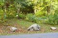
Trailhead is past small boulders.
Route Description[edit]
The trail follows a former logging road up and up Curry Mountain.
| Distance (mi)
|
Elevation (ft)
|
Description
|
| 0.0
|
1830
|
Trailhead
|
| 0.6
|
2020
|
Sharp turn right. First of views.
|
| 1.4
|
2300
|
More views of the valley
|
| 3.3
|
2775
|
Intersect Meigs Mountain Trail between Elkmont and Treemont
|
Typical Conditions[edit]
National Park Service does trail maintenance primarily between May thru Nov, thus some blowdowns possible during the off-season. While the trail crosses a few drainages with stepping stones, the tread indicated it can be a downhill stream after a significant rain.
Fees, Permits, etc.[edit]
No fee. Per NPS policy, no mountain bikes or dogs. Posted for no horses.
After the Hike[edit]
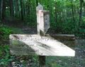
Head west on Meigs Mountain trail to reach a small cemetery.
Misc. Information[edit]
Be aware that black bears are in the area.
Loading map...
{"type":"TERRAIN","minzoom":false,"maxzoom":false,"types":["ROADMAP","SATELLITE","HYBRID","TERRAIN"],"mappingservice":"googlemaps3","width":"auto","height":"600px","centre":{"text":"","title":"","link":"","lat":35.659999999999996589394868351519107818603515625,"lon":-83.6464330000000018117134459316730499267578125,"icon":""},"title":"","label":"","icon":"","lines":[],"polygons":[],"circles":[],"rectangles":[],"copycoords":false,"static":false,"visitedicon":"","wmsoverlay":false,"zoom":14,"layers":[],"controls":["pan","zoom","type","scale","streetview","rotate"],"zoomstyle":"DEFAULT","typestyle":"DEFAULT","autoinfowindows":false,"resizable":false,"kmlrezoom":false,"poi":true,"cluster":false,"clustergridsize":60,"clustermaxzoom":20,"clusterzoomonclick":true,"clusteraveragecenter":true,"clusterminsize":2,"imageoverlays":[],"kml":[],"gkml":["https://tehcc.org/clubwiki/kml/GSMNP_Curry_Mountain_Trail.kml"],"searchmarkers":"","fullscreen":false,"scrollwheelzoom":false,"locations":[{"text":"\u003Cdiv class=\"mw-parser-output\"\u003E\u003Cp\u003EParking along Little River Gorge Road\n\u003C/p\u003E\u003C/div\u003E","title":"Parking along Little River Gorge Road\n","link":"","lat":35.67451700000000158752300194464623928070068359375,"lon":-83.64591699999999718784238211810588836669921875,"icon":"/clubwiki/images/MarkerA.png"},{"text":"\u003Cdiv class=\"mw-parser-output\"\u003E\u003Cp\u003EParking at Metcalf Bottoms picnic area\n\u003C/p\u003E\u003C/div\u003E","title":"Parking at Metcalf Bottoms picnic area\n","link":"","lat":35.67707500000000209183781407773494720458984375,"lon":-83.64717500000000427462509833276271820068359375,"icon":"/clubwiki/images/MarkerA.png"},{"text":"\u003Cdiv class=\"mw-parser-output\"\u003E\u003Cp\u003ETrailhead on Little River Gorge Road\n\u003C/p\u003E\u003C/div\u003E","title":"Trailhead on Little River Gorge Road\n","link":"","lat":35.6754829999999998335624695755541324615478515625,"lon":-83.6464330000000018117134459316730499267578125,"icon":"/clubwiki/images/MarkerT.png"},{"text":"\u003Cb\u003E\u003Cdiv class=\"mw-parser-output\"\u003E\u003Cp\u003EUpper trailhead intersection with Meigs Mtn Trail\n\u003C/p\u003E\u003C/div\u003E\u003C/b\u003E\u003Cdiv class=\"mw-parser-output\"\u003E\u003Cp\u003E\u003Ca href=\"/clubwiki/index.php?title=Special:Upload\u0026amp;wpDestFile=GSMNP_Curry_Mtn_Meigs_Mtn.JPG\" class=\"new\" title=\"File:GSMNP Curry Mtn Meigs Mtn.JPG\"\u003EFile:GSMNP Curry Mtn Meigs Mtn.JPG\u003C/a\u003E\n\u003C/p\u003E\u003C/div\u003E","title":"Upper trailhead intersection with Meigs Mtn Trail\n","link":"","lat":35.64530500000000046156856114976108074188232421875,"lon":-83.6350929999999976871549733914434909820556640625,"icon":"/clubwiki/images/MarkerT.png"},{"text":"\u003Cdiv class=\"mw-parser-output\"\u003E\u003Cp\u003EMeigs Mountain Cemetery\n\u003C/p\u003E\u003C/div\u003E","title":"Meigs Mountain Cemetery\n","link":"","lat":35.64308299999999718465915066190063953399658203125,"lon":-83.6369499999999987949195201508700847625732421875,"icon":"/clubwiki/images/MarkerN.png"}]}