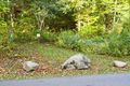
Trailhead is past small boulders.
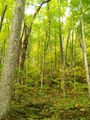
The trail follows a former logging road up and up Curry Mountain.
National Park Service does trail maintenance primarily between May thru Nov, thus some blowdowns possible during the off-season. While the trail crosses a few drainages with stepping stones, the tread indicated it can be a downhill stream after a significant rain.
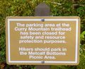
No fee. Per NPS policy, no mountain bikes or dogs. Posted for no horses.
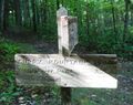
Head west on Meigs Mountain trail to reach a small cemetery.
Be aware that black bears are in the area.
Loading map...
{"type":"TERRAIN","minzoom":false,"maxzoom":false,"types":["ROADMAP","SATELLITE","HYBRID","TERRAIN"],"mappingservice":"googlemaps3","width":"auto","height":"600px","centre":{"text":"","title":"","link":"","lat":35.659999999999996589394868351519107818603515625,"lon":-83.6464330000000018117134459316730499267578125,"icon":""},"title":"","label":"","icon":"","lines":[],"polygons":[],"circles":[],"rectangles":[],"copycoords":false,"static":false,"visitedicon":"","wmsoverlay":false,"zoom":14,"layers":[],"controls":["pan","zoom","type","scale","streetview","rotate"],"zoomstyle":"DEFAULT","typestyle":"DEFAULT","autoinfowindows":false,"resizable":false,"kmlrezoom":false,"poi":true,"cluster":false,"clustergridsize":60,"clustermaxzoom":20,"clusterzoomonclick":true,"clusteraveragecenter":true,"clusterminsize":2,"imageoverlays":[],"kml":[],"gkml":["https://tehcc.org/clubwiki/kml/GSMNP_Curry_Mountain_Trail.kml"],"searchmarkers":"","fullscreen":false,"scrollwheelzoom":false,"locations":[{"text":"\u003Cdiv class=\"mw-parser-output\"\u003E\u003Cp\u003EParking along Little River Gorge Road\n\u003C/p\u003E\u003C/div\u003E","title":"Parking along Little River Gorge Road\n","link":"","lat":35.67451700000000158752300194464623928070068359375,"lon":-83.64591699999999718784238211810588836669921875,"icon":"/clubwiki/images/MarkerA.png"},{"text":"\u003Cdiv class=\"mw-parser-output\"\u003E\u003Cp\u003EParking at Metcalf Bottoms picnic area\n\u003C/p\u003E\u003C/div\u003E","title":"Parking at Metcalf Bottoms picnic area\n","link":"","lat":35.67707500000000209183781407773494720458984375,"lon":-83.64717500000000427462509833276271820068359375,"icon":"/clubwiki/images/MarkerA.png"},{"text":"\u003Cdiv class=\"mw-parser-output\"\u003E\u003Cp\u003ETrailhead on Little River Gorge Road\n\u003C/p\u003E\u003C/div\u003E","title":"Trailhead on Little River Gorge Road\n","link":"","lat":35.6754829999999998335624695755541324615478515625,"lon":-83.6464330000000018117134459316730499267578125,"icon":"/clubwiki/images/MarkerT.png"},{"text":"\u003Cb\u003E\u003Cdiv class=\"mw-parser-output\"\u003E\u003Cp\u003EUpper trailhead intersection with Meigs Mtn Trail\n\u003C/p\u003E\u003C/div\u003E\u003C/b\u003E\u003Cdiv class=\"mw-parser-output\"\u003E\u003Cp\u003E\u003Ca href=\"/clubwiki/index.php?title=Special:Upload\u0026amp;wpDestFile=GSMNP_Curry_Mtn_Meigs_Mtn.JPG\" class=\"new\" title=\"File:GSMNP Curry Mtn Meigs Mtn.JPG\"\u003EFile:GSMNP Curry Mtn Meigs Mtn.JPG\u003C/a\u003E\n\u003C/p\u003E\u003C/div\u003E","title":"Upper trailhead intersection with Meigs Mtn Trail\n","link":"","lat":35.64530500000000046156856114976108074188232421875,"lon":-83.6350929999999976871549733914434909820556640625,"icon":"/clubwiki/images/MarkerT.png"},{"text":"\u003Cdiv class=\"mw-parser-output\"\u003E\u003Cp\u003EMeigs Mountain Cemetery\n\u003C/p\u003E\u003C/div\u003E","title":"Meigs Mountain Cemetery\n","link":"","lat":35.64308299999999718465915066190063953399658203125,"lon":-83.6369499999999987949195201508700847625732421875,"icon":"/clubwiki/images/MarkerN.png"}]}