|
|
|
|
|
| Trail Name
|
Fire Tower Trail
|
| Nearest City
|
Kingsport
|
| State
|
Tennessee
|
| Trail Marking
|
{{{Marking}}}
|
| Trail Use/Features
|
 
|
| Difficulty Rating
|
Medium
|
| Hiking Time
|
0.50.5 Hours <br />0.0313 Days <br />30 Min <br />
|
| Distance, round-trip
|
0.70.7 mi <br />1.127 km <br />
|
| Climb/Descent Elevation
|
860860 Feet <br />262.128 Meters <br /> / {{{Elevation Loss}}}"{{{Elevation Loss}}}" is not a number.
|
| High Point
|
24052,405 Feet <br />801.667 Yards <br />733.044 Meters <br />
|
| Nearest Medical
|
Kingsport, TN
|
| Trip Reports
|
Click Here
|
|
|
Loading map... {"type":"ROADMAP","minzoom":false,"maxzoom":false,"types":["ROADMAP","SATELLITE","HYBRID","TERRAIN"],"mappingservice":"googlemaps3","width":"270px","height":"180px","centre":false,"title":"","label":"","icon":"","lines":[],"polygons":[],"circles":[],"rectangles":[],"copycoords":false,"static":false,"visitedicon":"","wmsoverlay":false,"zoom":8,"layers":[],"controls":["zoom"],"zoomstyle":"DEFAULT","typestyle":"DEFAULT","autoinfowindows":false,"resizable":false,"kmlrezoom":false,"poi":true,"cluster":false,"clustergridsize":60,"clustermaxzoom":20,"clusterzoomonclick":true,"clusteraveragecenter":true,"clusterminsize":2,"imageoverlays":[],"kml":[],"gkml":[],"searchmarkers":"","fullscreen":false,"scrollwheelzoom":false,"locations":[{"text":"","title":"","link":"","lat":36.51551930000000112386260298080742359161376953125,"lon":-82.624166599999995241887518204748630523681640625,"icon":""}]} |
|
| Show Large Map
|
|
Trail Overview
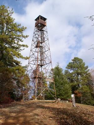
Located in Bays Mountain Park. Second most popular trail (after Lakeside Trail) up to the firetower for view across Holston Defense, west end of Kingsport, and into Virginia.
How to get there
Take Lakeside Trail clockwise around the reservior or BMP Lake Road counterclockwise. The lower trailhead in on Lake Road.
Alternatively, the upper trailhead at the firetower is reached on River Mountain Road from either the antennas or Fegins Gap.
Route Description
From parking lot, roughly 2 miles taking 60 minutes to reach firetower. Return trip down is faster.
Typical Conditions
Well worn dirt trail with few blowdowns. Please do not cut through the switchbacks.
Regulations
NO BIKES!
Misc. Information
The 60' firetower was constructed by the Civilian Conservation Corps (CCC) in 1937.
Maps
<googlemap version="0.9" lat="36.51545" lon="-82.62378" type="terrain" zoom="15" width="700" scale="yes" icons="http://tehcc.org/clubwiki/kml/marker{label}.png">
http://tehcc.org/clubwiki/kml/BMP_Firetower_Trail.kml
(G) 36.51, -82.62378,Firetower Trail
(E) 36.51545, -82.62378
Garden Mountain/Kingsport Lookout Tower
</googlemap>
Photos
