Loading map...
{"format":"googlemaps3","type":"TERRAIN","minzoom":false,"maxzoom":false,"types":["SATELLITE","HYBRID","TERRAIN"],"limit":50,"offset":0,"link":"none","sort":[""],"order":[],"headers":"show","mainlabel":"","intro":"","outro":"","searchlabel":"... further results","default":"","import-annotation":false,"width":"auto","height":"600px","centre":false,"title":"","label":"","icon":"","lines":[],"polygons":[],"circles":[],"rectangles":[],"copycoords":false,"static":false,"visitedicon":"","wmsoverlay":false,"zoom":false,"layers":[],"controls":["pan","zoom","type","scale","streetview","rotate"],"zoomstyle":"DEFAULT","typestyle":"DEFAULT","autoinfowindows":false,"resizable":false,"kmlrezoom":true,"poi":true,"cluster":false,"clustergridsize":60,"clustermaxzoom":20,"clusterzoomonclick":true,"clusteraveragecenter":true,"clusterminsize":2,"imageoverlays":[],"kml":[],"gkml":["https://tehcc.org/clubwiki/images/Fire_Tower_Trail.kml","https://tehcc.org/clubwiki/images/Lake_Road_(Bays_Mountain_Park).kml","https://tehcc.org/clubwiki/images/River_Mountain_Road.kml"],"searchmarkers":"","fullscreen":false,"scrollwheelzoom":false,"showtitle":false,"hidenamespace":true,"template":"Map Balloon Template","userparam":"","activeicon":"","pagelabel":false,"ajaxcoordproperty":"","ajaxquery":"","locations":[{"text":"\u003Cp\u003E\u003Cb\u003E\u003Ca class=\"mw-selflink selflink\"\u003EFire Tower Trail\u003C/a\u003E\u003C/b\u003E\u003Cbr /\u003E\u003C/p\u003E\u003Chr /\u003E\u003Cp\u003E0.70\u0026#160;Mi (1.13\u0026#160;km)\u003Cbr /\u003EDifficulty: Medium\u003Cbr /\u003EMarking: Signs\u003C/p\u003E","title":"Fire Tower Trail","link":"","lat":36.51201999999999969759301166050136089324951171875,"lon":-82.61669000000000551153789274394512176513671875,"icon":"/clubwiki/images/MarkerT.png"},{"text":"\u003Cp\u003E\u003Cb\u003EGarden Mountain/Kingsport Lookout Tower\u003C/b\u003E\u003Cbr /\u003E\u003C/p\u003E\u003Chr /\u003E\u003Cp\u003E\u003Ca href=\"/wiki/File:BMP_Firetower_Trail_tower.jpg\" class=\"image\" title=\"Fire tower\"\u003E\u003Cimg alt=\"Fire tower\" src=\"/clubwiki/images/thumb/BMP_Firetower_Trail_tower.jpg/150px-BMP_Firetower_Trail_tower.jpg\" decoding=\"async\" width=\"150\" height=\"201\" srcset=\"/clubwiki/images/thumb/BMP_Firetower_Trail_tower.jpg/225px-BMP_Firetower_Trail_tower.jpg 1.5x, /clubwiki/images/BMP_Firetower_Trail_tower.jpg 2x\" data-file-width=\"300\" data-file-height=\"401\" /\u003E\u003C/a\u003E\u003C/p\u003E","title":"Fire Tower Trail","link":"","lat":36.5154500000000012960299500264227390289306640625,"lon":-82.6238000000000027966962079517543315887451171875,"icon":"/clubwiki/images/MarkerE.png"},{"text":"\u003Cp\u003E\u003Cb\u003EJunction with \u003Ca href=\"/wiki/Lake_Road_(Bays_Mountain_Park)\" title=\"Lake Road (Bays Mountain Park)\"\u003ELake Road\u003C/a\u003E\u003C/b\u003E\u003Cbr /\u003E\u003C/p\u003E\u003Chr /\u003E\u003Cp\u003EJunction with \u003Ca href=\"/wiki/Lake_Road_(Bays_Mountain_Park)\" title=\"Lake Road (Bays Mountain Park)\"\u003ELake Road\u003C/a\u003E\u003C/p\u003E","title":"Fire Tower Trail","link":"","lat":36.51201999999999969759301166050136089324951171875,"lon":-82.61669000000000551153789274394512176513671875,"icon":"/clubwiki/images/MarkerG.png"},{"text":"\u003Cp\u003E\u003Cb\u003E\u003Ca href=\"/wiki/Lake_Road_(Bays_Mountain_Park)\" title=\"Lake Road (Bays Mountain Park)\"\u003ELake Road (Bays Mountain Park)\u003C/a\u003E\u003C/b\u003E\u003Cbr /\u003E\u003C/p\u003E\u003Chr /\u003E\u003Cp\u003E4.33\u0026#160;Mi (6.96\u0026#160;km)\u003Cbr /\u003EDifficulty: Easy\u003Cbr /\u003EMarking: Signs\u003C/p\u003E","title":"Lake Road (Bays Mountain Park)","link":"","lat":36.50645999999999702367858844809234142303466796875,"lon":-82.63128000000000383806764148175716400146484375,"icon":"/clubwiki/images/MarkerT.png"},{"text":"\u003Cp\u003E\u003Cb\u003ELedbetter Gap\u003C/b\u003E\u003Cbr /\u003E\u003C/p\u003E\u003Chr /\u003E\u003Cp\u003E\u003Ca href=\"/wiki/File:BMP_Ledbetter_Gap_sign.JPG\" class=\"image\"\u003E\u003Cimg alt=\"BMP Ledbetter Gap sign.JPG\" src=\"/clubwiki/images/thumb/BMP_Ledbetter_Gap_sign.JPG/150px-BMP_Ledbetter_Gap_sign.JPG\" decoding=\"async\" width=\"150\" height=\"148\" srcset=\"/clubwiki/images/thumb/BMP_Ledbetter_Gap_sign.JPG/225px-BMP_Ledbetter_Gap_sign.JPG 1.5x, /clubwiki/images/thumb/BMP_Ledbetter_Gap_sign.JPG/300px-BMP_Ledbetter_Gap_sign.JPG 2x\" data-file-width=\"340\" data-file-height=\"336\" /\u003E\u003C/a\u003E\u003Cbr /\u003ECrossroads with \u003Ca href=\"/wiki/Bays_Ridge_Road\" title=\"Bays Ridge Road\"\u003EBays Ridge Road\u003C/a\u003E and \u003Ca href=\"/wiki/Front_Hollow_Road\" title=\"Front Hollow Road\"\u003EFront Hollow Road\u003C/a\u003E\u003C/p\u003E","title":"Lake Road (Bays Mountain Park)","link":"","lat":36.4979000000000013415046851150691509246826171875,"lon":-82.627712999999999965439201332628726959228515625,"icon":"/clubwiki/images/MarkerT.png"},{"text":"\u003Cp\u003E\u003Cb\u003E\u003Ca href=\"/wiki/Orchid_Trail\" title=\"Orchid Trail\"\u003EOrchid Trail\u003C/a\u003E\u003C/b\u003E\u003Cbr /\u003E\u003C/p\u003E\u003Chr /\u003E\u003Cp\u003E\u003Ca href=\"/wiki/File:BMP_Orchid_Trail_sign.JPG\" class=\"image\"\u003E\u003Cimg alt=\"BMP Orchid Trail sign.JPG\" src=\"/clubwiki/images/thumb/BMP_Orchid_Trail_sign.JPG/50px-BMP_Orchid_Trail_sign.JPG\" decoding=\"async\" width=\"50\" height=\"89\" srcset=\"/clubwiki/images/thumb/BMP_Orchid_Trail_sign.JPG/75px-BMP_Orchid_Trail_sign.JPG 1.5x, /clubwiki/images/thumb/BMP_Orchid_Trail_sign.JPG/100px-BMP_Orchid_Trail_sign.JPG 2x\" data-file-width=\"252\" data-file-height=\"448\" /\u003E\u003C/a\u003E\u003C/p\u003E","title":"Lake Road (Bays Mountain Park)","link":"","lat":36.50348999999999932697392068803310394287109375,"lon":-82.618930000000005975380190648138523101806640625,"icon":"/clubwiki/images/MarkerT.png"},{"text":"\u003Cp\u003E\u003Cb\u003ECrossroads\u003C/b\u003E\u003Cbr /\u003E\u003C/p\u003E\u003Chr /\u003E\u003Cp\u003E\u003Ca href=\"/wiki/Back_Hollow_Road\" title=\"Back Hollow Road\"\u003EBack Hollow Road\u003C/a\u003E and \u003Ca href=\"/wiki/River_Mountain_Road\" title=\"River Mountain Road\"\u003ERiver Mountain Road\u003C/a\u003E\u003C/p\u003E","title":"Lake Road (Bays Mountain Park)","link":"","lat":36.50654800000000221871232497505843639373779296875,"lon":-82.6312779999999946767275105230510234832763671875,"icon":"/clubwiki/images/MarkerT.png"},{"text":"\u003Cp\u003E\u003Cb\u003EOld quarry used for stone to create reservoir dam\u003C/b\u003E\u003Cbr /\u003E\u003C/p\u003E\u003Chr /\u003E\u003Cp\u003EOld quarry used for stone to create reservoir dam\u003C/p\u003E","title":"Lake Road (Bays Mountain Park)","link":"","lat":36.50513000000000118916432256810367107391357421875,"lon":-82.6295300000000025875124265439808368682861328125,"icon":"/clubwiki/images/MarkerD.png"},{"text":"\u003Cp\u003E\u003Cb\u003E\u003Ca href=\"/wiki/Cherry_Knobs\" title=\"Cherry Knobs\"\u003ECherry Knobs\u003C/a\u003E\u003C/b\u003E\u003Cbr /\u003E\u003C/p\u003E\u003Chr /\u003E\u003Cp\u003E\u003Ca href=\"/wiki/Cherry_Knobs\" title=\"Cherry Knobs\"\u003ECherry Knobs\u003C/a\u003E\u003C/p\u003E","title":"Lake Road (Bays Mountain Park)","link":"","lat":36.50344799999999878536982578225433826446533203125,"lon":-82.6285299999999978126652422361075878143310546875,"icon":"/clubwiki/images/MarkerT.png"},{"text":"\u003Cp\u003E\u003Cb\u003E\u003Ca href=\"/wiki/Pine_Trail\" title=\"Pine Trail\"\u003EPine Trail\u003C/a\u003E\u003C/b\u003E\u003Cbr /\u003E\u003C/p\u003E\u003Chr /\u003E\u003Cp\u003E\u003Ca href=\"/wiki/Pine_Trail\" title=\"Pine Trail\"\u003EPine Trail\u003C/a\u003E\u003C/p\u003E","title":"Lake Road (Bays Mountain Park)","link":"","lat":36.50708800000000309182723867706954479217529296875,"lon":-82.61354000000000041836756281554698944091796875,"icon":"/clubwiki/images/MarkerT.png"},{"text":"\u003Cp\u003E\u003Cb\u003EJunction with \u003Ca href=\"/wiki/Chinquapin_Trail\" title=\"Chinquapin Trail\"\u003EChinquapin Trail\u003C/a\u003E\u003C/b\u003E\u003Cbr /\u003E\u003C/p\u003E\u003Chr /\u003E\u003Cp\u003EJunction with \u003Ca href=\"/wiki/Chinquapin_Trail\" title=\"Chinquapin Trail\"\u003EChinquapin Trail\u003C/a\u003E\u003C/p\u003E","title":"Lake Road (Bays Mountain Park)","link":"","lat":36.50945999999999713736542616970837116241455078125,"lon":-82.62130999999999403371475636959075927734375,"icon":"/clubwiki/images/MarkerT.png"},{"text":"\u003Cp\u003E\u003Cb\u003E\u003Ca href=\"/wiki/Cherry_Knobs\" title=\"Cherry Knobs\"\u003ECherry Knobs\u003C/a\u003E\u003C/b\u003E\u003Cbr /\u003E\u003C/p\u003E\u003Chr /\u003E\u003Cp\u003E\u003Ca href=\"/wiki/Cherry_Knobs\" title=\"Cherry Knobs\"\u003ECherry Knobs\u003C/a\u003E\u003C/p\u003E","title":"Lake Road (Bays Mountain Park)","link":"","lat":36.50097199999999730835043010301887989044189453125,"lon":-82.6309739999999948167896945960819721221923828125,"icon":"/clubwiki/images/MarkerT.png"},{"text":"\u003Cp\u003E\u003Cb\u003E\u003Ca href=\"/wiki/Bays_Ridge_Road\" title=\"Bays Ridge Road\"\u003EBays Ridge Road\u003C/a\u003E\u003C/b\u003E\u003Cbr /\u003E\u003C/p\u003E\u003Chr /\u003E\u003Cp\u003E\u003Ca href=\"/wiki/File:BMP_LakeRd-BaysRidgeRd_sign.JPG\" class=\"image\"\u003E\u003Cimg alt=\"BMP LakeRd-BaysRidgeRd sign.JPG\" src=\"/clubwiki/images/thumb/BMP_LakeRd-BaysRidgeRd_sign.JPG/50px-BMP_LakeRd-BaysRidgeRd_sign.JPG\" decoding=\"async\" width=\"50\" height=\"179\" srcset=\"/clubwiki/images/thumb/BMP_LakeRd-BaysRidgeRd_sign.JPG/75px-BMP_LakeRd-BaysRidgeRd_sign.JPG 1.5x, /clubwiki/images/thumb/BMP_LakeRd-BaysRidgeRd_sign.JPG/100px-BMP_LakeRd-BaysRidgeRd_sign.JPG 2x\" data-file-width=\"125\" data-file-height=\"448\" /\u003E\u003C/a\u003E\u003C/p\u003E","title":"Lake Road (Bays Mountain Park)","link":"","lat":36.50761299999999920373738859780132770538330078125,"lon":-82.6126579999999961501089273951947689056396484375,"icon":"/clubwiki/images/MarkerT.png"},{"text":"\u003Cp\u003E\u003Cb\u003E\u003Ca href=\"/wiki/River_Mountain_Road\" title=\"River Mountain Road\"\u003ERiver Mountain Road\u003C/a\u003E\u003C/b\u003E\u003Cbr /\u003E\u003C/p\u003E\u003Chr /\u003E\u003Cp\u003E3.21\u0026#160;Mi (5.16\u0026#160;km)\u003Cbr /\u003EDifficulty: Medium\u003Cbr /\u003EMarking: Signs\u003C/p\u003E","title":"River Mountain Road","link":"","lat":36.5166100000000000136424205265939235687255859375,"lon":-82.609340000000003101376933045685291290283203125,"icon":"/clubwiki/images/MarkerT.png"},{"text":"\u003Cp\u003E\u003Cb\u003E1937 CCC Built Fire Tower\u003C/b\u003E\u003Cbr /\u003E\u003C/p\u003E\u003Chr /\u003E\u003Cp\u003E1937 CCC Built Fire Tower\u003C/p\u003E","title":"River Mountain Road","link":"","lat":36.51547000000000053887561080045998096466064453125,"lon":-82.6241639999999932797436485998332500457763671875,"icon":"/clubwiki/images/MarkerE.png"},{"text":"\u003Cp\u003E\u003Cb\u003EComm Tower\u003C/b\u003E\u003Cbr /\u003E\u003C/p\u003E\u003Chr /\u003E\u003Cp\u003EComm Tower\u003C/p\u003E","title":"River Mountain Road","link":"","lat":36.52386200000000116006049211136996746063232421875,"lon":-82.59611599999999498322722502052783966064453125,"icon":"/clubwiki/images/MarkerM.png"},{"text":"\u003Cp\u003E\u003Cb\u003E\u003Ca href=\"/wiki/Indian_Pipes_Trail\" title=\"Indian Pipes Trail\"\u003EIndian Pipes Trail\u003C/a\u003E\u003C/b\u003E\u003Cbr /\u003E\u003C/p\u003E\u003Chr /\u003E\u003Cp\u003E\u003Ca href=\"/wiki/Indian_Pipes_Trail\" title=\"Indian Pipes Trail\"\u003EIndian Pipes Trail\u003C/a\u003E\u003C/p\u003E","title":"River Mountain Road","link":"","lat":36.51359000000000065710992203094065189361572265625,"lon":-82.6276270000000039317455957643687725067138671875,"icon":"/clubwiki/images/MarkerT.png"},{"text":"\u003Cp\u003E\u003Cb\u003E\u003Ca href=\"/wiki/Azalea\" title=\"Azalea\"\u003EAzalea Trail\u003C/a\u003E\u003C/b\u003E\u003Cbr /\u003E\u003C/p\u003E\u003Chr /\u003E\u003Cp\u003E\u003Ca href=\"/wiki/Azalea\" title=\"Azalea\"\u003EAzalea Trail\u003C/a\u003E\u003C/p\u003E","title":"River Mountain Road","link":"","lat":36.52616299999999682768248021602630615234375,"lon":-82.58778200000000424552126787602901458740234375,"icon":"/clubwiki/images/MarkerG.png"},{"text":"\u003Cp\u003E\u003Cb\u003EComm Tower\u003C/b\u003E\u003Cbr /\u003E\u003C/p\u003E\u003Chr /\u003E\u003Cp\u003EComm Tower\u003C/p\u003E","title":"River Mountain Road","link":"","lat":36.5249179999999995516191120259463787078857421875,"lon":-82.592412999999993417077348567545413970947265625,"icon":"/clubwiki/images/MarkerM.png"},{"text":"\u003Cp\u003E\u003Cb\u003ECrossroads\u003C/b\u003E\u003Cbr /\u003E\u003C/p\u003E\u003Chr /\u003E\u003Cp\u003E\u003Ca href=\"/wiki/Back_Hollow_Road\" title=\"Back Hollow Road\"\u003EBack Hollow Road\u003C/a\u003E and \u003Ca href=\"/clubwiki/index.php?title=Lake_Road(Bays_Mountain_Park)\u0026amp;action=edit\u0026amp;redlink=1\" class=\"new\" title=\"Lake Road(Bays Mountain Park) (page does not exist)\"\u003ELake Road\u003C/a\u003E\u003Cbr /\u003EAt Feagin's Gap\u003C/p\u003E","title":"River Mountain Road","link":"","lat":36.50654800000000221871232497505843639373779296875,"lon":-82.6312779999999946767275105230510234832763671875,"icon":"/clubwiki/images/MarkerG.png"}]}
The trail heads up Holston River Mountain side of the park to reach the firetower. Although no blazes, the path is well worn, thus apparent.
For those starting from the parking lot, it is roughly 2 miles taking 60 minutes to reach firetower. Return trip down is faster.
Well worn dirt trail with few blowdowns. Please do not cut through the switchbacks.
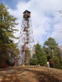
The 60' firetower was constructed by the Civilian Conservation Corps (CCC) in 1937.