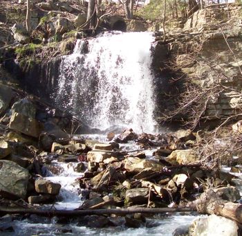
Dolan Branch Trail
| |||||||||||||||||||||||||||||||||||||
Trail Overview
Short walk around the base of Dolan Branch falls. Deer like to graze further down the trail in the forest along the creek.
How to get there
Follow directions to Bays Mountain Park. From parking lot, carefully walk along the left side of the park road or follow the short connector path by the chain-link fence to unmarked trailhead.
Route Description
Originally, this trail followed the cast iron water line (see photo gallery below) down the hill from the reservoir. While still shown on the park map as having a line to Eastman Recreation Area, that trail section has not been maintained or cleared from the 2009 winter storm damage, thus mostly impassible.
The 0.3 mile route shown on the map is down a few steps, cross the foot bridge, and peters out near the base of a former building. Return by backtracking up the hill. The main point of interest is the waterfall from the flow out of the dam, which is best after hard rains.
The original path along the water line and creek still goes some distance down to a valve house, although several very large blowdowns must be crossed.
Typical Conditions
The trail has bypassed to the side of the stone steps originally installed. The footbridge was replaced a few years ago, but warning - several boards on the main deck have already broken. As noted above, one path has few large blowdowns to climb over.
Regulations
Dogs are allowed on this trail. Bikes are not.
Misc. Information
Maps
<googlemap version="0.9" lat="36.497" lon="-82.483" type="terrain" zoom="15" width="400" height="350" scale="yes" controls="large" icons="http://tehcc.org/clubwiki/kml/marker{label}.png"> http://tehcc.org/clubwiki/kml/BMP_Dolan_Branch_Trail.kml (A) 36.49686,-82.48409 Trailhead by park campground entrance (L) 36.49587,-82.47730 Footbridge (J) 36.49529,-82.47646 [[Image:BMP Dolan Branch Trail waterfall.JPG|150px|Dolan Branch waterfall </googlemap>
Bays Mountain Hiking and Biking Trail Map link<
Photos
- Placeholder.gif
