Dolan Branch Trail: Difference between revisions
(update needs after kml addition and rezoom map) |
(convert to new trail form template) |
||
| Line 1: | Line 1: | ||
{{Trail | |||
|Banner Image= | |||
|Park=Bays Mountain Park | |||
|City=Kingsport | |||
|Land Owner=City of Kingsport | |||
|Trail Marking=Signs | |||
|Trail Use=Hiking, Geocaching | |||
|Trail Features=Lakes, Mountains | |||
|Difficulty Rating=Medium | |||
|Hike Time=1.5 hr | |||
|Trail Distance=2.316 mi | |||
|Round Trip Distance=2.316 mi | |||
|Trail Type=Loop | |||
|High Point=1,922 Ft | |||
|Low Point=1,826 ft | |||
|Elevation Gain=143 Ft | |||
|Elevation Loss=145 Ft | |||
|Elevation Change Direction=Counter Clockwise | |||
|Parking location=36.50882, -82.60955 | |||
|Trailhead location=36.50821,-82.61196 | |||
}} | |||
{{Trail Map}} | |||
__TOC__ | |||
== Trail Overview == | == Trail Overview == | ||
Located in [[Bays Mountain Park]]. Short walk around the base of Dolan Branch falls. Deer like to graze farther down the trail in the forest along the creek. | Located in [[Bays Mountain Park]]. Short walk around the base of Dolan Branch falls. Deer like to graze farther down the trail in the forest along the creek. | ||
| Line 72: | Line 54: | ||
In November, 2011, Dolan Branch Trail, the unmaintained path between Dolan Trail and Eastman Corporation's Forest Walk trail were hiked. Forest Walk trail is a well maintained 0.7 mile loop that starts and ends at the Eastman Recreation picnic area and goes upstream along one side of Dolan Branch and back down the opposite side to the start/end point. Benches and steps are well placed along the loop. Eastman Recreation land is private property for use by current or retired Eastman employees and guests. The friend I was with is a retired Eastman employee who signed us in at the Eastman entrance for the Forest Walk loop hike. | In November, 2011, Dolan Branch Trail, the unmaintained path between Dolan Trail and Eastman Corporation's Forest Walk trail were hiked. Forest Walk trail is a well maintained 0.7 mile loop that starts and ends at the Eastman Recreation picnic area and goes upstream along one side of Dolan Branch and back down the opposite side to the start/end point. Benches and steps are well placed along the loop. Eastman Recreation land is private property for use by current or retired Eastman employees and guests. The friend I was with is a retired Eastman employee who signed us in at the Eastman entrance for the Forest Walk loop hike. | ||
== Photos == | == Photos == | ||
{{Park trail gallery|Trail={{PAGENAME}}}} | |||
{{Map Marker|Icon Type=Trail sign|Marker Title=Trailhead|Marker Description= |Marker Location=36.50863,-82.61184}} | |||
{{Map Marker|Icon Type=Trail bridge|Marker Title=Footbridge|Marker Description=[[Image:BMP Dolan Branch Trail footbridge1.JPG|150px|Dolan Branch footbridge]]|Marker Location=36.50821,-82.61196}} | |||
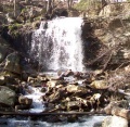
{{Map Marker|Icon Type=Waterfall|Marker Title=Footbridge|Marker Description=[[Image:BMP Dolan Branch Trail waterfall.JPG|150px|Dolan Branch waterfall]]|Marker Location=36.50838,-82.61194}} | |||
Image:BMP Dolan Branch Trail footbridge1.JPG|Dolan Branch footbridge | |||
Image:BMP Dolan Branch Trail | |||
Revision as of 07:37, 15 December 2019
| Dolan Branch Trail (log in to submit report) | |
|---|---|
| Park | Bays Mountain Park |
| Land Owner | City of Kingsport |
| Located | Kingsport, Tennessee |
| Trail Marking | Signs |
| Trail UseThings allowed to do on or near the trail |
|
| FeaturesThings to see on or near the trail |
|
| Difficulty Rating | Medium |
| Hiking TimeTime from car and back. Includes any time hiking to access this trail. | 1.5 hr0.0938 Days <br />90 Min <br /> round trip |
| Distance: | 2.316 mi3.727 km <br /> trailStrict non-repeating trail length / 2.316 mi3.727 km <br /> round tripTypical or shortest length from the car, hike the trail, and return to car |
| Trail Type | Loop |
| Low / High Point | 1,826 ft608.667 Yards <br />556.565 Meters <br /> / 1,922 Ft640.667 Yards <br />585.826 Meters <br /> |
| Elev. Gain/LossSee link for details of calculation. Gain/Loss is direction dependent. | 143 Ft43.586 Meters <br /> / (145 Ft44.196 Meters <br />) – Counter Clockwise |
| Trip ReportsFrom user "hiked it" submissions<br />Recent is within last 90 days | No hikes logged yet |
| NearbyWithin 5 mi<br />Click link to view list | 32 trails / 38.1 mi of trail |
| Parking | 36° 30' 31.75" N, 82° 36' 34.38" W Map |
| Trailhead | 36° 30' 29.56" N, 82° 36' 43.06" W Map |
|
| |
| Show In Google Maps | |
Download KML / Upload new version / KML File Page / Create Profile Chart / gpsvisualizer Map
Trail Overview
Located in Bays Mountain Park. Short walk around the base of Dolan Branch falls. Deer like to graze farther down the trail in the forest along the creek.
How to get there
Follow directions to Bays Mountain Park. From parking lot, carefully walk along the left side of the park road or follow the short connector path by the chain-link fence to unmarked trailhead.
Route Description
Originally, this trail followed the cast iron water line (see photo gallery below) down the hill from the reservoir. While still shown on the park map as having a line to Eastman Recreation Area, that trail section has not been maintained or cleared from the 2009 winter storm damage, thus mostly impassible.
The 0.3 mile route shown on the map is down a few steps, cross the foot bridge, and peters out near the base of a former building. Return by backtracking up the hill. The main point of interest is the waterfall from the flow out of the dam, which is best after hard rains.
The original path along the water line and creek still goes some distance down to a valve house, although several very large blowdowns must be crossed.
Typical Conditions
The trail has bypassed to the side of the stone steps originally installed. The footbridge was replaced a few years ago, but warning - several boards on the main deck have already broken. As noted above, one path has few large blowdowns to climb over.
Regulations
Dogs are allowed on this trail. Bikes are not.
Misc. Information
Joseph T. Wyrick published a book, copyright 1982, entitled "Hiking Trails in Bays Mountain Park" in which he described park trails in detail as they existed at the time of his book's publication. Book is in Nature Center library.
Dolan Trail was described in 1982 as a one-half mile loop trail which crossed Dolan Branch near the falls with a second crossing a short distance downstream for a return back upstream toward the dam. The concrete bridge abutments for both bridges could be seem in 2007 as could both sides of Dolan Trail loop as described by Mr. Wyrick. However both bridges were absent in 2007. The current upstream bridge was built in 2008.
A Bays Mountain Park 1982 trail map at the end of Mr.Wyrick's book showed Dolan Trail as a loop and the line down toward Eastman Recreation Center property was labeled Dolan Branch. As stated in the Route Description the waterfall is the main point of interest which the current map trail leads visitors to view. However, with a former Kingsport water supply pipeline along Dolan Branch and the general attraction of what is now Bays Mountain Park, a pathway became a natural means of access for many decades.
In November, 2011, Dolan Branch Trail, the unmaintained path between Dolan Trail and Eastman Corporation's Forest Walk trail were hiked. Forest Walk trail is a well maintained 0.7 mile loop that starts and ends at the Eastman Recreation picnic area and goes upstream along one side of Dolan Branch and back down the opposite side to the start/end point. Benches and steps are well placed along the loop. Eastman Recreation land is private property for use by current or retired Eastman employees and guests. The friend I was with is a retired Eastman employee who signed us in at the Eastman entrance for the Forest Walk loop hike.
Photos
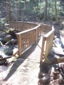
Dolan Branch footbridge
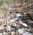
Dolan Branch runoff and footbridge viewed from near trailhead

Former water pipe for Kingsport reservoir

Trail Profile


