Doe River Gorge: Difference between revisions
(Fixed broken link to Doe River Gorge) |
m (Text replacement - "http://tehcc.org/clubwiki/" to "https://tehcc.org/clubwiki/") |
||
| (7 intermediate revisions by 4 users not shown) | |||
| Line 1: | Line 1: | ||
<!-- The following few lines create the "Infobox" table template. Please scroll down to edit the main content of the article. | <!-- The following few lines create the "Infobox" table template. Please scroll down to edit the main content of the article. | ||
<!-- | -->{{Infobox Trail | ||
| Image Name = Doe-River-2.jpg | |||
| Trail Number = | |||
| Park = | |||
| City = Hampton | |||
| State = Tennessee | |||
| Marking = None | |||
| Trail Use = {{Hike}} | |||
| Difficulty Rating = Easy | |||
| Hike Time = 3 hrs | |||
| Round Trip Distance = 5 mi | |||
| Trail Distance = 2.5 mi | |||
| Trail Type = In-and-Out | |||
| Elevation Gain = 230 | |||
| Elevation Loss = -230 | |||
| Low Point = | |||
| Elevation Change = | |||
| High Point = 2,255 ft | |||
| Parking coords = 36.2671,-82.1735 | |||
| Trailhead coords = 36.2671,-82.1735 | |||
| Medical = Elizabethton, TN | |||
}}<!-- | |||
End Infobox template table | |||
-->{{Trail page needs | |||
| Hide needs = | |||
| KML = | |||
| Updated KML = | |||
| Detail route description = | |||
| Photos = | |||
| Winter photos = | |||
| Remove prefix = | |||
| Update infobox = | |||
| Infobox data update = Yes | |||
| Trail pins = | |||
| Other = | |||
| Comment = | |||
| Date reviewed = 10/24/2015 | |||
}}<!-- | |||
Start of Main Page --> | |||
== Trail Overview == | == Trail Overview == | ||
Easy 5 mile round trip hike following an old railroad through two tunnels. Views of towering cliffs, stream, and forest. | Easy 5 mile round trip hike following an old railroad through two tunnels. Views of towering cliffs, stream, and forest. | ||
| Line 32: | Line 56: | ||
== Route Description== | == Route Description== | ||
The route is very simple - follow the railroad bed up to the former | The route is very simple - follow the railroad bed up to the former deck bridge and back. | ||
{| class="wikitable" border="1" | {| class="wikitable" border="1" | ||
| Line 55: | Line 79: | ||
|- | |- | ||
|2.5 | |2.5 | ||
|End of hiking trail at former | |End of hiking trail at former deck bridge - DO NOT ATTEMPT TO CROSS! | ||
|} | |} | ||
| Line 64: | Line 88: | ||
Permission to hike the trail must be obtained prior to the trip from [http://www.doerivergorge.com/index.php Doe River Gorge Ministries] Tel: (423) 725-4010 | Permission to hike the trail must be obtained prior to the trip from [http://www.doerivergorge.com/index.php Doe River Gorge Ministries] Tel: (423) 725-4010 | ||
<br>Each person (or family) will need to fill out and sign a [[Media:Doe_River_Gorge_Visitor_Registration_Form.pdf|visitor release form]], which is then dropped off in the train mail box at the front of the offices. | <br>Each person (or family) will need to fill out and sign a [[Media:Doe_River_Gorge_Visitor_Registration_Form.pdf|visitor release form]], which is then dropped off in the train mail box at the front of the offices. | ||
<br>This hiking trail is unavailable during the summer (no permissions will be given) because Doe River Gorge Ministries conducts summer camps there. For 2017, this means no public hiking permissions will be granted from mid-May to mid-August 2017. | |||
== After the Hike == | == After the Hike == | ||
| Line 80: | Line 105: | ||
<!-- You can place pictures, PDF's, links, or even create a Google map with your waypoints and place it here. --> | <!-- You can place pictures, PDF's, links, or even create a Google map with your waypoints and place it here. --> | ||
< | <display_map type="terrain" width="80%" height="350" gkml="https://tehcc.org/clubwiki/kml/Doe_River_Gorge.kml"> | ||
36.2671, -82.1735~Parking~ ~MarkerA.png | |||
36.26640,-82.17156~Trailhead~ ~MarkerG.png | |||
36.26509,-82.17119~Tunnel #1~[[Image:Doe River Gorge Tunnel1.JPG|150px]]~MarkerR.png | |||
36.2618,-82.1625~Tunnel #2~[[Image:Doe River Gorge Tunnel2.JPG|150px]]~MarkerR.png | |||
36.24886,-82.15183~End of trail at truss~[[Image:Doe_River_Gorge_truss.JPG|150px]]~MarkerG.png | |||
</display_map> | |||
[[File:Doe_River_Gorge_profile.JPG]] | [[File:Doe_River_Gorge_profile.JPG]] | ||
Latest revision as of 12:12, 7 January 2023
| |||||||||||||||||||||||||||||||||||||||||||

Trail Overview[edit]
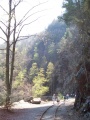
Easy 5 mile round trip hike following an old railroad through two tunnels. Views of towering cliffs, stream, and forest.
How to get there[edit]
From Kingsport, TN:
- Head south on I-26 to Exit 24 (Elizabethton).
- Proceed on US321 for eight miles into town.
- Turn right at traffic light to stay on US321 heading south.
- After six miles, enter driveway for Doe River Ministries. (Note: very small direction sign in highway median.)
- Park by the red caboose.
Trailhead is behind and between the sleeping cabooses and swimming area.
Route Description[edit]
The route is very simple - follow the railroad bed up to the former deck bridge and back.
| Distance | Doe River Gorge Trail |
|---|---|
| 0.0 mi | Trailhead by rail switch. |
| 0.1 | First tunnel. |
| 0.9 | Dirt spur trail heads left and downhill to lower zipline platform by river. Do not take per visitors' agreement. |
| 1.0 | Second tunnel. |
| 2.0 | Orange sign for end of trail travel. |
| 2.5 | End of hiking trail at former deck bridge - DO NOT ATTEMPT TO CROSS! |
Typical Conditions[edit]
Wide and settled gravel railroad bed with small changes in grade, thus easy path. The one side is a steep drop down to Doe River, thus small children will need to be watched.
Fees, Permits, etc.[edit]
Permission to hike the trail must be obtained prior to the trip from Doe River Gorge Ministries Tel: (423) 725-4010
Each person (or family) will need to fill out and sign a visitor release form, which is then dropped off in the train mail box at the front of the offices.
This hiking trail is unavailable during the summer (no permissions will be given) because Doe River Gorge Ministries conducts summer camps there. For 2017, this means no public hiking permissions will be granted from mid-May to mid-August 2017.
After the Hike[edit]
Elizabethton has several places to enjoy for dinner.
Misc. Information[edit]
Per their visitation policy:
NO SMOKING
NO PETS
NO MINORS ALONE
HIKING ON RAILROAD BED ONLY
NO THROWING ROCKS AT ANY TIME - which may be a challenge given the river runs right along the gravel railroad bed
Maps[edit]

Photos[edit]
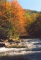
Trail follows Doe River
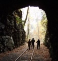
Walking thru one of two tunnels
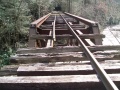
Trail ends here
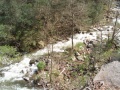
Looking into gorge
Walking along the rails
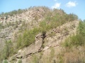
Cliffs along the gorge
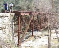
Side view of the truss


Wildflower Gallery - Peak time to visit might be early to middle May.


