Cross Ridges Trail: Difference between revisions
m (→Maps: corrected kml file name) |
(tweaks using form) |
||
| (17 intermediate revisions by 4 users not shown) | |||
| Line 1: | Line 1: | ||
{{Trail | |||
{{ | |Banner Image=File:BMP Bill Simpson cabin.JPG | ||
|Park=Bays Mountain Park | |||
|Land Owner=City of Kingsport | |||
|Trail Marking=Signs | |||
|Trail Use=Hiking, Biking, Geocaching | |||
|Trail Features=Lakes, Mountains | |||
|Difficulty Rating=Medium | |||
|Hike Time=45 min | |||
|Trail Distance=0.64 mi | |||
|Round Trip Distance=4.6 mi | |||
|Trail Type=Segment | |||
|High Point=1,834 Ft | |||
|Low Point=1,664 ft | |||
|Elevation Gain=132 Ft | |||
|Elevation Loss=100 Ft | |||
|Elevation Change Direction=West-to-East | |||
36. | |Parking location=36.50882, -82.60955 | ||
|Trailhead location=36.49777, -82.6427 | |||
}} | }} | ||
{{Trail Map|Other Trails=Front Hollow Road,Back Hollow Road,Cherry Knobs}} | |||
__TOC__ | |||
== Trail Overview == | == Trail Overview == | ||
Located in [[Bays Mountain Park]]. Trail between [[Front Hollow Road|Front Hollow Road]] and [[Back Hollow Road|Back Hollow Road]]. Lots of spring wildflowers on northern side in the shaded hollow. | |||
Located in [[Bays Mountain Park]]. | |||
== How to get there == | == How to get there == | ||
<!-- Please enter detailed instruction on how to find the trail head. --> | <!-- Please enter detailed instruction on how to find the trail head. --> | ||
The trail is not directly accessible from the main parking lot. Cross the dam and take either Follow [[ | The trail is not directly accessible from the main parking lot. Cross the dam and take either Follow [[Lake Road (Bays Mountain Park)|Lake Road]] to [[Front Hollow Road|Front Hollow Road]] until reaching trail sign or [[Lake Road (Bays Mountain Park)|Lake Road]] to Feagins Gap and onto [[Back Hollow Road|Back Hollow Road]] until old homestead is seen. | ||
== Route Description== | == Route Description== | ||
[[File:Cross ridges trail profile.png|thumb|right]] | |||
<!-- Detailed description of the route. Is there any side trails that are worth traveling? --> | <!-- Detailed description of the route. Is there any side trails that are worth traveling? --> | ||
A 0.7 mile connecting trail between the "Hollow" roads. | A 0.7 mile connecting trail between the "Hollow" roads. | ||
This trail has connections to [[Trail connects to::Back Hollow Road]], [[Trail connects to::Pretty Ridge Trail]], [[Trail connects to::Cherry Knobs]], and [[Trail connects to::Front Hollow Road]]. | |||
{| class="wikitable" border="1" | {| class="wikitable" border="1" | ||
| Line 41: | Line 41: | ||
!Cross Ridges Trail | !Cross Ridges Trail | ||
!Miles | !Miles | ||
!Elevation (ft) | |||
|- | |- | ||
|0.0 | |0.0 | ||
|Trailhead at [[ | |Trailhead at [[Front Hollow Road|Front Hollow Road]] | ||
|0.7 | |0.7 | ||
|1730 | |||
|- | |- | ||
|0.2 | |0.2 | ||
|Junction with [[ | |Junction with [[Cherry Knobs]] | ||
|0.5 | |0.5 | ||
|1840 | |||
|- | |- | ||
|0.65 | |0.65 | ||
|Creek crossing with no bridge | |Creek crossing with no bridge | ||
|0.05 | |0.05 | ||
| | |||
|- | |- | ||
|0.7 | |0.7 | ||
|Junction at [[ | |Junction at [[Back Hollow Road|Back Hollow Road]] and [[Pretty Ridge Trail|Pretty Ridge Trail]] at former "Bill Simpson" homestead | ||
|0.0 | |0.0 | ||
|1672 | |||
|} | |} | ||
Back Hollow Road continues towards Feagins Gap from right and behind the abandoned cabin. | Back Hollow Road continues towards Feagins Gap from right and behind the abandoned cabin. Pretty Ridge Trail has an unlabeled post, but heads uphill from left of the cabin. A fallen pine tree was partially covering this junction. | ||
== Typical Conditions == | == Typical Conditions == | ||
<!-- Typical conditions throughout the year of what to expect on the trail. Rocky, muddy, sandy, flowers, lots of downed trees? --> | <!-- Typical conditions throughout the year of what to expect on the trail. Rocky, muddy, sandy, flowers, lots of downed trees? --> | ||
Much lesser used trail. | Much lesser used trail. As of 2015, trail is cleaned up and most blowdowns removed. The two remaining are easy to step over. | ||
== Regulations == | == Regulations == | ||
NO BIKES! | NO BIKES! And too much trouble with all of the blowdowns anyway. | ||
== Misc. Information == | == Misc. Information == | ||
<!-- Enter any additional information that doesn't fit an any other fields. Any seasonal features, factoids, etc...? --> | <!-- Enter any additional information that doesn't fit an any other fields. Any seasonal features, factoids, etc...? --> | ||
Many spring wildflowers seen in April. Check out the below | Many spring wildflowers seen in April. Check out the gallery below. | ||
== Photos == | == Photos == | ||
{{Park trail gallery|Trail={{PAGENAME}}}} | |||
Wildflower Gallery - mid-April 2011 | Wildflower Gallery - mid-April 2011 | ||
| Line 106: | Line 85: | ||
Image:BMP Cross Ridges Trail Fire Pink.JPG|Fire Pink [http://uswildflowers.com/detail.php?SName=Silene%20virginica more info] | Image:BMP Cross Ridges Trail Fire Pink.JPG|Fire Pink [http://uswildflowers.com/detail.php?SName=Silene%20virginica more info] | ||
Image:BMP Cross Ridges Trail Yellow Leafcup.JPG|Yellow Leafcup [http://uswildflowers.com/detail.php?SName=Smallanthus%20uvedalius more info] | Image:BMP Cross Ridges Trail Yellow Leafcup.JPG|Yellow Leafcup [http://uswildflowers.com/detail.php?SName=Smallanthus%20uvedalius more info] | ||
Image:BMP Cross Ridges Trail star chickweed.JPG|Star Chickweed [http://patriot.net/~eweidaw/wildflower.htm more info] | |||
Image:BMP Cross Ridges Trail wild geranium.JPG|Wild Geranium [http://www.illinoiswildflowers.info/woodland/plants/wild_geranium.htm more info] | |||
Image:BMP Cross Ridges Trail Sweet White Violet.JPG|Sweet White Violet [http://uswildflowers.com/detail.php?SName=Viola%20blanda more info] | |||
</gallery> | </gallery> | ||
{{Map Marker | |||
|Icon Type=Trail sign | |||
|Marker Title=Junction with [[Back Hollow Road|Back Hollow Road]] | |||
[[ | |Marker Description=and [[Pretty Ridge Trail|Pretty Ridge Trail]] | ||
|Marker Location=36.49777,-82.64269 | |||
}} | |||
{{Map Marker | |||
|Icon Type=Trail sign | |||
|Marker Title=Junction with [[Cherry Knobs]] | |||
|Marker Description=[[Image:BMP CK-CR sign.JPG|50px]] | |||
|Marker Location=36.49683,-82.63629 | |||
}} | |||
{{Map Marker | |||
|Icon Type=Water crossing | |||
|Marker Title=Stream crossing - no bridge | |||
|Marker Description=[[Image:BMP Cross Ridges Trail stream crossing.JPG|150px]] | |||
|Marker Location=36.49770,-82.64250 | |||
}} | |||
{{Map Marker | |||
|Icon Type=Trail sign | |||
|Marker Title=Trailhead at [[Front Hollow Road|Front Hollow Road]] | |||
|Marker Description=[[Image:BMP CR FHR sign.JPG|50px]] | |||
|Marker Location=36.49511,-82.63438 | |||
}} | |||
Latest revision as of 23:11, 14 December 2019
| Cross Ridges Trail (log in to submit report) | |
|---|---|

| |
| Park | Bays Mountain Park |
| Land Owner | City of Kingsport |
| Located | Kingsport, TennesseeLocation inherited from associated park |
| Trail Marking | Signs |
| Trail UseThings allowed to do on or near the trail |
|
| FeaturesThings to see on or near the trail |
|
| Difficulty Rating | Medium |
| Hiking TimeTime from car and back. Includes any time hiking to access this trail. | 45 min0.75 Hours <br />0.0469 Days <br /> round trip |
| Distance: | 0.64 mi1.03 km <br /> trailStrict non-repeating trail length / 4.6 mi7.403 km <br /> round tripTypical or shortest length from the car, hike the trail, and return to car |
| Trail Type | Segment |
| Low / High Point | 1,664 ft554.667 Yards <br />507.187 Meters <br /> / 1,834 Ft611.333 Yards <br />559.003 Meters <br /> |
| Elev. Gain/LossSee link for details of calculation. Gain/Loss is direction dependent. | 132 Ft40.234 Meters <br /> / (100 Ft30.48 Meters <br />) – West-to-East |
| Trip ReportsFrom user "hiked it" submissions<br />Recent is within last 90 days | No hikes logged yet |
| NearbyWithin 5 mi<br />Click link to view list | 32 trails / 37.9 mi of trail |
| Parking | 36° 30' 31.75" N, 82° 36' 34.38" W Map |
| Trailhead | 36° 29' 51.97" N, 82° 38' 33.72" W Map |
|
| |
| Show In Google Maps | |
Download KML / Upload new version / KML File Page / Create Profile Chart / gpsvisualizer Map
Trail Overview[edit]
Located in Bays Mountain Park. Trail between Front Hollow Road and Back Hollow Road. Lots of spring wildflowers on northern side in the shaded hollow.
How to get there[edit]
The trail is not directly accessible from the main parking lot. Cross the dam and take either Follow Lake Road to Front Hollow Road until reaching trail sign or Lake Road to Feagins Gap and onto Back Hollow Road until old homestead is seen.
Route Description[edit]

A 0.7 mile connecting trail between the "Hollow" roads.
This trail has connections to Back Hollow Road, Pretty Ridge Trail, Cherry Knobs, and Front Hollow Road.
| Miles | Cross Ridges Trail | Miles | Elevation (ft) |
|---|---|---|---|
| 0.0 | Trailhead at Front Hollow Road | 0.7 | 1730 |
| 0.2 | Junction with Cherry Knobs | 0.5 | 1840 |
| 0.65 | Creek crossing with no bridge | 0.05 | |
| 0.7 | Junction at Back Hollow Road and Pretty Ridge Trail at former "Bill Simpson" homestead | 0.0 | 1672 |
Back Hollow Road continues towards Feagins Gap from right and behind the abandoned cabin. Pretty Ridge Trail has an unlabeled post, but heads uphill from left of the cabin. A fallen pine tree was partially covering this junction.
Typical Conditions[edit]
Much lesser used trail. As of 2015, trail is cleaned up and most blowdowns removed. The two remaining are easy to step over.
Regulations[edit]
NO BIKES! And too much trouble with all of the blowdowns anyway.
Misc. Information[edit]
Many spring wildflowers seen in April. Check out the gallery below.
Photos[edit]
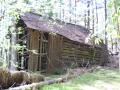
Trail ends just past "Bill Simpson" barn
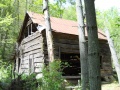
Bill Simpson Cabin

Trail Profile

Wildflower Gallery - mid-April 2011
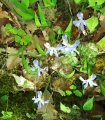
Dwarf Violet Iris more info
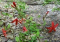
Fire Pink more info
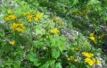
Yellow Leafcup more info
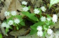
Star Chickweed more info
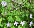
Wild Geranium more info
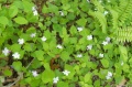
Sweet White Violet more info


