Loading map...
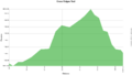
{"format":"googlemaps3","type":"TERRAIN","minzoom":false,"maxzoom":false,"types":["SATELLITE","HYBRID","TERRAIN"],"limit":50,"offset":0,"link":"none","sort":[""],"order":[],"headers":"show","mainlabel":"","intro":"","outro":"","searchlabel":"... further results","default":"","import-annotation":false,"width":"auto","height":"600px","centre":false,"title":"","label":"","icon":"","lines":[],"polygons":[],"circles":[],"rectangles":[],"copycoords":false,"static":false,"visitedicon":"","wmsoverlay":false,"zoom":false,"layers":[],"controls":["pan","zoom","type","scale","streetview","rotate"],"zoomstyle":"DEFAULT","typestyle":"DEFAULT","autoinfowindows":false,"resizable":false,"kmlrezoom":true,"poi":true,"cluster":false,"clustergridsize":60,"clustermaxzoom":20,"clusterzoomonclick":true,"clusteraveragecenter":true,"clusterminsize":2,"imageoverlays":[],"kml":[],"gkml":["https://tehcc.org/clubwiki/images/Back_Hollow_Road.kml","https://tehcc.org/clubwiki/images/Cherry_Knobs.kml","https://tehcc.org/clubwiki/images/Cross_Ridges_Trail.kml","https://tehcc.org/clubwiki/images/Front_Hollow_Road.kml"],"searchmarkers":"","fullscreen":false,"scrollwheelzoom":false,"showtitle":false,"hidenamespace":true,"template":"Map Balloon Template","userparam":"","activeicon":"","pagelabel":false,"ajaxcoordproperty":"","ajaxquery":"","locations":[{"text":"\u003Cp\u003E\u003Cb\u003E\u003Ca href=\"/wiki/Back_Hollow_Road\" title=\"Back Hollow Road\"\u003EBack Hollow Road\u003C/a\u003E\u003C/b\u003E\u003Cbr /\u003E\u003C/p\u003E\u003Chr /\u003E\u003Cp\u003E1.94\u0026#160;Mi (3.13\u0026#160;km)\u003Cbr /\u003EDifficulty: Easy\u003Cbr /\u003EMarking: Signs\u003C/p\u003E","title":"Back Hollow Road","link":"","lat":36.506540000000001100488589145243167877197265625,"lon":-82.631270000000000663931132294237613677978515625,"icon":"/clubwiki/images/MarkerT.png"},{"text":"\u003Cp\u003E\u003Cb\u003EIntersection at \u003Ca href=\"/wiki/BMP_Pretty_Ridge_Trail\" class=\"mw-redirect\" title=\"BMP Pretty Ridge Trail\"\u003EPretty Ridge Trail\u003C/a\u003E\u003C/b\u003E\u003Cbr /\u003E\u003C/p\u003E\u003Chr /\u003E\u003Cp\u003EIntersection at \u003Ca href=\"/wiki/BMP_Pretty_Ridge_Trail\" class=\"mw-redirect\" title=\"BMP Pretty Ridge Trail\"\u003EPretty Ridge Trail\u003C/a\u003E\u003C/p\u003E","title":"Back Hollow Road","link":"","lat":36.49759999999999848796505830250680446624755859375,"lon":-82.6432999999999964302332955412566661834716796875,"icon":"/clubwiki/images/MarkerT.png"},{"text":"\u003Cp\u003E\u003Cb\u003EPark primitive cabin\u003C/b\u003E\u003Cbr /\u003E\u003C/p\u003E\u003Chr /\u003E\u003Cp\u003E\u003Ca href=\"/wiki/File:BMP_cabin.JPG\" class=\"image\"\u003E\u003Cimg alt=\"BMP cabin.JPG\" src=\"/clubwiki/images/thumb/BMP_cabin.JPG/150px-BMP_cabin.JPG\" decoding=\"async\" width=\"150\" height=\"113\" srcset=\"/clubwiki/images/thumb/BMP_cabin.JPG/225px-BMP_cabin.JPG 1.5x, /clubwiki/images/thumb/BMP_cabin.JPG/300px-BMP_cabin.JPG 2x\" data-file-width=\"448\" data-file-height=\"336\" /\u003E\u003C/a\u003E\u003C/p\u003E","title":"Back Hollow Road","link":"","lat":36.50095999999999918372850515879690647125244140625,"lon":-82.638599999999996725819073617458343505859375,"icon":"/clubwiki/images/MarkerV.png"},{"text":"\u003Cp\u003E\u003Cb\u003EFeagins Gap\u003C/b\u003E\u003Cbr /\u003E\u003C/p\u003E\u003Chr /\u003E\u003Cp\u003EFeagins Gap\u003C/p\u003E","title":"Back Hollow Road","link":"","lat":36.50654800000000221871232497505843639373779296875,"lon":-82.6312779999999946767275105230510234832763671875,"icon":"/clubwiki/images/MarkerT.png"},{"text":"\u003Cp\u003E\u003Cb\u003ELog bridge to Primitive Campground\u003C/b\u003E\u003Cbr /\u003E\u003C/p\u003E\u003Chr /\u003E\u003Cp\u003E\u003Ca href=\"/wiki/File:BMP_Primative_Campground.JPG\" class=\"image\"\u003E\u003Cimg alt=\"BMP Primative Campground.JPG\" src=\"/clubwiki/images/thumb/BMP_Primative_Campground.JPG/150px-BMP_Primative_Campground.JPG\" decoding=\"async\" width=\"150\" height=\"113\" srcset=\"/clubwiki/images/thumb/BMP_Primative_Campground.JPG/225px-BMP_Primative_Campground.JPG 1.5x, /clubwiki/images/thumb/BMP_Primative_Campground.JPG/300px-BMP_Primative_Campground.JPG 2x\" data-file-width=\"448\" data-file-height=\"336\" /\u003E\u003C/a\u003E\u003C/p\u003E","title":"Back Hollow Road","link":"","lat":36.5004899999999992132870829664170742034912109375,"lon":-82.6393599999999963756636134348809719085693359375,"icon":"/clubwiki/images/MarkerH.png"},{"text":"\u003Cp\u003E\u003Cb\u003E\u003Ca href=\"/wiki/Cherry_Knobs\" title=\"Cherry Knobs\"\u003ECherry Knobs\u003C/a\u003E\u003C/b\u003E\u003Cbr /\u003E\u003C/p\u003E\u003Chr /\u003E\u003Cp\u003E1.53\u0026#160;Mi (2.46\u0026#160;km)\u003Cbr /\u003EDifficulty: Medium\u003Cbr /\u003EMarking: Signs\u003C/p\u003E","title":"Cherry Knobs","link":"","lat":36.5057680000000033260221243835985660552978515625,"lon":-82.6181980000000066866050474345684051513671875,"icon":"/clubwiki/images/MarkerT.png"},{"text":"\u003Cp\u003E\u003Cb\u003EJunction with \u003Ca class=\"mw-selflink selflink\"\u003ECross Ridges Trail\u003C/a\u003E\u003C/b\u003E\u003Cbr /\u003E\u003C/p\u003E\u003Chr /\u003E\u003Cp\u003E\u003Ca href=\"/wiki/File:BMP_CK-CR_sign.JPG\" class=\"image\"\u003E\u003Cimg alt=\"BMP CK-CR sign.JPG\" src=\"/clubwiki/images/thumb/BMP_CK-CR_sign.JPG/50px-BMP_CK-CR_sign.JPG\" decoding=\"async\" width=\"50\" height=\"142\" srcset=\"/clubwiki/images/thumb/BMP_CK-CR_sign.JPG/75px-BMP_CK-CR_sign.JPG 1.5x, /clubwiki/images/thumb/BMP_CK-CR_sign.JPG/100px-BMP_CK-CR_sign.JPG 2x\" data-file-width=\"158\" data-file-height=\"448\" /\u003E\u003C/a\u003E\u003C/p\u003E","title":"Cherry Knobs","link":"","lat":36.4968300000000027694113668985664844512939453125,"lon":-82.636290000000002464730641804635524749755859375,"icon":"/clubwiki/images/MarkerT.png"},{"text":"\u003Cp\u003E\u003Cb\u003EHalf dozen headstones around a small clearing\u003C/b\u003E\u003Cbr /\u003E\u003C/p\u003E\u003Chr /\u003E\u003Cp\u003EHalf dozen headstones around a small clearing\u003C/p\u003E","title":"Cherry Knobs","link":"","lat":36.504829999999998335624695755541324615478515625,"lon":-82.6185799999999943565853754989802837371826171875,"icon":"/clubwiki/images/MarkerN.png"},{"text":"\u003Cp\u003E\u003Cb\u003ESpur trail to cemetery\u003C/b\u003E\u003Cbr /\u003E\u003C/p\u003E\u003Chr /\u003E\u003Cp\u003ESpur trail to cemetery\u003C/p\u003E","title":"Cherry Knobs","link":"","lat":36.50544000000000011141310096718370914459228515625,"lon":-82.6189700000000044610715121962130069732666015625,"icon":"/clubwiki/images/MarkerT.png"},{"text":"\u003Cp\u003E\u003Cb\u003EJunction with \u003Ca href=\"/wiki/Lakeside_Trail\" title=\"Lakeside Trail\"\u003ELakeside Trail\u003C/a\u003E\u003C/b\u003E\u003Cbr /\u003E\u003C/p\u003E\u003Chr /\u003E\u003Cp\u003EJunction with \u003Ca href=\"/wiki/Lakeside_Trail\" title=\"Lakeside Trail\"\u003ELakeside Trail\u003C/a\u003E\u003C/p\u003E","title":"Cherry Knobs","link":"","lat":36.50583999999999917918103164993226528167724609375,"lon":-82.618300000000004956746124662458896636962890625,"icon":"/clubwiki/images/MarkerT.png"},{"text":"\u003Cp\u003E\u003Cb\u003EJunction with \u003Ca href=\"/wiki/Lake_Road_(Bays_Mountain_Park)\" title=\"Lake Road (Bays Mountain Park)\"\u003ELake Road\u003C/a\u003E\u003C/b\u003E\u003Cbr /\u003E\u003C/p\u003E\u003Chr /\u003E\u003Cp\u003E\u003Ca href=\"/wiki/File:BMP_CK_LR_sign1.JPG\" class=\"image\"\u003E\u003Cimg alt=\"BMP CK LR sign1.JPG\" src=\"/clubwiki/images/thumb/BMP_CK_LR_sign1.JPG/50px-BMP_CK_LR_sign1.JPG\" decoding=\"async\" width=\"50\" height=\"154\" srcset=\"/clubwiki/images/thumb/BMP_CK_LR_sign1.JPG/75px-BMP_CK_LR_sign1.JPG 1.5x, /clubwiki/images/thumb/BMP_CK_LR_sign1.JPG/100px-BMP_CK_LR_sign1.JPG 2x\" data-file-width=\"145\" data-file-height=\"448\" /\u003E\u003C/a\u003E\u003C/p\u003E","title":"Cherry Knobs","link":"","lat":36.50341999999999842430042917840182781219482421875,"lon":-82.6284699999999929787009023129940032958984375,"icon":"/clubwiki/images/MarkerT.png"},{"text":"\u003Cp\u003E\u003Cb\u003EJunction with \u003Ca href=\"/wiki/Lake_Road_(Bays_Mountain_Park)\" title=\"Lake Road (Bays Mountain Park)\"\u003ELake Road\u003C/a\u003E\u003C/b\u003E\u003Cbr /\u003E\u003C/p\u003E\u003Chr /\u003E\u003Cp\u003E\u003Ca href=\"/wiki/File:BMP_CK_LR_sign2.JPG\" class=\"image\"\u003E\u003Cimg alt=\"BMP CK LR sign2.JPG\" src=\"/clubwiki/images/thumb/BMP_CK_LR_sign2.JPG/50px-BMP_CK_LR_sign2.JPG\" decoding=\"async\" width=\"50\" height=\"156\" srcset=\"/clubwiki/images/thumb/BMP_CK_LR_sign2.JPG/75px-BMP_CK_LR_sign2.JPG 1.5x, /clubwiki/images/thumb/BMP_CK_LR_sign2.JPG/100px-BMP_CK_LR_sign2.JPG 2x\" data-file-width=\"144\" data-file-height=\"448\" /\u003E\u003C/a\u003E\u003C/p\u003E","title":"Cherry Knobs","link":"","lat":36.50097199999999730835043010301887989044189453125,"lon":-82.6309739999999948167896945960819721221923828125,"icon":"/clubwiki/images/MarkerT.png"},{"text":"\u003Cp\u003E\u003Cb\u003E\u003Ca class=\"mw-selflink selflink\"\u003ECross Ridges Trail\u003C/a\u003E\u003C/b\u003E\u003Cbr /\u003E\u003C/p\u003E\u003Chr /\u003E\u003Cp\u003E0.64\u0026#160;Mi (1.03\u0026#160;km)\u003Cbr /\u003EDifficulty: Medium\u003Cbr /\u003EMarking: Signs\u003C/p\u003E","title":"Cross Ridges Trail","link":"","lat":36.49777000000000271029421128332614898681640625,"lon":-82.6427000000000049340087571181356906890869140625,"icon":"/clubwiki/images/MarkerT.png"},{"text":"\u003Cp\u003E\u003Cb\u003EJunction with \u003Ca href=\"/wiki/Cherry_Knobs\" title=\"Cherry Knobs\"\u003ECherry Knobs\u003C/a\u003E\u003C/b\u003E\u003Cbr /\u003E\u003C/p\u003E\u003Chr /\u003E\u003Cp\u003E\u003Ca href=\"/wiki/File:BMP_CK-CR_sign.JPG\" class=\"image\"\u003E\u003Cimg alt=\"BMP CK-CR sign.JPG\" src=\"/clubwiki/images/thumb/BMP_CK-CR_sign.JPG/50px-BMP_CK-CR_sign.JPG\" decoding=\"async\" width=\"50\" height=\"142\" srcset=\"/clubwiki/images/thumb/BMP_CK-CR_sign.JPG/75px-BMP_CK-CR_sign.JPG 1.5x, /clubwiki/images/thumb/BMP_CK-CR_sign.JPG/100px-BMP_CK-CR_sign.JPG 2x\" data-file-width=\"158\" data-file-height=\"448\" /\u003E\u003C/a\u003E\u003C/p\u003E","title":"Cross Ridges Trail","link":"","lat":36.4968300000000027694113668985664844512939453125,"lon":-82.636290000000002464730641804635524749755859375,"icon":"/clubwiki/images/MarkerT.png"},{"text":"\u003Cp\u003E\u003Cb\u003EJunction with \u003Ca href=\"/wiki/Back_Hollow_Road\" title=\"Back Hollow Road\"\u003EBack Hollow Road\u003C/a\u003E\u003C/b\u003E\u003Cbr /\u003E\u003C/p\u003E\u003Chr /\u003E\u003Cp\u003Eand \u003Ca href=\"/wiki/Pretty_Ridge_Trail\" title=\"Pretty Ridge Trail\"\u003EPretty Ridge Trail\u003C/a\u003E\u003C/p\u003E","title":"Cross Ridges Trail","link":"","lat":36.49777000000000271029421128332614898681640625,"lon":-82.6426900000000017598722479306161403656005859375,"icon":"/clubwiki/images/MarkerT.png"},{"text":"\u003Cp\u003E\u003Cb\u003ETrailhead at \u003Ca href=\"/wiki/Front_Hollow_Road\" title=\"Front Hollow Road\"\u003EFront Hollow Road\u003C/a\u003E\u003C/b\u003E\u003Cbr /\u003E\u003C/p\u003E\u003Chr /\u003E\u003Cp\u003E\u003Ca href=\"/wiki/File:BMP_CR_FHR_sign.JPG\" class=\"image\"\u003E\u003Cimg alt=\"BMP CR FHR sign.JPG\" src=\"/clubwiki/images/thumb/BMP_CR_FHR_sign.JPG/50px-BMP_CR_FHR_sign.JPG\" decoding=\"async\" width=\"50\" height=\"209\" srcset=\"/clubwiki/images/thumb/BMP_CR_FHR_sign.JPG/75px-BMP_CR_FHR_sign.JPG 1.5x, /clubwiki/images/thumb/BMP_CR_FHR_sign.JPG/100px-BMP_CR_FHR_sign.JPG 2x\" data-file-width=\"107\" data-file-height=\"448\" /\u003E\u003C/a\u003E\u003C/p\u003E","title":"Cross Ridges Trail","link":"","lat":36.4951099999999968304109643213450908660888671875,"lon":-82.634379999999993060555425472557544708251953125,"icon":"/clubwiki/images/MarkerT.png"},{"text":"\u003Cp\u003E\u003Cb\u003EStream crossing - no bridge\u003C/b\u003E\u003Cbr /\u003E\u003C/p\u003E\u003Chr /\u003E\u003Cp\u003E\u003Ca href=\"/wiki/File:BMP_Cross_Ridges_Trail_stream_crossing.JPG\" class=\"image\"\u003E\u003Cimg alt=\"BMP Cross Ridges Trail stream crossing.JPG\" src=\"/clubwiki/images/thumb/BMP_Cross_Ridges_Trail_stream_crossing.JPG/150px-BMP_Cross_Ridges_Trail_stream_crossing.JPG\" decoding=\"async\" width=\"150\" height=\"200\" srcset=\"/clubwiki/images/thumb/BMP_Cross_Ridges_Trail_stream_crossing.JPG/225px-BMP_Cross_Ridges_Trail_stream_crossing.JPG 1.5x, /clubwiki/images/thumb/BMP_Cross_Ridges_Trail_stream_crossing.JPG/300px-BMP_Cross_Ridges_Trail_stream_crossing.JPG 2x\" data-file-width=\"768\" data-file-height=\"1024\" /\u003E\u003C/a\u003E\u003C/p\u003E","title":"Cross Ridges Trail","link":"","lat":36.49770000000000180762071977369487285614013671875,"lon":-82.6424999999999982946974341757595539093017578125,"icon":"/clubwiki/images/MarkerJ.png"},{"text":"\u003Cp\u003E\u003Cb\u003E\u003Ca href=\"/wiki/Front_Hollow_Road\" title=\"Front Hollow Road\"\u003EFront Hollow Road\u003C/a\u003E\u003C/b\u003E\u003Cbr /\u003E\u003C/p\u003E\u003Chr /\u003E\u003Cp\u003E1.70\u0026#160;Mi (2.74\u0026#160;km)\u003Cbr /\u003EDifficulty: Medium\u003Cbr /\u003EMarking: Signs\u003C/p\u003E","title":"Front Hollow Road","link":"","lat":36.4978100000000011959855328314006328582763671875,"lon":-82.6276500000000027057467377744615077972412109375,"icon":"/clubwiki/images/MarkerT.png"}]}
The trail is not directly accessible from the main parking lot. Cross the dam and take either Follow Lake Road to Front Hollow Road until reaching trail sign or Lake Road to Feagins Gap and onto Back Hollow Road until old homestead is seen.
A 0.7 mile connecting trail between the "Hollow" roads.
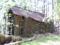
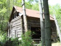
Back Hollow Road continues towards Feagins Gap from right and behind the abandoned cabin. Pretty Ridge Trail has an unlabeled post, but heads uphill from left of the cabin. A fallen pine tree was partially covering this junction.
Much lesser used trail. As of 2015, trail is cleaned up and most blowdowns removed. The two remaining are easy to step over.
NO BIKES! And too much trouble with all of the blowdowns anyway.
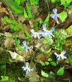
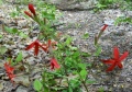
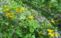
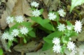
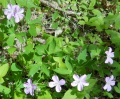
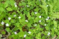
Many spring wildflowers seen in April. Check out the gallery below.