Connector: Difference between revisions
m (→Photos) |
m (→Photos: Learned the JPG extension is case-sensitive) |
||
| Line 66: | Line 66: | ||
<!-- Place any pictures from this trail below. Ideally we would have a picture of the trailhead to help people know when they found it --> | <!-- Place any pictures from this trail below. Ideally we would have a picture of the trailhead to help people know when they found it --> | ||
<!-- Add a picture by typing Image:imagename.extension --> | <!-- Add a picture by typing Image:imagename.extension --> | ||
Image:WPSP Connector Trail fishing spot view. | Image:WPSP Connector Trail fishing spot view.JPG|View from nice fishing spot | ||
Image:WPSP Connector Trail - Girls Inc bench. | Image:WPSP Connector Trail - Girls Inc bench.JPG|"Built by Girl Power" bench - Girls Inc | ||
Image:WPSP Connector Trail - wooden bridges.JPG|Pair of back-to-back trail bridges | Image:WPSP Connector Trail - wooden bridges.JPG|Pair of back-to-back trail bridges | ||
<!-- Do not remove the end gallery code.--> | <!-- Do not remove the end gallery code.--> | ||
Revision as of 06:07, 27 March 2011
| |||||||||||||||||||||||||||||||||||||

Trail Overview
Located in Warriors Path State Park. Short path along the shore of Ft. Patrick Henry Lake connecting WPSP Lakeshore Trail and WPSP Lake Hollow Trail, so that you can walk a loop around the park campground.
How to get there
Directions to main entrance found on Warriors Path State Park webpage. No direct trailhead. Reached by hiking either WPSP Lakeshore Trail and WPSP Lake Hollow Trail.
Route Description
Path proceeds around the east penisula along the shoreline below the main park campground. There are no trail blazes or trail signs, but the route is clear.
Typical Conditions
Well worn path with detours as the trees fall and shoreline crumbles into the lake. The park has installed RR ties as steps.
Fees, Permits, etc.
No fee required.
After the Hike
Misc. Information
Maps
<googlemap version="0.9" lat="36.4952" lon="-82.481" type="terrain" zoom="15" width="400" height="350" scale="yes" controls="large" icons="http://tehcc.org/clubwiki/kml/marker{label}.png"> http://tehcc.org/clubwiki/kml/WPSP_Connector_Trail.kml 36.49741,-82.47764 (A) Intersection Lakeshore and Connector Trails 36.49529,-82.47646 (A) Intersection Lake Hollow and Connector Trails </googlemap>
State Park Map and Trail Brochure
Photos
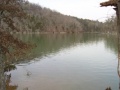
View from nice fishing spot
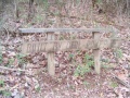
"Built by Girl Power" bench - Girls Inc
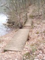
Pair of back-to-back trail bridges


