Cliffside Trail
| |||||||||||||||||||||||||||||||||||||

Trail Overview
Located in Bays Mountain Park. Up and along the ridgeline to a lookout tower.
How to get there
From the main parking lot, head over to the observatory. The unmarked trail heads uphill from here. Alternatively, head up Bays Mountain Road to observation tower and take the trail back down.
Route Description
Short steep hike along the ridgeline with couple of lookout points and up to the observation tower.
| Miles | Cliffside Trail | Miles |
|---|---|---|
| 0.0 | Trailhead at Astronomical Observatory (by "Sun" on solar model"). Also first overlook nearby. | 0.5 |
| 0.1 | Overlook near gate on Bays Mountain Road | 0.4 |
| 0.2 | Trail split. Up stairs is older route. Ahead is newer sidetrail alternative shown on park map. | 0.3 |
| 0.4 | Trail split on ridgeline. Down is newer sidetrail alternative shown on park map, while follow ridge to older route. | 0.1 |
| 0.5 | Observation Tower/Junction with Bays Mountain Road | 0.0 |
Typical Conditions
The older trail route is very worn and washed out on steep ascent with stone steps built long ago. Pine needle covered path once up on ridgeline. Alternate route is newer sidehill trail in excellent condition.
Regulations
NO BIKES!
Misc. Information
Selective removal of some trees around the lookout tower would greatly improve viewing year around.
Maps
<googlemap version="0.9" lat="36.50818" lon="-82.61083" type="terrain" zoom="15" width="775" scale="yes" icons="http://tehcc.org/clubwiki/kml/marker{label}.png"> http://tehcc.org/clubwiki/kml/BMP_Cliffside_Trail.kml http://tehcc.org/clubwiki/kml/BMP_bays_mountain_road.kml
(G) 36.50816,-82.61087
Trailhead near observatory at "Sun"
 (G) 36.50856,-82.60453
Trailhead at Bays Mountain Road
(G) 36.50657,-82.60898
Trail splits for old steps and alternative route
(E) 36.50845,-82.60445
Observation tower
(G) 36.50856,-82.60453
Trailhead at Bays Mountain Road
(G) 36.50657,-82.60898
Trail splits for old steps and alternative route
(E) 36.50845,-82.60445
Observation tower
 (E) 36.50788,-82.61073
View from lower overlook by observatory
(E) 36.50788,-82.61073
View from lower overlook by observatory
 (E) 36.50673,-82.60985
View from higher overlook along trail
(E) 36.50673,-82.60985
View from higher overlook along trail
 </googlemap>
- The following elevation profile travels from by the observatory up the main trail on the stairs and back down the alternate path.

Photos
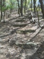
Older steps up Cliffside Trail
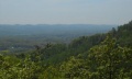
View from higher overlook along trail
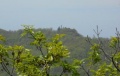
View from observation tower towards firetower
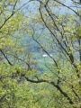
View from obs tower towards valley

