Loading map...
{"format":"googlemaps3","type":"TERRAIN","minzoom":false,"maxzoom":false,"types":["SATELLITE","HYBRID","TERRAIN"],"limit":50,"offset":0,"link":"none","sort":[""],"order":[],"headers":"show","mainlabel":"","intro":"","outro":"","searchlabel":"... further results","default":"","import-annotation":false,"width":"auto","height":"600px","centre":false,"title":"","label":"","icon":"","lines":[],"polygons":[],"circles":[],"rectangles":[],"copycoords":false,"static":false,"visitedicon":"","wmsoverlay":false,"zoom":false,"layers":[],"controls":["pan","zoom","type","scale","streetview","rotate"],"zoomstyle":"DEFAULT","typestyle":"DEFAULT","autoinfowindows":false,"resizable":false,"kmlrezoom":true,"poi":true,"cluster":false,"clustergridsize":60,"clustermaxzoom":20,"clusterzoomonclick":true,"clusteraveragecenter":true,"clusterminsize":2,"imageoverlays":[],"kml":[],"gkml":["https://tehcc.org/clubwiki/images/Azalea.kml","https://tehcc.org/clubwiki/images/Bays_Mountain_Road.kml","https://tehcc.org/clubwiki/images/Big_Oak_Trail.kml","https://tehcc.org/clubwiki/images/Chestnut_Trail.kml","https://tehcc.org/clubwiki/images/Lake_Road_(Bays_Mountain_Park).kml"],"searchmarkers":"","fullscreen":false,"scrollwheelzoom":false,"showtitle":false,"hidenamespace":true,"template":"Map Balloon Template","userparam":"","activeicon":"","pagelabel":false,"ajaxcoordproperty":"","ajaxquery":"","locations":[{"text":"\u003Cp\u003E\u003Cb\u003E\u003Ca href=\"/wiki/Azalea\" title=\"Azalea\"\u003EAzalea\u003C/a\u003E\u003C/b\u003E\u003Cbr /\u003E\u003C/p\u003E\u003Chr /\u003E\u003Cp\u003E1.37\u0026#160;Mi (2.21\u0026#160;km)\u003Cbr /\u003EDifficulty: Hard\u003Cbr /\u003EMarking: Signs\u003C/p\u003E","title":"Azalea","link":"","lat":36.51263000000000147338141687214374542236328125,"lon":-82.60511999999999943611328490078449249267578125,"icon":"/clubwiki/images/MarkerT.png"},{"text":"\u003Cp\u003E\u003Cb\u003EIntersection at \u003Ca href=\"/wiki/Big_Oak_Trail\" title=\"Big Oak Trail\"\u003EBig Oak Trail\u003C/a\u003E\u003C/b\u003E\u003Cbr /\u003E\u003C/p\u003E\u003Chr /\u003E\u003Cp\u003E\u003Ca href=\"/wiki/File:BMP_Split_at_Azalea_and_Big_Oak_Trails.JPG\" class=\"image\"\u003E\u003Cimg alt=\"BMP Split at Azalea and Big Oak Trails.JPG\" src=\"/clubwiki/images/thumb/BMP_Split_at_Azalea_and_Big_Oak_Trails.JPG/100px-BMP_Split_at_Azalea_and_Big_Oak_Trails.JPG\" decoding=\"async\" width=\"100\" height=\"75\" srcset=\"/clubwiki/images/thumb/BMP_Split_at_Azalea_and_Big_Oak_Trails.JPG/150px-BMP_Split_at_Azalea_and_Big_Oak_Trails.JPG 1.5x, /clubwiki/images/thumb/BMP_Split_at_Azalea_and_Big_Oak_Trails.JPG/200px-BMP_Split_at_Azalea_and_Big_Oak_Trails.JPG 2x\" data-file-width=\"448\" data-file-height=\"336\" /\u003E\u003C/a\u003E\u003C/p\u003E","title":"Azalea","link":"","lat":36.522210000000001173248165287077426910400390625,"lon":-82.5928300000000064073901739902794361114501953125,"icon":"/clubwiki/images/MarkerG.png"},{"text":"\u003Cp\u003E\u003Cb\u003ETrailhead at \u003Ca href=\"/wiki/Bays_Mountain_Road\" title=\"Bays Mountain Road\"\u003EBays Mountain Road\u003C/a\u003E\u003C/b\u003E\u003Cbr /\u003E\u003C/p\u003E\u003Chr /\u003E\u003Cp\u003E\u003Ca href=\"/wiki/File:BMP_Azalea_Trail_sign_at_BMR.JPG\" class=\"image\"\u003E\u003Cimg alt=\"BMP Azalea Trail sign at BMR.JPG\" src=\"/clubwiki/images/thumb/BMP_Azalea_Trail_sign_at_BMR.JPG/50px-BMP_Azalea_Trail_sign_at_BMR.JPG\" decoding=\"async\" width=\"50\" height=\"174\" srcset=\"/clubwiki/images/thumb/BMP_Azalea_Trail_sign_at_BMR.JPG/75px-BMP_Azalea_Trail_sign_at_BMR.JPG 1.5x, /clubwiki/images/thumb/BMP_Azalea_Trail_sign_at_BMR.JPG/100px-BMP_Azalea_Trail_sign_at_BMR.JPG 2x\" data-file-width=\"129\" data-file-height=\"448\" /\u003E\u003C/a\u003E\u003C/p\u003E","title":"Azalea","link":"","lat":36.52613999999999805368133820593357086181640625,"lon":-82.5877200000000044610715121962130069732666015625,"icon":"/clubwiki/images/MarkerG.png"},{"text":"\u003Cp\u003E\u003Cb\u003ETrailhead at \u003Ca href=\"/wiki/Lake_Road\" title=\"Lake Road\"\u003ELake Road\u003C/a\u003E\u003C/b\u003E\u003Cbr /\u003E\u003C/p\u003E\u003Chr /\u003E\u003Cp\u003E\u003Ca href=\"/wiki/File:BMP_Azalea_Trail_sign.JPG\" class=\"image\"\u003E\u003Cimg alt=\"BMP Azalea Trail sign.JPG\" src=\"/clubwiki/images/thumb/BMP_Azalea_Trail_sign.JPG/50px-BMP_Azalea_Trail_sign.JPG\" decoding=\"async\" width=\"50\" height=\"160\" srcset=\"/clubwiki/images/thumb/BMP_Azalea_Trail_sign.JPG/75px-BMP_Azalea_Trail_sign.JPG 1.5x, /clubwiki/images/thumb/BMP_Azalea_Trail_sign.JPG/100px-BMP_Azalea_Trail_sign.JPG 2x\" data-file-width=\"140\" data-file-height=\"448\" /\u003E\u003C/a\u003E\u003C/p\u003E","title":"Azalea","link":"","lat":36.512619999999998299244907684624195098876953125,"lon":-82.605199999999996407495927996933460235595703125,"icon":"/clubwiki/images/MarkerG.png"},{"text":"\u003Cp\u003E\u003Cb\u003E\u003Ca href=\"/wiki/Bays_Mountain_Road\" title=\"Bays Mountain Road\"\u003EBays Mountain Road\u003C/a\u003E\u003C/b\u003E\u003Cbr /\u003E\u003C/p\u003E\u003Chr /\u003E\u003Cp\u003E2.08\u0026#160;Mi (3.35\u0026#160;km)\u003Cbr /\u003EDifficulty: Medium\u003Cbr /\u003EMarking: Signs\u003C/p\u003E","title":"Bays Mountain Road","link":"","lat":36.50854000000000354475560015998780727386474609375,"lon":-82.6111700000000013233147910796105861663818359375,"icon":"/clubwiki/images/MarkerT.png"},{"text":"\u003Cp\u003E\u003Cb\u003EIntersection\u003C/b\u003E\u003Cbr /\u003E\u003C/p\u003E\u003Chr /\u003E\u003Cp\u003E\u003Ca href=\"/wiki/Azalea\" title=\"Azalea\"\u003EAzalea\u003C/a\u003E\u003C/p\u003E","title":"Bays Mountain Road","link":"","lat":36.52615999999999729652699897997081279754638671875,"lon":-82.5877799999999950841811369173228740692138671875,"icon":"/clubwiki/images/MarkerG.png"},{"text":"\u003Cp\u003E\u003Cb\u003EOverlook platform\u003C/b\u003E\u003Cbr /\u003E\u003C/p\u003E\u003Chr /\u003E\u003Cp\u003EOverlook platform\u003C/p\u003E","title":"Bays Mountain Road","link":"","lat":36.52300000000000324007487506605684757232666015625,"lon":-82.5900100000000065847416408360004425048828125,"icon":"/clubwiki/images/MarkerE.png"},{"text":"\u003Cp\u003E\u003Cb\u003ELocked gate on Bays Mountain Road\u003C/b\u003E\u003Cbr /\u003E\u003C/p\u003E\u003Chr /\u003E\u003Cp\u003E\u003Ca href=\"/wiki/File:BMP_Bays_Mountain_Road_gate.JPG\" class=\"image\"\u003E\u003Cimg alt=\"BMP Bays Mountain Road gate.JPG\" src=\"/clubwiki/images/thumb/BMP_Bays_Mountain_Road_gate.JPG/150px-BMP_Bays_Mountain_Road_gate.JPG\" decoding=\"async\" width=\"150\" height=\"113\" srcset=\"/clubwiki/images/thumb/BMP_Bays_Mountain_Road_gate.JPG/225px-BMP_Bays_Mountain_Road_gate.JPG 1.5x, /clubwiki/images/thumb/BMP_Bays_Mountain_Road_gate.JPG/300px-BMP_Bays_Mountain_Road_gate.JPG 2x\" data-file-width=\"1024\" data-file-height=\"768\" /\u003E\u003C/a\u003E\u003C/p\u003E","title":"Bays Mountain Road","link":"","lat":36.50706000000000273075784207321703433990478515625,"lon":-82.609790000000003828972694464027881622314453125,"icon":"/clubwiki/images/MarkerG.png"},{"text":"\u003Cp\u003E\u003Cb\u003EAntennas, elevation 2250'\u003C/b\u003E\u003Cbr /\u003E\u003C/p\u003E\u003Chr /\u003E\u003Cp\u003E\u003Ca href=\"/wiki/File:BMP_Antennas2.JPG\" class=\"image\"\u003E\u003Cimg alt=\"BMP Antennas2.JPG\" src=\"/clubwiki/images/thumb/BMP_Antennas2.JPG/100px-BMP_Antennas2.JPG\" decoding=\"async\" width=\"100\" height=\"320\" srcset=\"/clubwiki/images/BMP_Antennas2.JPG 1.5x\" data-file-width=\"140\" data-file-height=\"448\" /\u003E\u003C/a\u003E\u003C/p\u003E","title":"Bays Mountain Road","link":"","lat":36.5272599999999982856024871580302715301513671875,"lon":-82.5861000000000018417267710901796817779541015625,"icon":"/clubwiki/images/MarkerE.png"},{"text":"\u003Cp\u003E\u003Cb\u003ELookout tower, elevation 2172'\u003C/b\u003E\u003Cbr /\u003E\u003C/p\u003E\u003Chr /\u003E\u003Cp\u003E\u003Ca href=\"/wiki/File:BMP_Cliffside_Trail_lookout.JPG\" class=\"image\"\u003E\u003Cimg alt=\"BMP Cliffside Trail lookout.JPG\" src=\"/clubwiki/images/thumb/BMP_Cliffside_Trail_lookout.JPG/150px-BMP_Cliffside_Trail_lookout.JPG\" decoding=\"async\" width=\"150\" height=\"200\" srcset=\"/clubwiki/images/thumb/BMP_Cliffside_Trail_lookout.JPG/225px-BMP_Cliffside_Trail_lookout.JPG 1.5x, /clubwiki/images/thumb/BMP_Cliffside_Trail_lookout.JPG/300px-BMP_Cliffside_Trail_lookout.JPG 2x\" data-file-width=\"768\" data-file-height=\"1024\" /\u003E\u003C/a\u003E\u003C/p\u003E","title":"Bays Mountain Road","link":"","lat":36.50842999999999705096342950128018856048583984375,"lon":-82.60448999999999841747921891510486602783203125,"icon":"/clubwiki/images/MarkerE.png"},{"text":"\u003Cp\u003E\u003Cb\u003E\u003Ca href=\"/wiki/Big_Oak_Trail\" title=\"Big Oak Trail\"\u003EBig Oak Trail\u003C/a\u003E\u003C/b\u003E\u003Cbr /\u003E\u003C/p\u003E\u003Chr /\u003E\u003Cp\u003E0.93\u0026#160;Mi (1.49\u0026#160;km)\u003Cbr /\u003EDifficulty: Easy\u003Cbr /\u003EMarking: Signs\u003C/p\u003E","title":"Big Oak Trail","link":"","lat":36.51359000000000065710992203094065189361572265625,"lon":-82.60611000000000103682396002113819122314453125,"icon":"/clubwiki/images/MarkerT.png"},{"text":"\u003Cp\u003E\u003Cb\u003ETrailhead at \u003Ca href=\"/wiki/Lake_Road_(Bays_Mountain_Park)\" title=\"Lake Road (Bays Mountain Park)\"\u003ELake Road\u003C/a\u003E\u003C/b\u003E\u003Cbr /\u003E\u003C/p\u003E\u003Chr /\u003E\u003Cp\u003E\u003Ca href=\"/wiki/File:BMP_Lake_Road_sign_at_Big_Oak_Trail.JPG\" class=\"image\"\u003E\u003Cimg alt=\"BMP Lake Road sign at Big Oak Trail.JPG\" src=\"/clubwiki/images/thumb/BMP_Lake_Road_sign_at_Big_Oak_Trail.JPG/50px-BMP_Lake_Road_sign_at_Big_Oak_Trail.JPG\" decoding=\"async\" width=\"50\" height=\"76\" srcset=\"/clubwiki/images/thumb/BMP_Lake_Road_sign_at_Big_Oak_Trail.JPG/75px-BMP_Lake_Road_sign_at_Big_Oak_Trail.JPG 1.5x, /clubwiki/images/thumb/BMP_Lake_Road_sign_at_Big_Oak_Trail.JPG/100px-BMP_Lake_Road_sign_at_Big_Oak_Trail.JPG 2x\" data-file-width=\"296\" data-file-height=\"448\" /\u003E\u003C/a\u003E\u003C/p\u003E","title":"Big Oak Trail","link":"","lat":36.51368000000000080262907431460916996002197265625,"lon":-82.606030000000004065441316924989223480224609375,"icon":"/clubwiki/images/MarkerT.png"},{"text":"\u003Cp\u003E\u003Cb\u003EJunction with \u003Ca href=\"/wiki/Chinquapin_Trail\" title=\"Chinquapin Trail\"\u003EChinquapin Trail\u003C/a\u003E\u003C/b\u003E\u003Cbr /\u003E\u003C/p\u003E\u003Chr /\u003E\u003Cp\u003E\u003Ca href=\"/wiki/File:BMP_Big_Oak_-_Chinquapin_Trail_sign.JPG\" class=\"image\"\u003E\u003Cimg alt=\"BMP Big Oak - Chinquapin Trail sign.JPG\" src=\"/clubwiki/images/thumb/BMP_Big_Oak_-_Chinquapin_Trail_sign.JPG/50px-BMP_Big_Oak_-_Chinquapin_Trail_sign.JPG\" decoding=\"async\" width=\"50\" height=\"175\" srcset=\"/clubwiki/images/thumb/BMP_Big_Oak_-_Chinquapin_Trail_sign.JPG/75px-BMP_Big_Oak_-_Chinquapin_Trail_sign.JPG 1.5x, /clubwiki/images/thumb/BMP_Big_Oak_-_Chinquapin_Trail_sign.JPG/100px-BMP_Big_Oak_-_Chinquapin_Trail_sign.JPG 2x\" data-file-width=\"128\" data-file-height=\"448\" /\u003E\u003C/a\u003E\u003C/p\u003E","title":"Big Oak Trail","link":"","lat":36.51451999999999742385625722818076610565185546875,"lon":-82.606009999999997717168298549950122833251953125,"icon":"/clubwiki/images/MarkerT.png"},{"text":"\u003Cp\u003E\u003Cb\u003EAntennas, elevation 2250'\u003C/b\u003E\u003Cbr /\u003E\u003C/p\u003E\u003Chr /\u003E\u003Cp\u003E\u003Ca href=\"/wiki/File:BMP_Antennas.JPG\" class=\"image\"\u003E\u003Cimg alt=\"BMP Antennas.JPG\" src=\"/clubwiki/images/thumb/BMP_Antennas.JPG/150px-BMP_Antennas.JPG\" decoding=\"async\" width=\"150\" height=\"261\" srcset=\"/clubwiki/images/thumb/BMP_Antennas.JPG/225px-BMP_Antennas.JPG 1.5x, /clubwiki/images/BMP_Antennas.JPG 2x\" data-file-width=\"257\" data-file-height=\"448\" /\u003E\u003C/a\u003E\u003C/p\u003E","title":"Big Oak Trail","link":"","lat":36.5272599999999982856024871580302715301513671875,"lon":-82.5861000000000018417267710901796817779541015625,"icon":"/clubwiki/images/MarkerE.png"},{"text":"\u003Cp\u003E\u003Cb\u003ETrailhead at \u003Ca href=\"/wiki/Azalea\" title=\"Azalea\"\u003EAzalea\u003C/a\u003E\u003C/b\u003E\u003Cbr /\u003E\u003C/p\u003E\u003Chr /\u003E\u003Cp\u003E\u003Ca href=\"/wiki/File:BMP_Split_at_Azalea_and_Big_Oak_Trails.JPG\" class=\"image\"\u003E\u003Cimg alt=\"BMP Split at Azalea and Big Oak Trails.JPG\" src=\"/clubwiki/images/thumb/BMP_Split_at_Azalea_and_Big_Oak_Trails.JPG/150px-BMP_Split_at_Azalea_and_Big_Oak_Trails.JPG\" decoding=\"async\" width=\"150\" height=\"113\" srcset=\"/clubwiki/images/thumb/BMP_Split_at_Azalea_and_Big_Oak_Trails.JPG/225px-BMP_Split_at_Azalea_and_Big_Oak_Trails.JPG 1.5x, /clubwiki/images/thumb/BMP_Split_at_Azalea_and_Big_Oak_Trails.JPG/300px-BMP_Split_at_Azalea_and_Big_Oak_Trails.JPG 2x\" data-file-width=\"448\" data-file-height=\"336\" /\u003E\u003C/a\u003E\u003C/p\u003E","title":"Big Oak Trail","link":"","lat":36.522210000000001173248165287077426910400390625,"lon":-82.5928300000000064073901739902794361114501953125,"icon":"/clubwiki/images/MarkerT.png"},{"text":"\u003Cp\u003E\u003Cb\u003E\u003Ca class=\"mw-selflink selflink\"\u003EChestnut Trail\u003C/a\u003E\u003C/b\u003E\u003Cbr /\u003E\u003C/p\u003E\u003Chr /\u003E\u003Cp\u003E1.49\u0026#160;Mi (2.40\u0026#160;km)\u003Cbr /\u003EDifficulty: Medium\u003Cbr /\u003EMarking: Signs\u003C/p\u003E","title":"Chestnut Trail","link":"","lat":36.50724000000000302179614664055407047271728515625,"lon":-82.6095499999999987039700499735772609710693359375,"icon":"/clubwiki/images/MarkerT.png"},{"text":"\u003Cp\u003E\u003Cb\u003ETrailhead at Bays Mountain Road\u003C/b\u003E\u003Cbr /\u003E\u003C/p\u003E\u003Chr /\u003E\u003Cp\u003E\u003Ca href=\"/wiki/File:BMP_Chestnut_Trail1.JPG\" class=\"image\"\u003E\u003Cimg alt=\"BMP Chestnut Trail1.JPG\" src=\"/clubwiki/images/thumb/BMP_Chestnut_Trail1.JPG/50px-BMP_Chestnut_Trail1.JPG\" decoding=\"async\" width=\"50\" height=\"67\" srcset=\"/clubwiki/images/thumb/BMP_Chestnut_Trail1.JPG/75px-BMP_Chestnut_Trail1.JPG 1.5x, /clubwiki/images/thumb/BMP_Chestnut_Trail1.JPG/100px-BMP_Chestnut_Trail1.JPG 2x\" data-file-width=\"336\" data-file-height=\"448\" /\u003E\u003C/a\u003E\u003C/p\u003E","title":"Chestnut Trail","link":"","lat":36.50724000000000302179614664055407047271728515625,"lon":-82.6095499999999987039700499735772609710693359375,"icon":"/clubwiki/images/MarkerT.png"},{"text":"\u003Cp\u003E\u003Cb\u003ETrailhead at Azalea/Big Oak\u003C/b\u003E\u003Cbr /\u003E\u003C/p\u003E\u003Chr /\u003E\u003Cp\u003E\u003Ca href=\"/wiki/File:BMP_Chestnut_Trail3.JPG\" class=\"image\"\u003E\u003Cimg alt=\"BMP Chestnut Trail3.JPG\" src=\"/clubwiki/images/thumb/BMP_Chestnut_Trail3.JPG/50px-BMP_Chestnut_Trail3.JPG\" decoding=\"async\" width=\"50\" height=\"38\" srcset=\"/clubwiki/images/thumb/BMP_Chestnut_Trail3.JPG/75px-BMP_Chestnut_Trail3.JPG 1.5x, /clubwiki/images/thumb/BMP_Chestnut_Trail3.JPG/100px-BMP_Chestnut_Trail3.JPG 2x\" data-file-width=\"448\" data-file-height=\"336\" /\u003E\u003C/a\u003E\u003C/p\u003E","title":"Chestnut Trail","link":"","lat":36.52154703379999745038730907253921031951904296875,"lon":-82.59371308309999903940479271113872528076171875,"icon":"/clubwiki/images/MarkerT.png"},{"text":"\u003Cp\u003E\u003Cb\u003E\u003Ca href=\"/wiki/Lake_Road_(Bays_Mountain_Park)\" title=\"Lake Road (Bays Mountain Park)\"\u003ELake Road (Bays Mountain Park)\u003C/a\u003E\u003C/b\u003E\u003Cbr /\u003E\u003C/p\u003E\u003Chr /\u003E\u003Cp\u003E4.33\u0026#160;Mi (6.96\u0026#160;km)\u003Cbr /\u003EDifficulty: Easy\u003Cbr /\u003EMarking: Signs\u003C/p\u003E","title":"Lake Road (Bays Mountain Park)","link":"","lat":36.50645999999999702367858844809234142303466796875,"lon":-82.63128000000000383806764148175716400146484375,"icon":"/clubwiki/images/MarkerT.png"},{"text":"\u003Cp\u003E\u003Cb\u003ELedbetter Gap\u003C/b\u003E\u003Cbr /\u003E\u003C/p\u003E\u003Chr /\u003E\u003Cp\u003E\u003Ca href=\"/wiki/File:BMP_Ledbetter_Gap_sign.JPG\" class=\"image\"\u003E\u003Cimg alt=\"BMP Ledbetter Gap sign.JPG\" src=\"/clubwiki/images/thumb/BMP_Ledbetter_Gap_sign.JPG/150px-BMP_Ledbetter_Gap_sign.JPG\" decoding=\"async\" width=\"150\" height=\"148\" srcset=\"/clubwiki/images/thumb/BMP_Ledbetter_Gap_sign.JPG/225px-BMP_Ledbetter_Gap_sign.JPG 1.5x, /clubwiki/images/thumb/BMP_Ledbetter_Gap_sign.JPG/300px-BMP_Ledbetter_Gap_sign.JPG 2x\" data-file-width=\"340\" data-file-height=\"336\" /\u003E\u003C/a\u003E\u003Cbr /\u003ECrossroads with \u003Ca href=\"/wiki/Bays_Ridge_Road\" title=\"Bays Ridge Road\"\u003EBays Ridge Road\u003C/a\u003E and \u003Ca href=\"/wiki/Front_Hollow_Road\" title=\"Front Hollow Road\"\u003EFront Hollow Road\u003C/a\u003E\u003C/p\u003E","title":"Lake Road (Bays Mountain Park)","link":"","lat":36.4979000000000013415046851150691509246826171875,"lon":-82.627712999999999965439201332628726959228515625,"icon":"/clubwiki/images/MarkerT.png"},{"text":"\u003Cp\u003E\u003Cb\u003E\u003Ca href=\"/wiki/Orchid_Trail\" title=\"Orchid Trail\"\u003EOrchid Trail\u003C/a\u003E\u003C/b\u003E\u003Cbr /\u003E\u003C/p\u003E\u003Chr /\u003E\u003Cp\u003E\u003Ca href=\"/wiki/File:BMP_Orchid_Trail_sign.JPG\" class=\"image\"\u003E\u003Cimg alt=\"BMP Orchid Trail sign.JPG\" src=\"/clubwiki/images/thumb/BMP_Orchid_Trail_sign.JPG/50px-BMP_Orchid_Trail_sign.JPG\" decoding=\"async\" width=\"50\" height=\"89\" srcset=\"/clubwiki/images/thumb/BMP_Orchid_Trail_sign.JPG/75px-BMP_Orchid_Trail_sign.JPG 1.5x, /clubwiki/images/thumb/BMP_Orchid_Trail_sign.JPG/100px-BMP_Orchid_Trail_sign.JPG 2x\" data-file-width=\"252\" data-file-height=\"448\" /\u003E\u003C/a\u003E\u003C/p\u003E","title":"Lake Road (Bays Mountain Park)","link":"","lat":36.50348999999999932697392068803310394287109375,"lon":-82.618930000000005975380190648138523101806640625,"icon":"/clubwiki/images/MarkerT.png"},{"text":"\u003Cp\u003E\u003Cb\u003ECrossroads\u003C/b\u003E\u003Cbr /\u003E\u003C/p\u003E\u003Chr /\u003E\u003Cp\u003E\u003Ca href=\"/wiki/Back_Hollow_Road\" title=\"Back Hollow Road\"\u003EBack Hollow Road\u003C/a\u003E and \u003Ca href=\"/wiki/River_Mountain_Road\" title=\"River Mountain Road\"\u003ERiver Mountain Road\u003C/a\u003E\u003C/p\u003E","title":"Lake Road (Bays Mountain Park)","link":"","lat":36.50654800000000221871232497505843639373779296875,"lon":-82.6312779999999946767275105230510234832763671875,"icon":"/clubwiki/images/MarkerT.png"},{"text":"\u003Cp\u003E\u003Cb\u003EOld quarry used for stone to create reservoir dam\u003C/b\u003E\u003Cbr /\u003E\u003C/p\u003E\u003Chr /\u003E\u003Cp\u003EOld quarry used for stone to create reservoir dam\u003C/p\u003E","title":"Lake Road (Bays Mountain Park)","link":"","lat":36.50513000000000118916432256810367107391357421875,"lon":-82.6295300000000025875124265439808368682861328125,"icon":"/clubwiki/images/MarkerD.png"},{"text":"\u003Cp\u003E\u003Cb\u003E\u003Ca href=\"/wiki/Cherry_Knobs\" title=\"Cherry Knobs\"\u003ECherry Knobs\u003C/a\u003E\u003C/b\u003E\u003Cbr /\u003E\u003C/p\u003E\u003Chr /\u003E\u003Cp\u003E\u003Ca href=\"/wiki/Cherry_Knobs\" title=\"Cherry Knobs\"\u003ECherry Knobs\u003C/a\u003E\u003C/p\u003E","title":"Lake Road (Bays Mountain Park)","link":"","lat":36.50344799999999878536982578225433826446533203125,"lon":-82.6285299999999978126652422361075878143310546875,"icon":"/clubwiki/images/MarkerT.png"},{"text":"\u003Cp\u003E\u003Cb\u003E\u003Ca href=\"/wiki/Pine_Trail\" title=\"Pine Trail\"\u003EPine Trail\u003C/a\u003E\u003C/b\u003E\u003Cbr /\u003E\u003C/p\u003E\u003Chr /\u003E\u003Cp\u003E\u003Ca href=\"/wiki/Pine_Trail\" title=\"Pine Trail\"\u003EPine Trail\u003C/a\u003E\u003C/p\u003E","title":"Lake Road (Bays Mountain Park)","link":"","lat":36.50708800000000309182723867706954479217529296875,"lon":-82.61354000000000041836756281554698944091796875,"icon":"/clubwiki/images/MarkerT.png"},{"text":"\u003Cp\u003E\u003Cb\u003EJunction with \u003Ca href=\"/wiki/Chinquapin_Trail\" title=\"Chinquapin Trail\"\u003EChinquapin Trail\u003C/a\u003E\u003C/b\u003E\u003Cbr /\u003E\u003C/p\u003E\u003Chr /\u003E\u003Cp\u003EJunction with \u003Ca href=\"/wiki/Chinquapin_Trail\" title=\"Chinquapin Trail\"\u003EChinquapin Trail\u003C/a\u003E\u003C/p\u003E","title":"Lake Road (Bays Mountain Park)","link":"","lat":36.50945999999999713736542616970837116241455078125,"lon":-82.62130999999999403371475636959075927734375,"icon":"/clubwiki/images/MarkerT.png"},{"text":"\u003Cp\u003E\u003Cb\u003E\u003Ca href=\"/wiki/Cherry_Knobs\" title=\"Cherry Knobs\"\u003ECherry Knobs\u003C/a\u003E\u003C/b\u003E\u003Cbr /\u003E\u003C/p\u003E\u003Chr /\u003E\u003Cp\u003E\u003Ca href=\"/wiki/Cherry_Knobs\" title=\"Cherry Knobs\"\u003ECherry Knobs\u003C/a\u003E\u003C/p\u003E","title":"Lake Road (Bays Mountain Park)","link":"","lat":36.50097199999999730835043010301887989044189453125,"lon":-82.6309739999999948167896945960819721221923828125,"icon":"/clubwiki/images/MarkerT.png"},{"text":"\u003Cp\u003E\u003Cb\u003E\u003Ca href=\"/wiki/Bays_Ridge_Road\" title=\"Bays Ridge Road\"\u003EBays Ridge Road\u003C/a\u003E\u003C/b\u003E\u003Cbr /\u003E\u003C/p\u003E\u003Chr /\u003E\u003Cp\u003E\u003Ca href=\"/wiki/File:BMP_LakeRd-BaysRidgeRd_sign.JPG\" class=\"image\"\u003E\u003Cimg alt=\"BMP LakeRd-BaysRidgeRd sign.JPG\" src=\"/clubwiki/images/thumb/BMP_LakeRd-BaysRidgeRd_sign.JPG/50px-BMP_LakeRd-BaysRidgeRd_sign.JPG\" decoding=\"async\" width=\"50\" height=\"179\" srcset=\"/clubwiki/images/thumb/BMP_LakeRd-BaysRidgeRd_sign.JPG/75px-BMP_LakeRd-BaysRidgeRd_sign.JPG 1.5x, /clubwiki/images/thumb/BMP_LakeRd-BaysRidgeRd_sign.JPG/100px-BMP_LakeRd-BaysRidgeRd_sign.JPG 2x\" data-file-width=\"125\" data-file-height=\"448\" /\u003E\u003C/a\u003E\u003C/p\u003E","title":"Lake Road (Bays Mountain Park)","link":"","lat":36.50761299999999920373738859780132770538330078125,"lon":-82.6126579999999961501089273951947689056396484375,"icon":"/clubwiki/images/MarkerT.png"}]}
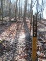
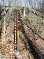
From the main parking lot, head up Bays Mountain Road to the locked service gate near the maintenance parking area. To the west is the marked trail heading into the forest. Or take Lake Road around to Azalea and head uphill to the other end.
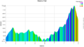
Straight level (< 1% grade) 1.6 mile single track biking path through the forest. (Trailhead sign says 1.7 mi., but measured 1.6 mi. twice.)
Hard packed trail with groove down the middle from the mountain bikes. No designed passing zones, so be careful of riders coming both ways!