Loading map...
{"format":"googlemaps3","type":"TERRAIN","minzoom":false,"maxzoom":false,"types":["SATELLITE","HYBRID","TERRAIN"],"limit":50,"offset":0,"link":"none","sort":[""],"order":[],"headers":"show","mainlabel":"","intro":"","outro":"","searchlabel":"... further results","default":"","import-annotation":false,"width":"auto","height":"600px","centre":false,"title":"","label":"","icon":"","lines":[],"polygons":[],"circles":[],"rectangles":[],"copycoords":false,"static":false,"visitedicon":"","wmsoverlay":false,"zoom":false,"layers":[],"controls":["pan","zoom","type","scale","streetview","rotate"],"zoomstyle":"DEFAULT","typestyle":"DEFAULT","autoinfowindows":false,"resizable":false,"kmlrezoom":true,"poi":true,"cluster":false,"clustergridsize":60,"clustermaxzoom":20,"clusterzoomonclick":true,"clusteraveragecenter":true,"clusterminsize":2,"imageoverlays":[],"kml":[],"gkml":["https://tehcc.org/clubwiki/images/Cherry_Knobs.kml","https://tehcc.org/clubwiki/images/Cross_Ridges_Trail.kml","https://tehcc.org/clubwiki/images/Lake_Road_(Bays_Mountain_Park).kml","https://tehcc.org/clubwiki/images/Lakeside_Trail.kml"],"searchmarkers":"","fullscreen":false,"scrollwheelzoom":false,"showtitle":false,"hidenamespace":true,"template":"Map Balloon Template","userparam":"","activeicon":"","pagelabel":false,"ajaxcoordproperty":"","ajaxquery":"","locations":[{"text":"\u003Cp\u003E\u003Cb\u003E\u003Ca class=\"mw-selflink selflink\"\u003ECherry Knobs\u003C/a\u003E\u003C/b\u003E\u003Cbr /\u003E\u003C/p\u003E\u003Chr /\u003E\u003Cp\u003E1.53\u0026#160;Mi (2.46\u0026#160;km)\u003Cbr /\u003EDifficulty: Medium\u003Cbr /\u003EMarking: Signs\u003C/p\u003E","title":"Cherry Knobs","link":"","lat":36.5057680000000033260221243835985660552978515625,"lon":-82.6181980000000066866050474345684051513671875,"icon":"/clubwiki/images/MarkerT.png"},{"text":"\u003Cp\u003E\u003Cb\u003EJunction with \u003Ca href=\"/wiki/Cross_Ridges_Trail\" title=\"Cross Ridges Trail\"\u003ECross Ridges Trail\u003C/a\u003E\u003C/b\u003E\u003Cbr /\u003E\u003C/p\u003E\u003Chr /\u003E\u003Cp\u003E\u003Ca href=\"/wiki/File:BMP_CK-CR_sign.JPG\" class=\"image\"\u003E\u003Cimg alt=\"BMP CK-CR sign.JPG\" src=\"/clubwiki/images/thumb/BMP_CK-CR_sign.JPG/50px-BMP_CK-CR_sign.JPG\" decoding=\"async\" width=\"50\" height=\"142\" srcset=\"/clubwiki/images/thumb/BMP_CK-CR_sign.JPG/75px-BMP_CK-CR_sign.JPG 1.5x, /clubwiki/images/thumb/BMP_CK-CR_sign.JPG/100px-BMP_CK-CR_sign.JPG 2x\" data-file-width=\"158\" data-file-height=\"448\" /\u003E\u003C/a\u003E\u003C/p\u003E","title":"Cherry Knobs","link":"","lat":36.4968300000000027694113668985664844512939453125,"lon":-82.636290000000002464730641804635524749755859375,"icon":"/clubwiki/images/MarkerT.png"},{"text":"\u003Cp\u003E\u003Cb\u003EHalf dozen headstones around a small clearing\u003C/b\u003E\u003Cbr /\u003E\u003C/p\u003E\u003Chr /\u003E\u003Cp\u003EHalf dozen headstones around a small clearing\u003C/p\u003E","title":"Cherry Knobs","link":"","lat":36.504829999999998335624695755541324615478515625,"lon":-82.6185799999999943565853754989802837371826171875,"icon":"/clubwiki/images/MarkerN.png"},{"text":"\u003Cp\u003E\u003Cb\u003ESpur trail to cemetery\u003C/b\u003E\u003Cbr /\u003E\u003C/p\u003E\u003Chr /\u003E\u003Cp\u003ESpur trail to cemetery\u003C/p\u003E","title":"Cherry Knobs","link":"","lat":36.50544000000000011141310096718370914459228515625,"lon":-82.6189700000000044610715121962130069732666015625,"icon":"/clubwiki/images/MarkerT.png"},{"text":"\u003Cp\u003E\u003Cb\u003EJunction with \u003Ca href=\"/wiki/Lakeside_Trail\" title=\"Lakeside Trail\"\u003ELakeside Trail\u003C/a\u003E\u003C/b\u003E\u003Cbr /\u003E\u003C/p\u003E\u003Chr /\u003E\u003Cp\u003EJunction with \u003Ca href=\"/wiki/Lakeside_Trail\" title=\"Lakeside Trail\"\u003ELakeside Trail\u003C/a\u003E\u003C/p\u003E","title":"Cherry Knobs","link":"","lat":36.50583999999999917918103164993226528167724609375,"lon":-82.618300000000004956746124662458896636962890625,"icon":"/clubwiki/images/MarkerT.png"},{"text":"\u003Cp\u003E\u003Cb\u003EJunction with \u003Ca href=\"/wiki/Lake_Road_(Bays_Mountain_Park)\" title=\"Lake Road (Bays Mountain Park)\"\u003ELake Road\u003C/a\u003E\u003C/b\u003E\u003Cbr /\u003E\u003C/p\u003E\u003Chr /\u003E\u003Cp\u003E\u003Ca href=\"/wiki/File:BMP_CK_LR_sign1.JPG\" class=\"image\"\u003E\u003Cimg alt=\"BMP CK LR sign1.JPG\" src=\"/clubwiki/images/thumb/BMP_CK_LR_sign1.JPG/50px-BMP_CK_LR_sign1.JPG\" decoding=\"async\" width=\"50\" height=\"154\" srcset=\"/clubwiki/images/thumb/BMP_CK_LR_sign1.JPG/75px-BMP_CK_LR_sign1.JPG 1.5x, /clubwiki/images/thumb/BMP_CK_LR_sign1.JPG/100px-BMP_CK_LR_sign1.JPG 2x\" data-file-width=\"145\" data-file-height=\"448\" /\u003E\u003C/a\u003E\u003C/p\u003E","title":"Cherry Knobs","link":"","lat":36.50341999999999842430042917840182781219482421875,"lon":-82.6284699999999929787009023129940032958984375,"icon":"/clubwiki/images/MarkerT.png"},{"text":"\u003Cp\u003E\u003Cb\u003EJunction with \u003Ca href=\"/wiki/Lake_Road_(Bays_Mountain_Park)\" title=\"Lake Road (Bays Mountain Park)\"\u003ELake Road\u003C/a\u003E\u003C/b\u003E\u003Cbr /\u003E\u003C/p\u003E\u003Chr /\u003E\u003Cp\u003E\u003Ca href=\"/wiki/File:BMP_CK_LR_sign2.JPG\" class=\"image\"\u003E\u003Cimg alt=\"BMP CK LR sign2.JPG\" src=\"/clubwiki/images/thumb/BMP_CK_LR_sign2.JPG/50px-BMP_CK_LR_sign2.JPG\" decoding=\"async\" width=\"50\" height=\"156\" srcset=\"/clubwiki/images/thumb/BMP_CK_LR_sign2.JPG/75px-BMP_CK_LR_sign2.JPG 1.5x, /clubwiki/images/thumb/BMP_CK_LR_sign2.JPG/100px-BMP_CK_LR_sign2.JPG 2x\" data-file-width=\"144\" data-file-height=\"448\" /\u003E\u003C/a\u003E\u003C/p\u003E","title":"Cherry Knobs","link":"","lat":36.50097199999999730835043010301887989044189453125,"lon":-82.6309739999999948167896945960819721221923828125,"icon":"/clubwiki/images/MarkerT.png"},{"text":"\u003Cp\u003E\u003Cb\u003E\u003Ca href=\"/wiki/Cross_Ridges_Trail\" title=\"Cross Ridges Trail\"\u003ECross Ridges Trail\u003C/a\u003E\u003C/b\u003E\u003Cbr /\u003E\u003C/p\u003E\u003Chr /\u003E\u003Cp\u003E0.64\u0026#160;Mi (1.03\u0026#160;km)\u003Cbr /\u003EDifficulty: Medium\u003Cbr /\u003EMarking: Signs\u003C/p\u003E","title":"Cross Ridges Trail","link":"","lat":36.49777000000000271029421128332614898681640625,"lon":-82.6427000000000049340087571181356906890869140625,"icon":"/clubwiki/images/MarkerT.png"},{"text":"\u003Cp\u003E\u003Cb\u003EJunction with \u003Ca class=\"mw-selflink selflink\"\u003ECherry Knobs\u003C/a\u003E\u003C/b\u003E\u003Cbr /\u003E\u003C/p\u003E\u003Chr /\u003E\u003Cp\u003E\u003Ca href=\"/wiki/File:BMP_CK-CR_sign.JPG\" class=\"image\"\u003E\u003Cimg alt=\"BMP CK-CR sign.JPG\" src=\"/clubwiki/images/thumb/BMP_CK-CR_sign.JPG/50px-BMP_CK-CR_sign.JPG\" decoding=\"async\" width=\"50\" height=\"142\" srcset=\"/clubwiki/images/thumb/BMP_CK-CR_sign.JPG/75px-BMP_CK-CR_sign.JPG 1.5x, /clubwiki/images/thumb/BMP_CK-CR_sign.JPG/100px-BMP_CK-CR_sign.JPG 2x\" data-file-width=\"158\" data-file-height=\"448\" /\u003E\u003C/a\u003E\u003C/p\u003E","title":"Cross Ridges Trail","link":"","lat":36.4968300000000027694113668985664844512939453125,"lon":-82.636290000000002464730641804635524749755859375,"icon":"/clubwiki/images/MarkerT.png"},{"text":"\u003Cp\u003E\u003Cb\u003EJunction with \u003Ca href=\"/wiki/Back_Hollow_Road\" title=\"Back Hollow Road\"\u003EBack Hollow Road\u003C/a\u003E\u003C/b\u003E\u003Cbr /\u003E\u003C/p\u003E\u003Chr /\u003E\u003Cp\u003Eand \u003Ca href=\"/wiki/Pretty_Ridge_Trail\" title=\"Pretty Ridge Trail\"\u003EPretty Ridge Trail\u003C/a\u003E\u003C/p\u003E","title":"Cross Ridges Trail","link":"","lat":36.49777000000000271029421128332614898681640625,"lon":-82.6426900000000017598722479306161403656005859375,"icon":"/clubwiki/images/MarkerT.png"},{"text":"\u003Cp\u003E\u003Cb\u003ETrailhead at \u003Ca href=\"/wiki/Front_Hollow_Road\" title=\"Front Hollow Road\"\u003EFront Hollow Road\u003C/a\u003E\u003C/b\u003E\u003Cbr /\u003E\u003C/p\u003E\u003Chr /\u003E\u003Cp\u003E\u003Ca href=\"/wiki/File:BMP_CR_FHR_sign.JPG\" class=\"image\"\u003E\u003Cimg alt=\"BMP CR FHR sign.JPG\" src=\"/clubwiki/images/thumb/BMP_CR_FHR_sign.JPG/50px-BMP_CR_FHR_sign.JPG\" decoding=\"async\" width=\"50\" height=\"209\" srcset=\"/clubwiki/images/thumb/BMP_CR_FHR_sign.JPG/75px-BMP_CR_FHR_sign.JPG 1.5x, /clubwiki/images/thumb/BMP_CR_FHR_sign.JPG/100px-BMP_CR_FHR_sign.JPG 2x\" data-file-width=\"107\" data-file-height=\"448\" /\u003E\u003C/a\u003E\u003C/p\u003E","title":"Cross Ridges Trail","link":"","lat":36.4951099999999968304109643213450908660888671875,"lon":-82.634379999999993060555425472557544708251953125,"icon":"/clubwiki/images/MarkerT.png"},{"text":"\u003Cp\u003E\u003Cb\u003EStream crossing - no bridge\u003C/b\u003E\u003Cbr /\u003E\u003C/p\u003E\u003Chr /\u003E\u003Cp\u003E\u003Ca href=\"/wiki/File:BMP_Cross_Ridges_Trail_stream_crossing.JPG\" class=\"image\"\u003E\u003Cimg alt=\"BMP Cross Ridges Trail stream crossing.JPG\" src=\"/clubwiki/images/thumb/BMP_Cross_Ridges_Trail_stream_crossing.JPG/150px-BMP_Cross_Ridges_Trail_stream_crossing.JPG\" decoding=\"async\" width=\"150\" height=\"200\" srcset=\"/clubwiki/images/thumb/BMP_Cross_Ridges_Trail_stream_crossing.JPG/225px-BMP_Cross_Ridges_Trail_stream_crossing.JPG 1.5x, /clubwiki/images/thumb/BMP_Cross_Ridges_Trail_stream_crossing.JPG/300px-BMP_Cross_Ridges_Trail_stream_crossing.JPG 2x\" data-file-width=\"768\" data-file-height=\"1024\" /\u003E\u003C/a\u003E\u003C/p\u003E","title":"Cross Ridges Trail","link":"","lat":36.49770000000000180762071977369487285614013671875,"lon":-82.6424999999999982946974341757595539093017578125,"icon":"/clubwiki/images/MarkerJ.png"},{"text":"\u003Cp\u003E\u003Cb\u003E\u003Ca href=\"/wiki/Lake_Road_(Bays_Mountain_Park)\" title=\"Lake Road (Bays Mountain Park)\"\u003ELake Road (Bays Mountain Park)\u003C/a\u003E\u003C/b\u003E\u003Cbr /\u003E\u003C/p\u003E\u003Chr /\u003E\u003Cp\u003E4.33\u0026#160;Mi (6.96\u0026#160;km)\u003Cbr /\u003EDifficulty: Easy\u003Cbr /\u003EMarking: Signs\u003C/p\u003E","title":"Lake Road (Bays Mountain Park)","link":"","lat":36.50645999999999702367858844809234142303466796875,"lon":-82.63128000000000383806764148175716400146484375,"icon":"/clubwiki/images/MarkerT.png"},{"text":"\u003Cp\u003E\u003Cb\u003ELedbetter Gap\u003C/b\u003E\u003Cbr /\u003E\u003C/p\u003E\u003Chr /\u003E\u003Cp\u003E\u003Ca href=\"/wiki/File:BMP_Ledbetter_Gap_sign.JPG\" class=\"image\"\u003E\u003Cimg alt=\"BMP Ledbetter Gap sign.JPG\" src=\"/clubwiki/images/thumb/BMP_Ledbetter_Gap_sign.JPG/150px-BMP_Ledbetter_Gap_sign.JPG\" decoding=\"async\" width=\"150\" height=\"148\" srcset=\"/clubwiki/images/thumb/BMP_Ledbetter_Gap_sign.JPG/225px-BMP_Ledbetter_Gap_sign.JPG 1.5x, /clubwiki/images/thumb/BMP_Ledbetter_Gap_sign.JPG/300px-BMP_Ledbetter_Gap_sign.JPG 2x\" data-file-width=\"340\" data-file-height=\"336\" /\u003E\u003C/a\u003E\u003Cbr /\u003ECrossroads with \u003Ca href=\"/wiki/Bays_Ridge_Road\" title=\"Bays Ridge Road\"\u003EBays Ridge Road\u003C/a\u003E and \u003Ca href=\"/wiki/Front_Hollow_Road\" title=\"Front Hollow Road\"\u003EFront Hollow Road\u003C/a\u003E\u003C/p\u003E","title":"Lake Road (Bays Mountain Park)","link":"","lat":36.4979000000000013415046851150691509246826171875,"lon":-82.627712999999999965439201332628726959228515625,"icon":"/clubwiki/images/MarkerT.png"},{"text":"\u003Cp\u003E\u003Cb\u003E\u003Ca href=\"/wiki/Orchid_Trail\" title=\"Orchid Trail\"\u003EOrchid Trail\u003C/a\u003E\u003C/b\u003E\u003Cbr /\u003E\u003C/p\u003E\u003Chr /\u003E\u003Cp\u003E\u003Ca href=\"/wiki/File:BMP_Orchid_Trail_sign.JPG\" class=\"image\"\u003E\u003Cimg alt=\"BMP Orchid Trail sign.JPG\" src=\"/clubwiki/images/thumb/BMP_Orchid_Trail_sign.JPG/50px-BMP_Orchid_Trail_sign.JPG\" decoding=\"async\" width=\"50\" height=\"89\" srcset=\"/clubwiki/images/thumb/BMP_Orchid_Trail_sign.JPG/75px-BMP_Orchid_Trail_sign.JPG 1.5x, /clubwiki/images/thumb/BMP_Orchid_Trail_sign.JPG/100px-BMP_Orchid_Trail_sign.JPG 2x\" data-file-width=\"252\" data-file-height=\"448\" /\u003E\u003C/a\u003E\u003C/p\u003E","title":"Lake Road (Bays Mountain Park)","link":"","lat":36.50348999999999932697392068803310394287109375,"lon":-82.618930000000005975380190648138523101806640625,"icon":"/clubwiki/images/MarkerT.png"},{"text":"\u003Cp\u003E\u003Cb\u003ECrossroads\u003C/b\u003E\u003Cbr /\u003E\u003C/p\u003E\u003Chr /\u003E\u003Cp\u003E\u003Ca href=\"/wiki/Back_Hollow_Road\" title=\"Back Hollow Road\"\u003EBack Hollow Road\u003C/a\u003E and \u003Ca href=\"/wiki/River_Mountain_Road\" title=\"River Mountain Road\"\u003ERiver Mountain Road\u003C/a\u003E\u003C/p\u003E","title":"Lake Road (Bays Mountain Park)","link":"","lat":36.50654800000000221871232497505843639373779296875,"lon":-82.6312779999999946767275105230510234832763671875,"icon":"/clubwiki/images/MarkerT.png"},{"text":"\u003Cp\u003E\u003Cb\u003EOld quarry used for stone to create reservoir dam\u003C/b\u003E\u003Cbr /\u003E\u003C/p\u003E\u003Chr /\u003E\u003Cp\u003EOld quarry used for stone to create reservoir dam\u003C/p\u003E","title":"Lake Road (Bays Mountain Park)","link":"","lat":36.50513000000000118916432256810367107391357421875,"lon":-82.6295300000000025875124265439808368682861328125,"icon":"/clubwiki/images/MarkerD.png"},{"text":"\u003Cp\u003E\u003Cb\u003E\u003Ca class=\"mw-selflink selflink\"\u003ECherry Knobs\u003C/a\u003E\u003C/b\u003E\u003Cbr /\u003E\u003C/p\u003E\u003Chr /\u003E\u003Cp\u003E\u003Ca class=\"mw-selflink selflink\"\u003ECherry Knobs\u003C/a\u003E\u003C/p\u003E","title":"Lake Road (Bays Mountain Park)","link":"","lat":36.50344799999999878536982578225433826446533203125,"lon":-82.6285299999999978126652422361075878143310546875,"icon":"/clubwiki/images/MarkerT.png"},{"text":"\u003Cp\u003E\u003Cb\u003E\u003Ca href=\"/wiki/Pine_Trail\" title=\"Pine Trail\"\u003EPine Trail\u003C/a\u003E\u003C/b\u003E\u003Cbr /\u003E\u003C/p\u003E\u003Chr /\u003E\u003Cp\u003E\u003Ca href=\"/wiki/Pine_Trail\" title=\"Pine Trail\"\u003EPine Trail\u003C/a\u003E\u003C/p\u003E","title":"Lake Road (Bays Mountain Park)","link":"","lat":36.50708800000000309182723867706954479217529296875,"lon":-82.61354000000000041836756281554698944091796875,"icon":"/clubwiki/images/MarkerT.png"},{"text":"\u003Cp\u003E\u003Cb\u003EJunction with \u003Ca href=\"/wiki/Chinquapin_Trail\" title=\"Chinquapin Trail\"\u003EChinquapin Trail\u003C/a\u003E\u003C/b\u003E\u003Cbr /\u003E\u003C/p\u003E\u003Chr /\u003E\u003Cp\u003EJunction with \u003Ca href=\"/wiki/Chinquapin_Trail\" title=\"Chinquapin Trail\"\u003EChinquapin Trail\u003C/a\u003E\u003C/p\u003E","title":"Lake Road (Bays Mountain Park)","link":"","lat":36.50945999999999713736542616970837116241455078125,"lon":-82.62130999999999403371475636959075927734375,"icon":"/clubwiki/images/MarkerT.png"},{"text":"\u003Cp\u003E\u003Cb\u003E\u003Ca class=\"mw-selflink selflink\"\u003ECherry Knobs\u003C/a\u003E\u003C/b\u003E\u003Cbr /\u003E\u003C/p\u003E\u003Chr /\u003E\u003Cp\u003E\u003Ca class=\"mw-selflink selflink\"\u003ECherry Knobs\u003C/a\u003E\u003C/p\u003E","title":"Lake Road (Bays Mountain Park)","link":"","lat":36.50097199999999730835043010301887989044189453125,"lon":-82.6309739999999948167896945960819721221923828125,"icon":"/clubwiki/images/MarkerT.png"},{"text":"\u003Cp\u003E\u003Cb\u003E\u003Ca href=\"/wiki/Bays_Ridge_Road\" title=\"Bays Ridge Road\"\u003EBays Ridge Road\u003C/a\u003E\u003C/b\u003E\u003Cbr /\u003E\u003C/p\u003E\u003Chr /\u003E\u003Cp\u003E\u003Ca href=\"/wiki/File:BMP_LakeRd-BaysRidgeRd_sign.JPG\" class=\"image\"\u003E\u003Cimg alt=\"BMP LakeRd-BaysRidgeRd sign.JPG\" src=\"/clubwiki/images/thumb/BMP_LakeRd-BaysRidgeRd_sign.JPG/50px-BMP_LakeRd-BaysRidgeRd_sign.JPG\" decoding=\"async\" width=\"50\" height=\"179\" srcset=\"/clubwiki/images/thumb/BMP_LakeRd-BaysRidgeRd_sign.JPG/75px-BMP_LakeRd-BaysRidgeRd_sign.JPG 1.5x, /clubwiki/images/thumb/BMP_LakeRd-BaysRidgeRd_sign.JPG/100px-BMP_LakeRd-BaysRidgeRd_sign.JPG 2x\" data-file-width=\"125\" data-file-height=\"448\" /\u003E\u003C/a\u003E\u003C/p\u003E","title":"Lake Road (Bays Mountain Park)","link":"","lat":36.50761299999999920373738859780132770538330078125,"lon":-82.6126579999999961501089273951947689056396484375,"icon":"/clubwiki/images/MarkerT.png"},{"text":"\u003Cp\u003E\u003Cb\u003E\u003Ca href=\"/wiki/Lakeside_Trail\" title=\"Lakeside Trail\"\u003ELakeside Trail\u003C/a\u003E\u003C/b\u003E\u003Cbr /\u003E\u003C/p\u003E\u003Chr /\u003E\u003Cp\u003E2.32\u0026#160;Mi (3.73\u0026#160;km)\u003Cbr /\u003EDifficulty: Medium\u003Cbr /\u003EMarking: Signs\u003C/p\u003E","title":"Lakeside Trail","link":"","lat":36.50889000000000095269570010714232921600341796875,"lon":-82.611400000000003274180926382541656494140625,"icon":"/clubwiki/images/MarkerT.png"},{"text":"\u003Cp\u003E\u003Cb\u003EFixed bridge\u003C/b\u003E\u003Cbr /\u003E\u003C/p\u003E\u003Chr /\u003E\u003Cp\u003EFixed bridge\u003C/p\u003E","title":"Lakeside Trail","link":"","lat":36.51131000000000170757630257867276668548583984375,"lon":-82.614429999999998699422576464712619781494140625,"icon":"/clubwiki/images/MarkerL.png"},{"text":"\u003Cp\u003E\u003Cb\u003ENo bridge at spring - pass around on uphill side\u003C/b\u003E\u003Cbr /\u003E\u003C/p\u003E\u003Chr /\u003E\u003Cp\u003ENo bridge at spring - pass around on uphill side\u003C/p\u003E","title":"Lakeside Trail","link":"","lat":36.5126699999999999590727384202182292938232421875,"lon":-82.6096299999999956753526930697262287139892578125,"icon":"/clubwiki/images/MarkerJ.png"},{"text":"\u003Cp\u003E\u003Cb\u003EFixed bridge\u003C/b\u003E\u003Cbr /\u003E\u003C/p\u003E\u003Chr /\u003E\u003Cp\u003EFixed bridge\u003C/p\u003E","title":"Lakeside Trail","link":"","lat":36.510390000000001009539118967950344085693359375,"lon":-82.616389999999995552570908330380916595458984375,"icon":"/clubwiki/images/MarkerL.png"},{"text":"\u003Cp\u003E\u003Cb\u003EFloating bridge\u003C/b\u003E\u003Cbr /\u003E\u003C/p\u003E\u003Chr /\u003E\u003Cp\u003E\u003Ca href=\"/wiki/File:BMP_Lakeside_Trail_floating_bridge.JPG\" class=\"image\"\u003E\u003Cimg alt=\"BMP Lakeside Trail floating bridge.JPG\" src=\"/clubwiki/images/thumb/BMP_Lakeside_Trail_floating_bridge.JPG/150px-BMP_Lakeside_Trail_floating_bridge.JPG\" decoding=\"async\" width=\"150\" height=\"200\" srcset=\"/clubwiki/images/thumb/BMP_Lakeside_Trail_floating_bridge.JPG/225px-BMP_Lakeside_Trail_floating_bridge.JPG 1.5x, /clubwiki/images/thumb/BMP_Lakeside_Trail_floating_bridge.JPG/300px-BMP_Lakeside_Trail_floating_bridge.JPG 2x\" data-file-width=\"768\" data-file-height=\"1024\" /\u003E\u003C/a\u003E\u003C/p\u003E","title":"Lakeside Trail","link":"","lat":36.50507999999999952933649183250963687896728515625,"lon":-82.61732000000000653017195872962474822998046875,"icon":"/clubwiki/images/MarkerL.png"},{"text":"\u003Cp\u003E\u003Cb\u003EJunction with \u003Ca class=\"mw-selflink selflink\"\u003ECherry Knobs\u003C/a\u003E\u003C/b\u003E\u003Cbr /\u003E\u003C/p\u003E\u003Chr /\u003E\u003Cp\u003EJunction with \u003Ca class=\"mw-selflink selflink\"\u003ECherry Knobs\u003C/a\u003E\u003C/p\u003E","title":"Lakeside Trail","link":"","lat":36.5057800000000014506440493278205394744873046875,"lon":-82.6183199999999970941644278354942798614501953125,"icon":"/clubwiki/images/MarkerT.png"},{"text":"\u003Cp\u003E\u003Cb\u003EBeginning of dam bridge\u003C/b\u003E\u003Cbr /\u003E\u003C/p\u003E\u003Chr /\u003E\u003Cp\u003EBeginning of dam bridge\u003C/p\u003E","title":"Lakeside Trail","link":"","lat":36.50889399999999795909388922154903411865234375,"lon":-82.611435999999997648046701215207576751708984375,"icon":"/clubwiki/images/MarkerG.png"},{"text":"\u003Cp\u003E\u003Cb\u003EFixed bridge\u003C/b\u003E\u003Cbr /\u003E\u003C/p\u003E\u003Chr /\u003E\u003Cp\u003EFixed bridge\u003C/p\u003E","title":"Lakeside Trail","link":"","lat":36.5087400000000030786395655013620853424072265625,"lon":-82.6215300000000070212990976870059967041015625,"icon":"/clubwiki/images/MarkerL.png"},{"text":"\u003Cp\u003E\u003Cb\u003EFixed bridge\u003C/b\u003E\u003Cbr /\u003E\u003C/p\u003E\u003Chr /\u003E\u003Cp\u003EFixed bridge\u003C/p\u003E","title":"Lakeside Trail","link":"","lat":36.5059600000000017416823538951575756072998046875,"lon":-82.6209999999999951114659779705107212066650390625,"icon":"/clubwiki/images/MarkerL.png"},{"text":"\u003Cp\u003E\u003Cb\u003ENew trail bridge\u003C/b\u003E\u003Cbr /\u003E\u003C/p\u003E\u003Chr /\u003E\u003Cp\u003ENew trail bridge\u003C/p\u003E","title":"Lakeside Trail","link":"","lat":36.51214999999999832880348549224436283111572265625,"lon":-82.607789999999994279278325848281383514404296875,"icon":"/clubwiki/images/MarkerL.png"}]}
The trail is not directly accessible from the main parking lot. Most folks will cross the dam and follow Lakeside Trail over the floating bridge until a Cherry Knobs trail sign is seen.
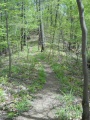
Steep trail up and along the Cherry Knobs. Trekking poles might be useful to transfer weight off legs. This trail has connections with Lake Road and Cross Ridges Trail
Between Lakeside Trail and Lake Road, the dirt and leaf-covered path head up the Cherry Knobs. The piece shared with Lake Road is wide gravel road popular with mountain biking. Between Lake Road and Cross Ridges Trail, the path is much less used thus less maintained, so many small trees and briars grow along the path. The light blue vinyl blazes fortunately guide you.
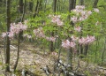
Pink azaleas can be found in the park, which would be the flowering tree similar to a cherry.