|
|
| Line 1: |
Line 1: |
| <!-- The following few lines create the "Infobox" table template. Please scroll down to edit the main content of the article. --> | | <!-- The following few lines create the "Infobox" table template. Please scroll down to edit the main content of the article. --> |
| {{Infobox Trail | | {{Infobox Trail |
| | Image Name = BMP Cherry Knobs azaleas.JPG
| | | Image Name = BMP Cherry Knobs azaleas.JPG |
| | City = Kingsport
| | | Trail Number = |
| | State = Tennessee
| | | Park = Bays Mountain Park |
| | Marking = Junction Signs
| | | City = Kingsport |
| | Trail Use = {{Hike}}{{Dogs}}
| | | State = Tennessee |
| | Difficulty Rating = Medium
| | | Marking = Signs |
| | Hike Time = 1
| | | Trail Use = {{Hike}} {{Dogs}} |
| | Distance = 1.6
| | | Difficulty Rating = Medium |
| | Elevation Gain = 292
| | | Hike Time = 60 Min |
| | High Point = 2140
| | | Round Trip Distance = 3.8 Mi |
| | Latitude = 36.49487
| | | Trail Distance = 1.55 Mi |
| | Longitude = -82.60517
| | | Trail Type = Segment |
| | Medical = Kingsport, TN
| | | Elevation Gain = 614 Ft |
| | | Elevation Loss = -548 Ft |
| | | High Point = 2,192 Ft |
| | | Parking coords = 36.508821,-82.609545 |
| | | Trailhead coords = 36.505768,-82.618198 |
| | | Medical = Kingsport, TN |
| }} | | }} |
| <!-- End Infobox template table--> | | <!-- End Infobox template table--> |
| Line 25: |
Line 30: |
| == How to get there == | | == How to get there == |
| <!-- Please enter detailed instruction on how to find the trail head. --> | | <!-- Please enter detailed instruction on how to find the trail head. --> |
| The trail is not directly accessible from the main parking lot. Most folks will cross the dam and follow [[BMP Lakeside Trail|Lakeside Trail]] over the floating bridge unti a Cherry Knobs trail sign is seen. | | The trail is not directly accessible from the main parking lot. Most folks will cross the dam and follow [[Lakeside Trail|Lakeside Trail]] over the floating bridge until a Cherry Knobs trail sign is seen. |
|
| |
|
| == Route Description== | | == Route Description== |
| <!-- Detailed description of the route. Is there any side trails that are worth traveling? --> | | <!-- Detailed description of the route. Is there any side trails that are worth traveling? --> |
| Steep trail up and along the Cherry Knobs. Trekking poles might be useful to transfer weight off legs. | | Steep trail up and along the Cherry Knobs. Trekking poles might be useful to transfer weight off legs. This trail has connections with [[Trail connects to::Lake Road (Bays Mountain Park)|Lake Road]] and [[Trail connects to::Cross Ridges Trail]] |
|
| |
|
| {| class="wikitable" border="1" | | {| class="wikitable" border="1" |
| Line 38: |
Line 43: |
| |- | | |- |
| |0.0 | | |0.0 |
| |Trailhead at [[BMP Lakeside Trail|Lakeside Trail]] | | |Trailhead at [[Lakeside Trail|Lakeside Trail]] |
| |1.6 | | |1.6 |
| |- | | |- |
| Line 46: |
Line 51: |
| |- | | |- |
| |0.7 | | |0.7 |
| |Junction with [[BMP Lake Road|Lake Road]]. Both travel together for 0.3 miles. | | |Junction with [[Lake Road (Bays Mountain Park)|Lake Road]]. Both travel together for 0.3 miles. |
| |0.9 | | |0.9 |
| |- | | |- |
| |1.0 | | |1.0 |
| |Junction with [[BMP Lake Road|Lake Road]]. To SW, light blue vinyl blazes. | | |Junction with [[Lake Road (Bays Mountain Park)|Lake Road]]. To SW, light blue vinyl blazes. |
| |0.6 | | |0.6 |
| |- | | |- |
| |1.6 | | |1.6 |
| |Trailhead at [[BMP Cross Ridges Trail|Cross Ridges Trail]] | | |Trailhead at [[Cross Ridges Trail|Cross Ridges Trail]] |
| |0.0 | | |0.0 |
| |} | | |} |
| Line 78: |
Line 83: |
| http://tehcc.org/clubwiki/kml/BMP_Cross_Ridges_Trail.kml"> | | http://tehcc.org/clubwiki/kml/BMP_Cross_Ridges_Trail.kml"> |
|
| |
|
| 36.50584,-82.61830~Junction with [[BMP Lakeside Trail|Lakeside Trail]]~ ~MarkerG.png | | 36.50584,-82.61830~Junction with [[Lakeside Trail|Lakeside Trail]]~ ~MarkerT.png |
| 36.50544,-82.61897~Spur trail to cemetery~ ~MarkerG.png | | 36.50544,-82.61897~Spur trail to cemetery~ ~MarkerT.png |
| 36.50483,-82.61858~Half dozen headstones around a small clearing~ ~MarkerN.png | | 36.50483,-82.61858~Half dozen headstones around a small clearing~ ~MarkerN.png |
| 36.50342,-82.62847~Junction with [[BMP Lake Road|Lake Road]]~[[Image:BMP CK LR sign1.JPG|50px]]~MarkerG.png | | 36.50342,-82.62847~Junction with [[Lake Road (Bays Mountain Park)|Lake Road]]~[[Image:BMP CK LR sign1.JPG|50px]]~MarkerT.png |
| 36.500972,-82.630974~Junction with [[BMP Lake Road|Lake Road]]~[[Image:BMP CK LR sign2.JPG|50px]]~MarkerG.png | | 36.500972,-82.630974~Junction with [[Lake Road (Bays Mountain Park)|Lake Road]]~[[Image:BMP CK LR sign2.JPG|50px]]~MarkerT.png |
| 36.49683,-82.63629~Junction with [[BMP Cross Ridges Trail|Cross Ridges Trail]]~[[Image:BMP CK-CR sign.JPG|50px]]~MarkerG.png | | 36.49683,-82.63629~Junction with [[Cross Ridges Trail|Cross Ridges Trail]]~[[Image:BMP CK-CR sign.JPG|50px]]~MarkerT.png |
| </display_map> | | </display_map> |
|
| |
|
| Line 99: |
Line 104: |
| <!-- Finally add the trail to any Categories it should belong to. --> | | <!-- Finally add the trail to any Categories it should belong to. --> |
| [[Category:Tennessee]] [[Category:Kingsport]] [[Category:Bays Mountain Park]] [[Category:Medium]] [[Category:Hiking]] [[Category:Dog Friendly]] | | [[Category:Tennessee]] [[Category:Kingsport]] [[Category:Bays Mountain Park]] [[Category:Medium]] [[Category:Hiking]] [[Category:Dog Friendly]] |
| | {{#set: |
| | |Trail page needs=Detail route description;Photos;Trail pins;Update 1|+sep=; |
| | }} |
|
|
|
|
|
| Trail Name
|
Cherry Knobs
|
| Park
|
Bays Mountain Park
|
| Nearest City
|
Kingsport
|
| State
|
Tennessee
|
| Trail Marking
|
Signs
|
| Trail Use/Features
|
 
|
| Difficulty Rating
|
Medium
|
| Hiking Time
|
60 Min1 Hours <br />0.0625 Days <br />
|
Distance:
round-trip/trail only
|
3.8 Mi6.115 km <br /> / 1.55 Mi2.494 km <br />
|
| Trail Type
|
Segment
|
| Climb/Descent Elevation
|
614 Ft187.147 Meters <br /> / -548 Ft-167.03 Meters <br />
|
| High Point
|
2,192 Ft730.667 Yards <br />668.122 Meters <br />
|
| Parking
|
36° 30' 31.76" N, 82° 36' 34.36" W
|
| Trailhead
|
36° 30' 20.76" N, 82° 37' 5.51" W
|
| Nearest Medical
|
Kingsport, TN
|
| Trip Reports
|
Click Here
|
|
|
Loading map... {"type":"ROADMAP","minzoom":false,"maxzoom":false,"types":["ROADMAP","SATELLITE","HYBRID","TERRAIN"],"mappingservice":"googlemaps3","width":"270px","height":"180px","centre":false,"title":"","label":"","icon":"","lines":[],"polygons":[],"circles":[],"rectangles":[],"copycoords":false,"static":false,"visitedicon":"","wmsoverlay":false,"zoom":8,"layers":[],"controls":["zoom"],"zoomstyle":"DEFAULT","typestyle":"DEFAULT","autoinfowindows":false,"resizable":false,"kmlrezoom":false,"poi":true,"cluster":false,"clustergridsize":60,"clustermaxzoom":20,"clusterzoomonclick":true,"clusteraveragecenter":true,"clusterminsize":2,"imageoverlays":[],"kml":[],"gkml":[],"searchmarkers":"","fullscreen":false,"scrollwheelzoom":false,"locations":[{"text":"","title":"","link":"","lat":36.5088209999999975252649164758622646331787109375,"lon":-82.609544999999997116901795379817485809326171875,"icon":""}]} |
|
| Show Large Map
|
|
Trail Overview
Located in Bays Mountain Park. There are no cherry trees along this trail, but a steep path up and along the Cherry Knobs - which can be noted on topo maps. High view of the reservoir.
How to get there
The trail is not directly accessible from the main parking lot. Most folks will cross the dam and follow Lakeside Trail over the floating bridge until a Cherry Knobs trail sign is seen.
Route Description
Steep trail up and along the Cherry Knobs. Trekking poles might be useful to transfer weight off legs. This trail has connections with Lake Road and Cross Ridges Trail
| Miles
|
Cherry Knobs Trail
|
Miles
|
| 0.0
|
Trailhead at Lakeside Trail
|
1.6
|
| 0.05
|
Spur trail to abandoned cemetery. One of three reported within Bays Mountain Park.
|
1.55
|
| 0.7
|
Junction with Lake Road. Both travel together for 0.3 miles.
|
0.9
|
| 1.0
|
Junction with Lake Road. To SW, light blue vinyl blazes.
|
0.6
|
| 1.6
|
Trailhead at Cross Ridges Trail
|
0.0
|
Typical Conditions
Between Lakeside Trail and Lake Road, the dirt and leaf-covered path head up the Cherry Knobs. The piece shared with Lake Road is wide gravel road popular with mountain biking. Between Lake Road and Cross Ridges Trail, the path is much less used thus less maintained, so many small trees and briars grow along the path. The light blue vinyl blazes fortunately guide you.
Regulations
NO BIKES!
Misc. Information
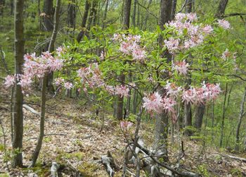
Pink azaleas can be found in the park, which would be the flowering tree similar to a cherry.
Maps
The track for Cherry Knobs Trail is shown in green. Lakeside Trail in yellow. Lake Road in orange. Cross Ridges Trail in red.
Loading map...
{"type":"TERRAIN","minzoom":false,"maxzoom":false,"types":["ROADMAP","SATELLITE","HYBRID","TERRAIN"],"mappingservice":"googlemaps3","width":"90%","height":"500px","centre":false,"title":"","label":"","icon":"","lines":[],"polygons":[],"circles":[],"rectangles":[],"copycoords":false,"static":false,"visitedicon":"","wmsoverlay":false,"zoom":false,"layers":[],"controls":["pan","zoom","type","scale","streetview","rotate"],"zoomstyle":"DEFAULT","typestyle":"DEFAULT","autoinfowindows":false,"resizable":false,"kmlrezoom":false,"poi":true,"cluster":false,"clustergridsize":60,"clustermaxzoom":20,"clusterzoomonclick":true,"clusteraveragecenter":true,"clusterminsize":2,"imageoverlays":[],"kml":[],"gkml":["http://tehcc.org/clubwiki/kml/BMP_Cherry_Knobs_Trail.kml","http://tehcc.org/clubwiki/kml/BMP_lake_road-partial.kml","http://tehcc.org/clubwiki/kml/BMP_lakeside_trail.kml","http://tehcc.org/clubwiki/kml/BMP_Cross_Ridges_Trail.kml"],"searchmarkers":"","fullscreen":false,"scrollwheelzoom":false,"locations":[{"text":"\u003Cdiv class=\"mw-parser-output\"\u003E\u003Cp\u003EJunction with \u003Ca href=\"/wiki/Lakeside_Trail\" title=\"Lakeside Trail\"\u003ELakeside Trail\u003C/a\u003E\n\u003C/p\u003E\u003C/div\u003E","title":"Junction with Lakeside Trail\n","link":"","lat":36.50583999999999917918103164993226528167724609375,"lon":-82.618300000000004956746124662458896636962890625,"icon":"/clubwiki/images/MarkerT.png"},{"text":"\u003Cdiv class=\"mw-parser-output\"\u003E\u003Cp\u003ESpur trail to cemetery\n\u003C/p\u003E\u003C/div\u003E","title":"Spur trail to cemetery\n","link":"","lat":36.50544000000000011141310096718370914459228515625,"lon":-82.6189700000000044610715121962130069732666015625,"icon":"/clubwiki/images/MarkerT.png"},{"text":"\u003Cdiv class=\"mw-parser-output\"\u003E\u003Cp\u003EHalf dozen headstones around a small clearing\n\u003C/p\u003E\u003C/div\u003E","title":"Half dozen headstones around a small clearing\n","link":"","lat":36.504829999999998335624695755541324615478515625,"lon":-82.6185799999999943565853754989802837371826171875,"icon":"/clubwiki/images/MarkerN.png"},{"text":"\u003Cb\u003E\u003Cdiv class=\"mw-parser-output\"\u003E\u003Cp\u003EJunction with \u003Ca href=\"/wiki/Lake_Road_(Bays_Mountain_Park)\" title=\"Lake Road (Bays Mountain Park)\"\u003ELake Road\u003C/a\u003E\n\u003C/p\u003E\u003C/div\u003E\u003C/b\u003E\u003Cdiv class=\"mw-parser-output\"\u003E\u003Cp\u003E\u003Ca href=\"/wiki/File:BMP_CK_LR_sign1.JPG\" class=\"image\"\u003E\u003Cimg alt=\"BMP CK LR sign1.JPG\" src=\"/clubwiki/images/thumb/BMP_CK_LR_sign1.JPG/50px-BMP_CK_LR_sign1.JPG\" decoding=\"async\" width=\"50\" height=\"154\" srcset=\"/clubwiki/images/thumb/BMP_CK_LR_sign1.JPG/75px-BMP_CK_LR_sign1.JPG 1.5x, /clubwiki/images/thumb/BMP_CK_LR_sign1.JPG/100px-BMP_CK_LR_sign1.JPG 2x\" data-file-width=\"145\" data-file-height=\"448\" /\u003E\u003C/a\u003E\n\u003C/p\u003E\u003C/div\u003E","title":"Junction with Lake Road\n","link":"","lat":36.50341999999999842430042917840182781219482421875,"lon":-82.6284699999999929787009023129940032958984375,"icon":"/clubwiki/images/MarkerT.png"},{"text":"\u003Cb\u003E\u003Cdiv class=\"mw-parser-output\"\u003E\u003Cp\u003EJunction with \u003Ca href=\"/wiki/Lake_Road_(Bays_Mountain_Park)\" title=\"Lake Road (Bays Mountain Park)\"\u003ELake Road\u003C/a\u003E\n\u003C/p\u003E\u003C/div\u003E\u003C/b\u003E\u003Cdiv class=\"mw-parser-output\"\u003E\u003Cp\u003E\u003Ca href=\"/wiki/File:BMP_CK_LR_sign2.JPG\" class=\"image\"\u003E\u003Cimg alt=\"BMP CK LR sign2.JPG\" src=\"/clubwiki/images/thumb/BMP_CK_LR_sign2.JPG/50px-BMP_CK_LR_sign2.JPG\" decoding=\"async\" width=\"50\" height=\"156\" srcset=\"/clubwiki/images/thumb/BMP_CK_LR_sign2.JPG/75px-BMP_CK_LR_sign2.JPG 1.5x, /clubwiki/images/thumb/BMP_CK_LR_sign2.JPG/100px-BMP_CK_LR_sign2.JPG 2x\" data-file-width=\"144\" data-file-height=\"448\" /\u003E\u003C/a\u003E\n\u003C/p\u003E\u003C/div\u003E","title":"Junction with Lake Road\n","link":"","lat":36.50097199999999730835043010301887989044189453125,"lon":-82.6309739999999948167896945960819721221923828125,"icon":"/clubwiki/images/MarkerT.png"},{"text":"\u003Cb\u003E\u003Cdiv class=\"mw-parser-output\"\u003E\u003Cp\u003EJunction with \u003Ca href=\"/wiki/Cross_Ridges_Trail\" title=\"Cross Ridges Trail\"\u003ECross Ridges Trail\u003C/a\u003E\n\u003C/p\u003E\u003C/div\u003E\u003C/b\u003E\u003Cdiv class=\"mw-parser-output\"\u003E\u003Cp\u003E\u003Ca href=\"/wiki/File:BMP_CK-CR_sign.JPG\" class=\"image\"\u003E\u003Cimg alt=\"BMP CK-CR sign.JPG\" src=\"/clubwiki/images/thumb/BMP_CK-CR_sign.JPG/50px-BMP_CK-CR_sign.JPG\" decoding=\"async\" width=\"50\" height=\"142\" srcset=\"/clubwiki/images/thumb/BMP_CK-CR_sign.JPG/75px-BMP_CK-CR_sign.JPG 1.5x, /clubwiki/images/thumb/BMP_CK-CR_sign.JPG/100px-BMP_CK-CR_sign.JPG 2x\" data-file-width=\"158\" data-file-height=\"448\" /\u003E\u003C/a\u003E\n\u003C/p\u003E\u003C/div\u003E","title":"Junction with Cross Ridges Trail\n","link":"","lat":36.4968300000000027694113668985664844512939453125,"lon":-82.636290000000002464730641804635524749755859375,"icon":"/clubwiki/images/MarkerT.png"}]}
- The following elevation profile travels from Lakeside Trail to Cross Ridges Trail.
File:BMP Cherry Knobs Trail profile.JPG
Photos

