Cabin Creek Trail: Difference between revisions
(recreation) |
m (add map marker back) |
||
| (4 intermediate revisions by the same user not shown) | |||
| Line 1: | Line 1: | ||
{{Trail | {{Trail | ||
|Banner Image=File:Cabin Creek Falls.jpg | |||
|Trail Highlight=Loop with a waterfall and a rhododendron tunnel | |Trail Highlight=Loop with a waterfall and a rhododendron tunnel | ||
|Park=Grayson Highlands State Park | |Park=Grayson Highlands State Park | ||
| Line 7: | Line 8: | ||
|Difficulty Rating=Medium | |Difficulty Rating=Medium | ||
|Hike Time=1 hr | |Hike Time=1 hr | ||
|Trail Distance=1. | |Trail Distance=1.8 mi | ||
|Round Trip Distance=1. | |Round Trip Distance=1.8 mi | ||
|Trail Type=Loop | |Trail Type=Loop | ||
|High Point= | |High Point=4,623 ft | ||
|Low Point= | |Low Point=4,284 ft | ||
|Elevation Gain= | |Elevation Gain=323 ft | ||
|Elevation Loss=- | |Elevation Loss=-323 ft | ||
|Elevation Change Direction=Clockwise | |Elevation Change Direction=Clockwise | ||
|Parking location=36.6333, -81.50856 | |Parking location=36.6333, -81.50856 | ||
| Line 29: | Line 30: | ||
==Route Description== | ==Route Description== | ||
It's a loop trail with moderate elevation climb. | [[File:Cabin Creek Trail profile.png|thumb|right|Profile chart]]It's a loop trail with moderate elevation climb. If you are hiking clockwise, there is a small splashdown area along the way, as well as other side trails of to the left down to the creek. These are not the main falls if resting at the falls is your plan. If you do not see the 180° turn away from the creek with the extension going forward, you are not at the falls yet. | ||
==Typical Conditions== | ==Typical Conditions== | ||
| Line 40: | Line 41: | ||
|Marker Title=Waterfall | |Marker Title=Waterfall | ||
|Marker Description=Cabin Creek Waterfall | |Marker Description=Cabin Creek Waterfall | ||
|Marker Location=36. | |Marker Location=36.636782,-81.520786 | ||
}} | }} | ||
Latest revision as of 07:58, 29 August 2020
| Cabin Creek Trail (log in to submit report) | |
|---|---|

| |
| Highlight | Loop with a waterfall and a rhododendron tunnel |
| Park | Grayson Highlands State Park |
| Located | Mouth of Wilson, VirginiaLocation inherited from associated park |
| Trail Marking | Yellow |
| Trail UseThings allowed to do on or near the trail |
|
| FeaturesThings to see on or near the trail |
|
| Difficulty Rating | Medium |
| Hiking TimeTime from car and back. Includes any time hiking to access this trail. | 1 hr0.0625 Days <br />60 Min <br /> round trip |
| Distance: | 1.8 mi2.897 km <br /> trailStrict non-repeating trail length / 1.8 mi2.897 km <br /> round tripTypical or shortest length from the car, hike the trail, and return to car |
| Trail Type | Loop |
| Low / High Point | 4,284 ft1,428 Yards <br />1,305.763 Meters <br /> / 4,623 ft1,541 Yards <br />1,409.09 Meters <br /> |
| Elev. Gain/LossSee link for details of calculation. Gain/Loss is direction dependent. | 323 ft98.45 Meters <br /> / (-323 ft-98.45 Meters <br />) – Clockwise |
| Trip ReportsFrom user "hiked it" submissions<br />Recent is within last 90 days | 1 logged hikes (0 recent) |
| NearbyWithin 5 mi<br />Click link to view list | No other Trails within 5 mi |
| Parking | 36° 37' 59.88" N, 81° 30' 30.82" W Map |
| Trailhead | 36° 38' 2.18" N, 81° 30' 40.61" W Map |
|
| |
| Show In Google Maps | |
Download KML / Upload new version / KML File Page / Create Profile Chart / gpsvisualizer Map
Trail Overview[edit]
A nice loop trail with a nice waterfall and if timed right in late spring, you'll walk through a rhododendron tunnel.
How To Get There[edit]
From the Massie Gap parking lot, head down and to the left and follow the horse trail/road until you see the livestock fence zig-zag. Trail begins here.
Route Description[edit]

It's a loop trail with moderate elevation climb. If you are hiking clockwise, there is a small splashdown area along the way, as well as other side trails of to the left down to the creek. These are not the main falls if resting at the falls is your plan. If you do not see the 180° turn away from the creek with the extension going forward, you are not at the falls yet.
Typical Conditions[edit]
Popular trail of the park and should be found in good condition
Gallery[edit]
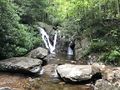
View of the falls

Trail Profile