Loading map...
{"format":"googlemaps3","type":"TERRAIN","minzoom":false,"maxzoom":false,"types":["SATELLITE","HYBRID","TERRAIN"],"limit":50,"offset":0,"link":"none","sort":[""],"order":[],"headers":"show","mainlabel":"","intro":"","outro":"","searchlabel":"... further results","default":"","import-annotation":false,"width":"auto","height":"600px","centre":false,"title":"","label":"","icon":"","lines":[],"polygons":[],"circles":[],"rectangles":[],"copycoords":false,"static":false,"visitedicon":"","wmsoverlay":false,"zoom":false,"layers":[],"controls":["pan","zoom","type","scale","streetview","rotate"],"zoomstyle":"DEFAULT","typestyle":"DEFAULT","autoinfowindows":false,"resizable":false,"kmlrezoom":true,"poi":true,"cluster":false,"clustergridsize":60,"clustermaxzoom":20,"clusterzoomonclick":true,"clusteraveragecenter":true,"clusterminsize":2,"imageoverlays":[],"kml":[],"gkml":["https://tehcc.org/clubwiki/images/Blue_2.kml","https://tehcc.org/clubwiki/images/Ridge_Top_(Roan_Mountain_State_Park).kml"],"searchmarkers":"","fullscreen":false,"scrollwheelzoom":false,"showtitle":false,"hidenamespace":true,"template":"Map Balloon Template","userparam":"","activeicon":"","pagelabel":false,"ajaxcoordproperty":"","ajaxquery":"","locations":[{"text":"\u003Cp\u003E\u003Cb\u003E\u003Ca class=\"mw-selflink selflink\"\u003EBlue 2\u003C/a\u003E\u003C/b\u003E\u003Cbr /\u003E\u003C/p\u003E\u003Chr /\u003E\u003Cp\u003E1.51\u0026#160;Mi (2.43\u0026#160;km)\u003Cbr /\u003EDifficulty: Medium\u003Cbr /\u003EMarking: Blue\u003C/p\u003E","title":"Blue 2","link":"","lat":36.16787000000000062982508097775280475616455078125,"lon":-82.09696999999999889041646383702754974365234375,"icon":"/clubwiki/images/MarkerT.png"},{"text":"\u003Cp\u003E\u003Cb\u003EParking\u003C/b\u003E\u003Cbr /\u003E\u003C/p\u003E\u003Chr /\u003E\u003Cp\u003E\u003Ca href=\"/wiki/File:Blue_2_Trail_Head.jpg\" class=\"image\" title=\"Trail head sign\"\u003E\u003Cimg alt=\"Trail head sign\" src=\"/clubwiki/images/thumb/Blue_2_Trail_Head.jpg/150px-Blue_2_Trail_Head.jpg\" decoding=\"async\" width=\"150\" height=\"200\" srcset=\"/clubwiki/images/thumb/Blue_2_Trail_Head.jpg/225px-Blue_2_Trail_Head.jpg 1.5x, /clubwiki/images/thumb/Blue_2_Trail_Head.jpg/300px-Blue_2_Trail_Head.jpg 2x\" data-file-width=\"768\" data-file-height=\"1024\" /\u003E\u003C/a\u003E\u003C/p\u003E","title":"Blue 2","link":"","lat":36.16786599999999651799953426234424114227294921875,"lon":-82.0969649999999973033482092432677745819091796875,"icon":"/clubwiki/images/MarkerA.png"},{"text":"\u003Cp\u003E\u003Cb\u003EStream bridge crossing\u003C/b\u003E\u003Cbr /\u003E\u003C/p\u003E\u003Chr /\u003E\u003Cp\u003EStream bridge crossing\u003C/p\u003E","title":"Blue 2","link":"","lat":36.1670069999999981291693984530866146087646484375,"lon":-82.1017480000000006157279131002724170684814453125,"icon":"/clubwiki/images/MarkerL.png"},{"text":"\u003Cp\u003E\u003Cb\u003EStream bridge crossing\u003C/b\u003E\u003Cbr /\u003E\u003C/p\u003E\u003Chr /\u003E\u003Cp\u003EStream bridge crossing\u003C/p\u003E","title":"Blue 2","link":"","lat":36.16781499999999738292899564839899539947509765625,"lon":-82.09940000000000281943357549607753753662109375,"icon":"/clubwiki/images/MarkerL.png"},{"text":"\u003Cp\u003E\u003Cb\u003ETrail head with \u003Ca href=\"/wiki/Ridge_Top_(Roan_Mountain_State_Park)\" title=\"Ridge Top (Roan Mountain State Park)\"\u003ERidge Top\u003C/a\u003E\u003C/b\u003E\u003Cbr /\u003E\u003C/p\u003E\u003Chr /\u003E\u003Cp\u003ERidge Top to the left, Blue 2 right\u003C/p\u003E","title":"Blue 2","link":"","lat":36.167416000000002895831130445003509521484375,"lon":-82.098804000000001224179868586361408233642578125,"icon":"/clubwiki/images/MarkerT.png"},{"text":"\u003Cp\u003E\u003Cb\u003EOld foundation\u003C/b\u003E\u003Cbr /\u003E\u003C/p\u003E\u003Chr /\u003E\u003Cp\u003E\u003Ca href=\"/wiki/File:Blue_2_Foundation.jpg\" class=\"image\" title=\"Foundation\"\u003E\u003Cimg alt=\"Foundation\" src=\"/clubwiki/images/thumb/Blue_2_Foundation.jpg/150px-Blue_2_Foundation.jpg\" decoding=\"async\" width=\"150\" height=\"113\" srcset=\"/clubwiki/images/thumb/Blue_2_Foundation.jpg/225px-Blue_2_Foundation.jpg 1.5x, /clubwiki/images/thumb/Blue_2_Foundation.jpg/300px-Blue_2_Foundation.jpg 2x\" data-file-width=\"1280\" data-file-height=\"960\" /\u003E\u003C/a\u003E\u003C/p\u003E","title":"Blue 2","link":"","lat":36.16749800000000192312654689885675907135009765625,"lon":-82.097858999999999696228769607841968536376953125,"icon":"/clubwiki/images/MarkerV.png"},{"text":"\u003Cp\u003E\u003Cb\u003E\u003Ca href=\"/wiki/Ridge_Top_(Roan_Mountain_State_Park)\" title=\"Ridge Top (Roan Mountain State Park)\"\u003ERidge Top (Roan Mountain State Park)\u003C/a\u003E\u003C/b\u003E\u003Cbr /\u003E\u003C/p\u003E\u003Chr /\u003E\u003Cp\u003E0.23\u0026#160;Mi (0.37\u0026#160;km)\u003Cbr /\u003EDifficulty: Easy\u003Cbr /\u003EMarking: Yellow\u003C/p\u003E","title":"Ridge Top (Roan Mountain State Park)","link":"","lat":36.16741999999999990222931955941021442413330078125,"lon":-82.0987999999999971123543218709528446197509765625,"icon":"/clubwiki/images/MarkerT.png"},{"text":"\u003Cp\u003E\u003Cb\u003EStream bridge crossing\u003C/b\u003E\u003Cbr /\u003E\u003C/p\u003E\u003Chr /\u003E\u003Cp\u003EStream bridge crossing\u003C/p\u003E","title":"Ridge Top (Roan Mountain State Park)","link":"","lat":36.1670069999999981291693984530866146087646484375,"lon":-82.1017480000000006157279131002724170684814453125,"icon":"/clubwiki/images/MarkerL.png"},{"text":"\u003Cp\u003E\u003Cb\u003EOld foundation\u003C/b\u003E\u003Cbr /\u003E\u003C/p\u003E\u003Chr /\u003E\u003Cp\u003EOld foundation\u003C/p\u003E","title":"Ridge Top (Roan Mountain State Park)","link":"","lat":36.16749800000000192312654689885675907135009765625,"lon":-82.097858999999999696228769607841968536376953125,"icon":"/clubwiki/images/MarkerV.png"}]}
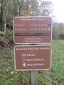
Hike begins just past the parking lot heading into the woods. Note that on my trip I could not find the "official" Blue 2 route as I couldn't find the loop connector. The "clear" trail was to hike out on Ridge Top and return on Blue 2.
The trails are fairly well maintained and blazed fairly clearly with the exception of the Ridge Top connector. As I now recall, it may have been blazed blue as well.
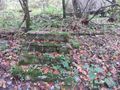
A foundation was found along the trail along with the occasional fence post. No information about the history of this structure is known, but other than the Miller Homestead, the only signs of past lives within the park that I have found.


