Blue 2: Difference between revisions
(Add pictures) |
m (remove wpsp reference) |
||
| (6 intermediate revisions by the same user not shown) | |||
| Line 1: | Line 1: | ||
{{Trail | |||
|Banner Image=File:Blue 2 View.jpg | |||
|Trail Highlight=One of the two trail mountain bike system at the park | |||
|Park=Roan Mountain State Park | |||
|Trail Marking=Blue | |||
|Trail Use=Hiking, Biking | |||
|Trail Features=Vistas | |||
|Difficulty Rating=Medium | |||
|Hike Time=1 hour | |||
|Trail Distance=1.507 mi | |||
|Round Trip Distance=2.0 mi | |||
|Trail Type=Loop | |||
|High Point=3,025 ft | |||
|Low Point=2,850 ft | |||
|Elevation Gain=146 ft | |||
|Elevation Loss=216 ft | |||
|Elevation Change Direction=Clockwise | |||
|Parking location=36.16787, -82.09697 | |||
|Trailhead location=36.16787, -82.09697 | |||
}} | |||
{{Trail Map|Other Trails=Ridge Top (Roan Mountain State Park)}} | |||
__TOC__ | |||
== Trail Overview == | == Trail Overview == | ||
<!-- Enter a overview of the trail. What attracts you to this trail, points of interest, types of flowers, lakes, and peaks that you see along the way. --> | <!-- Enter a overview of the trail. What attracts you to this trail, points of interest, types of flowers, lakes, and peaks that you see along the way. --> | ||
| Line 51: | Line 34: | ||
== Route Description== | == Route Description== | ||
[[File:Blue 2 profile.png|thumb|right]] | |||
Hike begins just past the parking lot heading into the woods. Note that on my trip I could not find the "official" Blue 2 route as I couldn't find the loop connector. The "clear" trail was to hike out on [[Trail connects to::Ridge Top (Roan Mountain State Park)|Ridge Top]] and return on Blue 2. | Hike begins just past the parking lot heading into the woods. Note that on my trip I could not find the "official" Blue 2 route as I couldn't find the loop connector. The "clear" trail was to hike out on [[Trail connects to::Ridge Top (Roan Mountain State Park)|Ridge Top]] and return on Blue 2. | ||
| Line 61: | Line 44: | ||
<!-- Enter any additional information that doesn't fit an any other fields. Any seasonal features, factoids, etc...? --> | <!-- Enter any additional information that doesn't fit an any other fields. Any seasonal features, factoids, etc...? --> | ||
A foundation was found along the trail along with the occasional fence post. No information about the history of this structure is known, but other than the Miller Homestead, the only signs of past lives within the park that I have found. | A foundation was found along the trail along with the occasional fence post. No information about the history of this structure is known, but other than the Miller Homestead, the only signs of past lives within the park that I have found. | ||
== Photos == | == Photos == | ||
{{Park trail gallery|Trail={{PAGENAME}}}} | |||
{{Map Marker | |||
|Icon Type=Parking | |||
|Marker Title=Parking | |||
Image:Blue 2 Trail Head.jpg|Trail head sign | |Marker Description=[[Image:Blue 2 Trail Head.jpg|150px|Trail head sign]] | ||
|Marker Location=36.167866,-82.096965 | |||
}} | |||
{{Map Marker | |||
|Icon Type=Old structure | |||
[[ | |Marker Title=Old foundation | ||
|Marker Description=[[Image:Blue 2 Foundation.jpg|150px|Foundation]] | |||
|Marker Location=36.167498,-82.097859 | |||
}} | |||
{{Map Marker | |||
|Icon Type=Trail sign | |||
|Marker Title=Trail head with [[Ridge Top (Roan Mountain State Park)|Ridge Top]] | |||
|Marker Description=Ridge Top to the left, Blue 2 right | |||
|Marker Location=36.167416,-82.098804 | |||
}} | |||
{{Map Marker | |||
|Icon Type=Trail bridge | |||
|Marker Title=Stream bridge crossing | |||
|Marker Location=36.167815,-82.099400 | |||
}} | |||
{{Map Marker | |||
|Icon Type=Trail bridge | |||
|Marker Title=Stream bridge crossing | |||
|Marker Location=36.167007,-82.101748 | |||
}} | |||
Latest revision as of 00:56, 31 December 2019
| Blue 2 (log in to submit report) | |
|---|---|

| |
| Highlight | One of the two trail mountain bike system at the park |
| Park | Roan Mountain State Park |
| Located | Roan Mountain, TennesseeLocation inherited from associated park |
| Trail Marking | Blue |
| Trail UseThings allowed to do on or near the trail |
|
| FeaturesThings to see on or near the trail |
|
| Difficulty Rating | Medium |
| Hiking TimeTime from car and back. Includes any time hiking to access this trail. | 1 hour0.0625 Days <br />60 Min <br /> round trip |
| Distance: | 1.507 mi2.425 km <br /> trailStrict non-repeating trail length / 2.0 mi3.219 km <br /> round tripTypical or shortest length from the car, hike the trail, and return to car |
| Trail Type | Loop |
| Low / High Point | 2,850 ft950 Yards <br />868.68 Meters <br /> / 3,025 ft1,008.333 Yards <br />922.02 Meters <br /> |
| Elev. Gain/LossSee link for details of calculation. Gain/Loss is direction dependent. | 146 ft44.501 Meters <br /> / (216 ft65.837 Meters <br />) – Clockwise |
| Trip ReportsFrom user "hiked it" submissions<br />Recent is within last 90 days | No hikes logged yet |
| NearbyWithin 5 mi<br />Click link to view list | 12 trails / 49.1 mi of trail |
| Parking | 36° 10' 4.33" N, 82° 5' 49.09" W Map |
| Trailhead | 36° 10' 4.33" N, 82° 5' 49.09" W Map |
|
| |
| Show In Google Maps | |
Download KML / Upload new version / KML File Page / Create Profile Chart / gpsvisualizer Map
Trail Overview[edit]
This is part of the Roan Mountain State Park trail system and along with Ridge Top constitutes the Mountain Bike Trails of Roan Mountain State Park
How to get there[edit]
From the Visitor's Center:
- Take TN143 South into the park
- Past the picnic area with the bathrooms with the 'π' windows, immediately before the Doe River bridge park at the lot on your right, if you pass the cabin entrance on your left, you have gone too far.
Route Description[edit]

Hike begins just past the parking lot heading into the woods. Note that on my trip I could not find the "official" Blue 2 route as I couldn't find the loop connector. The "clear" trail was to hike out on Ridge Top and return on Blue 2.
Typical Conditions[edit]
The trails are fairly well maintained and blazed fairly clearly with the exception of the Ridge Top connector. As I now recall, it may have been blazed blue as well.
Misc. Information[edit]
A foundation was found along the trail along with the occasional fence post. No information about the history of this structure is known, but other than the Miller Homestead, the only signs of past lives within the park that I have found.
Photos[edit]
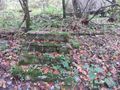
Foundation
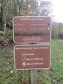
Trail head sign
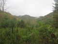
View

Trail Profile

