|
|
| (12 intermediate revisions by 2 users not shown) |
| Line 1: |
Line 1: |
| <!-- The following few lines create the "Infobox" table template. Please scroll down to edit the main content of the article. -->
| | {{Trail |
| {{Infobox Trail | | |Banner Image=File:Blue 2 View.jpg |
| | Image Name = Placeholder.gif
| | |Trail Highlight=One of the two trail mountain bike system at the park |
| | Park = Roan Mountain State Parke
| | |Park=Roan Mountain State Park |
| | City = Roan Mountain
| | |Trail Marking=Blue |
| | State = Tennessee
| | |Trail Use=Hiking, Biking |
| | Marking = Blue
| | |Trail Features=Vistas |
| | Trail Use = {{Hike}} {{Biking}} {{Dogs}}
| | |Difficulty Rating=Medium |
| | Difficulty Rating = Medium
| | |Hike Time=1 hour |
| | Hike Time = 1 Hour
| | |Trail Distance=1.507 mi |
| | Round Trip Distance = 1.4 Miles
| | |Round Trip Distance=2.0 mi |
| | Trail Distance = 1.4 Miles
| | |Trail Type=Loop |
| | Trail Type = Loop
| | |High Point=3,025 ft |
| | Elevation Gain =
| | |Low Point=2,850 ft |
| | Elevation Loss =
| | |Elevation Gain=146 ft |
| | High Point =
| | |Elevation Loss=216 ft |
| | Latitude = OBSOLETE - Latitude location of parking location in decimal format
| | |Elevation Change Direction=Clockwise |
| | Longitude = OBSOLETE - Longitude location of parking location in decimal format
| | |Parking location=36.16787, -82.09697 |
| | Parking coords = 36.166706,-82.098770
| | |Trailhead location=36.16787, -82.09697 |
| | Trailhead coords = 36.166706,-82.098770
| |
| | Medical = Elizabethton, TN
| |
| }} | | }} |
| <!-- End Infobox template table-->
| | {{Trail Map|Other Trails=Ridge Top (Roan Mountain State Park)}} |
| <!-- Start of Main Page -->
| | |
| | __TOC__ |
| | |
| == Trail Overview == | | == Trail Overview == |
| <!-- Enter a overview of the trail. What attracts you to this trail, points of interest, types of flowers, lakes, and peaks that you see along the way. --> | | <!-- Enter a overview of the trail. What attracts you to this trail, points of interest, types of flowers, lakes, and peaks that you see along the way. --> |
| This is part of the [[Roan Mountain State Park]] trail system | | This is part of the [[Roan Mountain State Park]] trail system and along with [[Ridge Top (Roan Mountain State Park)|Ridge Top]] constitutes the Mountain Bike Trails of Roan Mountain State Park |
|
| |
|
| == How to get there == | | == How to get there == |
| <!-- Please enter detailed instruction on how to find the trail head. --> | | <!-- Please enter detailed instruction on how to find the trail head. --> |
| From Johnson City (I-26 Exit 24): | | From the [[Roan Mountain State Park|Visitor's Center]]: |
| #Take TN67/US321 over to Elizabethton (about eight miles). | | #Take TN143 South into the park |
| #Turn right/south at traffic light for TN37/US19E/US321 and travel for 17 miles.
| | #Past the picnic area with the bathrooms with the 'π' windows, immediately before the Doe River bridge park at the lot on your right, if you pass the cabin entrance on your left, you have gone too far. |
| #Turn right/south for TN143 for five miles to park visitors center.
| |
| #Trailheads are in several places around the park. | |
| GPS address is 1015 Hwy 143 Roan Mountain, TN 37687.
| |
|
| |
|
| == Route Description== | | == Route Description== |
| <!-- Detailed description of the route. Is there any side trails that are worth traveling? -->
| | [[File:Blue 2 profile.png|thumb|right]] |
| A small "system" of trails offering loops to explore.
| | Hike begins just past the parking lot heading into the woods. Note that on my trip I could not find the "official" Blue 2 route as I couldn't find the loop connector. The "clear" trail was to hike out on [[Trail connects to::Ridge Top (Roan Mountain State Park)|Ridge Top]] and return on Blue 2. |
|
| |
|
| == Typical Conditions == | | == Typical Conditions == |
| <!-- Typical conditions throughout the year of what to expect on the trail. Rocky, muddy, sandy, flowers, lots of downed trees? --> | | <!-- Typical conditions throughout the year of what to expect on the trail. Rocky, muddy, sandy, flowers, lots of downed trees? --> |
| Being a TN state park, the dirt and gravel trails are kept in good condition. Some of the trail sections are steep, thus can be slippery after a rain.
| | The trails are fairly well maintained and blazed fairly clearly with the exception of the Ridge Top connector. As I now recall, it may have been blazed blue as well. |
| | |
| ==Fees, Permits, etc. ==
| |
| <!-- Please list any Fees, Permits, Regulations, etc. that may be required on this trail.-->
| |
|
| |
|
| == Misc. Information == | | == Misc. Information == |
| <!-- Enter any additional information that doesn't fit an any other fields. Any seasonal features, factoids, etc...? --> | | <!-- Enter any additional information that doesn't fit an any other fields. Any seasonal features, factoids, etc...? --> |
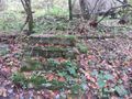
| | | A foundation was found along the trail along with the occasional fence post. No information about the history of this structure is known, but other than the Miller Homestead, the only signs of past lives within the park that I have found. |
| == After the Hike ==
| |
| <!-- Other things to check out while you're in the area. Restaurants, attractions, monuments, etc... -->
| |
| After a hike, check out Bob's Dairyland back down in Roan Mountain.
| |
| | |
| == Maps ==
| |
| <!-- You can place pictures, PDF's, links, or even create a Google map with your waypoints and place it here. -->
| |
| <display_map center="36.166706,-82.098770" type="terrain" zoom="14" width="auto" height="550">
| |
| </display_map>
| |
|
| |
|
| == Photos == | | == Photos == |
| <gallery>
| | {{Park trail gallery|Trail={{PAGENAME}}}} |
| <!-- Place any pictures from this trail below. Ideally we would have a picture of the trailhead to help people know when they found it -->
| | {{Map Marker |
| <!-- Add a picture by typing Image:imagename.extension -->
| | |Icon Type=Parking |
| Image:placeholder.jpg|caption | | |Marker Title=Parking |
| <!-- Do not remove the end gallery code.-->
| | |Marker Description=[[Image:Blue 2 Trail Head.jpg|150px|Trail head sign]] |
| </gallery>
| | |Marker Location=36.167866,-82.096965 |
| | | }} |
| <!-- Finally add the trail to any Categories it should belong to. -->
| | {{Map Marker |
| [[Category:Tennessee]] [[Category:Medium]] [[Category:Hiking]] [[Category:Dog Friendly]] [[Category:No Trail KML]] [[Category:Stub]] | | |Icon Type=Old structure |
| | |Marker Title=Old foundation |
| | |Marker Description=[[Image:Blue 2 Foundation.jpg|150px|Foundation]] |
| | |Marker Location=36.167498,-82.097859 |
| | }} |
| | {{Map Marker |
| | |Icon Type=Trail sign |
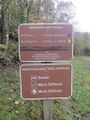
| | |Marker Title=Trail head with [[Ridge Top (Roan Mountain State Park)|Ridge Top]] |
| | |Marker Description=Ridge Top to the left, Blue 2 right |
| | |Marker Location=36.167416,-82.098804 |
| | }} |
| | {{Map Marker |
| | |Icon Type=Trail bridge |
| | |Marker Title=Stream bridge crossing |
| | |Marker Location=36.167815,-82.099400 |
| | }} |
| | {{Map Marker |
| | |Icon Type=Trail bridge |
| | |Marker Title=Stream bridge crossing |
| | |Marker Location=36.167007,-82.101748 |
| | }} |
| Blue 2
(log in to submit report)
|
|
|
|
| Highlight
|
One of the two trail mountain bike system at the park
|
| Park
|
Roan Mountain State Park
|
| Located
|
Roan Mountain, TennesseeLocation inherited from associated park
|
| Trail Marking
|
Blue
|
| Trail UseThings allowed to do on or near the trail
|
 
|
| FeaturesThings to see on or near the trail
|

|
| Difficulty Rating
|
Medium
|
| Hiking TimeTime from car and back. Includes any time hiking to access this trail.
|
1 hour0.0625 Days <br />60 Min <br /> round trip
|
| Distance:
|
1.507 mi2.425 km <br /> trailStrict non-repeating trail length / 2.0 mi3.219 km <br /> round tripTypical or shortest length from the car, hike the trail, and return to car
|
| Trail Type
|
Loop
|
| Low / High Point
|
2,850 ft950 Yards <br />868.68 Meters <br /> / 3,025 ft1,008.333 Yards <br />922.02 Meters <br />
|
| Elev. Gain/LossSee link for details of calculation. Gain/Loss is direction dependent.
|
146 ft44.501 Meters <br /> / (216 ft65.837 Meters <br />) – Clockwise
|
| Trip ReportsFrom user "hiked it" submissions<br />Recent is within last 90 days
|
No hikes logged yet
|
| NearbyWithin 5 mi<br />Click link to view list
|
12 trails / 49.1 mi of trail
|
| Parking
|
36° 10' 4.33" N, 82° 5' 49.09" W Map
|
| Trailhead
|
36° 10' 4.33" N, 82° 5' 49.09" W Map
|
Loading map... {"type":"ROADMAP","minzoom":false,"maxzoom":false,"types":["ROADMAP","SATELLITE","HYBRID","TERRAIN"],"mappingservice":"googlemaps3","width":"100%","height":"180px","centre":false,"title":"","label":"","icon":"","lines":[],"polygons":[],"circles":[],"rectangles":[],"copycoords":false,"static":false,"visitedicon":"","wmsoverlay":false,"zoom":8,"layers":[],"controls":[""],"zoomstyle":"DEFAULT","typestyle":"DEFAULT","autoinfowindows":false,"resizable":false,"kmlrezoom":false,"poi":true,"cluster":false,"clustergridsize":60,"clustermaxzoom":20,"clusterzoomonclick":true,"clusteraveragecenter":true,"clusterminsize":2,"imageoverlays":[],"kml":[],"gkml":[],"searchmarkers":"","fullscreen":false,"scrollwheelzoom":false,"locations":[{"text":"\u003Cb\u003E\u003Cdiv class=\"mw-parser-output\"\u003E\u003Cp\u003EBlue 2\n\u003C/p\u003E\u003C/div\u003E\u003C/b\u003E\u003Cdiv class=\"mw-parser-output\"\u003E\u003Cp\u003EMain Parking Location\n\u003C/p\u003E\u003C/div\u003E","title":"Blue 2\n","link":"","lat":36.16787000000000062982508097775280475616455078125,"lon":-82.09696999999999889041646383702754974365234375,"icon":""}]} |
| Show In Google Maps
|
Loading map...
{"format":"googlemaps3","type":"TERRAIN","minzoom":false,"maxzoom":false,"types":["SATELLITE","HYBRID","TERRAIN"],"limit":50,"offset":0,"link":"none","sort":[""],"order":[],"headers":"show","mainlabel":"","intro":"","outro":"","searchlabel":"... further results","default":"","import-annotation":false,"width":"auto","height":"600px","centre":false,"title":"","label":"","icon":"","lines":[],"polygons":[],"circles":[],"rectangles":[],"copycoords":false,"static":false,"visitedicon":"","wmsoverlay":false,"zoom":false,"layers":[],"controls":["pan","zoom","type","scale","streetview","rotate"],"zoomstyle":"DEFAULT","typestyle":"DEFAULT","autoinfowindows":false,"resizable":false,"kmlrezoom":true,"poi":true,"cluster":false,"clustergridsize":60,"clustermaxzoom":20,"clusterzoomonclick":true,"clusteraveragecenter":true,"clusterminsize":2,"imageoverlays":[],"kml":[],"gkml":["https://tehcc.org/clubwiki/images/Blue_2.kml","https://tehcc.org/clubwiki/images/Ridge_Top_(Roan_Mountain_State_Park).kml"],"searchmarkers":"","fullscreen":false,"scrollwheelzoom":false,"showtitle":false,"hidenamespace":true,"template":"Map Balloon Template","userparam":"","activeicon":"","pagelabel":false,"ajaxcoordproperty":"","ajaxquery":"","locations":[{"text":"\u003Cp\u003E\u003Cb\u003E\u003Ca class=\"mw-selflink selflink\"\u003EBlue 2\u003C/a\u003E\u003C/b\u003E\u003Cbr /\u003E\u003C/p\u003E\u003Chr /\u003E\u003Cp\u003E1.51\u0026#160;Mi (2.43\u0026#160;km)\u003Cbr /\u003EDifficulty: Medium\u003Cbr /\u003EMarking: Blue\u003C/p\u003E","title":"Blue 2","link":"","lat":36.16787000000000062982508097775280475616455078125,"lon":-82.09696999999999889041646383702754974365234375,"icon":"/clubwiki/images/MarkerT.png"},{"text":"\u003Cp\u003E\u003Cb\u003EParking\u003C/b\u003E\u003Cbr /\u003E\u003C/p\u003E\u003Chr /\u003E\u003Cp\u003E\u003Ca href=\"/wiki/File:Blue_2_Trail_Head.jpg\" class=\"image\" title=\"Trail head sign\"\u003E\u003Cimg alt=\"Trail head sign\" src=\"/clubwiki/images/thumb/Blue_2_Trail_Head.jpg/150px-Blue_2_Trail_Head.jpg\" decoding=\"async\" width=\"150\" height=\"200\" srcset=\"/clubwiki/images/thumb/Blue_2_Trail_Head.jpg/225px-Blue_2_Trail_Head.jpg 1.5x, /clubwiki/images/thumb/Blue_2_Trail_Head.jpg/300px-Blue_2_Trail_Head.jpg 2x\" data-file-width=\"768\" data-file-height=\"1024\" /\u003E\u003C/a\u003E\u003C/p\u003E","title":"Blue 2","link":"","lat":36.16786599999999651799953426234424114227294921875,"lon":-82.0969649999999973033482092432677745819091796875,"icon":"/clubwiki/images/MarkerA.png"},{"text":"\u003Cp\u003E\u003Cb\u003EStream bridge crossing\u003C/b\u003E\u003Cbr /\u003E\u003C/p\u003E\u003Chr /\u003E\u003Cp\u003EStream bridge crossing\u003C/p\u003E","title":"Blue 2","link":"","lat":36.1670069999999981291693984530866146087646484375,"lon":-82.1017480000000006157279131002724170684814453125,"icon":"/clubwiki/images/MarkerL.png"},{"text":"\u003Cp\u003E\u003Cb\u003EStream bridge crossing\u003C/b\u003E\u003Cbr /\u003E\u003C/p\u003E\u003Chr /\u003E\u003Cp\u003EStream bridge crossing\u003C/p\u003E","title":"Blue 2","link":"","lat":36.16781499999999738292899564839899539947509765625,"lon":-82.09940000000000281943357549607753753662109375,"icon":"/clubwiki/images/MarkerL.png"},{"text":"\u003Cp\u003E\u003Cb\u003ETrail head with \u003Ca href=\"/wiki/Ridge_Top_(Roan_Mountain_State_Park)\" title=\"Ridge Top (Roan Mountain State Park)\"\u003ERidge Top\u003C/a\u003E\u003C/b\u003E\u003Cbr /\u003E\u003C/p\u003E\u003Chr /\u003E\u003Cp\u003ERidge Top to the left, Blue 2 right\u003C/p\u003E","title":"Blue 2","link":"","lat":36.167416000000002895831130445003509521484375,"lon":-82.098804000000001224179868586361408233642578125,"icon":"/clubwiki/images/MarkerT.png"},{"text":"\u003Cp\u003E\u003Cb\u003EOld foundation\u003C/b\u003E\u003Cbr /\u003E\u003C/p\u003E\u003Chr /\u003E\u003Cp\u003E\u003Ca href=\"/wiki/File:Blue_2_Foundation.jpg\" class=\"image\" title=\"Foundation\"\u003E\u003Cimg alt=\"Foundation\" src=\"/clubwiki/images/thumb/Blue_2_Foundation.jpg/150px-Blue_2_Foundation.jpg\" decoding=\"async\" width=\"150\" height=\"113\" srcset=\"/clubwiki/images/thumb/Blue_2_Foundation.jpg/225px-Blue_2_Foundation.jpg 1.5x, /clubwiki/images/thumb/Blue_2_Foundation.jpg/300px-Blue_2_Foundation.jpg 2x\" data-file-width=\"1280\" data-file-height=\"960\" /\u003E\u003C/a\u003E\u003C/p\u003E","title":"Blue 2","link":"","lat":36.16749800000000192312654689885675907135009765625,"lon":-82.097858999999999696228769607841968536376953125,"icon":"/clubwiki/images/MarkerV.png"},{"text":"\u003Cp\u003E\u003Cb\u003E\u003Ca href=\"/wiki/Ridge_Top_(Roan_Mountain_State_Park)\" title=\"Ridge Top (Roan Mountain State Park)\"\u003ERidge Top (Roan Mountain State Park)\u003C/a\u003E\u003C/b\u003E\u003Cbr /\u003E\u003C/p\u003E\u003Chr /\u003E\u003Cp\u003E0.23\u0026#160;Mi (0.37\u0026#160;km)\u003Cbr /\u003EDifficulty: Easy\u003Cbr /\u003EMarking: Yellow\u003C/p\u003E","title":"Ridge Top (Roan Mountain State Park)","link":"","lat":36.16741999999999990222931955941021442413330078125,"lon":-82.0987999999999971123543218709528446197509765625,"icon":"/clubwiki/images/MarkerT.png"},{"text":"\u003Cp\u003E\u003Cb\u003EStream bridge crossing\u003C/b\u003E\u003Cbr /\u003E\u003C/p\u003E\u003Chr /\u003E\u003Cp\u003EStream bridge crossing\u003C/p\u003E","title":"Ridge Top (Roan Mountain State Park)","link":"","lat":36.1670069999999981291693984530866146087646484375,"lon":-82.1017480000000006157279131002724170684814453125,"icon":"/clubwiki/images/MarkerL.png"},{"text":"\u003Cp\u003E\u003Cb\u003EOld foundation\u003C/b\u003E\u003Cbr /\u003E\u003C/p\u003E\u003Chr /\u003E\u003Cp\u003EOld foundation\u003C/p\u003E","title":"Ridge Top (Roan Mountain State Park)","link":"","lat":36.16749800000000192312654689885675907135009765625,"lon":-82.097858999999999696228769607841968536376953125,"icon":"/clubwiki/images/MarkerV.png"}]}
Download KML / Upload new version / KML File Page / Create Profile Chart / gpsvisualizer Map
Trail Overview[edit]
This is part of the Roan Mountain State Park trail system and along with Ridge Top constitutes the Mountain Bike Trails of Roan Mountain State Park
How to get there[edit]
From the Visitor's Center:
- Take TN143 South into the park
- Past the picnic area with the bathrooms with the 'π' windows, immediately before the Doe River bridge park at the lot on your right, if you pass the cabin entrance on your left, you have gone too far.
Route Description[edit]
Hike begins just past the parking lot heading into the woods. Note that on my trip I could not find the "official" Blue 2 route as I couldn't find the loop connector. The "clear" trail was to hike out on Ridge Top and return on Blue 2.
Typical Conditions[edit]
The trails are fairly well maintained and blazed fairly clearly with the exception of the Ridge Top connector. As I now recall, it may have been blazed blue as well.
Misc. Information[edit]
A foundation was found along the trail along with the occasional fence post. No information about the history of this structure is known, but other than the Miller Homestead, the only signs of past lives within the park that I have found.