Blue 2: Difference between revisions
No edit summary |
(Add pictures) |
||
| Line 2: | Line 2: | ||
-->{{Infobox Trail | -->{{Infobox Trail | ||
| Image Name = | | Image Name = Blue 2 View.jpg | ||
| Park = Roan Mountain State Park | | Park = Roan Mountain State Park | ||
| City = Roan Mountain | | City = Roan Mountain | ||
| Line 68: | Line 68: | ||
http://tehcc.org/clubwiki/kml/RMSP_Ridge_Top.kml"> | http://tehcc.org/clubwiki/kml/RMSP_Ridge_Top.kml"> | ||
36.167866,-82.096965~Parking~ ~MarkerA.png | 36.167866,-82.096965~Parking~[[Image:Blue 2 Trail Head.jpg|150px|Trail head sign]]~MarkerA.png | ||
36.167498,-82.097859~Old foundation~ ~MarkerV.png | 36.167498,-82.097859~Old foundation~[[Image:Blue 2 Foundation.jpg|150px|Foundation]]~MarkerV.png | ||
36.167416,-82.098804~Trail head with [[Ridge Top (Roan Mountain State Park)|Ridge Top]]~Ridge Top to the left, Blue 2 right~MarkerT.png | 36.167416,-82.098804~Trail head with [[Ridge Top (Roan Mountain State Park)|Ridge Top]]~Ridge Top to the left, Blue 2 right~MarkerT.png | ||
36.167815,-82.099400~Stream bridge crossing~ ~MarkerL.png | 36.167815,-82.099400~Stream bridge crossing~ ~MarkerL.png | ||
| Line 79: | Line 79: | ||
<!-- Place any pictures from this trail below. Ideally we would have a picture of the trailhead to help people know when they found it --> | <!-- Place any pictures from this trail below. Ideally we would have a picture of the trailhead to help people know when they found it --> | ||
<!-- Add a picture by typing Image:imagename.extension --> | <!-- Add a picture by typing Image:imagename.extension --> | ||
Image: | Image:Blue 2 Foundation.jpg|Foundation | ||
Image:Blue 2 Trail Head.jpg|Trail head sign | |||
<!-- Do not remove the end gallery code.--> | <!-- Do not remove the end gallery code.--> | ||
</gallery> | </gallery> | ||
Revision as of 22:17, 25 October 2015
| |||||||||||||||||||||||||||||||||||||||||||||

Trail Overview
This is part of the Roan Mountain State Park trail system and along with Ridge Top constitutes the Mountain Bike Trails of Roan Mountain State Park
How to get there
From the Visitor's Center:
- Take TN143 South into the park
- Past the picnic area with the bathrooms with the 'π' windows, immediately before the Doe River bridge park at the lot on your right, if you pass the cabin entrance on your left, you have gone too far.
Route Description
Hike begins just past the parking lot heading into the woods. Note that on my trip I could not find the "official" Blue 2 route as I couldn't find the loop connector. The "clear" trail was to hike out on Ridge Top and return on Blue 2.
Typical Conditions
The trails are fairly well maintained and blazed fairly clearly with the exception of the Ridge Top connector. As I now recall, it may have been blazed blue as well.
Misc. Information
A foundation was found along the trail along with the occasional fence post. No information about the history of this structure is known, but other than the Miller Homestead, the only signs of past lives within the park that I have found.
Maps
Blue 2 shown in its blaze color light blue (similar to waterways on map). Ridge Top is shown in yellow for reference. Connector for loop is approximated as I did not see it on my hike and did the larger loop of Ridge Top.
Photos
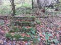
Foundation
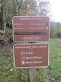
Trail head sign

