Black Mountain Crest Trail: Difference between revisions
m (Text replacement - "http://tehcc.org/clubwiki/" to "https://tehcc.org/clubwiki/") |
|||
| (17 intermediate revisions by 4 users not shown) | |||
| Line 1: | Line 1: | ||
{{Trail | |||
|Banner Image=File:Black Mountains Photos 07 Meadow between Winter Star and Gibbs.jpg | |||
|Trail Number=FS #179 | |||
|Trail System=SB6k | |||
|Park=Mount Mitchell State Park | |||
|Land Owner=Pisgah National Forest | |||
|Trail Marking=Orange Triangle | |||
|Trail Use=Hiking, Camping, Climbing | |||
|Trail Features=Vistas, Mountains | |||
|Difficulty Rating=Hard | |||
|Hike Time=8 hrs | |||
|Trail Distance=10.88 mi | |||
|Round Trip Distance=21.76 | |||
|Trail Type=In-and-Out | |||
|High Point=6,633 ft | |||
}}<!-- | |Low Point=3,052 ft | ||
|Elevation Gain=1,648 ft | |||
|Elevation Loss=5,139 ft | |||
|Elevation Change Direction=South-to-North | |||
-- | |Parking location=35.76679, -82.26493 | ||
|Trailhead location=35.76737, -82.26458 | |||
}} | |||
<!-- Convert to auto map once the other trail pages are created --> | |||
<display_map type="terrain" width="auto" height="600" gkml="https://tehcc.org/clubwiki/kml/Black_Mountains_Black_Mountain_Crest_Trail.kml, | |||
https://tehcc.org/clubwiki/kml/Black_Mountains_Celo_Knob_Trail.kml, | |||
https://tehcc.org/clubwiki/kml/Black_Mountains_Summit_Trail.kml, | |||
https://tehcc.org/clubwiki/kml/Black_Mountains_Big_Tom_Gap.kml, | |||
https://tehcc.org/clubwiki/kml/Black_Mountains_Colbert_Ridge_Trail.kml, | |||
https://tehcc.org/clubwiki/kml/Black_Mountains_Grace’s_Ladder.kml, | |||
https://tehcc.org/clubwiki/kml/Black_Mountains_Woody_Ridge_Trail.kml"> | |||
35.7649628007, -82.2650941309~Mount Mitchell (6,689 ft)~[[Image:Black_Mountains_Summits_01_Mount_Mitchell.jpg|150px]]~MarkerD.png | |||
35.7667944123, -82.2649348322~Mount Mitchell Parking~[[Image:Black_Mountains_Parking_01_Mount_Mitchell.jpg|150px]]~MarkerA.png | |||
35.7673711330, -82.2645821535~Trailhead at Mount Mitchell~[[Image:Black_Mountains_Trailhead_01_Mount_Mitchell.jpg|150px]]~MarkerT.png | |||
35.7738597100, -82.262404070~Rugged Trail Below Craig~[[Image:Black_Mountains_Photos_01_Rugged_Trail_Below_Craig.jpg|150px]]~MarkerB.png | |||
35.7773693000, -82.262131260~View From Mount Craig~[[Image:Black_Mountains_Photos_02_View_From_Mount_Craig.jpg|150px]]~MarkerB.png | |||
35.7774878750, -82.2620208723~Mount Craig (6,652 ft)~[[Image:Black_Mountains_Summits_02_Mount_Craig.jpg|150px]]~MarkerD.png | |||
35.7798993578, -82.2597768776~Big Tom (6,579 ft)~[[Image:Black_Mountains_Summits_03_Big_Tom.jpg|150px]]~MarkerD.png | |||
35.7814496100, -82.259641450~Ropes Help With Descent~[[Image:Black_Mountains_Photos_03_Ropes_Help_With_Descent.jpg|150px]]~MarkerB.png | |||
35.7853093940, -82.2582757417~Junction with Big Tom Gap Trail~[[Image:Black_Mountains_Junctions_01_Big_Tom_Gap_Trail.jpg|150px]]~MarkerT.png | |||
35.7894185134, -82.2558697310~Balsam Cone (6,601 ft)~[[Image:Black_Mountains_Summits_04_Balsam_Cone.jpg|150px]]~MarkerD.png | |||
35.7963145100, -82.2571981600~Cattail Peak False Summit Sign~[[Image:Black_Mountains_Poi_04_Cattail_Peak_False_Summit_Sign.jpg|150px]]~MarkerG.png | |||
35.8015289680, -82.2531327046~Potato Hill (6,472 ft)~[[Image:Black_Mountains_Summits_06_Potato_Hill.jpg|150px]]~MarkerD.png | |||
35.8015040300, -82.253131940~View From Potato Hill~[[Image:Black_Mountains_Photos_04_View_From_Potato_Hill.jpg|150px]]~MarkerB.png | |||
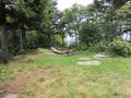
35.8124872344, -82.2521624167~Deep Gap Campsite~[[Image:Black_Mountains_Campsite_02_Deep_Gap_Campsite.jpg|150px]]~MarkerH.png | |||
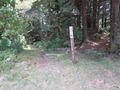
35.8122249094, -82.2522112843~Junction with Colbert Ridge Trail~[[Image:Black_Mountains_Junctions_02_Colbert_Ridge_Trail.jpg|150px]]~MarkerT.png | |||
35.8176817777, -82.2490050318~Winter Star Mountain (6,211 ft)~[[Image:Black_Mountains_Summits_08_Winter_Star.jpg|150px]]~MarkerD.png | |||
35.8177289000, -82.2491163400~Campsite 3~[[Image:Black_Mountains_Campsite_03.jpg|150px]]~MarkerH.png | |||
35.8192863500, -82.249137120~View Towards Roan Mountain~[[Image:Black_Mountains_Photos_05_View_Towards_Roan_Mountain.jpg|150px]]~MarkerB.png | |||
35.8198712600, -82.249334030~Trail Relocation~[[Image:Black_Mountains_Photos_06_Trail_Relocation.jpg|150px]]~MarkerB.png | |||
35.8269902200, -82.249583220~Meadow between Winter Star and Gibbs~[[Image:Black_Mountains_Photos_07_Meadow_between_Winter_Star_and_Gibbs.jpg|150px]]~MarkerB.png | |||
35.8405535992, -82.2479214831~Gibbs Mountain (6,247 ft)~[[Image:Black_Mountains_Summits_09_Gibbs_Mountain.jpg|150px]]~MarkerD.png | |||
35.8465440491, -82.2471993913~Junction with Woody Ridge Trail~[[Image:Black_Mountains_Junctions_03_Woody_Ridge_Trail.jpg|150px]]~MarkerT.png | |||
35.8505397800, -82.2483829500~Junction with Celo Knob Trail~[[Image:Black_Mountains_Junctions_05_Celo_Knob_Trail.jpg|150px]]~MarkerT.png | |||
35.8509559200, -82.249496650~View from Celo Knob meadow~[[Image:Black_Mountains_Photos_08_View_From_Celo_Knob_Meadow.jpg|150px]]~MarkerB.png | |||
35.8508984000, -82.249338800~View from Celo Knob meadow~[[Image:Black_Mountains_Photos_10_View_From_Celo_Knob_Meadow.jpg|150px]]~MarkerB.png | |||
35.8515752800, -82.250327170~View from Celo Knob meadow~[[Image:Black_Mountains_Photos_09_View_From_Celo_Knob_Meadow.jpg|150px]]~MarkerB.png | |||
35.8523799076, -82.2485352587~Celo Knob (6,331 ft)~[[Image:Black_Mountains_Summits_11_Celo_Knob.jpg|150px]]~MarkerD.png | |||
35.8478309994, -82.2473941258~Percys Peak (6,223 ft)~[[Image:Black_Mountains_Summits_10_Percys_Peak.jpg|150px]]~MarkerD.png | |||
35.8648024782, -82.2618514321~Campsite 1~[[Image:Black_Mountains_Campsite_01.jpg|150px]]~MarkerH.png | |||
35.8691567924, -82.2764822358~Dam~[[Image:Black_Mountains_Poi_01_Dam_On_Bowlens_Creek.jpg|150px]]~MarkerG.png | |||
35.8741984700, -82.2823612300~Trailhead at Bowlens Creek~[[Image:Black_Mountains_Trailhead_02_Bowlens_Creek.jpg|150px]]~MarkerT.png | |||
35.8764675286, -82.2837911661~Bowlens Creek Parking~[[Image:Black_Mountains_Parking_02_Bowlens_Creek.jpg|150px]]~MarkerA.png | |||
35.8776865469, -82.2862008209~Simmons Cemetery (alt parking)~[[Image:Black_Mountains_Cemetery_01_Simmons_Cemetery.jpg|150px]]~MarkerN.png | |||
35.8163250672, -82.2540967126~Deer Mountain (6,110 ft)~ ~MarkerD.png | |||
35.7653849168, -82.2648521643~Nature Center~ ~MarkerG.png | |||
35.7663570000, -82.2655260000~Museum and Gift Shop~ ~MarkerG.png | |||
35.7674330000, -82.2643890000~Picnic Area~ ~MarkerS.png | |||
35.8499616480, -82.2485592698~Junction with Graces Ladder~ ~MarkerT.png | |||
35.8491960000, -82.2477720000~Campsite 2~ ~MarkerH.png | |||
35.7983619941, -82.2564785814~Cattail Peak (6,580 ft)~ ~MarkerD.png | |||
</display_map> | |||
<br />__TOC__ | |||
== Trail Overview == | == Trail Overview == | ||
<!-- Enter a overview of the trail. What attracts you to this trail, points of interest, types of flowers, lakes, and peaks that you see along the way. --> | <!-- Enter a overview of the trail. What attracts you to this trail, points of interest, types of flowers, lakes, and peaks that you see along the way. --> | ||
One of the toughest trails in the Southeast. A rugged ridgeline hike that is a roller coaster of elevation changes which require lots of scrambling with hands, feet and sometimes ropes. The ridge is above 6000 feet in elevation the entire way except for the big drop at Deep Gap. Your reward is spectacular views the whole way with some of views (especially the northern part) being the best in all of North Carolina (IMHO). | One of the toughest trails in the Southeast. A rugged ridgeline hike that is a roller coaster of elevation changes which require lots of scrambling with hands, feet and sometimes ropes. The ridge is above 6000 feet in elevation the entire way except for the big drop at Deep Gap. Your reward is spectacular views the whole way with some of views (especially the northern part) being the best in all of North Carolina (IMHO). | ||
No matter how experienced a hiker you are, be prepared for a slower pace than what | No matter how experienced a hiker you are, be prepared for a slower pace than what you're used to. | ||
== How to get there == | == How to get there == | ||
<!-- Please enter detailed instruction on how to find the trail head. --> | <!-- Please enter detailed instruction on how to find the trail head. --> | ||
==== | ====Southern Trailhead (Mount Mitchell State Park)==== | ||
Trailhead is at the bottom of the Mount Mitchell summit parking lot by the picnic area. (35.7667944123, -82.2649348322). It is called "Deep Gap Trail". | Trailhead is at the bottom of the Mount Mitchell summit parking lot by the picnic area. (35.7667944123, -82.2649348322). It is called "Deep Gap Trail". | ||
Nice large parking area. Note that access is during park hours only and if the Blue Ridge Parkway is closed, you can't get to it. If you leave your car here overnight, you will need to notify a park ranger. | Nice large parking area. Note that access is during park hours only and if the Blue Ridge Parkway is closed, you can't get to it. If you leave your car here overnight, you will need to notify a park ranger. | ||
==== | ====Northern Trailhead (Bowlens Creek)==== | ||
The Bowlens Creek trailhead is just south of Burnsville NC just off of Bolens Creek Road (1109). Parking at this trailhead is limited and a little bit confusing. | The Bowlens Creek trailhead is just south of Burnsville NC just off of Bolens Creek Road (1109). Parking at this trailhead is limited and a little bit confusing. | ||
| Line 116: | Line 153: | ||
* Crest Trail does not go over the summit | * Crest Trail does not go over the summit | ||
* You must a take a steep, rugged side path to the top. | * You must a take a steep, rugged side path to the top. | ||
* | * Summit marked with a sign nailed to a tree just to the right of the geological marker | ||
* No views | * No views | ||
| Line 253: | Line 290: | ||
== Typical Conditions == | == Typical Conditions == | ||
<!-- Typical conditions throughout the year of what to expect on the trail. Rocky, muddy, sandy, flowers, lots of downed trees? --> | <!-- Typical conditions throughout the year of what to expect on the trail. Rocky, muddy, sandy, flowers, lots of downed trees? --> | ||
A difficult high elevation ridgeline hike. Be prepared to have a slower pace than what | A difficult high elevation ridgeline hike. Be prepared to have a slower pace than what you're used to. Take lots of water due to being more exposed to sun and wind. Weather can change rapidly. The Black Mountains are notorious for being cloud covered most of the time and thunderstorms in the afternoon all summer. Be prepared! | ||
==Fees, Permits, etc. == | ==Fees, Permits, etc. == | ||
| Line 264: | Line 301: | ||
== Misc. Information == | == Misc. Information == | ||
<!-- Enter any additional information that doesn't fit an any other fields. Does this trail require any permits for overnight? parking? --> | <!-- Enter any additional information that doesn't fit an any other fields. Does this trail require any permits for overnight? parking? --> | ||
If you hike this trail as a shuttle, the drive time between the Bowlens Creek trailhead and the Mount Mitchell parking lot is about an hour via State Route 80 and the Blue Ridge Parkway. | |||
A good day hike that I recommend is starting at the Bowlens Creek trailhead and hike to the top of Celo Knob and back. It's about 9 miles round trip. The trail up from Bowens Creek is a "normal" trail with no technical areas or rock scrambles but it is about 4 miles of unrelenting uphill the entire way. Your reward is the stunning views from the meadow below the summit of Celo Knob which are IMHO some of the best views in the entire state. The trailhead is only about 1.5 hours from Kingsport. | |||
== Photos == | == Photos == | ||
<gallery> | <gallery> | ||
<!-- Place any pictures from this trail below. Add a picture by typing Image:imagename.extension --> | <!-- Place any pictures from this trail below. Add a picture by typing Image:imagename.extension --> | ||
Image:Black_Mountains_Summits_01_Mount_Mitchell.jpg|Summit of Mount Mitchell | |||
Image:Black_Mountains_Parking_01_Mount_Mitchell.jpg|Mount Mitchell Parking Lot | |||
Image:Black_Mountains_Trailhead_01_Mount_Mitchell.jpg|Trail begins at the picnic area | |||
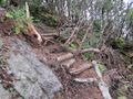
Image:Black_Mountains_Photos_01_Rugged_Trail_Below_Craig.jpg|It doesn't take long before the trail starts to get rough | |||
Image:Black_Mountains_Photos_02_View_From_Mount_Craig.jpg|Stunning views from Mount Craig | |||
Image:Black_Mountains_Summits_02_Mount_Craig.jpg|Mount Craig Benchmark | |||
Image:Black_Mountains_Summits_03_Big_Tom.jpg|Big Tom Benchmark | |||
Image:Black_Mountains_Photos_03_Ropes_Help_With_Descent.jpg|Some parts are so steep, you needs ropes to help | |||
Image:Black_Mountains_Junctions_01_Big_Tom_Gap_Trail.jpg|Big Top Gap Trail | |||
Image:Black_Mountains_Summits_04_Balsam_Cone.jpg|Nice views from Balsam Cone | |||
Image:Black_Mountains_Poi_04_Cattail_Peak_False_Summit_Sign.jpg|False summit sign. This is NOT the summit of Cattail Peak! | |||
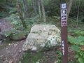
Image:Black_Mountains_Summits_06_Potato_Hill.jpg|Nicely made summit sign | |||
Image:Black_Mountains_Photos_04_View_From_Potato_Hill.jpg|Views like this off and on for entire trail | |||
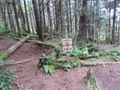
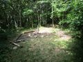
Image:Black_Mountains_Campsite_02_Deep_Gap_Campsite.jpg|Large camp area at Deep Gap. | |||
Image:Black_Mountains_Junctions_02_Colbert_Ridge_Trail.jpg|Colbert Ridge Trail | |||
Image:Black_Mountains_Summits_08_Winter_Star.jpg|Winter Star Benchmark | |||
Image:Black_Mountains_Campsite_03.jpg|Views from the campsite on Winter Star Mountain | |||
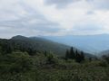
Image:Black_Mountains_Photos_05_View_Towards_Roan_Mountain.jpg|The views just don't stop. You can see the Roan Highlands in the distance. | |||
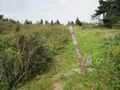
Image:Black_Mountains_Photos_06_Trail_Relocation.jpg|nchighpeaks.org rerouted the trail in 2012 to avoid the notorious Jake's Step rock scramble. | |||
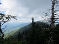
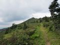
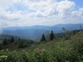
Image:Black_Mountains_Photos_07_Meadow_between_Winter_Star_and_Gibbs.jpg|While you’re taking a beating between Winter Star Mountain and Gibbs Mountain, you can pause to catch your breath and get stunning views like this. | |||
Image:Black_Mountains_Summits_09_Gibbs_Mountain.jpg|From here the trail finally calms down and is not that technical. The views really start opening up the rest of the way to Celo Knob. | |||
Image:Black_Mountains_Junctions_03_Woody_Ridge_Trail.jpg|Woody Ridge Trail | |||
Image:Black_Mountains_Junctions_05_Celo_Knob_Trail.jpg|Short but rough side trail to the summit Celo Knob | |||
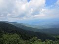
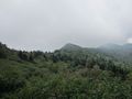
Image:Black_Mountains_Photos_08_View_From_Celo_Knob_Meadow.jpg|It doesn’t get much better than this. Looking at the entire Black Mountain range. | |||
Image:Black_Mountains_Photos_09_View_From_Celo_Knob_Meadow.jpg|Looking across valley to Big Butt Mountain | |||
Image:Black_Mountains_Photos_10_View_From_Celo_Knob_Meadow.jpg|Clouds suddenly overtake the ridge. The weather can be pretty wild up here | |||
Image:Black_Mountains_Summits_11_Celo_Knob.jpg|No views from the summit of Celo Knob | |||
Image:Black_Mountains_Summits_10_Percys_Peak.jpg|Percy's Peak. Getting ready to say by by to the ridgeline. | |||
Image:Black_Mountains_Campsite_01.jpg|Small campsite on the way down | |||
Image:Black_Mountains_Poi_01_Dam_On_Bowlens_Creek.jpg|Unknown dam on Bowlens Creek. | |||
Image:Black_Mountains_Trailhead_02_Bowlens_Creek.jpg|The trailhead. Not too much further | |||
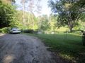
Image:Black_Mountains_Parking_02_Bowlens_Creek.jpg|Bowlens Creek parking. Only room for one car! | |||
Image:Black_Mountains_Cemetery_01_Simmons_Cemetery.jpg|Alternative and larger parking at a cemetery on Bowlens Creek Road | |||
<!-- Do not remove the end gallery code.--> | <!-- Do not remove the end gallery code.--> | ||
</gallery> | </gallery> | ||
Latest revision as of 12:12, 7 January 2023
| Black Mountain Crest Trail (log in to submit report) | |
|---|---|

| |
| Trail Number | FS #179 |
| Trail System | SB6k |
| Park | Mount Mitchell State Park |
| Land Owner | Pisgah National Forest |
| Located | Burnsville, North CarolinaLocation inherited from associated park |
| Trail Marking | Orange Triangle |
| Trail UseThings allowed to do on or near the trail |
|
| FeaturesThings to see on or near the trail |
|
| Difficulty Rating | Hard |
| Hiking TimeTime from car and back. Includes any time hiking to access this trail. | 8 hrs0.5 Days <br />480 Min <br /> round trip |
| Distance: | 10.88 mi17.51 km <br /> trailStrict non-repeating trail length / 21.7621.76 mi <br />35.019 km <br /> round tripTypical or shortest length from the car, hike the trail, and return to car |
| Trail Type | In-and-Out |
| Low / High Point | 3,052 ft1,017.333 Yards <br />930.25 Meters <br /> / 6,633 ft2,211 Yards <br />2,021.738 Meters <br /> |
| Elev. Gain/LossSee link for details of calculation. Gain/Loss is direction dependent. | 1,648 ft502.31 Meters <br /> / (5,139 ft1,566.367 Meters <br />) – South-to-North |
| Trip ReportsFrom user "hiked it" submissions<br />Recent is within last 90 days | 1 logged hikes (0 recent) |
| NearbyWithin 5 mi<br />Click link to view list | 3 trails / 13.3 mi of trail |
| Parking | 35° 46' 0.44" N, 82° 15' 53.75" W Map |
| Trailhead | 35° 46' 2.53" N, 82° 15' 52.49" W Map |
|
| |
| Show In Google Maps | |
Trail Overview[edit]
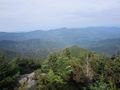
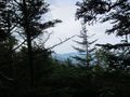
One of the toughest trails in the Southeast. A rugged ridgeline hike that is a roller coaster of elevation changes which require lots of scrambling with hands, feet and sometimes ropes. The ridge is above 6000 feet in elevation the entire way except for the big drop at Deep Gap. Your reward is spectacular views the whole way with some of views (especially the northern part) being the best in all of North Carolina (IMHO).
No matter how experienced a hiker you are, be prepared for a slower pace than what you're used to.
How to get there[edit]
Southern Trailhead (Mount Mitchell State Park)[edit]
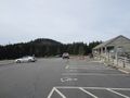
Trailhead is at the bottom of the Mount Mitchell summit parking lot by the picnic area. (35.7667944123, -82.2649348322). It is called "Deep Gap Trail".
Nice large parking area. Note that access is during park hours only and if the Blue Ridge Parkway is closed, you can't get to it. If you leave your car here overnight, you will need to notify a park ranger.
Northern Trailhead (Bowlens Creek)[edit]
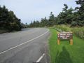
The Bowlens Creek trailhead is just south of Burnsville NC just off of Bolens Creek Road (1109). Parking at this trailhead is limited and a little bit confusing.
Turn down Watershed Road from Bolens Creek Road and to your right is a small parking area (35.8764675286, -82.2837911661) that has room for a grand total of one car. If it's taken, there is a small cemetery just past that on Bolens Creek Road that has room to park (35.8776865469, -82.2862008209). You can just walk back to Watershed Road until you reach the trailhead.
[edit]
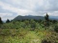
The Crest Trail goes over or near 10 mountains that are over 6,000 feet in elevation. Six of those peaks are on the South Beyond 6000 (SB6K) challenge list can be bagged along this route.
In order of encounter from the Mount Mitchell Parking Lot
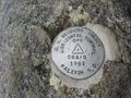
Mt. Craig (6,647 feet)
- SB6k Peak
- Crest Trail goes over the summit
- Has benchmark and plaque to mark summit
- Has views
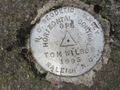
Big Tom (6,579 feet)
- Crest Trail goes over the summit
- Has benchmark and plaque to mark summit
- No views
Balsam Cone (6,611 feet)
- SB6k Peak
- Crest Trail goes over the summit
- No benchmark or summit markings
- Has views
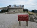
Cattail Peak (6,580 feet)
- SB6k Peak
- Crest Trail does not go over summit and requires a .2 mile bushwhack
- Has benchmark to mark summit
- Has views
- A false Cattail Peak summit sign is directly on the Crest Trail about .5 miles from the true summit for some reason. For years this has been fooling peak baggers into thinking they made the summit.
- After the sign, right before the trail drops below the ridgeline towards Potato Hill is a small yellow survey marker on the ground. Start your bushwhack here to the obvious high point that is the true summit.
Potato Hill (6,475 feet)
- NOTE Potato Hill used to be the peak you had to bag for the SB6K list but it was changed to Cattail Peak recently.
- Crest Trail is right off summit
- No benchmark but has wooden sign to mark summit
- Has views
Deer Mountain (6,110 feet)
- Crest Trail does not go over summit and requires a bushwhack
- No benchmark or markings to indicate summit
- No views
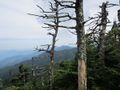
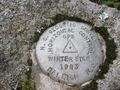
Winter Star Mountain (6,212 feet)
- SB6k Peak
- Crest Trail passes by just off of the summit
- Has benchmark and a nice camping site
- Has views
Gibbs Mountain (6,224 feet)
- SB6k Peak
- Crest Trail does not go over summit and requires a short bushwhack
- No benchmark to mark summit
- No views
Percy’s Peak (6,331 feet)
- Crest Trail does not go over summit and requires a short bushwhack
- No benchmark to mark summit
- No views
Celo Knob (6,327 feet)
- SB6k Peak
- Crest Trail does not go over the summit
- You must a take a steep, rugged side path to the top.
- Summit marked with a sign nailed to a tree just to the right of the geological marker
- No views
Route Description[edit]
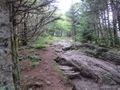
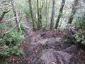
The southern half of the trail from Mount Mitchell to Deep Gap is in Mount Mitchell State Park and maintained by the park maintenance crew. This part is very rugged, rocky with lots of roots on the trail. A few parts require the use of ropes due to the steepness.
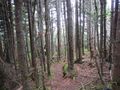
http://nchighpeaks.org/ maintains the northern part of the trail from Deep Gap to Bowlens Creek. They have done a few reroutes around some of the more treacherous sections in recent times plus they did a major clean-up in 2014. It is well maintained but much of this trail's tough reputation resides in this section, especially the part between Winter Star Mountain and Gibbs Mountain so be prepared for a tough slow pace. Beyond Gibbs, the trail becomes a little more "normal" i.e. no technical sections.
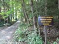
While in the state park, the trail is referred to as the Deep Gap Trail and is blazed with orange triangles. Camping is not allowed except at the Deep Gap campsite.
The northern part outside the state park is referred to as the Crest Trail and blazes are orange, yellow and/or white. No restrictions on camping.
| Miles | Black Mountain Crest Trail | Miles | Elevation |
|---|---|---|---|
| 0.0 | Mount Mitchell Trailhead | 10.8 | 6582 |
| 0.8 | Mount Craig | 10.0 | 6652 |
| 1.0 | Big Tom | 9.8 | 6579 |
| 1.4 | Junction with Big Tom Gap Trail | 9.4 | 6268 |
| 1.7 | Balsam Cone | 9.1 | 6601 |
| 2.2 | Cattail Peak False Summit Sign | 8.6 | 6530 |
| 2.3 | Yellow Marker for Cattail bushwhack | 8.5 | 6535 |
| 2.7 | Potato Hill | 8.1 | 6472 |
| 3.5 | Deep Gap | 7.3 | 5743 |
| 3.6 | Junction with Colbert Ridge Trail | 7.2 | 5747 |
| 4.1 | Winter Star Mountain | 6.7 | 6211 |
| 5.9 | Gibbs Mountain | 4.9 | 6108 |
| 6.3 | Junction with Woody Ridge Trail | 4.5 | 6141 |
| 6.4 | Percy’s Peak | 4.4 | 6150 |
| 6.6 | Junction with Graces Ladder | 4.2 | 6110 |
| 6.7 | Junction with Celo Knob Trail | 4.1 | 6153 |
| 8.6 | Campsite 1 | 2.2 | 4846 |
| 10.0 | Dam | 0.8 | 3521 |
| 10.8 | Bowlens Creek Trailhead | 0.0 | 3058 |
Typical Conditions[edit]
A difficult high elevation ridgeline hike. Be prepared to have a slower pace than what you're used to. Take lots of water due to being more exposed to sun and wind. Weather can change rapidly. The Black Mountains are notorious for being cloud covered most of the time and thunderstorms in the afternoon all summer. Be prepared!
Fees, Permits, etc.[edit]
No fees or permits required. No bikes, ATV, or horses allowed on this trail.
After the Hike[edit]
Misc. Information[edit]
If you hike this trail as a shuttle, the drive time between the Bowlens Creek trailhead and the Mount Mitchell parking lot is about an hour via State Route 80 and the Blue Ridge Parkway.
A good day hike that I recommend is starting at the Bowlens Creek trailhead and hike to the top of Celo Knob and back. It's about 9 miles round trip. The trail up from Bowens Creek is a "normal" trail with no technical areas or rock scrambles but it is about 4 miles of unrelenting uphill the entire way. Your reward is the stunning views from the meadow below the summit of Celo Knob which are IMHO some of the best views in the entire state. The trailhead is only about 1.5 hours from Kingsport.
Photos[edit]
Summit of Mount Mitchell
Mount Mitchell Parking Lot
Trail begins at the picnic area
It doesn't take long before the trail starts to get rough
Stunning views from Mount Craig
Mount Craig Benchmark
Big Tom Benchmark
Some parts are so steep, you needs ropes to help
Big Top Gap Trail
Nice views from Balsam Cone
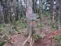
False summit sign. This is NOT the summit of Cattail Peak!
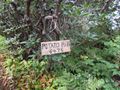
Nicely made summit sign
Views like this off and on for entire trail
Large camp area at Deep Gap.
Colbert Ridge Trail
Winter Star Benchmark
Views from the campsite on Winter Star Mountain
The views just don't stop. You can see the Roan Highlands in the distance.
nchighpeaks.org rerouted the trail in 2012 to avoid the notorious Jake's Step rock scramble.
While you’re taking a beating between Winter Star Mountain and Gibbs Mountain, you can pause to catch your breath and get stunning views like this.
From here the trail finally calms down and is not that technical. The views really start opening up the rest of the way to Celo Knob.
Woody Ridge Trail
Short but rough side trail to the summit Celo Knob
It doesn’t get much better than this. Looking at the entire Black Mountain range.
Looking across valley to Big Butt Mountain
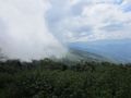
Clouds suddenly overtake the ridge. The weather can be pretty wild up here
No views from the summit of Celo Knob
Percy's Peak. Getting ready to say by by to the ridgeline.
Small campsite on the way down
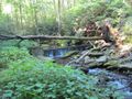
Unknown dam on Bowlens Creek.
The trailhead. Not too much further
Bowlens Creek parking. Only room for one car!
Alternative and larger parking at a cemetery on Bowlens Creek Road


