The trail bypasses the farm and most of the gates.
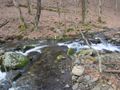
First part of trail is in cow field before entering woods at a farm gate. The trail is blazed white vinyl and follows the Left Prong Creek.
Trail is good condition and well blazed. Blazes nailed to trees. Not hard to follow. A little narrow in places.
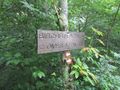
No permit or fee. The nature area closes at dusk. The trail officially says no mountain bikes or horses.
Loading map...
{"type":"TERRAIN","minzoom":false,"maxzoom":false,"types":["ROADMAP","SATELLITE","HYBRID","TERRAIN"],"mappingservice":"googlemaps3","width":"auto","height":"600px","centre":false,"title":"","label":"","icon":"","lines":[],"polygons":[],"circles":[],"rectangles":[],"copycoords":false,"static":false,"visitedicon":"","wmsoverlay":false,"zoom":false,"layers":[],"controls":["pan","zoom","type","scale","streetview","rotate"],"zoomstyle":"DEFAULT","typestyle":"DEFAULT","autoinfowindows":false,"resizable":false,"kmlrezoom":false,"poi":true,"cluster":false,"clustergridsize":60,"clustermaxzoom":20,"clusterzoomonclick":true,"clusteraveragecenter":true,"clusterminsize":2,"imageoverlays":[],"kml":[],"gkml":["https://tehcc.org/clubwiki/kml/HCCSNA_Birchfield_Trail.kml","https://tehcc.org/clubwiki/kml/HCCSNA_Overmountain_Shelter_Trail.kml","https://tehcc.org/clubwiki/kml/HCCSNA_Overmountain_Victory_Trail.kml","https://tehcc.org/clubwiki/kml/HCCSNA_Shell_Hollow_Trail.kml"],"searchmarkers":"","fullscreen":false,"scrollwheelzoom":false,"locations":[{"text":"\u003Cb\u003E\u003Cdiv class=\"mw-parser-output\"\u003E\u003Cp\u003EView into Hampton Cove\n\u003C/p\u003E\u003C/div\u003E\u003C/b\u003E\u003Cdiv class=\"mw-parser-output\"\u003E\u003Cp\u003E\u003Ca href=\"/wiki/File:HCCSNA_View_Into_Hampton_Cove.jpg\" class=\"image\"\u003E\u003Cimg alt=\"HCCSNA View Into Hampton Cove.jpg\" src=\"/clubwiki/images/thumb/HCCSNA_View_Into_Hampton_Cove.jpg/150px-HCCSNA_View_Into_Hampton_Cove.jpg\" decoding=\"async\" width=\"150\" height=\"113\" srcset=\"/clubwiki/images/thumb/HCCSNA_View_Into_Hampton_Cove.jpg/225px-HCCSNA_View_Into_Hampton_Cove.jpg 1.5x, /clubwiki/images/thumb/HCCSNA_View_Into_Hampton_Cove.jpg/300px-HCCSNA_View_Into_Hampton_Cove.jpg 2x\" data-file-width=\"1200\" data-file-height=\"900\" /\u003E\u003C/a\u003E\n\u003C/p\u003E\u003C/div\u003E","title":"View into Hampton Cove\n","link":"","lat":36.13413757869999898275636951439082622528076171875,"lon":-82.0405528417999931889426079578697681427001953125,"icon":"/clubwiki/images/MarkerB.png"},{"text":"\u003Cdiv class=\"mw-parser-output\"\u003E\u003Cp\u003EHampton Cove Parking\n\u003C/p\u003E\u003C/div\u003E","title":"Hampton Cove Parking\n","link":"","lat":36.15231279230000183133597602136433124542236328125,"lon":-82.0556224481999976205770508386194705963134765625,"icon":"/clubwiki/images/MarkerA.png"},{"text":"\u003Cdiv class=\"mw-parser-output\"\u003E\u003Cp\u003ERoaring Creek Parking\n\u003C/p\u003E\u003C/div\u003E","title":"Roaring Creek Parking\n","link":"","lat":36.1170074500000026773705030791461467742919921875,"lon":-82.0489487139000033266711398027837276458740234375,"icon":"/clubwiki/images/MarkerA.png"},{"text":"\u003Cb\u003E\u003Cdiv class=\"mw-parser-output\"\u003E\u003Cp\u003EOvermountain Barn\n\u003C/p\u003E\u003C/div\u003E\u003C/b\u003E\u003Cdiv class=\"mw-parser-output\"\u003E\u003Cp\u003E\u003Ca href=\"/wiki/File:HCCSNA_Overmountain_Barn_From_AT.jpg\" class=\"image\"\u003E\u003Cimg alt=\"HCCSNA Overmountain Barn From AT.jpg\" src=\"/clubwiki/images/thumb/HCCSNA_Overmountain_Barn_From_AT.jpg/150px-HCCSNA_Overmountain_Barn_From_AT.jpg\" decoding=\"async\" width=\"150\" height=\"113\" srcset=\"/clubwiki/images/thumb/HCCSNA_Overmountain_Barn_From_AT.jpg/225px-HCCSNA_Overmountain_Barn_From_AT.jpg 1.5x, /clubwiki/images/thumb/HCCSNA_Overmountain_Barn_From_AT.jpg/300px-HCCSNA_Overmountain_Barn_From_AT.jpg 2x\" data-file-width=\"1200\" data-file-height=\"900\" /\u003E\u003C/a\u003E\n\u003C/p\u003E\u003C/div\u003E","title":"Overmountain Barn\n","link":"","lat":36.123615000000000918589648790657520294189453125,"lon":-82.054214000000001760781742632389068603515625,"icon":"/clubwiki/images/MarkerF.png"},{"text":"\u003Cdiv class=\"mw-parser-output\"\u003E\u003Cp\u003EShell Cemetery\n\u003C/p\u003E\u003C/div\u003E","title":"Shell Cemetery\n","link":"","lat":36.14895009939999681591871194541454315185546875,"lon":-82.0430267086999975845174049027264118194580078125,"icon":"/clubwiki/images/MarkerN.png"},{"text":"\u003Cb\u003E\u003Cdiv class=\"mw-parser-output\"\u003E\u003Cp\u003ECreek Crossing\n\u003C/p\u003E\u003C/div\u003E\u003C/b\u003E\u003Cdiv class=\"mw-parser-output\"\u003E\u003Cp\u003E\u003Ca href=\"/wiki/File:HCCSNA_Birchfield_Creek_Crossing.jpg\" class=\"image\"\u003E\u003Cimg alt=\"HCCSNA Birchfield Creek Crossing.jpg\" src=\"/clubwiki/images/thumb/HCCSNA_Birchfield_Creek_Crossing.jpg/150px-HCCSNA_Birchfield_Creek_Crossing.jpg\" decoding=\"async\" width=\"150\" height=\"113\" srcset=\"/clubwiki/images/thumb/HCCSNA_Birchfield_Creek_Crossing.jpg/225px-HCCSNA_Birchfield_Creek_Crossing.jpg 1.5x, /clubwiki/images/thumb/HCCSNA_Birchfield_Creek_Crossing.jpg/300px-HCCSNA_Birchfield_Creek_Crossing.jpg 2x\" data-file-width=\"1200\" data-file-height=\"900\" /\u003E\u003C/a\u003E\n\u003C/p\u003E\u003C/div\u003E","title":"Creek Crossing\n","link":"","lat":36.14044095599999906198718235827982425689697265625,"lon":-82.0468414829000067811648477800190448760986328125,"icon":"/clubwiki/images/MarkerJ.png"},{"text":"\u003Cb\u003E\u003Cdiv class=\"mw-parser-output\"\u003E\u003Cp\u003EFarm Gate\n\u003C/p\u003E\u003C/div\u003E\u003C/b\u003E\u003Cdiv class=\"mw-parser-output\"\u003E\u003Cp\u003E\u003Ca href=\"/wiki/File:HCCSNA_Farm_Gate_01.jpg\" class=\"image\"\u003E\u003Cimg alt=\"HCCSNA Farm Gate 01.jpg\" src=\"/clubwiki/images/thumb/HCCSNA_Farm_Gate_01.jpg/150px-HCCSNA_Farm_Gate_01.jpg\" decoding=\"async\" width=\"150\" height=\"113\" srcset=\"/clubwiki/images/thumb/HCCSNA_Farm_Gate_01.jpg/225px-HCCSNA_Farm_Gate_01.jpg 1.5x, /clubwiki/images/thumb/HCCSNA_Farm_Gate_01.jpg/300px-HCCSNA_Farm_Gate_01.jpg 2x\" data-file-width=\"1200\" data-file-height=\"900\" /\u003E\u003C/a\u003E\n\u003C/p\u003E\u003C/div\u003E","title":"Farm Gate\n","link":"","lat":36.14105681000000203084709937684237957000732421875,"lon":-82.04615334999999731735442765057086944580078125,"icon":"/clubwiki/images/MarkerG.png"},{"text":"\u003Cb\u003E\u003Cdiv class=\"mw-parser-output\"\u003E\u003Cp\u003EFarm Gate\n\u003C/p\u003E\u003C/div\u003E\u003C/b\u003E\u003Cdiv class=\"mw-parser-output\"\u003E\u003Cp\u003E\u003Ca href=\"/wiki/File:HCCSNA_Farm_Gate_02.jpg\" class=\"image\"\u003E\u003Cimg alt=\"HCCSNA Farm Gate 02.jpg\" src=\"/clubwiki/images/thumb/HCCSNA_Farm_Gate_02.jpg/150px-HCCSNA_Farm_Gate_02.jpg\" decoding=\"async\" width=\"150\" height=\"113\" srcset=\"/clubwiki/images/thumb/HCCSNA_Farm_Gate_02.jpg/225px-HCCSNA_Farm_Gate_02.jpg 1.5x, /clubwiki/images/thumb/HCCSNA_Farm_Gate_02.jpg/300px-HCCSNA_Farm_Gate_02.jpg 2x\" data-file-width=\"1200\" data-file-height=\"900\" /\u003E\u003C/a\u003E\n\u003C/p\u003E\u003C/div\u003E","title":"Farm Gate\n","link":"","lat":36.1379704200000020364313968457281589508056640625,"lon":-82.0443995199999989154093782417476177215576171875,"icon":"/clubwiki/images/MarkerG.png"},{"text":"\u003Cb\u003E\u003Cdiv class=\"mw-parser-output\"\u003E\u003Cp\u003ETrailhead Roaring Creek\n\u003C/p\u003E\u003C/div\u003E\u003C/b\u003E\u003Cdiv class=\"mw-parser-output\"\u003E\u003Cp\u003E\u003Ca href=\"/wiki/File:HCCSNA_Trailhead_Roaring_Creek.jpg\" class=\"image\"\u003E\u003Cimg alt=\"HCCSNA Trailhead Roaring Creek.jpg\" src=\"/clubwiki/images/thumb/HCCSNA_Trailhead_Roaring_Creek.jpg/150px-HCCSNA_Trailhead_Roaring_Creek.jpg\" decoding=\"async\" width=\"150\" height=\"113\" srcset=\"/clubwiki/images/thumb/HCCSNA_Trailhead_Roaring_Creek.jpg/225px-HCCSNA_Trailhead_Roaring_Creek.jpg 1.5x, /clubwiki/images/thumb/HCCSNA_Trailhead_Roaring_Creek.jpg/300px-HCCSNA_Trailhead_Roaring_Creek.jpg 2x\" data-file-width=\"1200\" data-file-height=\"900\" /\u003E\u003C/a\u003E\n\u003C/p\u003E\u003C/div\u003E","title":"Trailhead Roaring Creek\n","link":"","lat":36.11689075230000156579990289174020290374755859375,"lon":-82.0486987935999962928690365515649318695068359375,"icon":"/clubwiki/images/MarkerT.png"},{"text":"\u003Cb\u003E\u003Cdiv class=\"mw-parser-output\"\u003E\u003Cp\u003ETrail Junction Shelter Trail\n\u003C/p\u003E\u003C/div\u003E\u003C/b\u003E\u003Cdiv class=\"mw-parser-output\"\u003E\u003Cp\u003E\u003Ca href=\"/wiki/File:HCCSNA_Junctions_Shelter_Trail.jpg\" class=\"image\"\u003E\u003Cimg alt=\"HCCSNA Junctions Shelter Trail.jpg\" src=\"/clubwiki/images/thumb/HCCSNA_Junctions_Shelter_Trail.jpg/150px-HCCSNA_Junctions_Shelter_Trail.jpg\" decoding=\"async\" width=\"150\" height=\"113\" srcset=\"/clubwiki/images/thumb/HCCSNA_Junctions_Shelter_Trail.jpg/225px-HCCSNA_Junctions_Shelter_Trail.jpg 1.5x, /clubwiki/images/thumb/HCCSNA_Junctions_Shelter_Trail.jpg/300px-HCCSNA_Junctions_Shelter_Trail.jpg 2x\" data-file-width=\"1200\" data-file-height=\"900\" /\u003E\u003C/a\u003E\n\u003C/p\u003E\u003C/div\u003E","title":"Trail Junction Shelter Trail\n","link":"","lat":36.1255151268999981084562023170292377471923828125,"lon":-82.05124094789999844579142518341541290283203125,"icon":"/clubwiki/images/MarkerT.png"},{"text":"\u003Cb\u003E\u003Cdiv class=\"mw-parser-output\"\u003E\u003Cp\u003EYellow Mountain Gap Junction\n\u003C/p\u003E\u003C/div\u003E\u003C/b\u003E\u003Cdiv class=\"mw-parser-output\"\u003E\u003Cp\u003E\u003Ca href=\"/wiki/File:HCCSNA_Junctions_Yellow_Mountain_Gap.jpg\" class=\"image\"\u003E\u003Cimg alt=\"HCCSNA Junctions Yellow Mountain Gap.jpg\" src=\"/clubwiki/images/thumb/HCCSNA_Junctions_Yellow_Mountain_Gap.jpg/150px-HCCSNA_Junctions_Yellow_Mountain_Gap.jpg\" decoding=\"async\" width=\"150\" height=\"113\" srcset=\"/clubwiki/images/thumb/HCCSNA_Junctions_Yellow_Mountain_Gap.jpg/225px-HCCSNA_Junctions_Yellow_Mountain_Gap.jpg 1.5x, /clubwiki/images/thumb/HCCSNA_Junctions_Yellow_Mountain_Gap.jpg/300px-HCCSNA_Junctions_Yellow_Mountain_Gap.jpg 2x\" data-file-width=\"1200\" data-file-height=\"900\" /\u003E\u003C/a\u003E\n\u003C/p\u003E\u003C/div\u003E","title":"Yellow Mountain Gap Junction\n","link":"","lat":36.12575879229999742392465122975409030914306640625,"lon":-82.05145379169999841906246729195117950439453125,"icon":"/clubwiki/images/MarkerT.png"},{"text":"\u003Cb\u003E\u003Cdiv class=\"mw-parser-output\"\u003E\u003Cp\u003EJunction Birchfield Trail North\n\u003C/p\u003E\u003C/div\u003E\u003C/b\u003E\u003Cdiv class=\"mw-parser-output\"\u003E\u003Cp\u003E\u003Ca href=\"/wiki/File:HCCSNA_Junctions_North.jpg\" class=\"image\"\u003E\u003Cimg alt=\"HCCSNA Junctions North.jpg\" src=\"/clubwiki/images/thumb/HCCSNA_Junctions_North.jpg/150px-HCCSNA_Junctions_North.jpg\" decoding=\"async\" width=\"150\" height=\"113\" srcset=\"/clubwiki/images/thumb/HCCSNA_Junctions_North.jpg/225px-HCCSNA_Junctions_North.jpg 1.5x, /clubwiki/images/thumb/HCCSNA_Junctions_North.jpg/300px-HCCSNA_Junctions_North.jpg 2x\" data-file-width=\"1200\" data-file-height=\"900\" /\u003E\u003C/a\u003E\n\u003C/p\u003E\u003C/div\u003E","title":"Junction Birchfield Trail North\n","link":"","lat":36.1353754626999972288103890605270862579345703125,"lon":-82.04251037410000435556867159903049468994140625,"icon":"/clubwiki/images/MarkerT.png"},{"text":"\u003Cb\u003E\u003Cdiv class=\"mw-parser-output\"\u003E\u003Cp\u003EJunction Birchfield Trail South\n\u003C/p\u003E\u003C/div\u003E\u003C/b\u003E\u003Cdiv class=\"mw-parser-output\"\u003E\u003Cp\u003E\u003Ca href=\"/wiki/File:HCCSNA_Junctions_South.jpg\" class=\"image\"\u003E\u003Cimg alt=\"HCCSNA Junctions South.jpg\" src=\"/clubwiki/images/thumb/HCCSNA_Junctions_South.jpg/150px-HCCSNA_Junctions_South.jpg\" decoding=\"async\" width=\"150\" height=\"113\" srcset=\"/clubwiki/images/thumb/HCCSNA_Junctions_South.jpg/225px-HCCSNA_Junctions_South.jpg 1.5x, /clubwiki/images/thumb/HCCSNA_Junctions_South.jpg/300px-HCCSNA_Junctions_South.jpg 2x\" data-file-width=\"1200\" data-file-height=\"900\" /\u003E\u003C/a\u003E\n\u003C/p\u003E\u003C/div\u003E","title":"Junction Birchfield Trail South\n","link":"","lat":36.14698840129999979353669914416968822479248046875,"lon":-82.0495906876000020702122128568589687347412109375,"icon":"/clubwiki/images/MarkerT.png"}]}