|
|
| Line 2: |
Line 2: |
| {{Infobox Trail | | {{Infobox Trail |
| | Image Name = BMP Big Oak Trail.JPG | | | Image Name = BMP Big Oak Trail.JPG |
| | | Trail Number = |
| | Park = Bays Mountain Park | | | Park = Bays Mountain Park |
| | City = Kingsport | | | City = Kingsport |
| Line 9: |
Line 10: |
| | Difficulty Rating = Medium | | | Difficulty Rating = Medium |
| | Hike Time = 30 Min | | | Hike Time = 30 Min |
| | Round Trip Distance = 2.2 Mi | | | Round Trip Distance = 3.08 Mi |
| | Trail Distance = 1.1 Mi | | | Trail Distance = 1.1 Mi |
| | Trail Type = Segment | | | Trail Type = Segment |
| Line 23: |
Line 24: |
| == Trail Overview == | | == Trail Overview == |
| <!-- Enter a overview of the trail. What attracts you to this trail, points of interest, types of flowers, lakes, and peaks that you see along the way. --> | | <!-- Enter a overview of the trail. What attracts you to this trail, points of interest, types of flowers, lakes, and peaks that you see along the way. --> |
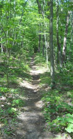
| Located in [[Bays Mountain Park]]. Parallel alternative for [[BMP Azalea Trail|Azalea Trail]] up to the Antennas - or return loop option. Nice hike or ride through forest of maples, tulip poplars, ferns, oaks, and other hardwoods. | | Located in [[Bays Mountain Park]]. Parallel alternative for [[Azalea|Azalea]] up to the Antennas - or return loop option. Nice hike or ride through forest of maples, tulip poplars, ferns, oaks, and other hardwoods. |
|
| |
|
| == How to get there == | | == How to get there == |
| Line 32: |
Line 33: |
| <!-- Detailed description of the route. Is there any side trails that are worth traveling? --> | | <!-- Detailed description of the route. Is there any side trails that are worth traveling? --> |
| The path runs parallel and across the hollow from Azalea Trail. Continue up to Bays Mountain Road and over to the Antennas for an overlook of downtown Kingsport. | | The path runs parallel and across the hollow from Azalea Trail. Continue up to Bays Mountain Road and over to the Antennas for an overlook of downtown Kingsport. |
| | |
| | This trail has connections to [[Trail connects to::Azalea]], [[Trail connects to::Chinquapin Trail]], and [[Trail connects to::Lake Road (Bays Mountain Park)|Lake Road]] |
|
| |
|
| {| class="wikitable" border="1" | | {| class="wikitable" border="1" |
| Line 40: |
Line 43: |
| |- | | |- |
| |0.0 | | |0.0 |
| |Trailhead at [[BMP Lake Road|Lake Road]] | | |Trailhead at [[Lake Road (Bays Mountain Park)|Lake Road]] |
| |1.0 | | |1.0 |
| |- | | |- |
| |0.06 | | |0.06 |
| |Junction with [[BMP Chinquapin Trail|Chinquapin Trail]] | | |Junction with [[Chinquapin Trail|Chinquapin Trail]] |
| |0.94 | | |0.94 |
| |- | | |- |
| |1.0 | | |1.0 |
| |Trailhead at [[BMP Azalea Trail|Azalea Trail]] | | |Trailhead at [[Azalea|Azalea Trail]] |
| |0.0 | | |0.0 |
| |} | | |} |
| Line 55: |
Line 58: |
| <!-- Typical conditions throughout the year of what to expect on the trail. Rocky, muddy, sandy, flowers, lots of downed trees? --> | | <!-- Typical conditions throughout the year of what to expect on the trail. Rocky, muddy, sandy, flowers, lots of downed trees? --> |
| Hard packed trail along former logging road. The local mountain biking club has rerouted a section of the trail to give a more interesting path through the forest (although some of the former white blazes can still be seen which need to be covered). | | Hard packed trail along former logging road. The local mountain biking club has rerouted a section of the trail to give a more interesting path through the forest (although some of the former white blazes can still be seen which need to be covered). |
|
| |
| == After the Hike ==
| |
| <!-- Other things to check out while you're in the area. Restaurants, attractions, monuments, etc... -->
| |
| Check out the animal habitats.
| |
|
| |
|
| == Misc. Information == | | == Misc. Information == |
| Line 70: |
Line 69: |
|
| |
|
| 36.52726,-82.5861~Antennas, elevation 2250'~[[Image:BMP Antennas.JPG|150px]]~MarkerE.png | | 36.52726,-82.5861~Antennas, elevation 2250'~[[Image:BMP Antennas.JPG|150px]]~MarkerE.png |
| 36.51368,-82.60603~Trailhead at [[BMP Lake Road|Lake Road]]~[[Image:BMP Lake Road sign at Big Oak Trail.JPG|50px]]~MarkerT.png | | 36.51368,-82.60603~Trailhead at [[Lake Road (Bays Mountain Park)|Lake Road]]~[[Image:BMP Lake Road sign at Big Oak Trail.JPG|50px]]~MarkerT.png |
| 36.51452,-82.60601~Junction with [[BMP Chinquapin Trail|Chinquapin Trail]]~[[Image:BMP Big Oak - Chinquapin Trail sign.JPG|50px]]~MarkerT.png | | 36.51452,-82.60601~Junction with [[Chinquapin Trail|Chinquapin Trail]]~[[Image:BMP Big Oak - Chinquapin Trail sign.JPG|50px]]~MarkerT.png |
| 36.52221,-82.59283~Trailhead at [[BMP Azalea Trail|Azalea Trail]]~[[Image:BMP Split at Azalea and Big Oak Trails.JPG|150px]]~MarkerT.png | | 36.52221,-82.59283~Trailhead at [[Azalea|Azalea]]~[[Image:BMP Split at Azalea and Big Oak Trails.JPG|150px]]~MarkerT.png |
| </display_map> | | </display_map> |
|
| |
|
| Line 82: |
Line 81: |
| <gallery> | | <gallery> |
| <!-- Place any pictures from this trail below. Ideally we would have a picture of the trailhead to help people know when they found it --> | | <!-- Place any pictures from this trail below. Ideally we would have a picture of the trailhead to help people know when they found it --> |
| <!-- Add a picture by typing Image:imagename.extension --> | | <!-- Add a picture by typing Image:iPlaceholder.gif |
| Image:Placeholder.gif
| |
|
| |
|
| <!-- Do not remove the end gallery code.--> | | <!-- Do not remove the end gallery code.--> |
| Line 90: |
Line 88: |
| <!-- Finally add the trail to any Categories it should belong to. --> | | <!-- Finally add the trail to any Categories it should belong to. --> |
| [[Category:Tennessee]] [[Category:Kingsport]] [[Category:Bays Mountain Park]] [[Category:Medium]] [[Category:Hiking]] [[Category:Biking]] [[Category:Dog Friendly]] | | [[Category:Tennessee]] [[Category:Kingsport]] [[Category:Bays Mountain Park]] [[Category:Medium]] [[Category:Hiking]] [[Category:Biking]] [[Category:Dog Friendly]] |
| | {{#set: |
| | |Trail page needs=Detail route description;Photos;Trail pins;Update 1|+sep=; |
| | }} |
|
|
|
|
|
| Trail Name
|
Big Oak Trail
|
| Park
|
Bays Mountain Park
|
| Nearest City
|
Kingsport
|
| State
|
Tennessee
|
| Trail Marking
|
Signs
|
| Trail Use/Features
|
  
|
| Difficulty Rating
|
Medium
|
| Hiking Time
|
30 Min0.5 Hours <br />0.0313 Days <br />
|
Distance:
round-trip/trail only
|
3.08 Mi4.957 km <br /> / 1.1 Mi1.77 km <br />
|
| Trail Type
|
Segment
|
| Climb/Descent Elevation
|
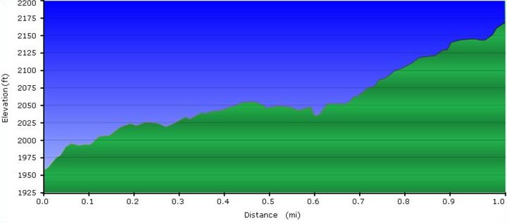
1,025 Ft312.42 Meters <br /> / -804 Ft-245.059 Meters <br />
|
| High Point
|
2,145 Ft715 Yards <br />653.796 Meters <br />
|
| Parking
|
36° 30' 31.76" N, 82° 36' 34.36" W
|
| Trailhead
|
36° 30' 48.91" N, 82° 36' 22.00" W
|
| Nearest Medical
|
Kingsport, TN
|
| Trip Reports
|
Click Here
|
|
|
Loading map... {"type":"ROADMAP","minzoom":false,"maxzoom":false,"types":["ROADMAP","SATELLITE","HYBRID","TERRAIN"],"mappingservice":"googlemaps3","width":"270px","height":"180px","centre":false,"title":"","label":"","icon":"","lines":[],"polygons":[],"circles":[],"rectangles":[],"copycoords":false,"static":false,"visitedicon":"","wmsoverlay":false,"zoom":8,"layers":[],"controls":["zoom"],"zoomstyle":"DEFAULT","typestyle":"DEFAULT","autoinfowindows":false,"resizable":false,"kmlrezoom":false,"poi":true,"cluster":false,"clustergridsize":60,"clustermaxzoom":20,"clusterzoomonclick":true,"clusteraveragecenter":true,"clusterminsize":2,"imageoverlays":[],"kml":[],"gkml":[],"searchmarkers":"","fullscreen":false,"scrollwheelzoom":false,"locations":[{"text":"","title":"","link":"","lat":36.5088209999999975252649164758622646331787109375,"lon":-82.609544999999997116901795379817485809326171875,"icon":""}]} |
|
| Show Large Map
|
|
Trail Overview
Located in Bays Mountain Park. Parallel alternative for Azalea up to the Antennas - or return loop option. Nice hike or ride through forest of maples, tulip poplars, ferns, oaks, and other hardwoods.
How to get there
From the main parking lot, pass through or around the bird and wolf habitats to reach Lake Road. Continue around to marked trailhead.
Route Description
The path runs parallel and across the hollow from Azalea Trail. Continue up to Bays Mountain Road and over to the Antennas for an overlook of downtown Kingsport.
This trail has connections to Azalea, Chinquapin Trail, and Lake Road
Typical Conditions
Hard packed trail along former logging road. The local mountain biking club has rerouted a section of the trail to give a more interesting path through the forest (although some of the former white blazes can still be seen which need to be covered).
Misc. Information
Maps
Loading map...
{"type":"TERRAIN","minzoom":false,"maxzoom":false,"types":["ROADMAP","SATELLITE","HYBRID","TERRAIN"],"mappingservice":"googlemaps3","width":"auto","height":"550px","centre":{"text":"","title":"","link":"","lat":36.518000000000000682121026329696178436279296875,"lon":-82.605999999999994543031789362430572509765625,"icon":""},"title":"","label":"","icon":"","lines":[],"polygons":[],"circles":[],"rectangles":[],"copycoords":false,"static":false,"visitedicon":"","wmsoverlay":false,"zoom":14,"layers":[],"controls":["pan","zoom","type","scale","streetview","rotate"],"zoomstyle":"DEFAULT","typestyle":"DEFAULT","autoinfowindows":false,"resizable":false,"kmlrezoom":false,"poi":true,"cluster":false,"clustergridsize":60,"clustermaxzoom":20,"clusterzoomonclick":true,"clusteraveragecenter":true,"clusterminsize":2,"imageoverlays":[],"kml":[],"gkml":["http://tehcc.org/clubwiki/kml/BMP_Azalea_Trail.kml","http://tehcc.org/clubwiki/kml/BMP_bays_mountain_road.kml","http://tehcc.org/clubwiki/kml/BMP_Big_Oak_Trail.kml"],"searchmarkers":"","fullscreen":false,"scrollwheelzoom":false,"locations":[{"text":"\u003Cb\u003E\u003Cdiv class=\"mw-parser-output\"\u003E\u003Cp\u003EAntennas, elevation 2250'\n\u003C/p\u003E\u003C/div\u003E\u003C/b\u003E\u003Cdiv class=\"mw-parser-output\"\u003E\u003Cp\u003E\u003Ca href=\"/wiki/File:BMP_Antennas.JPG\" class=\"image\"\u003E\u003Cimg alt=\"BMP Antennas.JPG\" src=\"/clubwiki/images/thumb/BMP_Antennas.JPG/150px-BMP_Antennas.JPG\" decoding=\"async\" width=\"150\" height=\"261\" srcset=\"/clubwiki/images/thumb/BMP_Antennas.JPG/225px-BMP_Antennas.JPG 1.5x, /clubwiki/images/BMP_Antennas.JPG 2x\" data-file-width=\"257\" data-file-height=\"448\" /\u003E\u003C/a\u003E\n\u003C/p\u003E\u003C/div\u003E","title":"Antennas, elevation 2250'\n","link":"","lat":36.5272599999999982856024871580302715301513671875,"lon":-82.5861000000000018417267710901796817779541015625,"icon":"/clubwiki/images/MarkerE.png"},{"text":"\u003Cb\u003E\u003Cdiv class=\"mw-parser-output\"\u003E\u003Cp\u003ETrailhead at \u003Ca href=\"/wiki/Lake_Road_(Bays_Mountain_Park)\" title=\"Lake Road (Bays Mountain Park)\"\u003ELake Road\u003C/a\u003E\n\u003C/p\u003E\u003C/div\u003E\u003C/b\u003E\u003Cdiv class=\"mw-parser-output\"\u003E\u003Cp\u003E\u003Ca href=\"/wiki/File:BMP_Lake_Road_sign_at_Big_Oak_Trail.JPG\" class=\"image\"\u003E\u003Cimg alt=\"BMP Lake Road sign at Big Oak Trail.JPG\" src=\"/clubwiki/images/thumb/BMP_Lake_Road_sign_at_Big_Oak_Trail.JPG/50px-BMP_Lake_Road_sign_at_Big_Oak_Trail.JPG\" decoding=\"async\" width=\"50\" height=\"76\" srcset=\"/clubwiki/images/thumb/BMP_Lake_Road_sign_at_Big_Oak_Trail.JPG/75px-BMP_Lake_Road_sign_at_Big_Oak_Trail.JPG 1.5x, /clubwiki/images/thumb/BMP_Lake_Road_sign_at_Big_Oak_Trail.JPG/100px-BMP_Lake_Road_sign_at_Big_Oak_Trail.JPG 2x\" data-file-width=\"296\" data-file-height=\"448\" /\u003E\u003C/a\u003E\n\u003C/p\u003E\u003C/div\u003E","title":"Trailhead at Lake Road\n","link":"","lat":36.51368000000000080262907431460916996002197265625,"lon":-82.606030000000004065441316924989223480224609375,"icon":"/clubwiki/images/MarkerT.png"},{"text":"\u003Cb\u003E\u003Cdiv class=\"mw-parser-output\"\u003E\u003Cp\u003EJunction with \u003Ca href=\"/wiki/Chinquapin_Trail\" title=\"Chinquapin Trail\"\u003EChinquapin Trail\u003C/a\u003E\n\u003C/p\u003E\u003C/div\u003E\u003C/b\u003E\u003Cdiv class=\"mw-parser-output\"\u003E\u003Cp\u003E\u003Ca href=\"/wiki/File:BMP_Big_Oak_-_Chinquapin_Trail_sign.JPG\" class=\"image\"\u003E\u003Cimg alt=\"BMP Big Oak - Chinquapin Trail sign.JPG\" src=\"/clubwiki/images/thumb/BMP_Big_Oak_-_Chinquapin_Trail_sign.JPG/50px-BMP_Big_Oak_-_Chinquapin_Trail_sign.JPG\" decoding=\"async\" width=\"50\" height=\"175\" srcset=\"/clubwiki/images/thumb/BMP_Big_Oak_-_Chinquapin_Trail_sign.JPG/75px-BMP_Big_Oak_-_Chinquapin_Trail_sign.JPG 1.5x, /clubwiki/images/thumb/BMP_Big_Oak_-_Chinquapin_Trail_sign.JPG/100px-BMP_Big_Oak_-_Chinquapin_Trail_sign.JPG 2x\" data-file-width=\"128\" data-file-height=\"448\" /\u003E\u003C/a\u003E\n\u003C/p\u003E\u003C/div\u003E","title":"Junction with Chinquapin Trail\n","link":"","lat":36.51451999999999742385625722818076610565185546875,"lon":-82.606009999999997717168298549950122833251953125,"icon":"/clubwiki/images/MarkerT.png"},{"text":"\u003Cb\u003E\u003Cdiv class=\"mw-parser-output\"\u003E\u003Cp\u003ETrailhead at \u003Ca href=\"/wiki/Azalea\" title=\"Azalea\"\u003EAzalea\u003C/a\u003E\n\u003C/p\u003E\u003C/div\u003E\u003C/b\u003E\u003Cdiv class=\"mw-parser-output\"\u003E\u003Cp\u003E\u003Ca href=\"/wiki/File:BMP_Split_at_Azalea_and_Big_Oak_Trails.JPG\" class=\"image\"\u003E\u003Cimg alt=\"BMP Split at Azalea and Big Oak Trails.JPG\" src=\"/clubwiki/images/thumb/BMP_Split_at_Azalea_and_Big_Oak_Trails.JPG/150px-BMP_Split_at_Azalea_and_Big_Oak_Trails.JPG\" decoding=\"async\" width=\"150\" height=\"113\" srcset=\"/clubwiki/images/thumb/BMP_Split_at_Azalea_and_Big_Oak_Trails.JPG/225px-BMP_Split_at_Azalea_and_Big_Oak_Trails.JPG 1.5x, /clubwiki/images/thumb/BMP_Split_at_Azalea_and_Big_Oak_Trails.JPG/300px-BMP_Split_at_Azalea_and_Big_Oak_Trails.JPG 2x\" data-file-width=\"448\" data-file-height=\"336\" /\u003E\u003C/a\u003E\n\u003C/p\u003E\u003C/div\u003E","title":"Trailhead at Azalea\n","link":"","lat":36.522210000000001173248165287077426910400390625,"lon":-82.5928300000000064073901739902794361114501953125,"icon":"/clubwiki/images/MarkerT.png"}]}
- The following elevation profile proceeds from Lake Road to junction with Azalea Trail.
Photos

