|
|
| Line 1: |
Line 1: |
| <!-- The following few lines create the "Infobox" table template. Please scroll down to edit the main content of the article. --> | | <!-- The following few lines create the "Infobox" table template. Please scroll down to edit the main content of the article. |
| {{Infobox Trail | | -->{{Infobox Trail |
| | Image Name = BMP_Bear_Run_Trail.JPG | | | Image Name = BMP_Bear_Run_Trail.JPG |
| | Trail Number = | | | Trail Number = |
| Line 19: |
Line 19: |
| | Trailhead coords = 36.508720,-82.636631 | | | Trailhead coords = 36.508720,-82.636631 |
| | Medical = Kingsport, TN | | | Medical = Kingsport, TN |
| }} | | }}<!-- |
| <!-- End Infobox template table--> | | |
| <!-- Start of Main Page --> | | End Infobox template table |
| | |
| | -->{{Trail page needs |
| | | Hide needs = |
| | | KML = |
| | | Updated KML = |
| | | Detail route description = |
| | | Photos = Yes |
| | | Winter photos = |
| | | Remove prefix = |
| | | Update infobox = |
| | | Infobox data update = |
| | | Trail pins = |
| | | Other = |
| | | Comment = |
| | | Date reviewed = 10/24/2015 |
| | }}<!-- |
| | |
| | Start of Main Page --> |
| == Trail Overview == | | == Trail Overview == |
| <!-- Enter a overview of the trail. What attracts you to this trail, points of interest, types of flowers, lakes, and peaks that you see along the way. --> | | <!-- Enter a overview of the trail. What attracts you to this trail, points of interest, types of flowers, lakes, and peaks that you see along the way. --> |
| Line 67: |
Line 85: |
| http://tehcc.org/clubwiki/kml/BMP_lake_road.kml, | | http://tehcc.org/clubwiki/kml/BMP_lake_road.kml, |
| http://tehcc.org/clubwiki/kml/BMP_river_mountain_road.kml, | | http://tehcc.org/clubwiki/kml/BMP_river_mountain_road.kml, |
| http://tehcc.org/clubwiki/kml/BMP_Indian_Pipes_Trail.kml, | | http://tehcc.org/clubwiki/kml/BMP_Indian_Pipes_Trail.kml"> |
| http://maps.google.com/maps/ms?msa=0&msid=209607530600230669321.0004a782910eebe8a0387&output=kml">
| |
|
| |
|
| 36.508732,-82.636652~Trailhead at [[Indian Pipes Trail|Indian Pipes Trail]]~A temporary bank sign from a bike rally at intersection~MarkerT.png | | 36.508732,-82.636652~Trailhead at [[Indian Pipes Trail|Indian Pipes Trail]]~A temporary bank sign from a bike rally at intersection~MarkerT.png |
| 36.508531,-82.629947~Trailhead at [[River Mountain Road|River Mountain Road]]~[[Image:BMP BET-RM.JPG|50px]]<br>[[Image:BMP BET-BHR sign.JPG|50px]]~MarkerT.png | | 36.508531,-82.629947~Trailhead at [[River Mountain Road|River Mountain Road]]~[[Image:BMP BET-RM.JPG|100px]] [[Image:BMP BET-BHR sign.JPG|100px]]~MarkerT.png |
| </display_map> | | </display_map> |
|
| |
|
| Line 85: |
Line 102: |
| <!-- Finally add the trail to any Categories it should belong to. --> | | <!-- Finally add the trail to any Categories it should belong to. --> |
| [[Category:Tennessee]] [[Category:Kingsport]] [[Category:Bays Mountain Park]] [[Category:Medium]] [[Category:Hiking]] [[Category:Biking]] [[Category:Dog Friendly]] | | [[Category:Tennessee]] [[Category:Kingsport]] [[Category:Bays Mountain Park]] [[Category:Medium]] [[Category:Hiking]] [[Category:Biking]] [[Category:Dog Friendly]] |
| {{#set:
| |
| |Trail page needs=KML;Detail route description;Photos;Trail pins;Update 1|+sep=;
| |
| }}
| |
|
|
|
|
|
| Trail Name
|
Bear Run Trail
|
| Park
|
Bays Mountain Park
|
| Nearest City
|
Kingsport
|
| State
|
Tennessee
|
| Trail Marking
|
Signs
|
| Trail Use/Features
|
  
|
| Difficulty Rating
|
Medium
|
| Hiking Time
|
30 Min0.5 Hours <br />0.0313 Days <br />
|
Distance:
round-trip/trail only
|
3.84 Mi6.18 km <br /> / 2,308 Ft0.437 Mi <br />0.703 km <br />
|
| Trail Type
|
Segment
|
| Climb/Descent Elevation
|
147 Ft44.806 Meters <br /> / -333 Ft-101.498 Meters <br />
|
| High Point
|
2,317 Ft772.333 Yards <br />706.222 Meters <br />
|
| Parking
|
36° 30' 31.76" N, 82° 36' 34.36" W
|
| Trailhead
|
36° 30' 31.39" N, 82° 38' 11.87" W
|
| Nearest Medical
|
Kingsport, TN
|
| Trip Reports
|
Click Here
|
|
|
Loading map... {"type":"ROADMAP","minzoom":false,"maxzoom":false,"types":["ROADMAP","SATELLITE","HYBRID","TERRAIN"],"mappingservice":"googlemaps3","width":"270px","height":"180px","centre":false,"title":"","label":"","icon":"","lines":[],"polygons":[],"circles":[],"rectangles":[],"copycoords":false,"static":false,"visitedicon":"","wmsoverlay":false,"zoom":8,"layers":[],"controls":["zoom"],"zoomstyle":"DEFAULT","typestyle":"DEFAULT","autoinfowindows":false,"resizable":false,"kmlrezoom":false,"poi":true,"cluster":false,"clustergridsize":60,"clustermaxzoom":20,"clusterzoomonclick":true,"clusteraveragecenter":true,"clusterminsize":2,"imageoverlays":[],"kml":[],"gkml":[],"searchmarkers":"","fullscreen":false,"scrollwheelzoom":false,"locations":[{"text":"","title":"","link":"","lat":36.5088209999999975252649164758622646331787109375,"lon":-82.609544999999997116901795379817485809326171875,"icon":""}]} |
|
| Show Large Map
|
|
Trail Overview
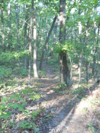
Located in Bays Mountain Park. New mountain biking trail constructed by the local club. Good short alternate ride or hike downhill through hardwood forest.
How to get there
Most folks are going to ride this trail down from Indian Pipes - likely after visiting the fire tower. Others might hike it up as a loop with sections of Indian Pipes, Pretty Ridge, and Back Hollow Road.
Route Description
The path meanders through the forest on a route originally constructed as a hiking trail back in late 1990s. It has connections to Indian Pipes Trail and River Mountain Road.
Unless the section of Indian Pipes Trail has been renamed, this Bear Run Trail is half the distance shown on the Bays Mountain park map. The distance from River Mountain Road over to the upper trailhead is 0.7 miles.
Typical Conditions
Hard packed trail with groove down the middle from the mountain bikes. Some rocks located at key spots.
Misc. Information
Maps
Loading map...
{"type":"TERRAIN","minzoom":false,"maxzoom":false,"types":["ROADMAP","SATELLITE","HYBRID","TERRAIN"],"mappingservice":"googlemaps3","width":"725px","height":"350px","centre":{"text":"","title":"","link":"","lat":36.50999999999999801048033987171947956085205078125,"lon":-82.6350000000000051159076974727213382720947265625,"icon":""},"title":"","label":"","icon":"","lines":[],"polygons":[],"circles":[],"rectangles":[],"copycoords":false,"static":false,"visitedicon":"","wmsoverlay":false,"zoom":15,"layers":[],"controls":["pan","zoom","type","scale","streetview","rotate"],"zoomstyle":"DEFAULT","typestyle":"DEFAULT","autoinfowindows":false,"resizable":false,"kmlrezoom":false,"poi":true,"cluster":false,"clustergridsize":60,"clustermaxzoom":20,"clusterzoomonclick":true,"clusteraveragecenter":true,"clusterminsize":2,"imageoverlays":[],"kml":[],"gkml":["http://tehcc.org/clubwiki/kml/BMP_Bear_Run_Trail.kml","http://tehcc.org/clubwiki/kml/BMP_lake_road.kml","http://tehcc.org/clubwiki/kml/BMP_river_mountain_road.kml","http://tehcc.org/clubwiki/kml/BMP_Indian_Pipes_Trail.kml"],"searchmarkers":"","fullscreen":false,"scrollwheelzoom":false,"locations":[{"text":"\u003Cb\u003E\u003Cdiv class=\"mw-parser-output\"\u003E\u003Cp\u003ETrailhead at \u003Ca href=\"/wiki/Indian_Pipes_Trail\" title=\"Indian Pipes Trail\"\u003EIndian Pipes Trail\u003C/a\u003E\n\u003C/p\u003E\u003C/div\u003E\u003C/b\u003E\u003Cdiv class=\"mw-parser-output\"\u003E\u003Cp\u003EA temporary bank sign from a bike rally at intersection\n\u003C/p\u003E\u003C/div\u003E","title":"Trailhead at Indian Pipes Trail\n","link":"","lat":36.50873200000000196041582967154681682586669921875,"lon":-82.636651999999997997292666696012020111083984375,"icon":"/clubwiki/images/MarkerT.png"},{"text":"\u003Cb\u003E\u003Cdiv class=\"mw-parser-output\"\u003E\u003Cp\u003ETrailhead at \u003Ca href=\"/wiki/River_Mountain_Road\" title=\"River Mountain Road\"\u003ERiver Mountain Road\u003C/a\u003E\n\u003C/p\u003E\u003C/div\u003E\u003C/b\u003E\u003Cdiv class=\"mw-parser-output\"\u003E\u003Cp\u003E\u003Ca href=\"/wiki/File:BMP_BET-RM.JPG\" class=\"image\"\u003E\u003Cimg alt=\"BMP BET-RM.JPG\" src=\"/clubwiki/images/thumb/BMP_BET-RM.JPG/100px-BMP_BET-RM.JPG\" decoding=\"async\" width=\"100\" height=\"71\" srcset=\"/clubwiki/images/thumb/BMP_BET-RM.JPG/150px-BMP_BET-RM.JPG 1.5x, /clubwiki/images/thumb/BMP_BET-RM.JPG/200px-BMP_BET-RM.JPG 2x\" data-file-width=\"448\" data-file-height=\"317\" /\u003E\u003C/a\u003E \u003Ca href=\"/wiki/File:BMP_BET-BHR_sign.JPG\" class=\"image\"\u003E\u003Cimg alt=\"BMP BET-BHR sign.JPG\" src=\"/clubwiki/images/thumb/BMP_BET-BHR_sign.JPG/100px-BMP_BET-BHR_sign.JPG\" decoding=\"async\" width=\"100\" height=\"69\" srcset=\"/clubwiki/images/thumb/BMP_BET-BHR_sign.JPG/150px-BMP_BET-BHR_sign.JPG 1.5x, /clubwiki/images/thumb/BMP_BET-BHR_sign.JPG/200px-BMP_BET-BHR_sign.JPG 2x\" data-file-width=\"448\" data-file-height=\"307\" /\u003E\u003C/a\u003E\n\u003C/p\u003E\u003C/div\u003E","title":"Trailhead at River Mountain Road\n","link":"","lat":36.50853099999999784586179885081946849822998046875,"lon":-82.6299470000000013669705367647111415863037109375,"icon":"/clubwiki/images/MarkerT.png"}]}
Photos
