Bays Ridge Road
| |||||||||||||||||||||||||||||||||||||
Trail Overview
Located in Bays Mountain Park. Park road along the SW edge of the park. High views across the valley and to Appalachian Mountains.
How to get there
From the main parking lot, cross the dam and take the left onto Lake Road for a few stop and then left again on Bays Ridge Road. Follows the ridgeline until Bays Ridge Trail splits off, and then it heads down to Ledbetter Gap.
Route Description
Short 0.3 mile, but very steep connecting road. There is a split in the middle which rejoins.
| Miles | Jones Road | Miles |
|---|---|---|
| 0.0 | Trailhead at Front Hollow Road by the "Big Oak". No trail sign, but steepest path up from here. | 0.3 |
| 0.3 | Trailhead at Bays Ridge Road | 0.0 |
Typical Conditions
Severely washed out road on steep slopes, and natural gravel on top. Water will be flowing down thru the rut.
Misc. Information
Not shown on the park map, but Jones Road may continue down Bays Ridge to Reservoir Road.
Maps
<googlemap version="0.9" lat="36.49210" lon="-82.63372" type="terrain" zoom="15" width="735" scale="yes" icons="http://tehcc.org/clubwiki/kml/marker{label}.png"> http://tehcc.org/clubwiki/kml/BMP_Jones_Road.kml http://tehcc.org/clubwiki/kml/BMP_Front_Hollow_Road.kml http://tehcc.org/clubwiki/kml/BMP_Bays_Ridge_Road.kml
(G) 36.49603,-82.63158
Junction with Front Hollow Road by "Big Oak"
 (G) 36.49210,-82.63372
Junction with Bays Ridge Road
</googlemap>
(G) 36.49210,-82.63372
Junction with Bays Ridge Road
</googlemap>
- The following elevation profile travels from Front Hollow Road up to Bays Ridge Road.
File:BMP Jones Road profile.JPG
Photos
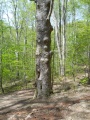
Big Oak at bottom of Jones Road