|
|
| Line 1: |
Line 1: |
| <!-- The following few lines create the "Infobox" table template. Please scroll down to edit the main content of the article. --> | | <!-- The following few lines create the "Infobox" table template. Please scroll down to edit the main content of the article. --> |
| {{Infobox Trail | | {{Infobox Trail |
| | Image Name = BMP Bays Ridge Road overlook.JPG
| | | Image Name = BMP Bays Ridge Road overlook.JPG |
| | City = Kingsport
| | | Park = Bays Mountain Park |
| | State = Tennessee
| | | City = Kingsport |
| | Marking = Junction Signs
| | | State = Tennessee |
| | Trail Use = {{Hike}} {{Biking}} {{Dogs}}
| | | Marking = Junction Signs |
| | Difficulty Rating = Medium
| | | Trail Use = {{Hike}} {{Biking}} {{Dogs}} |
| | Hike Time = 0.75
| | | Difficulty Rating = Medium |
| | Distance = 1.4
| | | Hike Time = 45 Min |
| | Elevation Gain = 450
| | | Distance = 1.4 Mi |
| | High Point = 2246
| | | Elevation Gain = 571 Ft |
| | Latitude = 36.49487
| | | Elevation Loss = -394 Ft |
| | Longitude = -82.60517
| | | High Point = 2,327 Ft |
| | Medical = Kingsport, TN
| | | Latitude = 36.49487 |
| | | Longitude = -82.60517 |
| | | Medical = Kingsport, TN |
| }} | | }} |
| <!-- End Infobox template table--> | | <!-- End Infobox template table--> |
| Line 76: |
Line 78: |
| <!-- You can place pictures, PDF's, links, or even create a Google map with your waypoints and place it here. --> | | <!-- You can place pictures, PDF's, links, or even create a Google map with your waypoints and place it here. --> |
| On the following contour map, the dark brick red path is Bays Ridge Road. Orange is Lake Road. Red is Pine Trail. Purple is Orchid Trail. Yellow is Front Hollow Road. | | On the following contour map, the dark brick red path is Bays Ridge Road. Orange is Lake Road. Red is Pine Trail. Purple is Orchid Trail. Yellow is Front Hollow Road. |
| <googlemap version="0.9" lat="36.5030" lon="-82.6232" type="terrain" zoom="15" width="700" scale="yes" icons="http://tehcc.org/clubwiki/kml/marker{label}.png"> | | <display_map center="36.5030,-82.6232" type="terrain" zoom="15" width="auto" height="550" gkml="http://tehcc.org/clubwiki/kml/BMP_Front_Hollow_Road.kml, |
| http://tehcc.org/clubwiki/kml/BMP_Front_Hollow_Road.kml | | http://tehcc.org/clubwiki/kml/BMP_Bays_Ridge_Road.kml, |
| http://tehcc.org/clubwiki/kml/BMP_Bays_Ridge_Road.kml | | http://tehcc.org/clubwiki/kml/BMP_lake_road.kml, |
| http://tehcc.org/clubwiki/kml/BMP_lake_road.kml | | http://tehcc.org/clubwiki/kml/BMP_Orchid_Trail.kml, |
| http://tehcc.org/clubwiki/kml/BMP_Orchid_Trail.kml | | http://tehcc.org/clubwiki/kml/BMP_Pine_Trail.kml, |
| http://tehcc.org/clubwiki/kml/BMP_Pine_Trail.kml | | http://tehcc.org/clubwiki/kml/BMP_Bays_Ridge_Trail.kml"> |
| http://tehcc.org/clubwiki/kml/BMP_Bays_Ridge_Trail.kml | |
|
| |
|
| (G) 36.507613,-82.612658
| | 36.507613,-82.612658~Road starts at [[BMP Lake Road|Lake Road]] by reservoir dam~[[Image:BMP_LakeRd-BaysRidgeRd sign.JPG|50px]]~MarkerG.png |
| Road starts at [[BMP Lake Road|Lake Road]] by reservoir dam | | 36.50631,-82.61311~Junction with [[BMP Pine Trail|Pine Trail]]~ ~MarkerG.png |
| [[Image:BMP_LakeRd-BaysRidgeRd sign.JPG|50px]] | | 36.50049,-82.61786~Junction with [[BMP Orchid Trail|Orchid Trail]]~[[Image:BMP Orchid Trail sign2.JPG|50px]]~MarkerG.png |
| (G) 36.50631,-82.61311
| | 36.497900,-82.627713~Road starts at Ledbetter Gap~[[Image:BMP_Ledbetter_Gap_sign.JPG|150px]]<br>Crossroads with [[BMP Lake Road|Lake Road]] and [[BMP Front Hollow Road|Front Hollow Road]]~MarkerG.png |
| Junction with [[BMP Pine Trail|Pine Trail]] | | </display_map> |
| (G) 36.50049,-82.61786
| |
| Junction with [[BMP Orchid Trail|Orchid Trail]] | |
| [[Image:BMP Orchid Trail sign2.JPG|50px]] | |
| (G) 36.497900,-82.627713
| |
| Road starts at Ledbetter Gap | |
| [[Image:BMP_Ledbetter_Gap_sign.JPG|150px]] | |
| Crossroads with [[BMP Lake Road|Lake Road]] | |
| and [[BMP Front Hollow Road|Front Hollow Road]] | |
| </googlemap> | |
|
| |
|
|
| |
|
|
|
|
|
|
| Trail Name
|
Bays Ridge Road
|
| Park
|
Bays Mountain Park
|
| Nearest City
|
Kingsport
|
| State
|
Tennessee
|
| Trail Marking
|
Junction Signs
|
| Trail Use/Features
|
  
|
| Difficulty Rating
|
Medium
|
| Hiking Time
|
45 Min0.75 Hours <br />0.0469 Days <br />
|
| Distance, round-trip
|
1.4 Mi2.253 km <br />
|
| Climb/Descent Elevation
|
571 Ft174.041 Meters <br /> / -394 Ft-120.091 Meters <br />
|
| High Point
|
2,327 Ft775.667 Yards <br />709.27 Meters <br />
|
| Nearest Medical
|
Kingsport, TN
|
| Trip Reports
|
Click Here
|
|
|
Loading map... {"type":"ROADMAP","minzoom":false,"maxzoom":false,"types":["ROADMAP","SATELLITE","HYBRID","TERRAIN"],"mappingservice":"googlemaps3","width":"270px","height":"180px","centre":false,"title":"","label":"","icon":"","lines":[],"polygons":[],"circles":[],"rectangles":[],"copycoords":false,"static":false,"visitedicon":"","wmsoverlay":false,"zoom":8,"layers":[],"controls":["zoom"],"zoomstyle":"DEFAULT","typestyle":"DEFAULT","autoinfowindows":false,"resizable":false,"kmlrezoom":false,"poi":true,"cluster":false,"clustergridsize":60,"clustermaxzoom":20,"clusterzoomonclick":true,"clusteraveragecenter":true,"clusterminsize":2,"imageoverlays":[],"kml":[],"gkml":[],"searchmarkers":"","fullscreen":false,"scrollwheelzoom":false,"locations":[{"text":"","title":"","link":"","lat":36.49486999999999881083567743189632892608642578125,"lon":-82.6051700000000010959411156363785266876220703125,"icon":""}]} |
|
| Show Large Map
|
|
Trail Overview
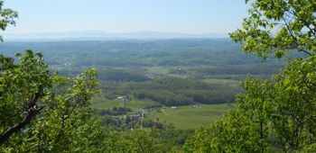
Located in Bays Mountain Park. Park road along the SW edge of the park. High views across the valley and to Appalachian Mountains.
How to get there
From the main parking lot, cross the dam and take the left onto Lake Road for a few stop and then left again on Bays Ridge Road. Follows the ridgeline until Bays Ridge Trail splits off, and then it heads down to Ledbetter Gap.
Route Description
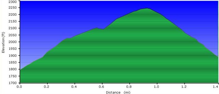
1.4 mile from Lake Road by dam to up, down, and rejoining Lake Road at Ledbetter Gap.
| Miles
|
Bays Ridge Road
|
Miles
|
Elevation (ft)
|
| 0.0
|
Trailhead at Lake Road near reservoir dam
|
1.4
|
1835
|
| 0.1
|
Junction with Pine Trail which heads downhill to the north
|
1.3
|
|
| 0.6
|
Junction with Orchid Trail which heads downhill to the north
|
0.8
|
2156
|
| 0.9
|
Junction with Bays Ridge Trail continues to SW along ridge line while Bays Ridge Road heads downhill
|
0.5
|
2285
|
| 1.6
|
Ledbetter Gap - Junction also with Lake Road and Front Hollow Road
|
0.0
|
1920
|
Typical Conditions
Mostly a gravel road, but severely washed out on steep slopes (needs water bars installed to get the runoff away from the road bed).
The road can be ridden by mountain bike along the ridge crest. The section down to Ledbetter Gap will require some dismounting and walking around the worst ruts.
Misc. Information
During the section closest to the dam, the road passes between two parallel ridges of sandstone.
Maps
On the following contour map, the dark brick red path is Bays Ridge Road. Orange is Lake Road. Red is Pine Trail. Purple is Orchid Trail. Yellow is Front Hollow Road.
Loading map...
{"type":"TERRAIN","minzoom":false,"maxzoom":false,"types":["ROADMAP","SATELLITE","HYBRID","TERRAIN"],"mappingservice":"googlemaps3","width":"auto","height":"550px","centre":{"text":"","title":"","link":"","lat":36.5030000000000001136868377216160297393798828125,"lon":-82.623199999999997089616954326629638671875,"icon":""},"title":"","label":"","icon":"","lines":[],"polygons":[],"circles":[],"rectangles":[],"copycoords":false,"static":false,"visitedicon":"","wmsoverlay":false,"zoom":15,"layers":[],"controls":["pan","zoom","type","scale","streetview","rotate"],"zoomstyle":"DEFAULT","typestyle":"DEFAULT","autoinfowindows":false,"resizable":false,"kmlrezoom":false,"poi":true,"cluster":false,"clustergridsize":60,"clustermaxzoom":20,"clusterzoomonclick":true,"clusteraveragecenter":true,"clusterminsize":2,"imageoverlays":[],"kml":[],"gkml":["http://tehcc.org/clubwiki/kml/BMP_Front_Hollow_Road.kml","http://tehcc.org/clubwiki/kml/BMP_Bays_Ridge_Road.kml","http://tehcc.org/clubwiki/kml/BMP_lake_road.kml","http://tehcc.org/clubwiki/kml/BMP_Orchid_Trail.kml","http://tehcc.org/clubwiki/kml/BMP_Pine_Trail.kml","http://tehcc.org/clubwiki/kml/BMP_Bays_Ridge_Trail.kml"],"searchmarkers":"","fullscreen":false,"scrollwheelzoom":false,"locations":[{"text":"\u003Cb\u003E\u003Cdiv class=\"mw-parser-output\"\u003E\u003Cp\u003ERoad starts at \u003Ca href=\"/wiki/BMP_Lake_Road\" class=\"mw-redirect\" title=\"BMP Lake Road\"\u003ELake Road\u003C/a\u003E by reservoir dam\n\u003C/p\u003E\u003C/div\u003E\u003C/b\u003E\u003Cdiv class=\"mw-parser-output\"\u003E\u003Cp\u003E\u003Ca href=\"/wiki/File:BMP_LakeRd-BaysRidgeRd_sign.JPG\" class=\"image\"\u003E\u003Cimg alt=\"BMP LakeRd-BaysRidgeRd sign.JPG\" src=\"/clubwiki/images/thumb/BMP_LakeRd-BaysRidgeRd_sign.JPG/50px-BMP_LakeRd-BaysRidgeRd_sign.JPG\" decoding=\"async\" width=\"50\" height=\"179\" srcset=\"/clubwiki/images/thumb/BMP_LakeRd-BaysRidgeRd_sign.JPG/75px-BMP_LakeRd-BaysRidgeRd_sign.JPG 1.5x, /clubwiki/images/thumb/BMP_LakeRd-BaysRidgeRd_sign.JPG/100px-BMP_LakeRd-BaysRidgeRd_sign.JPG 2x\" data-file-width=\"125\" data-file-height=\"448\" /\u003E\u003C/a\u003E\n\u003C/p\u003E\u003C/div\u003E","title":"Road starts at Lake Road by reservoir dam\n","link":"","lat":36.50761299999999920373738859780132770538330078125,"lon":-82.6126579999999961501089273951947689056396484375,"icon":"/clubwiki/images/MarkerG.png"},{"text":"\u003Cdiv class=\"mw-parser-output\"\u003E\u003Cp\u003EJunction with \u003Ca href=\"/wiki/BMP_Pine_Trail\" class=\"mw-redirect\" title=\"BMP Pine Trail\"\u003EPine Trail\u003C/a\u003E\n\u003C/p\u003E\u003C/div\u003E","title":"Junction with Pine Trail\n","link":"","lat":36.5063099999999991496224538423120975494384765625,"lon":-82.613110000000006039044819772243499755859375,"icon":"/clubwiki/images/MarkerG.png"},{"text":"\u003Cb\u003E\u003Cdiv class=\"mw-parser-output\"\u003E\u003Cp\u003EJunction with \u003Ca href=\"/wiki/BMP_Orchid_Trail\" class=\"mw-redirect\" title=\"BMP Orchid Trail\"\u003EOrchid Trail\u003C/a\u003E\n\u003C/p\u003E\u003C/div\u003E\u003C/b\u003E\u003Cdiv class=\"mw-parser-output\"\u003E\u003Cp\u003E\u003Ca href=\"/wiki/File:BMP_Orchid_Trail_sign2.JPG\" class=\"image\"\u003E\u003Cimg alt=\"BMP Orchid Trail sign2.JPG\" src=\"/clubwiki/images/thumb/BMP_Orchid_Trail_sign2.JPG/50px-BMP_Orchid_Trail_sign2.JPG\" decoding=\"async\" width=\"50\" height=\"109\" srcset=\"/clubwiki/images/thumb/BMP_Orchid_Trail_sign2.JPG/75px-BMP_Orchid_Trail_sign2.JPG 1.5x, /clubwiki/images/thumb/BMP_Orchid_Trail_sign2.JPG/100px-BMP_Orchid_Trail_sign2.JPG 2x\" data-file-width=\"206\" data-file-height=\"448\" /\u003E\u003C/a\u003E\n\u003C/p\u003E\u003C/div\u003E","title":"Junction with Orchid Trail\n","link":"","lat":36.5004899999999992132870829664170742034912109375,"lon":-82.6178599999999931924321572296321392059326171875,"icon":"/clubwiki/images/MarkerG.png"},{"text":"\u003Cb\u003E\u003Cdiv class=\"mw-parser-output\"\u003E\u003Cp\u003ERoad starts at Ledbetter Gap\n\u003C/p\u003E\u003C/div\u003E\u003C/b\u003E\u003Cdiv class=\"mw-parser-output\"\u003E\u003Cp\u003E\u003Ca href=\"/wiki/File:BMP_Ledbetter_Gap_sign.JPG\" class=\"image\"\u003E\u003Cimg alt=\"BMP Ledbetter Gap sign.JPG\" src=\"/clubwiki/images/thumb/BMP_Ledbetter_Gap_sign.JPG/150px-BMP_Ledbetter_Gap_sign.JPG\" decoding=\"async\" width=\"150\" height=\"148\" srcset=\"/clubwiki/images/thumb/BMP_Ledbetter_Gap_sign.JPG/225px-BMP_Ledbetter_Gap_sign.JPG 1.5x, /clubwiki/images/thumb/BMP_Ledbetter_Gap_sign.JPG/300px-BMP_Ledbetter_Gap_sign.JPG 2x\" data-file-width=\"340\" data-file-height=\"336\" /\u003E\u003C/a\u003E\u003Cbr /\u003ECrossroads with \u003Ca href=\"/wiki/BMP_Lake_Road\" class=\"mw-redirect\" title=\"BMP Lake Road\"\u003ELake Road\u003C/a\u003E and \u003Ca href=\"/wiki/BMP_Front_Hollow_Road\" class=\"mw-redirect\" title=\"BMP Front Hollow Road\"\u003EFront Hollow Road\u003C/a\u003E\n\u003C/p\u003E\u003C/div\u003E","title":"Road starts at Ledbetter Gap\n","link":"","lat":36.4979000000000013415046851150691509246826171875,"lon":-82.627712999999999965439201332628726959228515625,"icon":"/clubwiki/images/MarkerG.png"}]}
- The following elevation profile travels from near reservior dam up and down to Ledbetter Gap.
Photos

