|
|
| Line 2: |
Line 2: |
| {{Infobox Trail | | {{Infobox Trail |
| | Image Name = BMP Bays Mountain Road gate.JPG | | | Image Name = BMP Bays Mountain Road gate.JPG |
| | | Trail Number = |
| | Park = Bays Mountain Park | | | Park = Bays Mountain Park |
| | City = Kingsport | | | City = Kingsport |
| | State = Tennessee | | | State = Tennessee |
| | Marking = Junction Signs | | | Marking = Signs |
| | Trail Use = {{Hike}} {{Biking}} {{Dogs}} | | | Trail Use = {{Hike}} {{Biking}} {{Dogs}} |
| | Difficulty Rating = Moderate | | | Difficulty Rating = Medium |
| | Hike Time = 2 Hours | | | Hike Time = 2 Hours |
| | Distance = 2.1 Miles | | | Round Trip Distance = 4.2 Mi |
| | Elevation Gain = 393 Ft | | | Trail Distance = 2.1 Mi |
| | High Point = 2237 Ft | | | Trail Type = In-and-Out |
| | Latitude = 36.508537 | | | Elevation Gain = 775 Ft |
| | Longitude = -82.611171 | | | Elevation Loss = -350 Ft |
| | | High Point = 2,312 Ft |
| | | Parking coords = 36.508821,-82.609545 |
| | | Trailhead coords = 36.508537,-82.611171 |
| | Medical = Kingsport, TN | | | Medical = Kingsport, TN |
| }} | | }} |
| <!-- End Infobox template table--> | | <!-- End Infobox template table--> |
|
| |
| <!-- Start of Main Page --> | | <!-- Start of Main Page --> |
|
| |
| == Trail Overview == | | == Trail Overview == |
| <!-- Enter a overview of the trail. What attracts you to this trail, points of interest, types of flowers, lakes, and peaks that you see along the way. --> | | <!-- Enter a overview of the trail. What attracts you to this trail, points of interest, types of flowers, lakes, and peaks that you see along the way. --> |
| Line 30: |
Line 32: |
| == Route Description== | | == Route Description== |
| <!-- Detailed description of the route. Is there any side trails that are worth traveling? --> | | <!-- Detailed description of the route. Is there any side trails that are worth traveling? --> |
| The path starts off fairly steep but levels off once on the ridge. This trail meets up with [[BMP River Mountain Road|River Mountain Road]] and [[BMP Azalea Trail|Azalea Trail]] for possible loops hikes | | The path starts off fairly steep but levels off once on the ridge. |
|
| |
|
| | This trail has connections to [[Trail connects to::Lake Road (Bays Mountain Park)]], [[Trail connects to::River Mountain Road]], and [[Trail connects to::Azalea]] |
|
| |
|
| {| class="wikitable" border="1" | | {| class="wikitable" border="1" |
| Line 63: |
Line 66: |
| <!-- Typical conditions throughout the year of what to expect on the trail. Rocky, muddy, sandy, flowers, lots of downed trees? --> | | <!-- Typical conditions throughout the year of what to expect on the trail. Rocky, muddy, sandy, flowers, lots of downed trees? --> |
| The trail is fairly wide to allow service trucks and can be rutted and with puddles in wetter months. | | The trail is fairly wide to allow service trucks and can be rutted and with puddles in wetter months. |
|
| |
| == Fees, Permits, etc. ==
| |
| <!-- Please list any Fees, Permits, Regulations, etc. that may be required on this trail.-->
| |
| See the [[Bays Mountain Park]] page for details
| |
|
| |
| == After the Hike ==
| |
| <!-- Other things to check out while you're in the area. Restaurants, attractions, monuments, etc... -->
| |
| Visit the other trails, animal exhibits, and Nature Center
| |
|
| |
|
| == Misc. Information == | | == Misc. Information == |
| Line 81: |
Line 76: |
| 36.50843,-82.60449~Lookout tower, elevation 2172'~[[Image:BMP_Cliffside_Trail_lookout.JPG|150px]]~MarkerE.png | | 36.50843,-82.60449~Lookout tower, elevation 2172'~[[Image:BMP_Cliffside_Trail_lookout.JPG|150px]]~MarkerE.png |
| 36.52300,-82.59001~Overlook platform~ ~MarkerE.png | | 36.52300,-82.59001~Overlook platform~ ~MarkerE.png |
| 36.52616,-82.58778,Intersection~[[BMP Azalea Trail]]~MarkerG.png | | 36.52616,-82.58778,Intersection~[[Azalea]]~MarkerG.png |
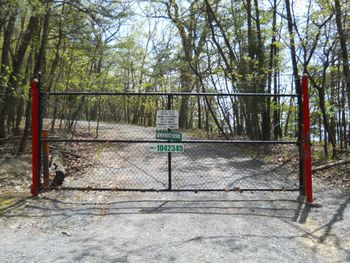
| 36.50706,-82.60979~Locked gate on Bays Mountain Road~[[Image:BMP Bays Mountain Road gate.JPG|150px]]~MarkerG.png | | 36.50706,-82.60979~Locked gate on Bays Mountain Road~[[Image:BMP Bays Mountain Road gate.JPG|150px]]~MarkerG.png |
| 36.52726, -82.5861~Antennas, elevation 2250'~[[Image:BMP Antennas2.JPG|100px]]~MarkerE.png | | 36.52726, -82.5861~Antennas, elevation 2250'~[[Image:BMP Antennas2.JPG|100px]]~MarkerE.png |
| Line 97: |
Line 92: |
| <!-- Finally add the trail to any Categories it should belong to. --> | | <!-- Finally add the trail to any Categories it should belong to. --> |
| [[Category:Tennessee]] [[Category:Kingsport]] [[Category:Bays Mountain Park]] [[Category:Medium]] [[Category:Hiking]] [[Category:Biking]] [[Category:Dog Friendly]] | | [[Category:Tennessee]] [[Category:Kingsport]] [[Category:Bays Mountain Park]] [[Category:Medium]] [[Category:Hiking]] [[Category:Biking]] [[Category:Dog Friendly]] |
| | {{#set: |
| | |Trail page needs=Detail route description;Update 1|+sep=; |
| | }} |
|
|
|
|
|
| Trail Name
|
Bays Mountain Road
|
| Park
|
Bays Mountain Park
|
| Nearest City
|
Kingsport
|
| State
|
Tennessee
|
| Trail Marking
|
Signs
|
| Trail Use/Features
|
  
|
| Difficulty Rating
|
Medium
|
| Hiking Time
|
2 Hours0.125 Days <br />120 Min <br />
|
Distance:
round-trip/trail only
|
4.2 Mi6.759 km <br /> / 2.1 Mi3.38 km <br />
|
| Trail Type
|
In-and-Out
|
| Climb/Descent Elevation
|
775 Ft236.22 Meters <br /> / -350 Ft-106.68 Meters <br />
|
| High Point
|
2,312 Ft770.667 Yards <br />704.698 Meters <br />
|
| Parking
|
36° 30' 31.76" N, 82° 36' 34.36" W
|
| Trailhead
|
36° 30' 30.73" N, 82° 36' 40.22" W
|
| Nearest Medical
|
Kingsport, TN
|
| Trip Reports
|
Click Here
|
|
|
Loading map... {"type":"ROADMAP","minzoom":false,"maxzoom":false,"types":["ROADMAP","SATELLITE","HYBRID","TERRAIN"],"mappingservice":"googlemaps3","width":"270px","height":"180px","centre":false,"title":"","label":"","icon":"","lines":[],"polygons":[],"circles":[],"rectangles":[],"copycoords":false,"static":false,"visitedicon":"","wmsoverlay":false,"zoom":8,"layers":[],"controls":["zoom"],"zoomstyle":"DEFAULT","typestyle":"DEFAULT","autoinfowindows":false,"resizable":false,"kmlrezoom":false,"poi":true,"cluster":false,"clustergridsize":60,"clustermaxzoom":20,"clusterzoomonclick":true,"clusteraveragecenter":true,"clusterminsize":2,"imageoverlays":[],"kml":[],"gkml":[],"searchmarkers":"","fullscreen":false,"scrollwheelzoom":false,"locations":[{"text":"","title":"","link":"","lat":36.5088209999999975252649164758622646331787109375,"lon":-82.609544999999997116901795379817485809326171875,"icon":""}]} |
|
| Show Large Map
|
|
Trail Overview
Located in Bays Mountain Park. This is an vehicle restricted antenna service access road that sees very little traffic. It offers both a lookout tower and overlook area looking southward into Kingsport and the surrounding area. It's wide trail can make it a comfortable social hike for larger groups. This trail also allows bikes once inspected and stickered by park staff.
How to get there
From the main parking lot, go towards the telescope observatory and walk up the road towards the access gate. Follow the trail on the right that will eventually merge with the road on the ridge.
Route Description
The path starts off fairly steep but levels off once on the ridge.
This trail has connections to Lake Road (Bays Mountain Park), River Mountain Road, and Azalea
| Miles
|
Bays Mountain Road
|
Miles
|
| 0.0
|
Lake Road Gate
|
2.1
|
| 0.4
|
Observation Tower/Cliffside Trail junction
|
1.7
|
| 1.7
|
Overlook
|
0.4
|
| 2.0
|
Azalea Trail junction
|
0.1
|
| 2.1
|
antenna point/River Mountain Road junction
|
0.0
|
Typical Conditions
The trail is fairly wide to allow service trucks and can be rutted and with puddles in wetter months.
Misc. Information
Maps
Loading map...
{"type":"TERRAIN","minzoom":false,"maxzoom":false,"types":["ROADMAP","SATELLITE","HYBRID","TERRAIN"],"mappingservice":"googlemaps3","width":"auto","height":"450px","centre":{"text":"","title":"","link":"","lat":36.518000000000000682121026329696178436279296875,"lon":-82.597532000000001062289811670780181884765625,"icon":""},"title":"","label":"","icon":"","lines":[],"polygons":[],"circles":[],"rectangles":[],"copycoords":false,"static":false,"visitedicon":"","wmsoverlay":false,"zoom":14,"layers":[],"controls":["pan","zoom","type","scale","streetview","rotate"],"zoomstyle":"DEFAULT","typestyle":"DEFAULT","autoinfowindows":false,"resizable":false,"kmlrezoom":false,"poi":true,"cluster":false,"clustergridsize":60,"clustermaxzoom":20,"clusterzoomonclick":true,"clusteraveragecenter":true,"clusterminsize":2,"imageoverlays":[],"kml":[],"gkml":["http://tehcc.org/clubwiki/kml/BMP_bays_mountain_road.kml"],"searchmarkers":"","fullscreen":false,"scrollwheelzoom":false,"locations":[{"text":"\u003Cb\u003E\u003Cdiv class=\"mw-parser-output\"\u003E\u003Cp\u003ELookout tower, elevation 2172'\n\u003C/p\u003E\u003C/div\u003E\u003C/b\u003E\u003Cdiv class=\"mw-parser-output\"\u003E\u003Cp\u003E\u003Ca href=\"/wiki/File:BMP_Cliffside_Trail_lookout.JPG\" class=\"image\"\u003E\u003Cimg alt=\"BMP Cliffside Trail lookout.JPG\" src=\"/clubwiki/images/thumb/BMP_Cliffside_Trail_lookout.JPG/150px-BMP_Cliffside_Trail_lookout.JPG\" decoding=\"async\" width=\"150\" height=\"200\" srcset=\"/clubwiki/images/thumb/BMP_Cliffside_Trail_lookout.JPG/225px-BMP_Cliffside_Trail_lookout.JPG 1.5x, /clubwiki/images/thumb/BMP_Cliffside_Trail_lookout.JPG/300px-BMP_Cliffside_Trail_lookout.JPG 2x\" data-file-width=\"768\" data-file-height=\"1024\" /\u003E\u003C/a\u003E\n\u003C/p\u003E\u003C/div\u003E","title":"Lookout tower, elevation 2172'\n","link":"","lat":36.50842999999999705096342950128018856048583984375,"lon":-82.60448999999999841747921891510486602783203125,"icon":"/clubwiki/images/MarkerE.png"},{"text":"\u003Cdiv class=\"mw-parser-output\"\u003E\u003Cp\u003EOverlook platform\n\u003C/p\u003E\u003C/div\u003E","title":"Overlook platform\n","link":"","lat":36.52300000000000324007487506605684757232666015625,"lon":-82.5900100000000065847416408360004425048828125,"icon":"/clubwiki/images/MarkerE.png"},{"text":"\u003Cb\u003E\u003Cdiv class=\"mw-parser-output\"\u003E\u003Cp\u003ELocked gate on Bays Mountain Road\n\u003C/p\u003E\u003C/div\u003E\u003C/b\u003E\u003Cdiv class=\"mw-parser-output\"\u003E\u003Cp\u003E\u003Ca href=\"/wiki/File:BMP_Bays_Mountain_Road_gate.JPG\" class=\"image\"\u003E\u003Cimg alt=\"BMP Bays Mountain Road gate.JPG\" src=\"/clubwiki/images/thumb/BMP_Bays_Mountain_Road_gate.JPG/150px-BMP_Bays_Mountain_Road_gate.JPG\" decoding=\"async\" width=\"150\" height=\"113\" srcset=\"/clubwiki/images/thumb/BMP_Bays_Mountain_Road_gate.JPG/225px-BMP_Bays_Mountain_Road_gate.JPG 1.5x, /clubwiki/images/thumb/BMP_Bays_Mountain_Road_gate.JPG/300px-BMP_Bays_Mountain_Road_gate.JPG 2x\" data-file-width=\"1024\" data-file-height=\"768\" /\u003E\u003C/a\u003E\n\u003C/p\u003E\u003C/div\u003E","title":"Locked gate on Bays Mountain Road\n","link":"","lat":36.50706000000000273075784207321703433990478515625,"lon":-82.609790000000003828972694464027881622314453125,"icon":"/clubwiki/images/MarkerG.png"},{"text":"\u003Cb\u003E\u003Cdiv class=\"mw-parser-output\"\u003E\u003Cp\u003EAntennas, elevation 2250'\n\u003C/p\u003E\u003C/div\u003E\u003C/b\u003E\u003Cdiv class=\"mw-parser-output\"\u003E\u003Cp\u003E\u003Ca href=\"/wiki/File:BMP_Antennas2.JPG\" class=\"image\"\u003E\u003Cimg alt=\"BMP Antennas2.JPG\" src=\"/clubwiki/images/thumb/BMP_Antennas2.JPG/100px-BMP_Antennas2.JPG\" decoding=\"async\" width=\"100\" height=\"320\" srcset=\"/clubwiki/images/BMP_Antennas2.JPG 1.5x\" data-file-width=\"140\" data-file-height=\"448\" /\u003E\u003C/a\u003E\n\u003C/p\u003E\u003C/div\u003E","title":"Antennas, elevation 2250'\n","link":"","lat":36.5272599999999982856024871580302715301513671875,"lon":-82.5861000000000018417267710901796817779541015625,"icon":"/clubwiki/images/MarkerE.png"}]}
Photos
