Most will start at Feagins Gap, thus approach from Lake Road.
Mostly straight shot down hollow. No blazes.
Mountain biking is only to the primitive campsite, then hiking only.
Former gravel road to primitive campsite. Then a dirt road to far west end. While there is a line on the map, that does not mean there is a trail on the ground. Past split to Pretty Ridge Trail has been abandoned by the park, thus no maintenance being done.
Loading map...
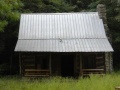
{"type":"TERRAIN","minzoom":false,"maxzoom":false,"types":["ROADMAP","SATELLITE","HYBRID","TERRAIN"],"mappingservice":"googlemaps3","width":"auto","height":"550px","centre":{"text":"","title":"","link":"","lat":36.4969999999999998863131622783839702606201171875,"lon":-82.6400000000000005684341886080801486968994140625,"icon":""},"title":"","label":"","icon":"","lines":[],"polygons":[],"circles":[],"rectangles":[],"copycoords":false,"static":false,"visitedicon":"","wmsoverlay":false,"zoom":14,"layers":[],"controls":["pan","zoom","type","scale","streetview","rotate"],"zoomstyle":"DEFAULT","typestyle":"DEFAULT","autoinfowindows":false,"resizable":false,"kmlrezoom":false,"poi":true,"cluster":false,"clustergridsize":60,"clustermaxzoom":20,"clusterzoomonclick":true,"clusteraveragecenter":true,"clusterminsize":2,"imageoverlays":[],"kml":[],"gkml":["http://tehcc.org/clubwiki/kml/BMP_Back_Hollow_Road.kml","http://tehcc.org/clubwiki/kml/BMP_lake_road.kml","http://tehcc.org/clubwiki/kml/BMP_river_mountain_road.kml","http://tehcc.org/clubwiki/kml/BMP_Pretty_Ridge_Trail.kml"],"searchmarkers":"","fullscreen":false,"scrollwheelzoom":false,"locations":[{"text":"\u003Cdiv class=\"mw-parser-output\"\u003E\u003Cp\u003EFeagins Gap\n\u003C/p\u003E\u003C/div\u003E","title":"Feagins Gap\n","link":"","lat":36.50654800000000221871232497505843639373779296875,"lon":-82.6312779999999946767275105230510234832763671875,"icon":"/clubwiki/images/MarkerT.png"},{"text":"\u003Cdiv class=\"mw-parser-output\"\u003E\u003Cp\u003EIntersection at \u003Ca href=\"/wiki/BMP_Pretty_Ridge_Trail\" class=\"mw-redirect\" title=\"BMP Pretty Ridge Trail\"\u003EPretty Ridge Trail\u003C/a\u003E\n\u003C/p\u003E\u003C/div\u003E","title":"Intersection at Pretty Ridge Trail\n","link":"","lat":36.49759999999999848796505830250680446624755859375,"lon":-82.6432999999999964302332955412566661834716796875,"icon":"/clubwiki/images/MarkerT.png"},{"text":"\u003Cb\u003E\u003Cdiv class=\"mw-parser-output\"\u003E\u003Cp\u003ELog bridge to Primitive Campground\n\u003C/p\u003E\u003C/div\u003E\u003C/b\u003E\u003Cdiv class=\"mw-parser-output\"\u003E\u003Cp\u003E\u003Ca href=\"/wiki/File:BMP_Primative_Campground.JPG\" class=\"image\"\u003E\u003Cimg alt=\"BMP Primative Campground.JPG\" src=\"/clubwiki/images/thumb/BMP_Primative_Campground.JPG/150px-BMP_Primative_Campground.JPG\" decoding=\"async\" width=\"150\" height=\"113\" srcset=\"/clubwiki/images/thumb/BMP_Primative_Campground.JPG/225px-BMP_Primative_Campground.JPG 1.5x, /clubwiki/images/thumb/BMP_Primative_Campground.JPG/300px-BMP_Primative_Campground.JPG 2x\" data-file-width=\"448\" data-file-height=\"336\" /\u003E\u003C/a\u003E\n\u003C/p\u003E\u003C/div\u003E","title":"Log bridge to Primitive Campground\n","link":"","lat":36.5004899999999992132870829664170742034912109375,"lon":-82.6393599999999963756636134348809719085693359375,"icon":"/clubwiki/images/MarkerH.png"},{"text":"\u003Cdiv class=\"mw-parser-output\"\u003E\u003Cp\u003EPark primitive cabin\u003Ca href=\"/wiki/File:BMP_cabin.JPG\" class=\"image\"\u003E\u003Cimg alt=\"BMP cabin.JPG\" src=\"/clubwiki/images/thumb/BMP_cabin.JPG/150px-BMP_cabin.JPG\" decoding=\"async\" width=\"150\" height=\"113\" srcset=\"/clubwiki/images/thumb/BMP_cabin.JPG/225px-BMP_cabin.JPG 1.5x, /clubwiki/images/thumb/BMP_cabin.JPG/300px-BMP_cabin.JPG 2x\" data-file-width=\"448\" data-file-height=\"336\" /\u003E\u003C/a\u003E\n\u003C/p\u003E\u003C/div\u003E","title":"Park primitive cabin\n","link":"","lat":36.50095999999999918372850515879690647125244140625,"lon":-82.638599999999996725819073617458343505859375,"icon":"/clubwiki/images/MarkerV.png"}]}