Loading map...
{"format":"googlemaps3","type":"TERRAIN","minzoom":false,"maxzoom":false,"types":["SATELLITE","HYBRID","TERRAIN"],"limit":50,"offset":0,"link":"none","sort":[""],"order":[],"headers":"show","mainlabel":"","intro":"","outro":"","searchlabel":"... further results","default":"","import-annotation":false,"width":"auto","height":"600px","centre":false,"title":"","label":"","icon":"","lines":[],"polygons":[],"circles":[],"rectangles":[],"copycoords":false,"static":false,"visitedicon":"","wmsoverlay":false,"zoom":false,"layers":[],"controls":["pan","zoom","type","scale","streetview","rotate"],"zoomstyle":"DEFAULT","typestyle":"DEFAULT","autoinfowindows":false,"resizable":false,"kmlrezoom":true,"poi":true,"cluster":false,"clustergridsize":60,"clustermaxzoom":20,"clusterzoomonclick":true,"clusteraveragecenter":true,"clusterminsize":2,"imageoverlays":[],"kml":[],"gkml":["https://tehcc.org/clubwiki/images/Back_Hollow_Road.kml","https://tehcc.org/clubwiki/images/Lake_Road_(Bays_Mountain_Park).kml","https://tehcc.org/clubwiki/images/Pretty_Ridge_Trail.kml"],"searchmarkers":"","fullscreen":false,"scrollwheelzoom":false,"showtitle":false,"hidenamespace":true,"template":"Map Balloon Template","userparam":"","activeicon":"","pagelabel":false,"ajaxcoordproperty":"","ajaxquery":"","locations":[{"text":"\u003Cp\u003E\u003Cb\u003E\u003Ca class=\"mw-selflink selflink\"\u003EBack Hollow Road\u003C/a\u003E\u003C/b\u003E\u003Cbr /\u003E\u003C/p\u003E\u003Chr /\u003E\u003Cp\u003E1.94\u0026#160;Mi (3.13\u0026#160;km)\u003Cbr /\u003EDifficulty: Easy\u003Cbr /\u003EMarking: Signs\u003C/p\u003E","title":"Back Hollow Road","link":"","lat":36.506540000000001100488589145243167877197265625,"lon":-82.631270000000000663931132294237613677978515625,"icon":"/clubwiki/images/MarkerT.png"},{"text":"\u003Cp\u003E\u003Cb\u003EIntersection at \u003Ca href=\"/wiki/BMP_Pretty_Ridge_Trail\" class=\"mw-redirect\" title=\"BMP Pretty Ridge Trail\"\u003EPretty Ridge Trail\u003C/a\u003E\u003C/b\u003E\u003Cbr /\u003E\u003C/p\u003E\u003Chr /\u003E\u003Cp\u003EIntersection at \u003Ca href=\"/wiki/BMP_Pretty_Ridge_Trail\" class=\"mw-redirect\" title=\"BMP Pretty Ridge Trail\"\u003EPretty Ridge Trail\u003C/a\u003E\u003C/p\u003E","title":"Back Hollow Road","link":"","lat":36.49759999999999848796505830250680446624755859375,"lon":-82.6432999999999964302332955412566661834716796875,"icon":"/clubwiki/images/MarkerT.png"},{"text":"\u003Cp\u003E\u003Cb\u003EPark primitive cabin\u003C/b\u003E\u003Cbr /\u003E\u003C/p\u003E\u003Chr /\u003E\u003Cp\u003E\u003Ca href=\"/wiki/File:BMP_cabin.JPG\" class=\"image\"\u003E\u003Cimg alt=\"BMP cabin.JPG\" src=\"/clubwiki/images/thumb/BMP_cabin.JPG/150px-BMP_cabin.JPG\" decoding=\"async\" width=\"150\" height=\"113\" srcset=\"/clubwiki/images/thumb/BMP_cabin.JPG/225px-BMP_cabin.JPG 1.5x, /clubwiki/images/thumb/BMP_cabin.JPG/300px-BMP_cabin.JPG 2x\" data-file-width=\"448\" data-file-height=\"336\" /\u003E\u003C/a\u003E\u003C/p\u003E","title":"Back Hollow Road","link":"","lat":36.50095999999999918372850515879690647125244140625,"lon":-82.638599999999996725819073617458343505859375,"icon":"/clubwiki/images/MarkerV.png"},{"text":"\u003Cp\u003E\u003Cb\u003EFeagins Gap\u003C/b\u003E\u003Cbr /\u003E\u003C/p\u003E\u003Chr /\u003E\u003Cp\u003EFeagins Gap\u003C/p\u003E","title":"Back Hollow Road","link":"","lat":36.50654800000000221871232497505843639373779296875,"lon":-82.6312779999999946767275105230510234832763671875,"icon":"/clubwiki/images/MarkerT.png"},{"text":"\u003Cp\u003E\u003Cb\u003ELog bridge to Primitive Campground\u003C/b\u003E\u003Cbr /\u003E\u003C/p\u003E\u003Chr /\u003E\u003Cp\u003E\u003Ca href=\"/wiki/File:BMP_Primative_Campground.JPG\" class=\"image\"\u003E\u003Cimg alt=\"BMP Primative Campground.JPG\" src=\"/clubwiki/images/thumb/BMP_Primative_Campground.JPG/150px-BMP_Primative_Campground.JPG\" decoding=\"async\" width=\"150\" height=\"113\" srcset=\"/clubwiki/images/thumb/BMP_Primative_Campground.JPG/225px-BMP_Primative_Campground.JPG 1.5x, /clubwiki/images/thumb/BMP_Primative_Campground.JPG/300px-BMP_Primative_Campground.JPG 2x\" data-file-width=\"448\" data-file-height=\"336\" /\u003E\u003C/a\u003E\u003C/p\u003E","title":"Back Hollow Road","link":"","lat":36.5004899999999992132870829664170742034912109375,"lon":-82.6393599999999963756636134348809719085693359375,"icon":"/clubwiki/images/MarkerH.png"},{"text":"\u003Cp\u003E\u003Cb\u003E\u003Ca href=\"/wiki/Lake_Road_(Bays_Mountain_Park)\" title=\"Lake Road (Bays Mountain Park)\"\u003ELake Road (Bays Mountain Park)\u003C/a\u003E\u003C/b\u003E\u003Cbr /\u003E\u003C/p\u003E\u003Chr /\u003E\u003Cp\u003E4.33\u0026#160;Mi (6.96\u0026#160;km)\u003Cbr /\u003EDifficulty: Easy\u003Cbr /\u003EMarking: Signs\u003C/p\u003E","title":"Lake Road (Bays Mountain Park)","link":"","lat":36.50645999999999702367858844809234142303466796875,"lon":-82.63128000000000383806764148175716400146484375,"icon":"/clubwiki/images/MarkerT.png"},{"text":"\u003Cp\u003E\u003Cb\u003ELedbetter Gap\u003C/b\u003E\u003Cbr /\u003E\u003C/p\u003E\u003Chr /\u003E\u003Cp\u003E\u003Ca href=\"/wiki/File:BMP_Ledbetter_Gap_sign.JPG\" class=\"image\"\u003E\u003Cimg alt=\"BMP Ledbetter Gap sign.JPG\" src=\"/clubwiki/images/thumb/BMP_Ledbetter_Gap_sign.JPG/150px-BMP_Ledbetter_Gap_sign.JPG\" decoding=\"async\" width=\"150\" height=\"148\" srcset=\"/clubwiki/images/thumb/BMP_Ledbetter_Gap_sign.JPG/225px-BMP_Ledbetter_Gap_sign.JPG 1.5x, /clubwiki/images/thumb/BMP_Ledbetter_Gap_sign.JPG/300px-BMP_Ledbetter_Gap_sign.JPG 2x\" data-file-width=\"340\" data-file-height=\"336\" /\u003E\u003C/a\u003E\u003Cbr /\u003ECrossroads with \u003Ca href=\"/wiki/Bays_Ridge_Road\" title=\"Bays Ridge Road\"\u003EBays Ridge Road\u003C/a\u003E and \u003Ca href=\"/wiki/Front_Hollow_Road\" title=\"Front Hollow Road\"\u003EFront Hollow Road\u003C/a\u003E\u003C/p\u003E","title":"Lake Road (Bays Mountain Park)","link":"","lat":36.4979000000000013415046851150691509246826171875,"lon":-82.627712999999999965439201332628726959228515625,"icon":"/clubwiki/images/MarkerT.png"},{"text":"\u003Cp\u003E\u003Cb\u003E\u003Ca href=\"/wiki/Orchid_Trail\" title=\"Orchid Trail\"\u003EOrchid Trail\u003C/a\u003E\u003C/b\u003E\u003Cbr /\u003E\u003C/p\u003E\u003Chr /\u003E\u003Cp\u003E\u003Ca href=\"/wiki/File:BMP_Orchid_Trail_sign.JPG\" class=\"image\"\u003E\u003Cimg alt=\"BMP Orchid Trail sign.JPG\" src=\"/clubwiki/images/thumb/BMP_Orchid_Trail_sign.JPG/50px-BMP_Orchid_Trail_sign.JPG\" decoding=\"async\" width=\"50\" height=\"89\" srcset=\"/clubwiki/images/thumb/BMP_Orchid_Trail_sign.JPG/75px-BMP_Orchid_Trail_sign.JPG 1.5x, /clubwiki/images/thumb/BMP_Orchid_Trail_sign.JPG/100px-BMP_Orchid_Trail_sign.JPG 2x\" data-file-width=\"252\" data-file-height=\"448\" /\u003E\u003C/a\u003E\u003C/p\u003E","title":"Lake Road (Bays Mountain Park)","link":"","lat":36.50348999999999932697392068803310394287109375,"lon":-82.618930000000005975380190648138523101806640625,"icon":"/clubwiki/images/MarkerT.png"},{"text":"\u003Cp\u003E\u003Cb\u003ECrossroads\u003C/b\u003E\u003Cbr /\u003E\u003C/p\u003E\u003Chr /\u003E\u003Cp\u003E\u003Ca class=\"mw-selflink selflink\"\u003EBack Hollow Road\u003C/a\u003E and \u003Ca href=\"/wiki/River_Mountain_Road\" title=\"River Mountain Road\"\u003ERiver Mountain Road\u003C/a\u003E\u003C/p\u003E","title":"Lake Road (Bays Mountain Park)","link":"","lat":36.50654800000000221871232497505843639373779296875,"lon":-82.6312779999999946767275105230510234832763671875,"icon":"/clubwiki/images/MarkerT.png"},{"text":"\u003Cp\u003E\u003Cb\u003EOld quarry used for stone to create reservoir dam\u003C/b\u003E\u003Cbr /\u003E\u003C/p\u003E\u003Chr /\u003E\u003Cp\u003EOld quarry used for stone to create reservoir dam\u003C/p\u003E","title":"Lake Road (Bays Mountain Park)","link":"","lat":36.50513000000000118916432256810367107391357421875,"lon":-82.6295300000000025875124265439808368682861328125,"icon":"/clubwiki/images/MarkerD.png"},{"text":"\u003Cp\u003E\u003Cb\u003E\u003Ca href=\"/wiki/Cherry_Knobs\" title=\"Cherry Knobs\"\u003ECherry Knobs\u003C/a\u003E\u003C/b\u003E\u003Cbr /\u003E\u003C/p\u003E\u003Chr /\u003E\u003Cp\u003E\u003Ca href=\"/wiki/Cherry_Knobs\" title=\"Cherry Knobs\"\u003ECherry Knobs\u003C/a\u003E\u003C/p\u003E","title":"Lake Road (Bays Mountain Park)","link":"","lat":36.50344799999999878536982578225433826446533203125,"lon":-82.6285299999999978126652422361075878143310546875,"icon":"/clubwiki/images/MarkerT.png"},{"text":"\u003Cp\u003E\u003Cb\u003E\u003Ca href=\"/wiki/Pine_Trail\" title=\"Pine Trail\"\u003EPine Trail\u003C/a\u003E\u003C/b\u003E\u003Cbr /\u003E\u003C/p\u003E\u003Chr /\u003E\u003Cp\u003E\u003Ca href=\"/wiki/Pine_Trail\" title=\"Pine Trail\"\u003EPine Trail\u003C/a\u003E\u003C/p\u003E","title":"Lake Road (Bays Mountain Park)","link":"","lat":36.50708800000000309182723867706954479217529296875,"lon":-82.61354000000000041836756281554698944091796875,"icon":"/clubwiki/images/MarkerT.png"},{"text":"\u003Cp\u003E\u003Cb\u003EJunction with \u003Ca href=\"/wiki/Chinquapin_Trail\" title=\"Chinquapin Trail\"\u003EChinquapin Trail\u003C/a\u003E\u003C/b\u003E\u003Cbr /\u003E\u003C/p\u003E\u003Chr /\u003E\u003Cp\u003EJunction with \u003Ca href=\"/wiki/Chinquapin_Trail\" title=\"Chinquapin Trail\"\u003EChinquapin Trail\u003C/a\u003E\u003C/p\u003E","title":"Lake Road (Bays Mountain Park)","link":"","lat":36.50945999999999713736542616970837116241455078125,"lon":-82.62130999999999403371475636959075927734375,"icon":"/clubwiki/images/MarkerT.png"},{"text":"\u003Cp\u003E\u003Cb\u003E\u003Ca href=\"/wiki/Cherry_Knobs\" title=\"Cherry Knobs\"\u003ECherry Knobs\u003C/a\u003E\u003C/b\u003E\u003Cbr /\u003E\u003C/p\u003E\u003Chr /\u003E\u003Cp\u003E\u003Ca href=\"/wiki/Cherry_Knobs\" title=\"Cherry Knobs\"\u003ECherry Knobs\u003C/a\u003E\u003C/p\u003E","title":"Lake Road (Bays Mountain Park)","link":"","lat":36.50097199999999730835043010301887989044189453125,"lon":-82.6309739999999948167896945960819721221923828125,"icon":"/clubwiki/images/MarkerT.png"},{"text":"\u003Cp\u003E\u003Cb\u003E\u003Ca href=\"/wiki/Bays_Ridge_Road\" title=\"Bays Ridge Road\"\u003EBays Ridge Road\u003C/a\u003E\u003C/b\u003E\u003Cbr /\u003E\u003C/p\u003E\u003Chr /\u003E\u003Cp\u003E\u003Ca href=\"/wiki/File:BMP_LakeRd-BaysRidgeRd_sign.JPG\" class=\"image\"\u003E\u003Cimg alt=\"BMP LakeRd-BaysRidgeRd sign.JPG\" src=\"/clubwiki/images/thumb/BMP_LakeRd-BaysRidgeRd_sign.JPG/50px-BMP_LakeRd-BaysRidgeRd_sign.JPG\" decoding=\"async\" width=\"50\" height=\"179\" srcset=\"/clubwiki/images/thumb/BMP_LakeRd-BaysRidgeRd_sign.JPG/75px-BMP_LakeRd-BaysRidgeRd_sign.JPG 1.5x, /clubwiki/images/thumb/BMP_LakeRd-BaysRidgeRd_sign.JPG/100px-BMP_LakeRd-BaysRidgeRd_sign.JPG 2x\" data-file-width=\"125\" data-file-height=\"448\" /\u003E\u003C/a\u003E\u003C/p\u003E","title":"Lake Road (Bays Mountain Park)","link":"","lat":36.50761299999999920373738859780132770538330078125,"lon":-82.6126579999999961501089273951947689056396484375,"icon":"/clubwiki/images/MarkerT.png"},{"text":"\u003Cp\u003E\u003Cb\u003E\u003Ca href=\"/wiki/Pretty_Ridge_Trail\" title=\"Pretty Ridge Trail\"\u003EPretty Ridge Trail\u003C/a\u003E\u003C/b\u003E\u003Cbr /\u003E\u003C/p\u003E\u003Chr /\u003E\u003Cp\u003E1.72\u0026#160;Mi (2.76\u0026#160;km)\u003Cbr /\u003EDifficulty: Hard\u003Cbr /\u003EMarking: Signs\u003C/p\u003E","title":"Pretty Ridge Trail","link":"","lat":36.49763999999999697365637985058128833770751953125,"lon":-82.6432999999999964302332955412566661834716796875,"icon":"/clubwiki/images/MarkerT.png"},{"text":"\u003Cp\u003E\u003Cb\u003EWestern descent from ridge\u003C/b\u003E\u003Cbr /\u003E\u003C/p\u003E\u003Chr /\u003E\u003Cp\u003EWestern descent from ridge\u003C/p\u003E","title":"Pretty Ridge Trail","link":"","lat":36.4915739999999999554347596131265163421630859375,"lon":-82.657148000000006504706107079982757568359375,"icon":"/clubwiki/images/MarkerG.png"},{"text":"\u003Cp\u003E\u003Cb\u003EIntersection at \u003Ca class=\"mw-selflink selflink\"\u003EBack Hollow Road\u003C/a\u003E\u003C/b\u003E\u003Cbr /\u003E\u003C/p\u003E\u003Chr /\u003E\u003Cp\u003EIntersection at \u003Ca class=\"mw-selflink selflink\"\u003EBack Hollow Road\u003C/a\u003E\u003C/p\u003E","title":"Pretty Ridge Trail","link":"","lat":36.48818200000000189220372703857719898223876953125,"lon":-82.6537770000000051595634431578218936920166015625,"icon":"/clubwiki/images/MarkerT.png"},{"text":"\u003Cp\u003E\u003Cb\u003EIntersection at \u003Ca class=\"mw-selflink selflink\"\u003EBack Hollow Road\u003C/a\u003E\u003C/b\u003E\u003Cbr /\u003E\u003C/p\u003E\u003Chr /\u003E\u003Cp\u003EIntersection at \u003Ca class=\"mw-selflink selflink\"\u003EBack Hollow Road\u003C/a\u003E\u003C/p\u003E","title":"Pretty Ridge Trail","link":"","lat":36.49759999999999848796505830250680446624755859375,"lon":-82.6432999999999964302332955412566661834716796875,"icon":"/clubwiki/images/MarkerT.png"},{"text":"\u003Cp\u003E\u003Cb\u003ESty across fence\u003C/b\u003E\u003Cbr /\u003E\u003C/p\u003E\u003Chr /\u003E\u003Cp\u003E\u003Ca href=\"/wiki/File:BMP_Pretty_Ridge_Trail_sty.JPG\" class=\"image\"\u003E\u003Cimg alt=\"BMP Pretty Ridge Trail sty.JPG\" src=\"/clubwiki/images/thumb/BMP_Pretty_Ridge_Trail_sty.JPG/150px-BMP_Pretty_Ridge_Trail_sty.JPG\" decoding=\"async\" width=\"150\" height=\"200\" srcset=\"/clubwiki/images/thumb/BMP_Pretty_Ridge_Trail_sty.JPG/225px-BMP_Pretty_Ridge_Trail_sty.JPG 1.5x, /clubwiki/images/thumb/BMP_Pretty_Ridge_Trail_sty.JPG/300px-BMP_Pretty_Ridge_Trail_sty.JPG 2x\" data-file-width=\"336\" data-file-height=\"448\" /\u003E\u003C/a\u003E\u003C/p\u003E","title":"Pretty Ridge Trail","link":"","lat":36.48915000000000219415596802718937397003173828125,"lon":-82.65420000000000300133251585066318511962890625,"icon":"/clubwiki/images/MarkerG.png"}]}
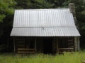
The field near the cabin is a primitive campsite only for park approved camping by Boy Scouts. Approval by the park must be obtained prior to use.
Most will start at Feagins Gap, thus approach from Lake Road.
Mostly straight shot down hollow. No blazes.
Mountain biking is only to the primitive campsite, then hiking only.
Former gravel road to primitive campsite. Then a dirt road to far west end. While there is a line on the map, that does not mean there is a trail on the ground. Past split to Pretty Ridge Trail has been abandoned by the park, thus no maintenance being done.