Back Hollow Road: Difference between revisions
(→Maps: Added coords for PR) |
(add pretty ridge to map) |
||
| (17 intermediate revisions by 3 users not shown) | |||
| Line 1: | Line 1: | ||
{{Trail | |||
{{ | |Banner Image=File:BMP cabin.JPG | ||
|Park=Bays Mountain Park | |||
|Land Owner=City of Kingsport | |||
|Trail Marking=Signs | |||
|Trail Use=Hiking, Biking, Geocaching | |||
|Difficulty Rating=Easy | |||
|Hike Time=30 Min | |||
|Trail Distance=1.944 mi | |||
|Round Trip Distance=6.9 mi | |||
|Trail Type=Segment | |||
|High Point=1,914 Ft | |||
|Low Point=1,607 ft | |||
|Elevation Gain=0 Ft | |||
|Elevation Loss=304 Ft | |||
|Elevation Change Direction=East-to-West | |||
|Parking location=36.50882, -82.60955 | |||
36. | |Trailhead location=36.50654, -82.63127 | ||
}} | }} | ||
{{Trail Map|Other Trails=Lake Road (Bays Mountain Park),Pretty Ridge Trail}} | |||
__TOC__ | |||
== Trail Overview == | == Trail Overview == | ||
<!-- Enter a overview of the trail. What attracts you to this trail, points of interest, types of flowers, lakes, and peaks that you see along the way. --> | <!-- Enter a overview of the trail. What attracts you to this trail, points of interest, types of flowers, lakes, and peaks that you see along the way. --> | ||
Located in [[Bays Mountain Park]]. Back Hollow Road leads to less used part of | Located in [[Bays Mountain Park]]. Back Hollow Road leads to less used part of the park from Feagins Gap past old cabins and a primitive camping area. The far western part becomes difficult to travel due to blowdowns and a creek that runs in the path. | ||
The field near the cabin is a primitive campsite only for park approved camping by Boy Scouts. Approval by the park must be obtained prior to use. | |||
== How to get there == | == How to get there == | ||
| Line 35: | Line 34: | ||
<!-- Detailed description of the route. Is there any side trails that are worth traveling? --> | <!-- Detailed description of the route. Is there any side trails that are worth traveling? --> | ||
Mostly straight shot down hollow. No blazes. | Mostly straight shot down hollow. No blazes. | ||
This trail has connections to [[Trail connects to::Lake Road (Bays Mountain Park)]], [[Trail connects to::River Mountain Road]], [[Trail connects to::Cross Ridges Trail]], [[Trail connects to::Pretty Ridge Trail]], and [[Trail connects to::Front Hollow Road]] | |||
{| class="wikitable" border="1" | {| class="wikitable" border="1" | ||
| Line 55: | Line 56: | ||
|- | |- | ||
|0.90 | |0.90 | ||
|Junction with [[ | |Junction with [[Pretty Ridge Trail|Pretty Ridge Trail]] and [[Cross Ridges Trail|Cross Ridges Trail]] | ||
|1675 | |1675 | ||
|- | |- | ||
| Line 71: | Line 72: | ||
|- | |- | ||
|1.95 | |1.95 | ||
|Connection with [[ | |Connection with [[Front Hollow Road|Front Hollow Road]] in meadow | ||
|1615 | |1615 | ||
|} | |} | ||
Mountain biking is only to the | Mountain biking is only to the primitive campsite, then hiking only. | ||
== Typical Conditions == | == Typical Conditions == | ||
<!-- Typical conditions throughout the year of what to expect on the trail. Rocky, muddy, sandy, flowers, lots of downed trees? --> | <!-- Typical conditions throughout the year of what to expect on the trail. Rocky, muddy, sandy, flowers, lots of downed trees? --> | ||
Former gravel road to | Former gravel road to primitive campsite. Then a dirt road to far west end. While there is a line on the map, that does not mean there is a trail on the ground. Past split to Pretty Ridge Trail has been abandoned by the park, thus no maintenance being done. | ||
== Photos == | == Photos == | ||
| Line 102: | Line 86: | ||
<!-- Place any pictures from this trail below. Ideally we would have a picture of the trailhead to help people know when they found it --> | <!-- Place any pictures from this trail below. Ideally we would have a picture of the trailhead to help people know when they found it --> | ||
<!-- Add a picture by typing Image:imagename.extension --> | <!-- Add a picture by typing Image:imagename.extension --> | ||
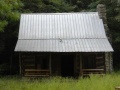
Image: | Image:BMP_cabin.JPG|Cabin near primative campsite | ||
</gallery> | </gallery> | ||
{{Map Marker | |||
|Icon Type=Trail sign | |||
[[ | |Marker Title=Feagins Gap | ||
|Marker Location=36.506548,-82.631278 | |||
}} | |||
{{Map Marker | |||
|Icon Type=Trail sign | |||
|Marker Title=Intersection at [[BMP Pretty Ridge Trail|Pretty Ridge Trail]] | |||
|Marker Location=36.4976,-82.6433 | |||
}} | |||
{{Map Marker | |||
|Icon Type=Campground | |||
|Marker Title=Log bridge to Primitive Campground | |||
|Marker Description=[[Image:BMP_Primative_Campground.JPG|150px]] | |||
|Marker Location=36.50049,-82.63936 | |||
}} | |||
{{Map Marker | |||
|Icon Type=Old structure | |||
|Marker Title=Park primitive cabin | |||
|Marker Description=[[Image:BMP_cabin.JPG|150px]] | |||
|Marker Location=36.50096,-82.6386 | |||
}} | |||
Latest revision as of 18:23, 17 December 2019
| Back Hollow Road (log in to submit report) | |
|---|---|

| |
| Park | Bays Mountain Park |
| Land Owner | City of Kingsport |
| Located | Kingsport, TennesseeLocation inherited from associated park |
| Trail Marking | Signs |
| Trail UseThings allowed to do on or near the trail |
|
| FeaturesThings to see on or near the trail |
|
| Difficulty Rating | Easy |
| Hiking TimeTime from car and back. Includes any time hiking to access this trail. | 30 Min0.5 Hours <br />0.0313 Days <br /> round trip |
| Distance: | 1.944 mi3.129 km <br /> trailStrict non-repeating trail length / 6.9 mi11.104 km <br /> round tripTypical or shortest length from the car, hike the trail, and return to car |
| Trail Type | Segment |
| Low / High Point | 1,607 ft535.667 Yards <br />489.814 Meters <br /> / 1,914 Ft638 Yards <br />583.387 Meters <br /> |
| Elev. Gain/LossSee link for details of calculation. Gain/Loss is direction dependent. | 0 Ft0 Meters <br /> / (304 Ft92.659 Meters <br />) – East-to-West |
| Trip ReportsFrom user "hiked it" submissions<br />Recent is within last 90 days | 2 logged hikes (0 recent) |
| NearbyWithin 5 mi<br />Click link to view list | 32 trails / 36.6 mi of trail |
| Parking | 36° 30' 31.75" N, 82° 36' 34.38" W Map |
| Trailhead | 36° 30' 23.54" N, 82° 37' 52.57" W Map |
|
| |
| Show In Google Maps | |
Download KML / Upload new version / KML File Page / Create Profile Chart / gpsvisualizer Map
Trail Overview[edit]
Located in Bays Mountain Park. Back Hollow Road leads to less used part of the park from Feagins Gap past old cabins and a primitive camping area. The far western part becomes difficult to travel due to blowdowns and a creek that runs in the path.
The field near the cabin is a primitive campsite only for park approved camping by Boy Scouts. Approval by the park must be obtained prior to use.
How to get there[edit]
Most will start at Feagins Gap, thus approach from Lake Road.
Route Description[edit]
Mostly straight shot down hollow. No blazes.
This trail has connections to Lake Road (Bays Mountain Park), River Mountain Road, Cross Ridges Trail, Pretty Ridge Trail, and Front Hollow Road
| Miles | Back Hollow Road | Elevation (ft) |
|---|---|---|
| 0.00 | Feagins Gap | 1910 |
| 0.56 | Cabin maintained by park | 1720 |
| 0.62 | Primative campsite | 1700 |
| 0.90 | Junction with Pretty Ridge Trail and Cross Ridges Trail | 1675 |
| 1.72 | Barbed wire fence gate | 1640 |
| 1.80 | Junction with Pretty Ridge Trail across field and behind barn. Look for sty over fence. | 1615 |
| 1.86 | Large gate - trail veers left | 1635 |
| 1.95 | Connection with Front Hollow Road in meadow | 1615 |
Mountain biking is only to the primitive campsite, then hiking only.
Typical Conditions[edit]
Former gravel road to primitive campsite. Then a dirt road to far west end. While there is a line on the map, that does not mean there is a trail on the ground. Past split to Pretty Ridge Trail has been abandoned by the park, thus no maintenance being done.
Photos[edit]
Cabin near primative campsite