Loading map...
{"format":"googlemaps3","type":"TERRAIN","minzoom":false,"maxzoom":false,"types":["SATELLITE","HYBRID","TERRAIN"],"limit":50,"offset":0,"link":"none","sort":[""],"order":[],"headers":"show","mainlabel":"","intro":"","outro":"","searchlabel":"... further results","default":"","import-annotation":false,"width":"auto","height":"600px","centre":false,"title":"","label":"","icon":"","lines":[],"polygons":[],"circles":[],"rectangles":[],"copycoords":false,"static":false,"visitedicon":"","wmsoverlay":false,"zoom":false,"layers":[],"controls":["pan","zoom","type","scale","streetview","rotate"],"zoomstyle":"DEFAULT","typestyle":"DEFAULT","autoinfowindows":false,"resizable":false,"kmlrezoom":true,"poi":true,"cluster":false,"clustergridsize":60,"clustermaxzoom":20,"clusterzoomonclick":true,"clusteraveragecenter":true,"clusterminsize":2,"imageoverlays":[],"kml":[],"gkml":["https://tehcc.org/clubwiki/images/Azalea.kml","https://tehcc.org/clubwiki/images/Cross_Ridges_Trail.kml","https://tehcc.org/clubwiki/images/Front_Hollow_Road.kml","https://tehcc.org/clubwiki/images/Lake_Road_(Bays_Mountain_Park).kml","https://tehcc.org/clubwiki/images/Pretty_Ridge_Trail.kml","https://tehcc.org/clubwiki/images/River_Mountain_Road.kml"],"searchmarkers":"","fullscreen":false,"scrollwheelzoom":false,"showtitle":false,"hidenamespace":true,"template":"Map Balloon Template","userparam":"","activeicon":"","pagelabel":false,"ajaxcoordproperty":"","ajaxquery":"","locations":[{"text":"\u003Cp\u003E\u003Cb\u003E\u003Ca class=\"mw-selflink selflink\"\u003EAzalea\u003C/a\u003E\u003C/b\u003E\u003Cbr /\u003E\u003C/p\u003E\u003Chr /\u003E\u003Cp\u003E1.37\u0026#160;Mi (2.21\u0026#160;km)\u003Cbr /\u003EDifficulty: Hard\u003Cbr /\u003EMarking: Signs\u003C/p\u003E","title":"Azalea","link":"","lat":36.51263000000000147338141687214374542236328125,"lon":-82.60511999999999943611328490078449249267578125,"icon":"/clubwiki/images/MarkerT.png"},{"text":"\u003Cp\u003E\u003Cb\u003EIntersection at \u003Ca href=\"/wiki/Big_Oak_Trail\" title=\"Big Oak Trail\"\u003EBig Oak Trail\u003C/a\u003E\u003C/b\u003E\u003Cbr /\u003E\u003C/p\u003E\u003Chr /\u003E\u003Cp\u003E\u003Ca href=\"/wiki/File:BMP_Split_at_Azalea_and_Big_Oak_Trails.JPG\" class=\"image\"\u003E\u003Cimg alt=\"BMP Split at Azalea and Big Oak Trails.JPG\" src=\"/clubwiki/images/thumb/BMP_Split_at_Azalea_and_Big_Oak_Trails.JPG/100px-BMP_Split_at_Azalea_and_Big_Oak_Trails.JPG\" decoding=\"async\" width=\"100\" height=\"75\" srcset=\"/clubwiki/images/thumb/BMP_Split_at_Azalea_and_Big_Oak_Trails.JPG/150px-BMP_Split_at_Azalea_and_Big_Oak_Trails.JPG 1.5x, /clubwiki/images/thumb/BMP_Split_at_Azalea_and_Big_Oak_Trails.JPG/200px-BMP_Split_at_Azalea_and_Big_Oak_Trails.JPG 2x\" data-file-width=\"448\" data-file-height=\"336\" /\u003E\u003C/a\u003E\u003C/p\u003E","title":"Azalea","link":"","lat":36.522210000000001173248165287077426910400390625,"lon":-82.5928300000000064073901739902794361114501953125,"icon":"/clubwiki/images/MarkerG.png"},{"text":"\u003Cp\u003E\u003Cb\u003ETrailhead at \u003Ca href=\"/wiki/Bays_Mountain_Road\" title=\"Bays Mountain Road\"\u003EBays Mountain Road\u003C/a\u003E\u003C/b\u003E\u003Cbr /\u003E\u003C/p\u003E\u003Chr /\u003E\u003Cp\u003E\u003Ca href=\"/wiki/File:BMP_Azalea_Trail_sign_at_BMR.JPG\" class=\"image\"\u003E\u003Cimg alt=\"BMP Azalea Trail sign at BMR.JPG\" src=\"/clubwiki/images/thumb/BMP_Azalea_Trail_sign_at_BMR.JPG/50px-BMP_Azalea_Trail_sign_at_BMR.JPG\" decoding=\"async\" width=\"50\" height=\"174\" srcset=\"/clubwiki/images/thumb/BMP_Azalea_Trail_sign_at_BMR.JPG/75px-BMP_Azalea_Trail_sign_at_BMR.JPG 1.5x, /clubwiki/images/thumb/BMP_Azalea_Trail_sign_at_BMR.JPG/100px-BMP_Azalea_Trail_sign_at_BMR.JPG 2x\" data-file-width=\"129\" data-file-height=\"448\" /\u003E\u003C/a\u003E\u003C/p\u003E","title":"Azalea","link":"","lat":36.52613999999999805368133820593357086181640625,"lon":-82.5877200000000044610715121962130069732666015625,"icon":"/clubwiki/images/MarkerG.png"},{"text":"\u003Cp\u003E\u003Cb\u003ETrailhead at \u003Ca href=\"/wiki/Lake_Road\" title=\"Lake Road\"\u003ELake Road\u003C/a\u003E\u003C/b\u003E\u003Cbr /\u003E\u003C/p\u003E\u003Chr /\u003E\u003Cp\u003E\u003Ca href=\"/wiki/File:BMP_Azalea_Trail_sign.JPG\" class=\"image\"\u003E\u003Cimg alt=\"BMP Azalea Trail sign.JPG\" src=\"/clubwiki/images/thumb/BMP_Azalea_Trail_sign.JPG/50px-BMP_Azalea_Trail_sign.JPG\" decoding=\"async\" width=\"50\" height=\"160\" srcset=\"/clubwiki/images/thumb/BMP_Azalea_Trail_sign.JPG/75px-BMP_Azalea_Trail_sign.JPG 1.5x, /clubwiki/images/thumb/BMP_Azalea_Trail_sign.JPG/100px-BMP_Azalea_Trail_sign.JPG 2x\" data-file-width=\"140\" data-file-height=\"448\" /\u003E\u003C/a\u003E\u003C/p\u003E","title":"Azalea","link":"","lat":36.512619999999998299244907684624195098876953125,"lon":-82.605199999999996407495927996933460235595703125,"icon":"/clubwiki/images/MarkerG.png"},{"text":"\u003Cp\u003E\u003Cb\u003E\u003Ca href=\"/wiki/Cross_Ridges_Trail\" title=\"Cross Ridges Trail\"\u003ECross Ridges Trail\u003C/a\u003E\u003C/b\u003E\u003Cbr /\u003E\u003C/p\u003E\u003Chr /\u003E\u003Cp\u003E0.64\u0026#160;Mi (1.03\u0026#160;km)\u003Cbr /\u003EDifficulty: Medium\u003Cbr /\u003EMarking: Signs\u003C/p\u003E","title":"Cross Ridges Trail","link":"","lat":36.49777000000000271029421128332614898681640625,"lon":-82.6427000000000049340087571181356906890869140625,"icon":"/clubwiki/images/MarkerT.png"},{"text":"\u003Cp\u003E\u003Cb\u003EJunction with \u003Ca href=\"/wiki/Cherry_Knobs\" title=\"Cherry Knobs\"\u003ECherry Knobs\u003C/a\u003E\u003C/b\u003E\u003Cbr /\u003E\u003C/p\u003E\u003Chr /\u003E\u003Cp\u003E\u003Ca href=\"/wiki/File:BMP_CK-CR_sign.JPG\" class=\"image\"\u003E\u003Cimg alt=\"BMP CK-CR sign.JPG\" src=\"/clubwiki/images/thumb/BMP_CK-CR_sign.JPG/50px-BMP_CK-CR_sign.JPG\" decoding=\"async\" width=\"50\" height=\"142\" srcset=\"/clubwiki/images/thumb/BMP_CK-CR_sign.JPG/75px-BMP_CK-CR_sign.JPG 1.5x, /clubwiki/images/thumb/BMP_CK-CR_sign.JPG/100px-BMP_CK-CR_sign.JPG 2x\" data-file-width=\"158\" data-file-height=\"448\" /\u003E\u003C/a\u003E\u003C/p\u003E","title":"Cross Ridges Trail","link":"","lat":36.4968300000000027694113668985664844512939453125,"lon":-82.636290000000002464730641804635524749755859375,"icon":"/clubwiki/images/MarkerT.png"},{"text":"\u003Cp\u003E\u003Cb\u003EJunction with \u003Ca href=\"/wiki/Back_Hollow_Road\" title=\"Back Hollow Road\"\u003EBack Hollow Road\u003C/a\u003E\u003C/b\u003E\u003Cbr /\u003E\u003C/p\u003E\u003Chr /\u003E\u003Cp\u003Eand \u003Ca href=\"/wiki/Pretty_Ridge_Trail\" title=\"Pretty Ridge Trail\"\u003EPretty Ridge Trail\u003C/a\u003E\u003C/p\u003E","title":"Cross Ridges Trail","link":"","lat":36.49777000000000271029421128332614898681640625,"lon":-82.6426900000000017598722479306161403656005859375,"icon":"/clubwiki/images/MarkerT.png"},{"text":"\u003Cp\u003E\u003Cb\u003ETrailhead at \u003Ca href=\"/wiki/Front_Hollow_Road\" title=\"Front Hollow Road\"\u003EFront Hollow Road\u003C/a\u003E\u003C/b\u003E\u003Cbr /\u003E\u003C/p\u003E\u003Chr /\u003E\u003Cp\u003E\u003Ca href=\"/wiki/File:BMP_CR_FHR_sign.JPG\" class=\"image\"\u003E\u003Cimg alt=\"BMP CR FHR sign.JPG\" src=\"/clubwiki/images/thumb/BMP_CR_FHR_sign.JPG/50px-BMP_CR_FHR_sign.JPG\" decoding=\"async\" width=\"50\" height=\"209\" srcset=\"/clubwiki/images/thumb/BMP_CR_FHR_sign.JPG/75px-BMP_CR_FHR_sign.JPG 1.5x, /clubwiki/images/thumb/BMP_CR_FHR_sign.JPG/100px-BMP_CR_FHR_sign.JPG 2x\" data-file-width=\"107\" data-file-height=\"448\" /\u003E\u003C/a\u003E\u003C/p\u003E","title":"Cross Ridges Trail","link":"","lat":36.4951099999999968304109643213450908660888671875,"lon":-82.634379999999993060555425472557544708251953125,"icon":"/clubwiki/images/MarkerT.png"},{"text":"\u003Cp\u003E\u003Cb\u003EStream crossing - no bridge\u003C/b\u003E\u003Cbr /\u003E\u003C/p\u003E\u003Chr /\u003E\u003Cp\u003E\u003Ca href=\"/wiki/File:BMP_Cross_Ridges_Trail_stream_crossing.JPG\" class=\"image\"\u003E\u003Cimg alt=\"BMP Cross Ridges Trail stream crossing.JPG\" src=\"/clubwiki/images/thumb/BMP_Cross_Ridges_Trail_stream_crossing.JPG/150px-BMP_Cross_Ridges_Trail_stream_crossing.JPG\" decoding=\"async\" width=\"150\" height=\"200\" srcset=\"/clubwiki/images/thumb/BMP_Cross_Ridges_Trail_stream_crossing.JPG/225px-BMP_Cross_Ridges_Trail_stream_crossing.JPG 1.5x, /clubwiki/images/thumb/BMP_Cross_Ridges_Trail_stream_crossing.JPG/300px-BMP_Cross_Ridges_Trail_stream_crossing.JPG 2x\" data-file-width=\"768\" data-file-height=\"1024\" /\u003E\u003C/a\u003E\u003C/p\u003E","title":"Cross Ridges Trail","link":"","lat":36.49770000000000180762071977369487285614013671875,"lon":-82.6424999999999982946974341757595539093017578125,"icon":"/clubwiki/images/MarkerJ.png"},{"text":"\u003Cp\u003E\u003Cb\u003E\u003Ca href=\"/wiki/Front_Hollow_Road\" title=\"Front Hollow Road\"\u003EFront Hollow Road\u003C/a\u003E\u003C/b\u003E\u003Cbr /\u003E\u003C/p\u003E\u003Chr /\u003E\u003Cp\u003E1.70\u0026#160;Mi (2.74\u0026#160;km)\u003Cbr /\u003EDifficulty: Medium\u003Cbr /\u003EMarking: Signs\u003C/p\u003E","title":"Front Hollow Road","link":"","lat":36.4978100000000011959855328314006328582763671875,"lon":-82.6276500000000027057467377744615077972412109375,"icon":"/clubwiki/images/MarkerT.png"},{"text":"\u003Cp\u003E\u003Cb\u003E\u003Ca href=\"/wiki/Lake_Road_(Bays_Mountain_Park)\" title=\"Lake Road (Bays Mountain Park)\"\u003ELake Road (Bays Mountain Park)\u003C/a\u003E\u003C/b\u003E\u003Cbr /\u003E\u003C/p\u003E\u003Chr /\u003E\u003Cp\u003E4.33\u0026#160;Mi (6.96\u0026#160;km)\u003Cbr /\u003EDifficulty: Easy\u003Cbr /\u003EMarking: Signs\u003C/p\u003E","title":"Lake Road (Bays Mountain Park)","link":"","lat":36.50645999999999702367858844809234142303466796875,"lon":-82.63128000000000383806764148175716400146484375,"icon":"/clubwiki/images/MarkerT.png"},{"text":"\u003Cp\u003E\u003Cb\u003ELedbetter Gap\u003C/b\u003E\u003Cbr /\u003E\u003C/p\u003E\u003Chr /\u003E\u003Cp\u003E\u003Ca href=\"/wiki/File:BMP_Ledbetter_Gap_sign.JPG\" class=\"image\"\u003E\u003Cimg alt=\"BMP Ledbetter Gap sign.JPG\" src=\"/clubwiki/images/thumb/BMP_Ledbetter_Gap_sign.JPG/150px-BMP_Ledbetter_Gap_sign.JPG\" decoding=\"async\" width=\"150\" height=\"148\" srcset=\"/clubwiki/images/thumb/BMP_Ledbetter_Gap_sign.JPG/225px-BMP_Ledbetter_Gap_sign.JPG 1.5x, /clubwiki/images/thumb/BMP_Ledbetter_Gap_sign.JPG/300px-BMP_Ledbetter_Gap_sign.JPG 2x\" data-file-width=\"340\" data-file-height=\"336\" /\u003E\u003C/a\u003E\u003Cbr /\u003ECrossroads with \u003Ca href=\"/wiki/Bays_Ridge_Road\" title=\"Bays Ridge Road\"\u003EBays Ridge Road\u003C/a\u003E and \u003Ca href=\"/wiki/Front_Hollow_Road\" title=\"Front Hollow Road\"\u003EFront Hollow Road\u003C/a\u003E\u003C/p\u003E","title":"Lake Road (Bays Mountain Park)","link":"","lat":36.4979000000000013415046851150691509246826171875,"lon":-82.627712999999999965439201332628726959228515625,"icon":"/clubwiki/images/MarkerT.png"},{"text":"\u003Cp\u003E\u003Cb\u003E\u003Ca href=\"/wiki/Orchid_Trail\" title=\"Orchid Trail\"\u003EOrchid Trail\u003C/a\u003E\u003C/b\u003E\u003Cbr /\u003E\u003C/p\u003E\u003Chr /\u003E\u003Cp\u003E\u003Ca href=\"/wiki/File:BMP_Orchid_Trail_sign.JPG\" class=\"image\"\u003E\u003Cimg alt=\"BMP Orchid Trail sign.JPG\" src=\"/clubwiki/images/thumb/BMP_Orchid_Trail_sign.JPG/50px-BMP_Orchid_Trail_sign.JPG\" decoding=\"async\" width=\"50\" height=\"89\" srcset=\"/clubwiki/images/thumb/BMP_Orchid_Trail_sign.JPG/75px-BMP_Orchid_Trail_sign.JPG 1.5x, /clubwiki/images/thumb/BMP_Orchid_Trail_sign.JPG/100px-BMP_Orchid_Trail_sign.JPG 2x\" data-file-width=\"252\" data-file-height=\"448\" /\u003E\u003C/a\u003E\u003C/p\u003E","title":"Lake Road (Bays Mountain Park)","link":"","lat":36.50348999999999932697392068803310394287109375,"lon":-82.618930000000005975380190648138523101806640625,"icon":"/clubwiki/images/MarkerT.png"},{"text":"\u003Cp\u003E\u003Cb\u003ECrossroads\u003C/b\u003E\u003Cbr /\u003E\u003C/p\u003E\u003Chr /\u003E\u003Cp\u003E\u003Ca href=\"/wiki/Back_Hollow_Road\" title=\"Back Hollow Road\"\u003EBack Hollow Road\u003C/a\u003E and \u003Ca href=\"/wiki/River_Mountain_Road\" title=\"River Mountain Road\"\u003ERiver Mountain Road\u003C/a\u003E\u003C/p\u003E","title":"Lake Road (Bays Mountain Park)","link":"","lat":36.50654800000000221871232497505843639373779296875,"lon":-82.6312779999999946767275105230510234832763671875,"icon":"/clubwiki/images/MarkerT.png"},{"text":"\u003Cp\u003E\u003Cb\u003EOld quarry used for stone to create reservoir dam\u003C/b\u003E\u003Cbr /\u003E\u003C/p\u003E\u003Chr /\u003E\u003Cp\u003EOld quarry used for stone to create reservoir dam\u003C/p\u003E","title":"Lake Road (Bays Mountain Park)","link":"","lat":36.50513000000000118916432256810367107391357421875,"lon":-82.6295300000000025875124265439808368682861328125,"icon":"/clubwiki/images/MarkerD.png"},{"text":"\u003Cp\u003E\u003Cb\u003E\u003Ca href=\"/wiki/Cherry_Knobs\" title=\"Cherry Knobs\"\u003ECherry Knobs\u003C/a\u003E\u003C/b\u003E\u003Cbr /\u003E\u003C/p\u003E\u003Chr /\u003E\u003Cp\u003E\u003Ca href=\"/wiki/Cherry_Knobs\" title=\"Cherry Knobs\"\u003ECherry Knobs\u003C/a\u003E\u003C/p\u003E","title":"Lake Road (Bays Mountain Park)","link":"","lat":36.50344799999999878536982578225433826446533203125,"lon":-82.6285299999999978126652422361075878143310546875,"icon":"/clubwiki/images/MarkerT.png"},{"text":"\u003Cp\u003E\u003Cb\u003E\u003Ca href=\"/wiki/Pine_Trail\" title=\"Pine Trail\"\u003EPine Trail\u003C/a\u003E\u003C/b\u003E\u003Cbr /\u003E\u003C/p\u003E\u003Chr /\u003E\u003Cp\u003E\u003Ca href=\"/wiki/Pine_Trail\" title=\"Pine Trail\"\u003EPine Trail\u003C/a\u003E\u003C/p\u003E","title":"Lake Road (Bays Mountain Park)","link":"","lat":36.50708800000000309182723867706954479217529296875,"lon":-82.61354000000000041836756281554698944091796875,"icon":"/clubwiki/images/MarkerT.png"},{"text":"\u003Cp\u003E\u003Cb\u003EJunction with \u003Ca href=\"/wiki/Chinquapin_Trail\" title=\"Chinquapin Trail\"\u003EChinquapin Trail\u003C/a\u003E\u003C/b\u003E\u003Cbr /\u003E\u003C/p\u003E\u003Chr /\u003E\u003Cp\u003EJunction with \u003Ca href=\"/wiki/Chinquapin_Trail\" title=\"Chinquapin Trail\"\u003EChinquapin Trail\u003C/a\u003E\u003C/p\u003E","title":"Lake Road (Bays Mountain Park)","link":"","lat":36.50945999999999713736542616970837116241455078125,"lon":-82.62130999999999403371475636959075927734375,"icon":"/clubwiki/images/MarkerT.png"},{"text":"\u003Cp\u003E\u003Cb\u003E\u003Ca href=\"/wiki/Cherry_Knobs\" title=\"Cherry Knobs\"\u003ECherry Knobs\u003C/a\u003E\u003C/b\u003E\u003Cbr /\u003E\u003C/p\u003E\u003Chr /\u003E\u003Cp\u003E\u003Ca href=\"/wiki/Cherry_Knobs\" title=\"Cherry Knobs\"\u003ECherry Knobs\u003C/a\u003E\u003C/p\u003E","title":"Lake Road (Bays Mountain Park)","link":"","lat":36.50097199999999730835043010301887989044189453125,"lon":-82.6309739999999948167896945960819721221923828125,"icon":"/clubwiki/images/MarkerT.png"},{"text":"\u003Cp\u003E\u003Cb\u003E\u003Ca href=\"/wiki/Bays_Ridge_Road\" title=\"Bays Ridge Road\"\u003EBays Ridge Road\u003C/a\u003E\u003C/b\u003E\u003Cbr /\u003E\u003C/p\u003E\u003Chr /\u003E\u003Cp\u003E\u003Ca href=\"/wiki/File:BMP_LakeRd-BaysRidgeRd_sign.JPG\" class=\"image\"\u003E\u003Cimg alt=\"BMP LakeRd-BaysRidgeRd sign.JPG\" src=\"/clubwiki/images/thumb/BMP_LakeRd-BaysRidgeRd_sign.JPG/50px-BMP_LakeRd-BaysRidgeRd_sign.JPG\" decoding=\"async\" width=\"50\" height=\"179\" srcset=\"/clubwiki/images/thumb/BMP_LakeRd-BaysRidgeRd_sign.JPG/75px-BMP_LakeRd-BaysRidgeRd_sign.JPG 1.5x, /clubwiki/images/thumb/BMP_LakeRd-BaysRidgeRd_sign.JPG/100px-BMP_LakeRd-BaysRidgeRd_sign.JPG 2x\" data-file-width=\"125\" data-file-height=\"448\" /\u003E\u003C/a\u003E\u003C/p\u003E","title":"Lake Road (Bays Mountain Park)","link":"","lat":36.50761299999999920373738859780132770538330078125,"lon":-82.6126579999999961501089273951947689056396484375,"icon":"/clubwiki/images/MarkerT.png"},{"text":"\u003Cp\u003E\u003Cb\u003E\u003Ca href=\"/wiki/Pretty_Ridge_Trail\" title=\"Pretty Ridge Trail\"\u003EPretty Ridge Trail\u003C/a\u003E\u003C/b\u003E\u003Cbr /\u003E\u003C/p\u003E\u003Chr /\u003E\u003Cp\u003E1.72\u0026#160;Mi (2.76\u0026#160;km)\u003Cbr /\u003EDifficulty: Hard\u003Cbr /\u003EMarking: Signs\u003C/p\u003E","title":"Pretty Ridge Trail","link":"","lat":36.49763999999999697365637985058128833770751953125,"lon":-82.6432999999999964302332955412566661834716796875,"icon":"/clubwiki/images/MarkerT.png"},{"text":"\u003Cp\u003E\u003Cb\u003EWestern descent from ridge\u003C/b\u003E\u003Cbr /\u003E\u003C/p\u003E\u003Chr /\u003E\u003Cp\u003EWestern descent from ridge\u003C/p\u003E","title":"Pretty Ridge Trail","link":"","lat":36.4915739999999999554347596131265163421630859375,"lon":-82.657148000000006504706107079982757568359375,"icon":"/clubwiki/images/MarkerG.png"},{"text":"\u003Cp\u003E\u003Cb\u003EIntersection at \u003Ca href=\"/wiki/Back_Hollow_Road\" title=\"Back Hollow Road\"\u003EBack Hollow Road\u003C/a\u003E\u003C/b\u003E\u003Cbr /\u003E\u003C/p\u003E\u003Chr /\u003E\u003Cp\u003EIntersection at \u003Ca href=\"/wiki/Back_Hollow_Road\" title=\"Back Hollow Road\"\u003EBack Hollow Road\u003C/a\u003E\u003C/p\u003E","title":"Pretty Ridge Trail","link":"","lat":36.48818200000000189220372703857719898223876953125,"lon":-82.6537770000000051595634431578218936920166015625,"icon":"/clubwiki/images/MarkerT.png"},{"text":"\u003Cp\u003E\u003Cb\u003EIntersection at \u003Ca href=\"/wiki/Back_Hollow_Road\" title=\"Back Hollow Road\"\u003EBack Hollow Road\u003C/a\u003E\u003C/b\u003E\u003Cbr /\u003E\u003C/p\u003E\u003Chr /\u003E\u003Cp\u003EIntersection at \u003Ca href=\"/wiki/Back_Hollow_Road\" title=\"Back Hollow Road\"\u003EBack Hollow Road\u003C/a\u003E\u003C/p\u003E","title":"Pretty Ridge Trail","link":"","lat":36.49759999999999848796505830250680446624755859375,"lon":-82.6432999999999964302332955412566661834716796875,"icon":"/clubwiki/images/MarkerT.png"},{"text":"\u003Cp\u003E\u003Cb\u003ESty across fence\u003C/b\u003E\u003Cbr /\u003E\u003C/p\u003E\u003Chr /\u003E\u003Cp\u003E\u003Ca href=\"/wiki/File:BMP_Pretty_Ridge_Trail_sty.JPG\" class=\"image\"\u003E\u003Cimg alt=\"BMP Pretty Ridge Trail sty.JPG\" src=\"/clubwiki/images/thumb/BMP_Pretty_Ridge_Trail_sty.JPG/150px-BMP_Pretty_Ridge_Trail_sty.JPG\" decoding=\"async\" width=\"150\" height=\"200\" srcset=\"/clubwiki/images/thumb/BMP_Pretty_Ridge_Trail_sty.JPG/225px-BMP_Pretty_Ridge_Trail_sty.JPG 1.5x, /clubwiki/images/thumb/BMP_Pretty_Ridge_Trail_sty.JPG/300px-BMP_Pretty_Ridge_Trail_sty.JPG 2x\" data-file-width=\"336\" data-file-height=\"448\" /\u003E\u003C/a\u003E\u003C/p\u003E","title":"Pretty Ridge Trail","link":"","lat":36.48915000000000219415596802718937397003173828125,"lon":-82.65420000000000300133251585066318511962890625,"icon":"/clubwiki/images/MarkerG.png"},{"text":"\u003Cp\u003E\u003Cb\u003E\u003Ca href=\"/wiki/River_Mountain_Road\" title=\"River Mountain Road\"\u003ERiver Mountain Road\u003C/a\u003E\u003C/b\u003E\u003Cbr /\u003E\u003C/p\u003E\u003Chr /\u003E\u003Cp\u003E3.21\u0026#160;Mi (5.16\u0026#160;km)\u003Cbr /\u003EDifficulty: Medium\u003Cbr /\u003EMarking: Signs\u003C/p\u003E","title":"River Mountain Road","link":"","lat":36.5166100000000000136424205265939235687255859375,"lon":-82.609340000000003101376933045685291290283203125,"icon":"/clubwiki/images/MarkerT.png"},{"text":"\u003Cp\u003E\u003Cb\u003E1937 CCC Built Fire Tower\u003C/b\u003E\u003Cbr /\u003E\u003C/p\u003E\u003Chr /\u003E\u003Cp\u003E1937 CCC Built Fire Tower\u003C/p\u003E","title":"River Mountain Road","link":"","lat":36.51547000000000053887561080045998096466064453125,"lon":-82.6241639999999932797436485998332500457763671875,"icon":"/clubwiki/images/MarkerE.png"},{"text":"\u003Cp\u003E\u003Cb\u003EComm Tower\u003C/b\u003E\u003Cbr /\u003E\u003C/p\u003E\u003Chr /\u003E\u003Cp\u003EComm Tower\u003C/p\u003E","title":"River Mountain Road","link":"","lat":36.52386200000000116006049211136996746063232421875,"lon":-82.59611599999999498322722502052783966064453125,"icon":"/clubwiki/images/MarkerM.png"},{"text":"\u003Cp\u003E\u003Cb\u003E\u003Ca href=\"/wiki/Indian_Pipes_Trail\" title=\"Indian Pipes Trail\"\u003EIndian Pipes Trail\u003C/a\u003E\u003C/b\u003E\u003Cbr /\u003E\u003C/p\u003E\u003Chr /\u003E\u003Cp\u003E\u003Ca href=\"/wiki/Indian_Pipes_Trail\" title=\"Indian Pipes Trail\"\u003EIndian Pipes Trail\u003C/a\u003E\u003C/p\u003E","title":"River Mountain Road","link":"","lat":36.51359000000000065710992203094065189361572265625,"lon":-82.6276270000000039317455957643687725067138671875,"icon":"/clubwiki/images/MarkerT.png"},{"text":"\u003Cp\u003E\u003Cb\u003E\u003Ca class=\"mw-selflink selflink\"\u003EAzalea Trail\u003C/a\u003E\u003C/b\u003E\u003Cbr /\u003E\u003C/p\u003E\u003Chr /\u003E\u003Cp\u003E\u003Ca class=\"mw-selflink selflink\"\u003EAzalea Trail\u003C/a\u003E\u003C/p\u003E","title":"River Mountain Road","link":"","lat":36.52616299999999682768248021602630615234375,"lon":-82.58778200000000424552126787602901458740234375,"icon":"/clubwiki/images/MarkerG.png"},{"text":"\u003Cp\u003E\u003Cb\u003EComm Tower\u003C/b\u003E\u003Cbr /\u003E\u003C/p\u003E\u003Chr /\u003E\u003Cp\u003EComm Tower\u003C/p\u003E","title":"River Mountain Road","link":"","lat":36.5249179999999995516191120259463787078857421875,"lon":-82.592412999999993417077348567545413970947265625,"icon":"/clubwiki/images/MarkerM.png"},{"text":"\u003Cp\u003E\u003Cb\u003ECrossroads\u003C/b\u003E\u003Cbr /\u003E\u003C/p\u003E\u003Chr /\u003E\u003Cp\u003E\u003Ca href=\"/wiki/Back_Hollow_Road\" title=\"Back Hollow Road\"\u003EBack Hollow Road\u003C/a\u003E and \u003Ca href=\"/clubwiki/index.php?title=Lake_Road(Bays_Mountain_Park)\u0026amp;action=edit\u0026amp;redlink=1\" class=\"new\" title=\"Lake Road(Bays Mountain Park) (page does not exist)\"\u003ELake Road\u003C/a\u003E\u003Cbr /\u003EAt Feagin's Gap\u003C/p\u003E","title":"River Mountain Road","link":"","lat":36.50654800000000221871232497505843639373779296875,"lon":-82.6312779999999946767275105230510234832763671875,"icon":"/clubwiki/images/MarkerG.png"}]}
From the main parking lot, pass through or around the bird and wolf habitats to reach Lake Road. Continue around to marked trailhead.
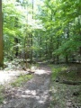
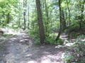
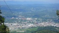
The path runs right up the hollow along side of an intermittent runoff stream. One up on Bays Mountain Road, many folks would continue up to the Antennas for the view of downtown Kingsport.
Hard packed and sometimes rutted trail. The runoff stream can flow down the trail during spring or hard rains. Park does a great job of cutting through the blowdowns.