Chinquapin Trail
| |||||||||||||||||||||||||||||||||||||

Trail Overview
Located in Bays Mountain Park. New mountain biking trail constructed by the local club. Good for an easier ride or hike through hardwood forest dotted with hemlocks.
How to get there
From the main parking lot, take Lake Road around to UNmarked trailhead or jump on Big Oak for short distance for other trailhead.
Route Description
The path meaders through the forest with planned switchbacks and bridge crossing.
| Miles | Chinquapin Trail | Miles |
|---|---|---|
| 0.0 | Trailhead at Lake Road | 1.85 |
| 0.7 | Junction with Firetower Trail | 1.15 |
| 1.85 | Trailhead at Big Oak Trail | 0.0 |
Typical Conditions
Hard packed trail with groove down the middle from the mountain bikes. Some rocks located at key spots. Several wood bridges constructed by BSA Troop 51.
Misc. Information
Maps
<googlemap version="0.9" lat="36.514" lon="-82.612" type="terrain" zoom="15" width="725" icons="http://tehcc.org/clubwiki/kml/marker{label}.png"> http://tehcc.org/clubwiki/kml/BMP_Chinquapin_Trail.kml http://tehcc.org/clubwiki/kml/BMP_lake_road.kml http://tehcc.org/clubwiki/kml/BMP_Firetower_Trail.kml http://tehcc.org/clubwiki/kml/BMP_Big_Oak_Trail.kml
(G) 36.51452,-82.60601
Trailhead at Big Oak
 (G) 36.51276,-82.61764
Junction with Firetower Trail
(G) 36.51276,-82.61764
Junction with Firetower Trail
 (G) 36.50951,-82.62137
Trailhead at Lake Road
(L) 36.51527,-82.60722
Trail bridge by Troop 51
(G) 36.50951,-82.62137
Trailhead at Lake Road
(L) 36.51527,-82.60722
Trail bridge by Troop 51
 (L) 36.51268,-82.61879
Trail bridge by Troop 51
(L) 36.51268,-82.61879
Trail bridge by Troop 51
 (L) 36.51067,-82.62083
</googlemap>
Photos
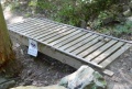
BSA Built Bridge
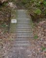
BSA Built Bridge